NorthArlington101
-
Posts
12,475 -
Joined
-
Last visited
Content Type
Profiles
Blogs
Forums
American Weather
Media Demo
Store
Gallery
Everything posted by NorthArlington101
-
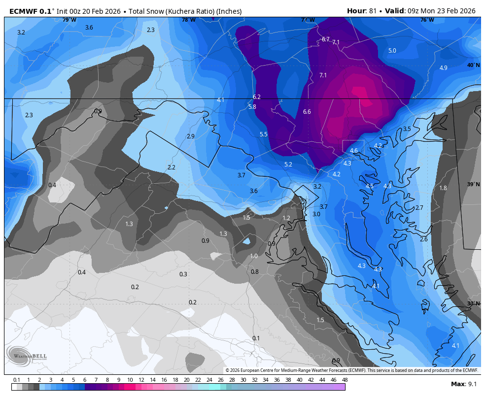
that's a color you don't see much
-

Feb 22nd/23rd "There's no way..." Storm Thread
NorthArlington101 replied to Maestrobjwa's topic in Mid Atlantic
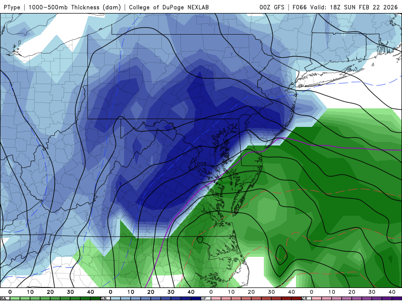
Temp related 100% but that's how the screwjob would happen. DC starts as rain, coastal happens too west, then we miss the IVT -
Feb 22nd/23rd "There's no way..." Storm Thread
NorthArlington101 replied to Maestrobjwa's topic in Mid Atlantic
1/3/22 was the last GFS coup. I was in Puerto Rico. Thought it couldn't be right for days, that it would cave. Then... -
Feb 22nd/23rd "There's no way..." Storm Thread
NorthArlington101 replied to Maestrobjwa's topic in Mid Atlantic
3k shows the DC disaster gap but it would've filled in a bit on later panels -
Feb 22nd/23rd "There's no way..." Storm Thread
NorthArlington101 replied to Maestrobjwa's topic in Mid Atlantic
I'd rather be in the Virginia' delmarva but not gonna kick a 6-8" NAM run out of bed -
Feb 22nd/23rd "There's no way..." Storm Thread
NorthArlington101 replied to Maestrobjwa's topic in Mid Atlantic
It's not gonna be nuts but a solid warning criteria storm for most of us -
Feb 22nd/23rd "There's no way..." Storm Thread
NorthArlington101 replied to Maestrobjwa's topic in Mid Atlantic
You gotta like your spot for this one. How is your guest bedroom situation? -
Feb 22nd/23rd "There's no way..." Storm Thread
NorthArlington101 replied to Maestrobjwa's topic in Mid Atlantic
If I don’t get at least 6” the only thing the GFS will get is hate -
Feb 22nd/23rd "There's no way..." Storm Thread
NorthArlington101 replied to Maestrobjwa's topic in Mid Atlantic
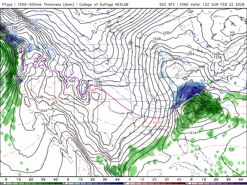
IVT might be pretty nice on this run. Need ptype maps -
Feb 22nd/23rd "There's no way..." Storm Thread
NorthArlington101 replied to Maestrobjwa's topic in Mid Atlantic
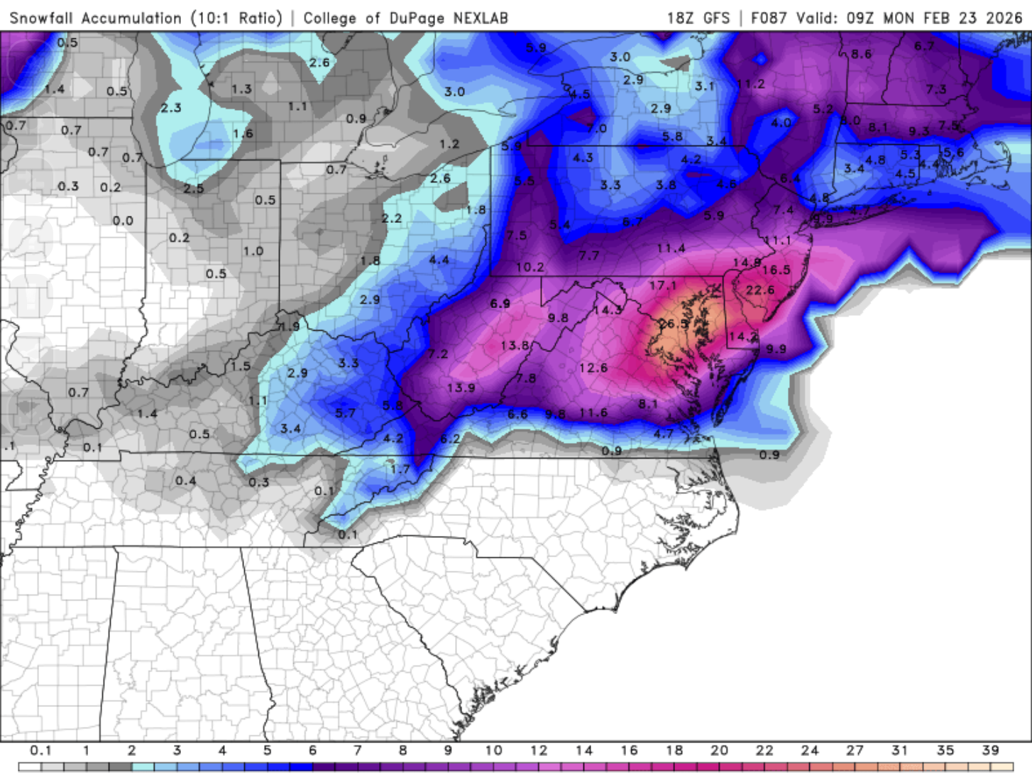
maybe a tenth more… all but final
-
Feb 22nd/23rd "There's no way..." Storm Thread
NorthArlington101 replied to Maestrobjwa's topic in Mid Atlantic
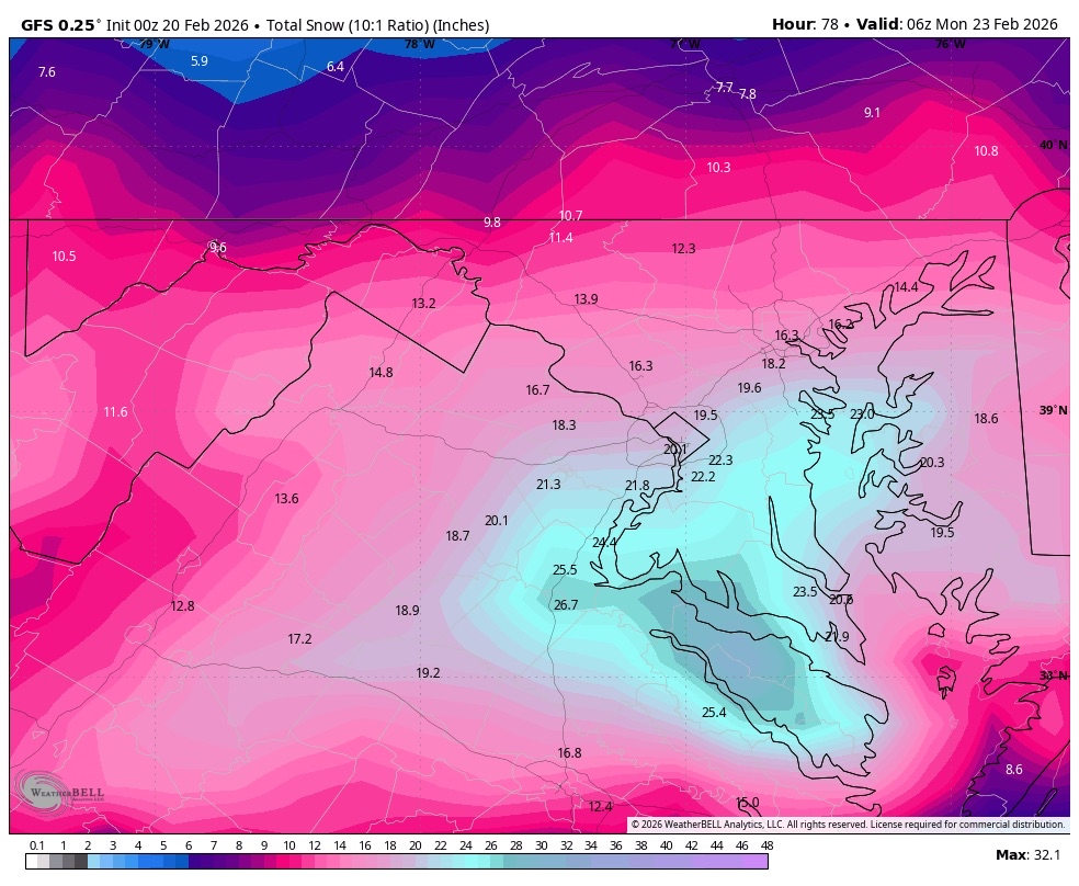
This isn’t quite the final btw I got a lil impatient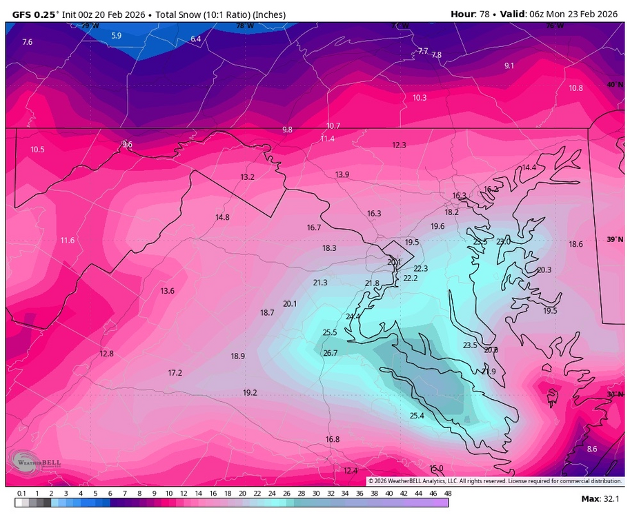
-
Feb 22nd/23rd "There's no way..." Storm Thread
NorthArlington101 replied to Maestrobjwa's topic in Mid Atlantic
Demolished -
Our best posters are out in full force!
-
Feb 22nd/23rd "There's no way..." Storm Thread
NorthArlington101 replied to Maestrobjwa's topic in Mid Atlantic
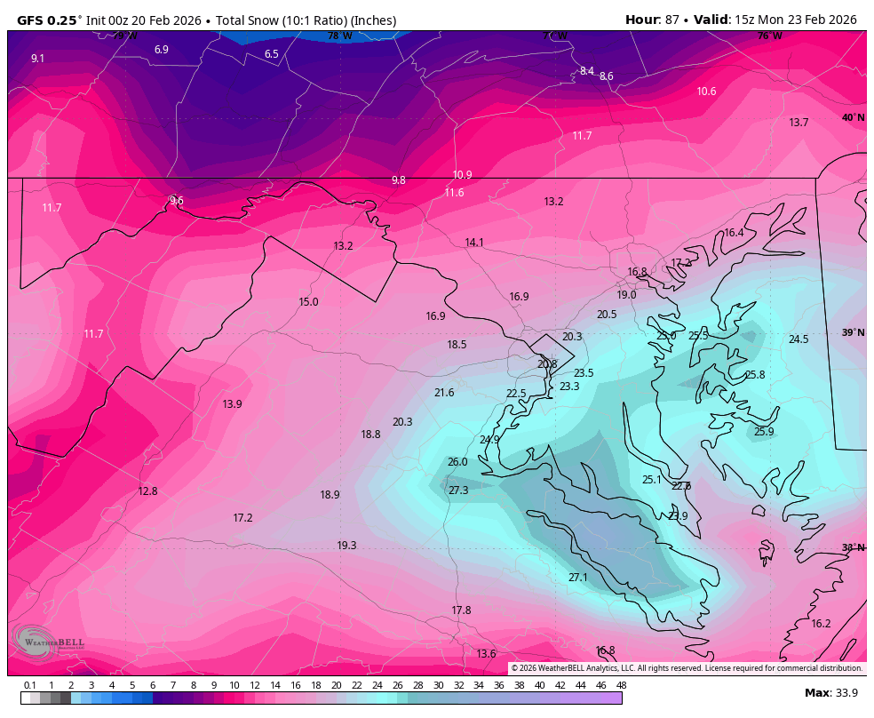
But yes - no member has DCA over 6". To say the GFS is on a different world is an understatement. Different parallel universe -
Feb 22nd/23rd "There's no way..." Storm Thread
NorthArlington101 replied to Maestrobjwa's topic in Mid Atlantic
EPS really wants the IVT overhead. Get a nickel and dimer on the board even at the 10th percentile. Median looks solid -
Feb 22nd/23rd "There's no way..." Storm Thread
NorthArlington101 replied to Maestrobjwa's topic in Mid Atlantic
Identical to 06z essentially -
Feb 22nd/23rd "There's no way..." Storm Thread
NorthArlington101 replied to Maestrobjwa's topic in Mid Atlantic
IVT gonna look okay on the Euro I think. Looks like DC gets .3” of precip when it should probably be snow -
Feb 22nd/23rd "There's no way..." Storm Thread
NorthArlington101 replied to Maestrobjwa's topic in Mid Atlantic
SV maps look like 1-3” all IVT. Coastal is offshore Boston. So yea -
Feb 22nd/23rd "There's no way..." Storm Thread
NorthArlington101 replied to Maestrobjwa's topic in Mid Atlantic
EURO AI says no.