NorthArlington101
-
Posts
12,475 -
Joined
-
Last visited
Content Type
Profiles
Blogs
Forums
American Weather
Media Demo
Store
Gallery
Everything posted by NorthArlington101
-
this is worse than it being 80 and raining all winter
-

January 2026 Medium/Long Range Discussion
NorthArlington101 replied to snowfan's topic in Mid Atlantic
Exactly how I feel honestly. It’s cool for a day. I guess I don’t want it to be 70 right after but nothing cures the post-storm sadness like something lined up after. -
January 16-18th: Rolling the dice
NorthArlington101 replied to SnowenOutThere's topic in Mid Atlantic
Not to be a jerk about this storm but temps when it snows are awful. Would be pretty for those who could get banded but there are obstacles here. -
I’ve basically given up. Think winter has shown its flavor. It’s cold, it’s dry, it’s not a shutout pattern “atmospherically” but it’s not for us on the ground. Bet we find one more 1-3” event and see this as a could’ve been winter.
-
Halfway to a January shutout!
-
January 2026 Medium/Long Range Discussion
NorthArlington101 replied to snowfan's topic in Mid Atlantic
Nothing he said changed after 3:00am. I’m as annoyed the GFS is trying to fold as anyone, but these are still reasons to consider a general NW trend is possible. Let’s see what 12z does. Still got 3/4 days. -
January 2026 Medium/Long Range Discussion
NorthArlington101 replied to snowfan's topic in Mid Atlantic
Hate to say it but AIFS is a total whiff. Guess I’m awake for the Euro… -
January 2026 Medium/Long Range Discussion
NorthArlington101 replied to snowfan's topic in Mid Atlantic
Pretty sure it’s no dice but better than 12z. Onward edit: ya’ll fast -
January 2026 Medium/Long Range Discussion
NorthArlington101 replied to snowfan's topic in Mid Atlantic
UKIE making the right moves through 72 -
January 2026 Medium/Long Range Discussion
NorthArlington101 replied to snowfan's topic in Mid Atlantic
GEFS is might be a smack down. Already crushing the SE…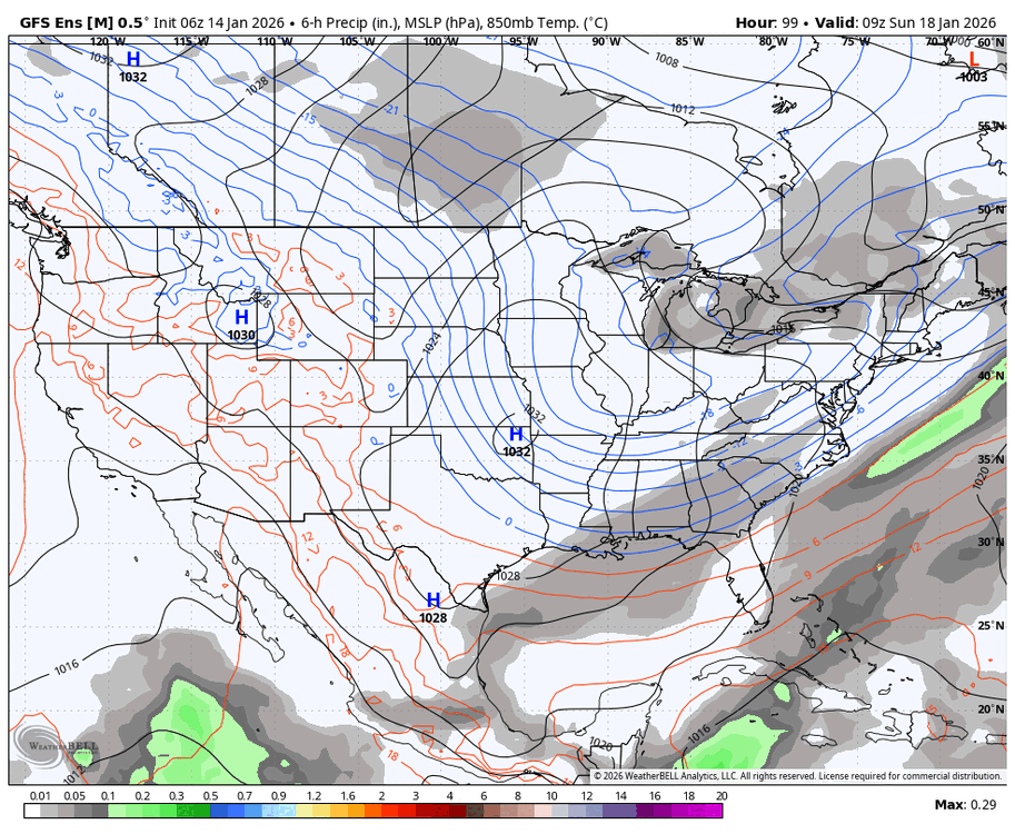
-
January 2026 Medium/Long Range Discussion
NorthArlington101 replied to snowfan's topic in Mid Atlantic
The CMC always matches the RGEM so I’d be shocked if it doesn’t at least make a play for a light event in DC -
January 2026 Medium/Long Range Discussion
NorthArlington101 replied to snowfan's topic in Mid Atlantic
-
January 2026 Medium/Long Range Discussion
NorthArlington101 replied to snowfan's topic in Mid Atlantic
waiting for WxBell to catch up -
January 2026 Medium/Long Range Discussion
NorthArlington101 replied to snowfan's topic in Mid Atlantic
-
January 2026 Medium/Long Range Discussion
NorthArlington101 replied to snowfan's topic in Mid Atlantic
AIGFS pretty solid. Sold.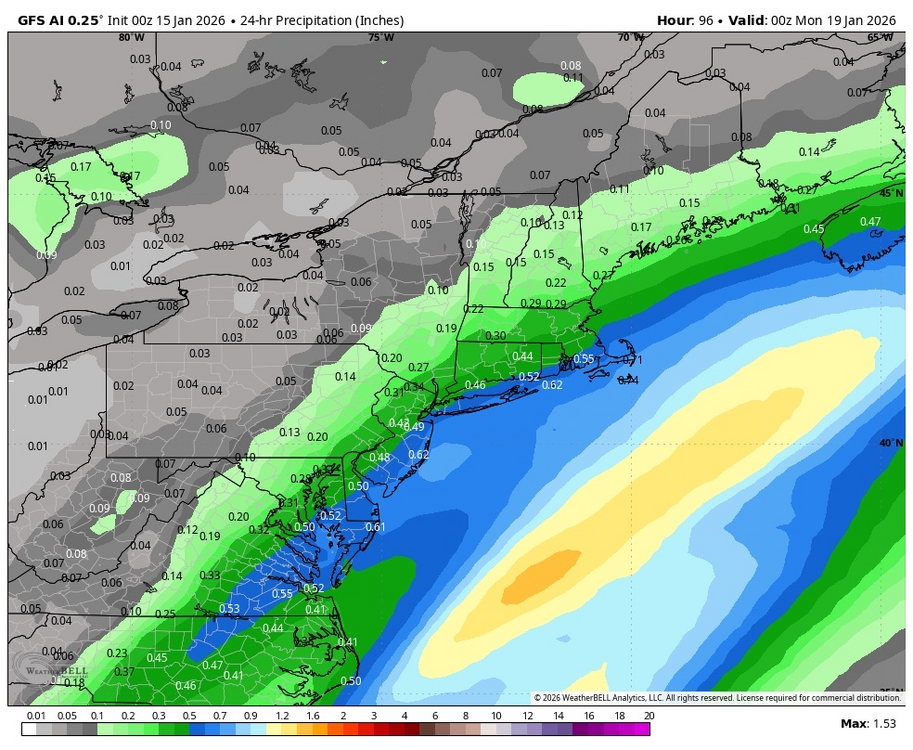
-
January 2026 Medium/Long Range Discussion
NorthArlington101 replied to snowfan's topic in Mid Atlantic
-
January 2026 Medium/Long Range Discussion
NorthArlington101 replied to snowfan's topic in Mid Atlantic
not bad. Includes nothing from earlier in the week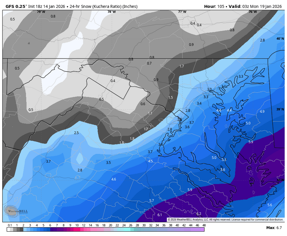
-
January 2026 Medium/Long Range Discussion
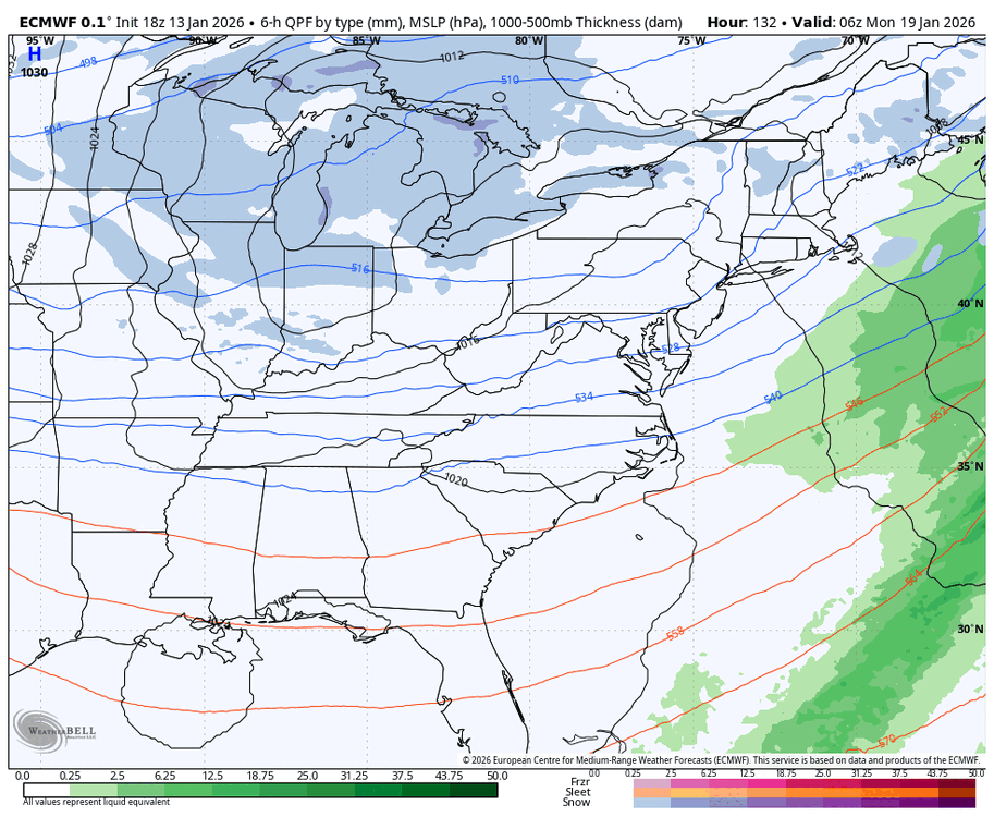
NorthArlington101 replied to snowfan's topic in Mid Atlantic
LP shifts from off OBX to the middle of the Atlantic. Can’t tell if it’s just resolving where to put the low badly or if it’s real. Who knows. Still snows -
January 16-18th: Rolling the dice
NorthArlington101 replied to SnowenOutThere's topic in Mid Atlantic
It’s totally out on Saturday though, which is probably a positive as far as the event goes -
January 16-18th: Rolling the dice
NorthArlington101 replied to SnowenOutThere's topic in Mid Atlantic
Now that I’m leaving to chase some snow suddenly Saturday looks snowier. Aahhh! Hope it pans out for everyone. -
January 2026 Medium/Long Range Discussion
NorthArlington101 replied to snowfan's topic in Mid Atlantic
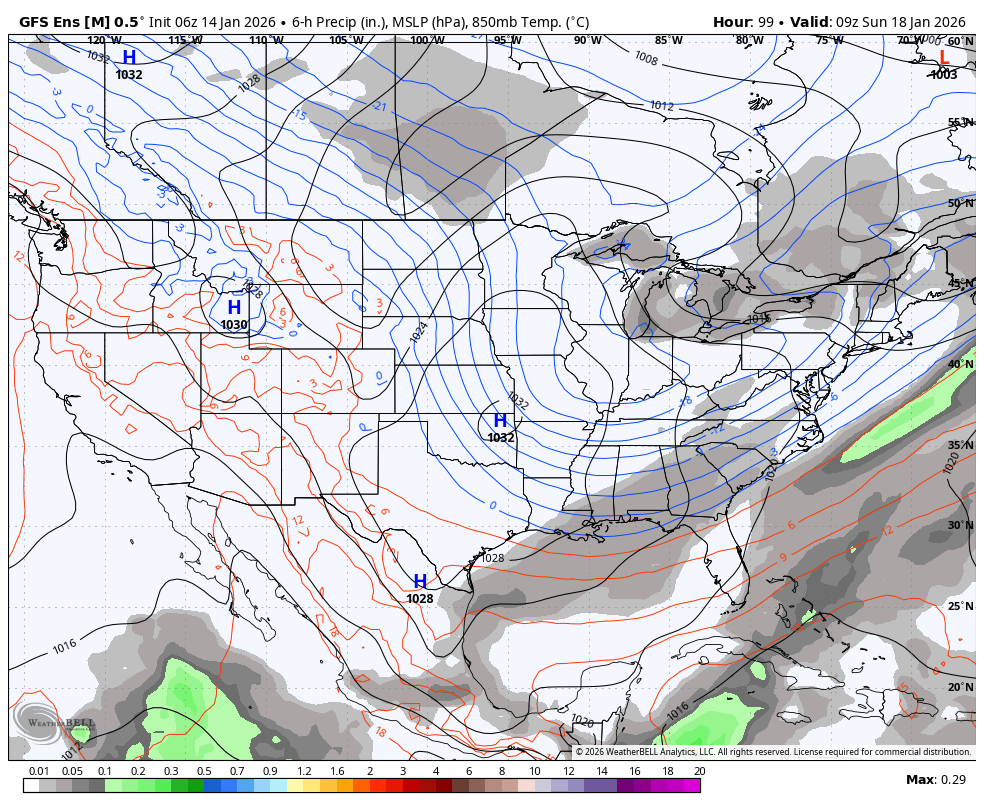
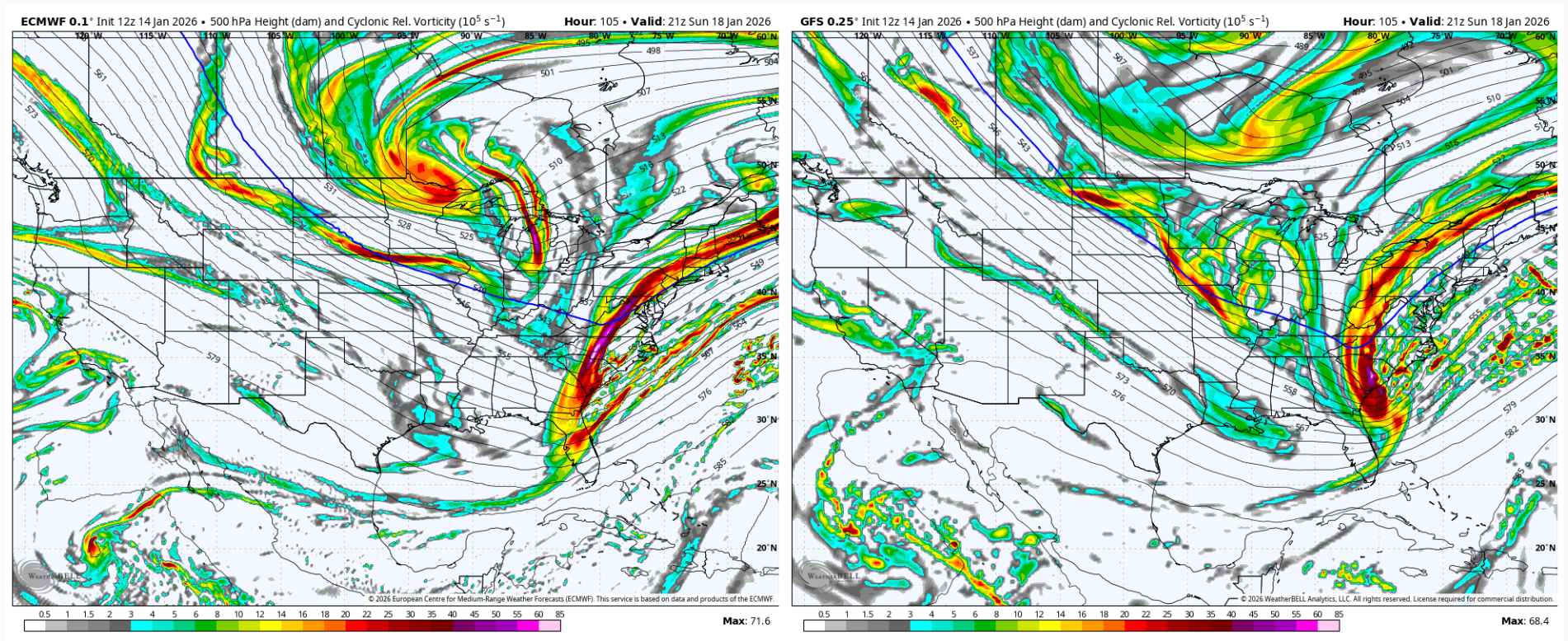
differences at H5 for our timeframe. Not horrifically far apart but obviously not the same. I'll let someone smarter take it from here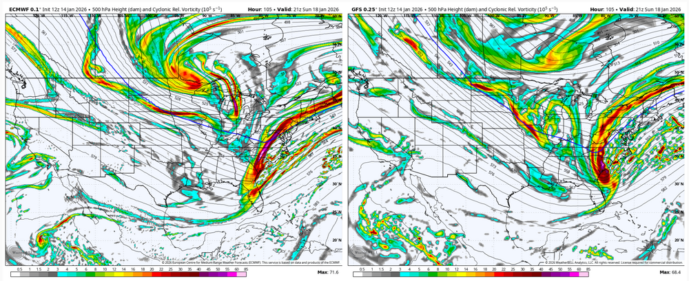
-
January 2026 Medium/Long Range Discussion
NorthArlington101 replied to snowfan's topic in Mid Atlantic
I think you could argue some meager improvements at h5 but agree otherwise. Mostly a noise shift -
Appreciating Each Other/Poster Compliments
NorthArlington101 replied to SnowenOutThere's topic in Mid Atlantic
Great idea! I'll give my early shoutout to @katabatic - who's been working with me to plan a little meetup/snow chase for this weekend. Appreciate his hospitality and look forward to meeting him soon, unless it turns out we're expecting more snow in DC than DCL -
January 2026 Medium/Long Range Discussion
NorthArlington101 replied to snowfan's topic in Mid Atlantic
I know people hate threads for whatever reason but wonder if we need to split off the Saturday stuff. Getting confusing -
January 2026 Medium/Long Range Discussion
NorthArlington101 replied to snowfan's topic in Mid Atlantic
I know I did - I feel like I often forget to check the 6z runs unless people are talking about them here. Looks like a pretty easy high-end advisory event. Too bad it's Day 9