

wishcast_hater
-
Posts
670 -
Joined
-
Last visited
Content Type
Profiles
Blogs
Forums
American Weather
Media Demo
Store
Gallery
Everything posted by wishcast_hater
-
Snowing here - just wet and cold. Running out of pellets for the stove and firewood is all but gone. Gonna have to suck it up and put the HVAC unit to work if it doesn’t warm up soon. Can’t buy flowers till after Mother’s Day otherwise a random frost kills them. I always hated spring more than any other season. .
-
Still waiting…. .
-
That can be said for any weather event. [emoji2357] .
-
It’s all going North. Not much forecast for NYC today.
-
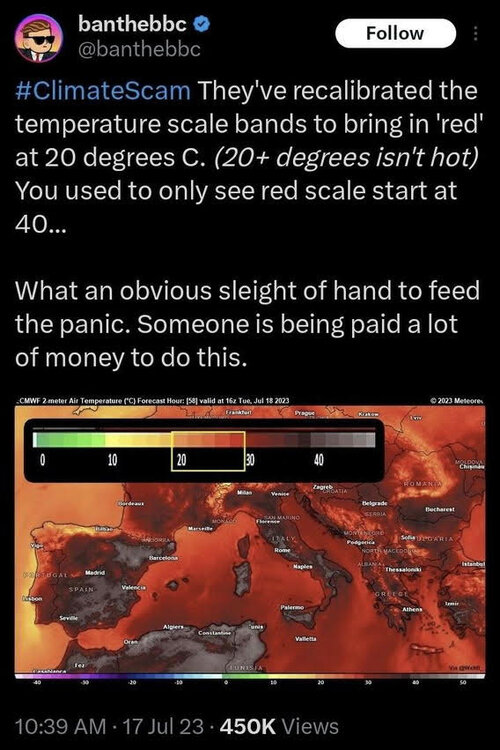
They've recalibrated the temperature scale bands to bring in 'red' at 20 degrees C. (20+ degrees isn't hot) You used to only see red scale start at 40... Can’t stand how misleading these images are. .
-
Now that I hit the hornets nest regarding the religion of climate changte you will tell me how simple I am and how i dont understand the data and how ITS DEFINATELY happening and the science is settled. Save your breath.
-
What nonsense. The data suggests. No one can tell how warm it was 500 years ago let alone 24000. Now that I hit the hornets nest regarding the religion of climate changte you will tell me how simple I am and how i dont understand the data and how ITS DEFINATELY happening and the science is settled. Save your breath.
-
Once rain is on the table its a lock
-
 NASA lies. .
 -
Underhanded stuff like this is why people are not buying the "warming climate".
-
I see your 700 miles and raise it to 800.
-
EPAWA just released a video on YouTube less than an hour ago admitting it doesnt look good BUT the 2 pieces of energy are not even in the US and wont be properly sampled until tomorrow afternoon. Finally remembered how to block users. Added Krs4Lfe, the only other member on that list is snowman19.
-
The guy from EPAWA was saying that it’s literally 3 to 4 hour window of energy that’s lagging behind preventing the phase. He isn’t throwing in the towel until the storm comes on shore tomorrow. .
-
OBS-Nowcast Noon Saturday 2/15-Noon Monday 2/17
wishcast_hater replied to wdrag's topic in New York City Metro
Pouring rain 31. Trees and shrubs bending to the ground. Everything covered in ice. . -
This goes out to all who bow on the alter of the technology. The models suck just as much as they did 10 years ago. .
-
OBS-Nowcast Noon Saturday 2/15-Noon Monday 2/17
wishcast_hater replied to wdrag's topic in New York City Metro
Everything encrusted in ice this morning after about 2.5 of snow. As has been the case all year the forecasts have always busted low except once back in December when I got an unexpected 6”. . -
Why bother? just go to the last few and you can see it’s the same song and dance as the entire winter. The south steals our snow, again. .
-
I don’t think I will ever be happy unless we get blockbusters but I know that’s unrealistic. I am happy we have had snow on the ground for the majority of winter - it definitely makes me happy but it’s not deep enough to really have the kids enjoy it. Hopefully tomorrow the models bring the Thursday storm back up here. .
-
OBS-Nowcast Noon Saturday 2/15-Noon Monday 2/17
wishcast_hater replied to wdrag's topic in New York City Metro
Winter Wonderland up here. Pulled the kids around on sleds with the quad. Been snowing steady since 3:00. Having a blast. Helps that we had 3 or 4 inches from the last event that didn’t perform as forecast. If it turns to rain that’s gonna suck cause the ground is frozen solid. Currently 28 and snowing. . -
Here we go with the bs. It’s gonna be LIVE, DIE, LIVE, DIE until consensus. .
-
I guess no none is interested in this storm huh. I figure at least the guys to the North would we talking about it.
-
Total waste of time IMO to monitor this situation until Monday. How many times have we seen this before?
-
-
Maybe some home for Saturday overnight: Eventually, the cyclone over the Great Lakes closes off up to 850-700hPa with the warm nose surging northward and advancing into our southern zones by Sunday morning. This should support a change over from snow to sleet from south to north. Just how far north the warm nose reaches is still uncertain as a secondary coastal low may develop to our south/east which could pinch off the warm nose and maintain snow/sleet p-types longer into the day on Sunday. Should this be delayed, a changeover to freezing rain is possible, especially for areas along and south of I-90 daytime Sunday.
-
For Areas way North: Eventually, the cyclone over the Great Lakes closes off up to 850-700hPa with the warm nose surging northward and advancing into our southern zones by Sunday morning. This should support a change over from snow to sleet from south to north. Just how far north the warm nose reaches is still uncertain as a secondary coastal low may develop to our south/east which could pinch off the warm nose and maintain snow/sleet p-types longer into the day on Sunday. Should this be delayed, a changeover to freezing rain is possible, especially for areas along and south of I-90 daytime Sunday.


