radarman
-
Posts
14,464 -
Joined
-
Last visited
Content Type
Profiles
Blogs
Forums
American Weather
Media Demo
Store
Gallery
Everything posted by radarman
-
thunder here
-
Gotta be a top 3 or 4 worst March Warm when we wanted it cold. Cold when we wanted it warm. And mostly snowless
-
It is low indeed. Also, as of Saturday, was still completely ice covered, at least on the west fork. I was surprised.
-
Like most springs SW is best
-
Hard pass on a 16+hr drive to chase linear mode low topped thunderstorms with fast moving embedded tornadoes. If you even see one you're probably too close. But take the drive out if it and of course
-
Decent snsh rolling through
-
Yeah 25+ degree inversion today in like 700-800 feet. That's a hell of an inverse lapse rate. Is thunderfog a thing?
-
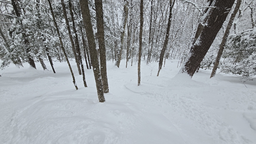
Pack holding nicely. Still 9" in south facing open areas, 13"+ in shady spots. Deeper now than some recent winters ever attained.
-
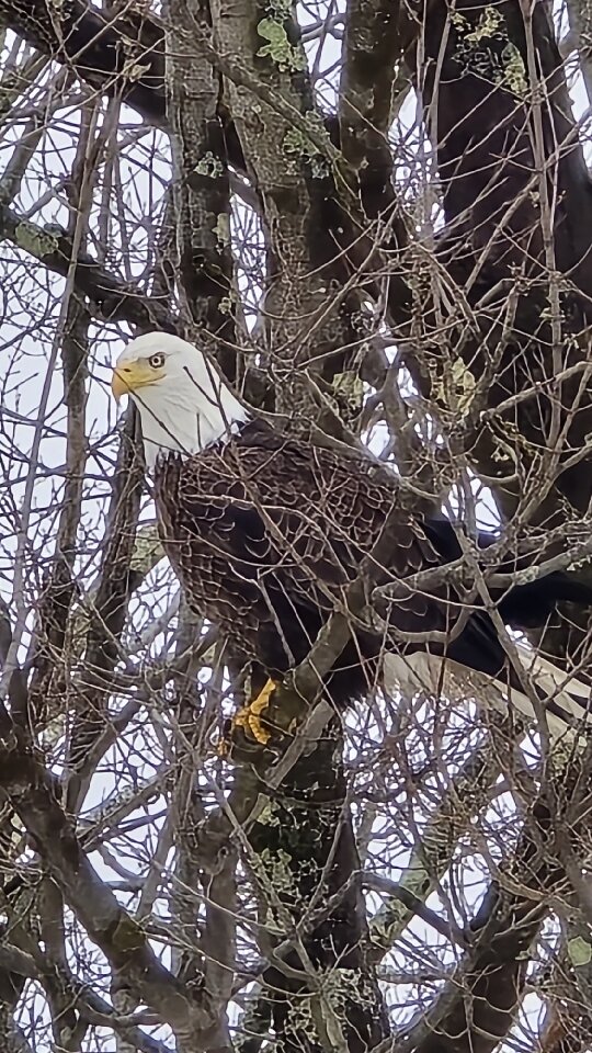
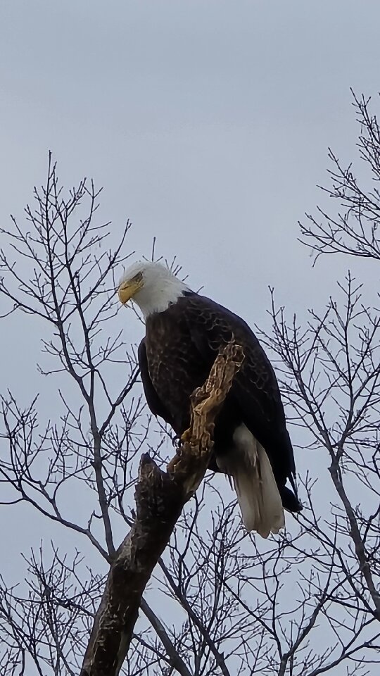
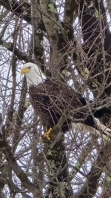
Right in the backyard today, 2 of em-- hung out all afternoon and still here!

_resize_3.jpg.172f5fb91bda73bb2c2bd6f505a24390.jpg)
- 314 replies
-
- 23
-

-

-

-

-
1/16SM fog
-
11.5" avg snow depth in full sun, 15.5" in the shade
-

Texas 2026 Discussion/Observations
radarman replied to Stx_Thunder's topic in Central/Western States
could be a cap bust in N TX, at least til later -
Texas 2026 Discussion/Observations
radarman replied to Stx_Thunder's topic in Central/Western States
WWUS40 KWNS 062041 WWP5 TORNADO WATCH PROBABILITIES FOR WT 0015 NWS STORM PREDICTION CENTER NORMAN OK 0240 PM CST FRI MAR 06 2026 WT 0015 PROBABILITY TABLE: PROB OF 2 OR MORE TORNADOES : 50% PROB OF 1 OR MORE STRONG /EF2-EF5/ TORNADOES : 40% PROB OF 10 OR MORE SEVERE WIND EVENTS : 40% PROB OF 1 OR MORE WIND EVENTS >= 65 KNOTS : 20% PROB OF 10 OR MORE SEVERE HAIL EVENTS : 60% PROB OF 1 OR MORE HAIL EVENTS >= 2 INCHES : 50% PROB OF 6 OR MORE COMBINED SEVERE HAIL/WIND EVENTS : 90% && ATTRIBUTE TABLE: MAX HAIL /INCHES/ : 2.5 MAX WIND GUSTS SURFACE /KNOTS/ : 60 MAX TOPS /X 100 FEET/ : 450 MEAN STORM MOTION VECTOR /DEGREES AND KNOTS/ : 23025 PARTICULARLY DANGEROUS SITUATION : NO && FOR A COMPLETE GEOGRAPHICAL DEPICTION OF THE WATCH AND WATCH EXPIRATION INFORMATION SEE WOUS64 FOR WOU5. -
Anafronts are like the only systems I've ever jacked here. Maybe Jan 2011 was close to a jack
-
2.5" over the course of the day. The first half inch was snow on snow only. Now pinging
-
SN+
-
We've been on the same page of late. It was really good off piste, and protected en piste. Got into Horace's first time this year which is always fun. A little breezy but not nearly as bad as I was expecting.
-
Not sure about Albany in the HV but I feel like parts of the Catskills have done great this year. Esp north western Catskills. I skied Plattekill in Roxbury for the first time this year (love it btw) and have been paying attention to their ski reports and totals. They've gotten hit hard. A number of systems have been driven SSE through there and skirted parts of SNE and CNE moreso than a traditional clipper track.
-
No worries whatsoever.. I know it seems locally high. The overall number of events has been impressive. Even the pennies have added up this year. Will mentioned my area, in far east Btown, is sort of banked up against the western slope of the ORH hills, mild as it may be. But the active northern stream disturbances have suited us pretty well even if the differences might only be a quarter inch here, an inch there or whatever.
-
Unclear what the differences are but here's my event log fwiw. Have pics of a lot of these- 25/26 70" 12/2 6.5" moderate pac s/w, cold air in place, retreating hp, primary near BM, but warm layer pushed far inland. SN->ZR/RN with fluff overnight 12/14 2" weak ocean storm / amplification moving offshore, cold temps. Small flakes fell all morning, bit of an IVT. 6-8" jackpot NYC/NJ 12/23 1" E Canada clipper to the south and west. Minor bust, late burst for White christmas 12/26 5" light. Another clipper focused CT/NY but a nice late burst/mesoband did us good. 1/1 2" beautiful fluff with weak N stream disturbance followed by arctic fropa 1/4 .5" light snows with weak, dry clipper 1/6 .5" more light northern stream action, 2-4" inches up north 1/7 .5" sleet, wet flakes. Followed by some rain. Net loss. 1/17 5" two part clipper, light overnight to dense and sticky. Overperformer 1/18 4.5" an inch dense as moisture streamed in, then 3.5" fluffy overnight mid-level magic from ocean storm 1/21 2" fluff. Surprise northern stream waa event over deep cold air. 4" in N CT/ ORH 1/25-26 22". 2 part HECS with true arctic airmass. Swfe on roids dropped 15" settled, small dense flakes, then 7" on day 2, pure downy fluff. 2/7 4". Northern stream s/w, arctic fropa hooking into distant ocean storm. Cold, high ratio fluff. Overperformed. Crushed NEMA, SECT. 2/10 .5". Northern stream convective blobs on a weak fropa. Bad sounding w/ warmish temps, dry air. Minor bust locally. 2/20 4" heavy. snow to sleet to snow on a swfe, redeveloper. 2/23 8" dense. All time blizzard. SEMA/RI jack. Fringed a bit. Windy, dry snow. 2/25 2" fluffy. Fairly vigorous, fast moving northern stream s/w. Widespread 1-3" in SNE
-
70 after today!
-
Clipper Fires In Wednesday Feb 25 Disco/ Obs
radarman replied to Damage In Tolland's topic in New England
That low level stuff has indeed persisted and we should finish at 2" -
Clipper Fires In Wednesday Feb 25 Disco/ Obs
radarman replied to Damage In Tolland's topic in New England
Ineedsnow give us a signal if torch tiger is holding you hostage -
Clipper Fires In Wednesday Feb 25 Disco/ Obs
radarman replied to Damage In Tolland's topic in New England
The heavy initial burst is moving quickly but ENX suggests a little back filling and lingering low level snows maybe. -
Clipper Fires In Wednesday Feb 25 Disco/ Obs
radarman replied to Damage In Tolland's topic in New England
I called it 8 but included about a half inch predawn