MillvilleWx
-
Posts
5,537 -
Joined
-
Last visited
Content Type
Profiles
Blogs
Forums
American Weather
Media Demo
Store
Gallery
Everything posted by MillvilleWx
-
And then in game 2, everyone sucks again and we flounder the entire game. Team is terrible
-
Got nailed pretty good on my drive home from the night shift overnight. We needed that dousing down in our neck of the woods. Was a nice sight. Could use a few more of those!
-
They do not open the third lane east bound when there is rain or stronger winds, so it's just horrendous timing. They do it to prevent incidents of cars/trucks blowing into the head-on traffic, or hydroplaning into head-on. They also canceled the Bay Bridge Run back in November for the same exact reason. I don't ever foresee them changing that rule either.
-
What in the world? lol
-
That's textbook La Nina right there
-
Despite what the record says, the Orioles are actually worse than they were last year at this time. This is actually very sad baseball. On the flip side, the Nats got some great young talent that actually know how to play baseball and are having fun. I'd be excited to watch these young hitters this season.
-
Long time coming actually. Comes down to ability to handle total computing power. NAM Nest was solid in some ways, but overall it still trails a lot of the guidance with verification. Super compute power can only take so much and we still have RRFS and HRRR, plus the GFS and its intended upgrades. Comes down to the big three: compute power, verification, and money.
-
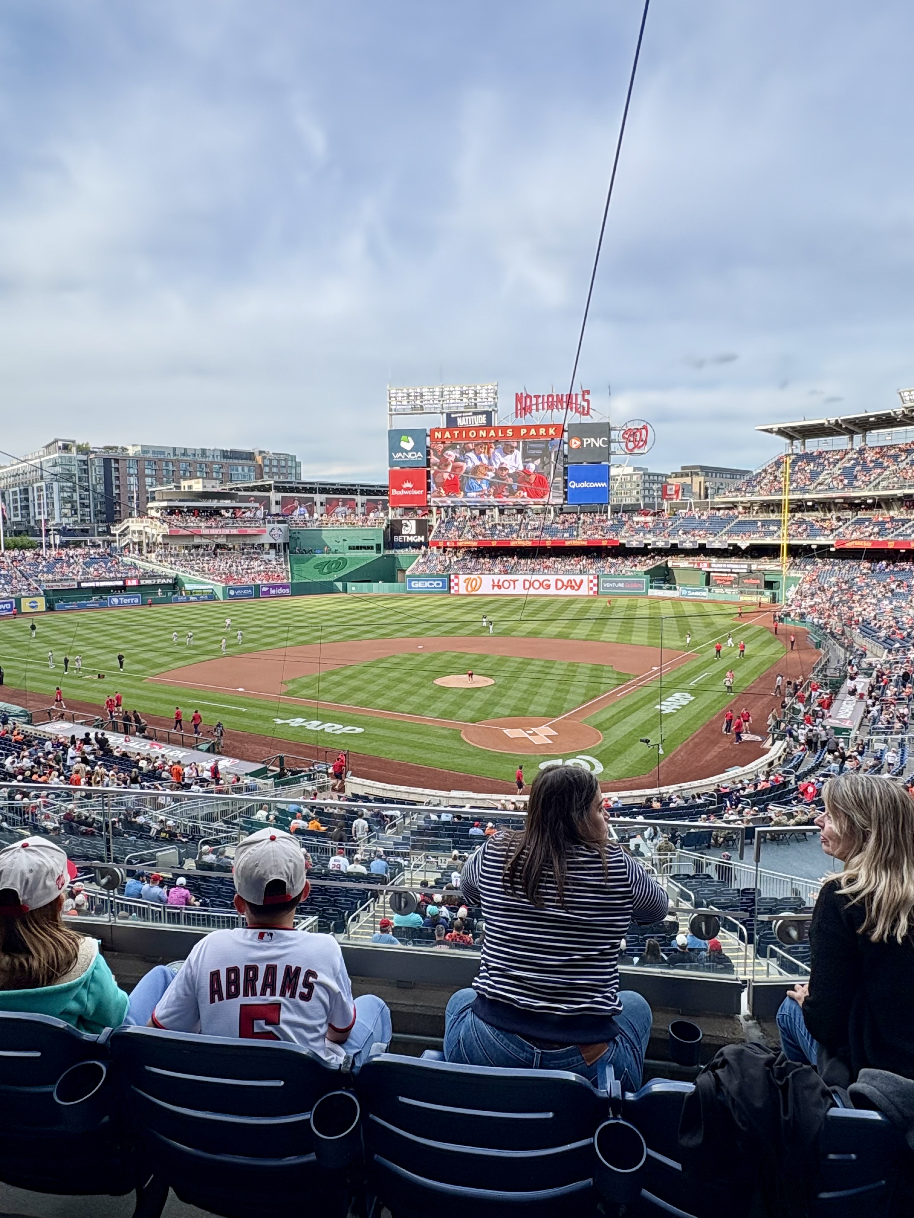
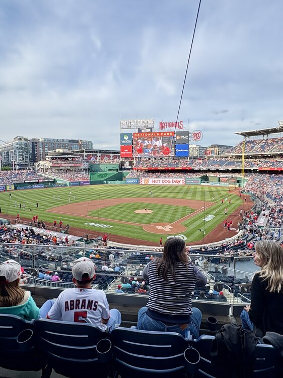
Went to the Os/Nats game last night. Beautiful night for baseball, but obviously a terrible night for guys trying to hit with RISP. Orioles are toast. It's actually one of the more pathetic showings of talent I've seen in awhile. They have a clutch factor of -100. Sad. Despite the outcome for myself, the atmosphere and the time at the game were incredible. Sat club behind home plate which was a phenomenal seat. The Nationals have a great ballpark. Next game will be at Camden Yards, so I'm looking forward to going and staking claim on a good seat with some Boogs and Stuggy's in my facehole
-
You definitely value heat more than me, so I understand your reasoning. I hate the heat. I only like 90+ when I'm at the beach. Otherwise, it's annoying. I do wish we could have more cool and sunny days, but this time of year, cooler weather usually indicates broad troughing or shallow cool from back door fronts. Can't have the cake and eat it too, so I get it. Alas, we also need rain, so getting warm and humid can at least open the door for convection. On to summer I suppose!
-
I'm enjoying the cooler weather because the humidity is on the approach. I will say, it could be warmer, but I know what that means around here....all or nothing. 94/72 or 66/41. No in-between...UGH
-

2026 Mid-Atlantic Severe Storm General Discussion
MillvilleWx replied to Kmlwx's topic in Mid Atlantic
This thread should hopefully spur to life a bit with the overall longwave pattern shifting. Our good friend the WAR will be making a comeback which should open the door with better theta_E advection into the Mid Atlantic. We've been void of persistent southerly flow for a while with the NW flow regime basically a deterrent to any type of warm advection regime in this area of the country.- 1,221 replies
-
- 7
-

-
- severe
- thunderstorms
- (and 7 more)
-
Can confirm. The warm season is ready to come in like a banshee
-
I'm looking forward to seeing how they screw this up /s SHOULD take AJ Dybantsa, but I've heard if we can trade back with Utah, we can grab more draft capital, which they need in the worst way since they have so many holes to fill. AJ just could be a phenomenal talent to forgo this year. 6'9 and is basically NBA ready in a lot of ways. He could play at the 3/4 with AD at the 5 and Trae running point. That is a solid 3 with some of the talent they have already.
-
Not as common in that part of the world, but I put out several of them in my time in Midland. Usually a high desert type deal or Southwest US during monsoon. Been so dry in those parts and high winds carry the dirt and dust off the plains. Quite a setup to get that up there.
-
Excited for this Ravens draft so far. Lane is a nice boundary X with incredible RZ upside given his size. The G from PSU is an absolute beast. I wanted him for weeks since seeing his tape. Oh, and Zion at the edge is a BULL!! Dude can gain leverage and set the edge pretty well. Power rush is a plus. Lacks speed off the edge, so he's limited in that scope, but I like the addition. I hope Mike Green can take the next step. He's the more complete pass rusher between them, but we also have Hendrickson who can teach these guys up.
-
This is the objective analysis page from SPC for upper levels. I don’t have the reanalysis for anomalies off hand, but I’m sure I can do some digging for you in the coming days while on night shifts. I’ll post anything here if I find it!! https://www.spc.noaa.gov/obswx/maps/
-
Cowser just isn't a good major league hitter. His SLG vs off-speed pitches is very bad and he even has trouble catching up to fastballs up in the zone. I hate to say it, but we may have 3 AAAA players on this team that we drafted; Cowser, Mountcastle, and Mayo. Rake in AAA and suck in the majors. Mounty is the only one that has had elite hot streaks, but even those are generally vs one team, the Blue Jays for whatever reason. It happens, but having 3 kind of stings. Ward is fine, but his defense will be a liability, O'Neil is back to never being healthy, Westberg is amazing...but also can't stay healthy. Adley has not been the same since he got hit in the hand June 2024 vs Yankees. Almost feels like he's got the yips or something. It's extremely annoying to see this squad with all this talent be insanely inconsistent at the dish, but tbh, we are one of like 14 teams currently trying to figure everything out and remaining inconsistent. Very few teams have separated themselves from the rest of their divisions in a good way. We have time, but to say it isn't frustrating would be a lie.
-
There better be a derecho afterwards
-
Can I interest you in some, “Absolutely not” with a side of “NO”?
-
Man, idk how you deal with the humidity. When I’m in Florida surrounded by palm trees and stuff, I can live with it for a time. Outside that, just brutal. I am a cold to cool weather fan with a thirst for snow. I probably belong in New England and you belong in South Carolina! That sounds like the perfect spot considering your flavors of weather choices. If you want heat with less mosquitos, move west of 100°W. That’s where I was in Midland located west of that line. Not much in the mosquito department, but it was WAY too dry. One thing about the US is that we have all the weather types you could ever want. Go where life makes you happy!
-
Normal temps this time of year are fantastic with the late March into April sun. I’ll gladly take that right now. I’m ready for spring (NOT SUMMER). I have my limits
-
70°F in my neighborhood by the water. Feels amazing out
-
Delicious! One of my favorite things to do for dinner on Friday nights is prepare a chicken and flank steak and create a little "Build your own burrito bowl" station in the kitchen and everyone can customize. We get Guatemalan crema from the local Hispanic market 2 minutes from the house. On nice days, I'll just walk there. Fresh cut veggies and cilantro lime rice as the base.....incredibly good! Gotta make fresh pico de galo too!!
-
Sausage, egg and cheese McMuffin is my morning road trip breakfast whenever I know I'm about to drive more than 3 hours. The sausage, egg and cheese biscuit from Chick Fil A is also pretty solid, but messier. I liked the Big Arch burger as far as fast food burgers go. It still cannot compare to a local spot, as you mentioned. Those are just another level of good. I'm a sucker for a Monday burger special