Cold Rain
-
Posts
23,935 -
Joined
-
Last visited
Content Type
Profiles
Blogs
Forums
American Weather
Media Demo
Store
Gallery
Everything posted by Cold Rain
-
It has been forever since we've had a -AO or -NAO in winter. Seems like ever since the SAI stuff came out a few years ago, it's been straight positive.
-
That is good to know. Thanks man!
-
Haha I haven't seen that before either. On the other hand, I don't usually spray weeds at 40F. Anyway, saw the article that Fraz posted. Hopefully, it'll work ok when it warms up.
-
Thanks man. Hopefully, it will dissolve back into a liquid again when it warms back up. What a mess!
-
I went outside yesterday to spray some weeds with a new thing of Roundup that I bought from Lowes a couple weeks ago. It's been sitting in my garage since that time. I poured it into my sprayer and it was all clumpy...like a slushy. Anybody know why that is? @mackerel_sky ? Bueller? Anybody?
-
Well the internet if this post. Ould not have possibly been more wrong, unless your long nights are due to nightmares about 10+ January temperature departures. Winter is over (maybe that will work).
-
I've been watching the CFS, GEFS, and GEPS for days now, and they have been showing a pretty good pattern evolving late in their respective runs. Even the EPS has show a decent evolution, albeit it has been steadfast on no -EPO. I have been watching the Euro Op for the last few days at the end of its range, and it hasn't looked very good, for the most part. It's shown pretty much what we're most likely going to see next week...a semi-zonal, fast flow with snapshot, transient cold. And it continues to drop the PV across the pond. The GEFS, GEPS, CFS, and even today's EPS continue to look good at the end of their runs. But this 10-15 day cold pattern that stays 10-5 days away sure is getting old. The fact that we're getting no consistent hints of blocking (AO/NAO) continues to be a problem for us. That doesn't look to change any time soon. The EPO? Maybe. But I'm not excited by the MJO developments over the last couple of days. We need blocking to return. Really bad. I was really excited about entering a colder (as in wintry) pattern over the last few days, but that's waning a little. The 10-15 day cold pattern has got to work inside of that time frame. At least it's going to be a bit more seasonal. It will still be wet, so the rain won't be as warm. Maybe north and western areas can time something out, as well as (just shoot me) the Outer Banks, until we actually get some legitimate cold in here with some staying power. Hopefully, that will take shape earlier in February than later. But I'm kind of disappointed in the way things have developed. But unfortunately, I'm not surprised.
-
Flow is pretty fast with just one wave after another. Progressiveness is likely the main battle to fight here, especially with no blocking. That said, things are pretty close for eastern areas, as it stands right now, many days out.
-
The one next week is really not that far away from getting really interesting really fast. I have a feeling that there are going to be a lot of long nights over the next couple of weeks.
-
Great animation, and it's nice to see from the EPS. Certainly feels like it's just a matter of days before we're tracking a legitimate threat.
-
That is fairly robust. Will be nice when we get to run that for a shorter time frame and see a similar image.
-
Go check out Pivotal or Weathermodels. They are still up. 384 looking lit!
-
The persimmon seed analysis is a pretty good way to go as well. Anyway, it's nice to see hints of blocking in the NAO region. If (big if) it sets up, my guess is that it may not be quite as transient as it appears at present. Long way to go, though. Assuming we continue to see the pattern progress and don't get a rug-pull, you guys are going to do very well. Given how active the pattern has been, and I don't see any reason for that to change, it's only a matter of time. Again, assuming we don't start kicking the can and this is, indeed, the real deal. It certainly looks like it is, for a change. It's been a long time since we've had real cold injected into an active southern stream...at least it has for us down in my area.
-
He cancelled winter a couple of weeks ago, right? How are the GEPS looking?
-
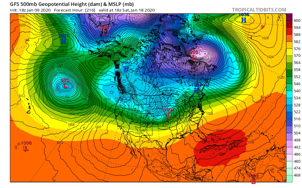
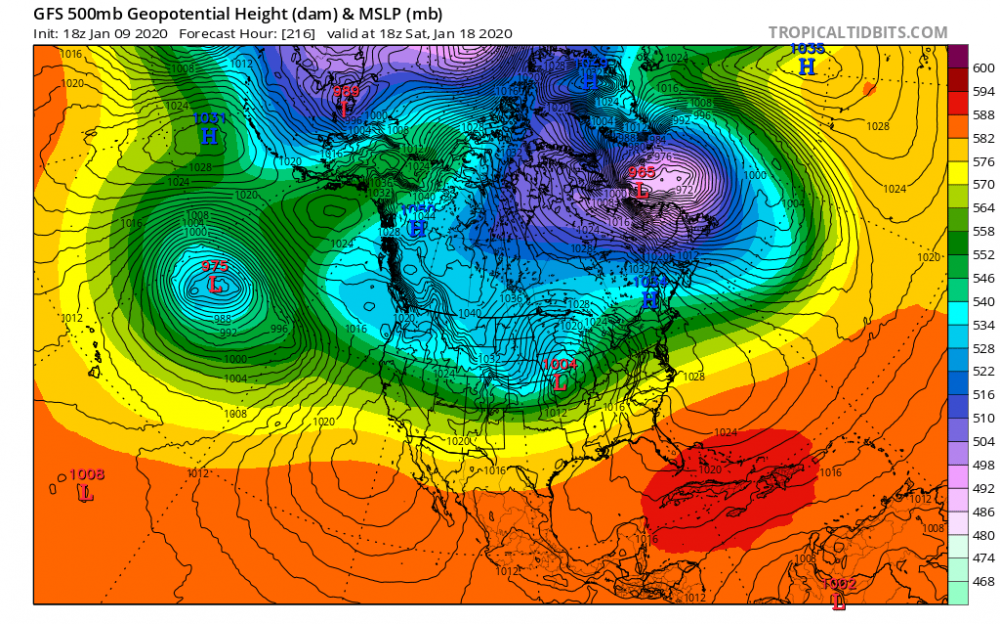
It's best to look at H5 here. This is not a "keep the storm to the south" look. Dont let the surface pressure map fool you. High pressure can look good, but if it's not being anchored or reinforced, it will move out as a storm moves in, giving the illusion that the storm is plowing into a block. If I had a nickel for every time I've heard how a storm can't plow into a high pressure area....
-
Probably about the best I've seen that model look, ever. It usually seems to show warm. Or maybe I only notice it when it shows warm.
-
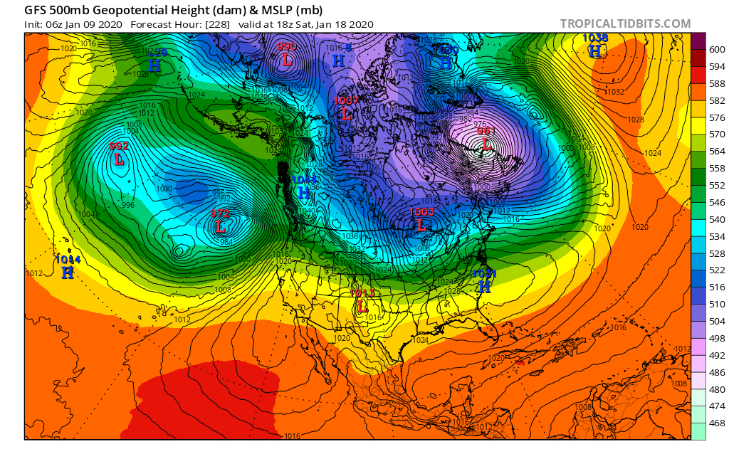
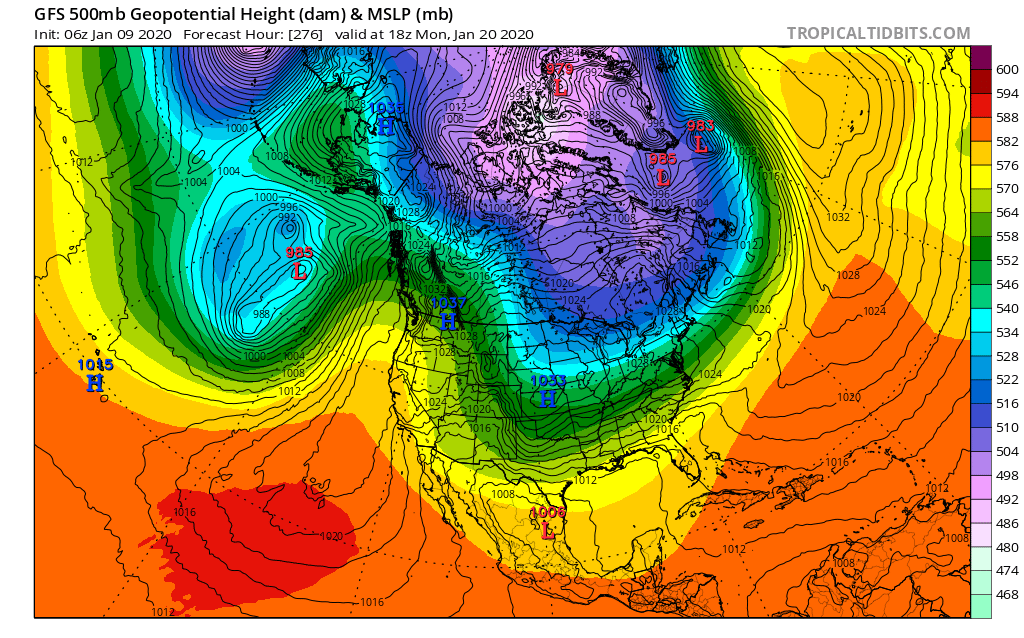
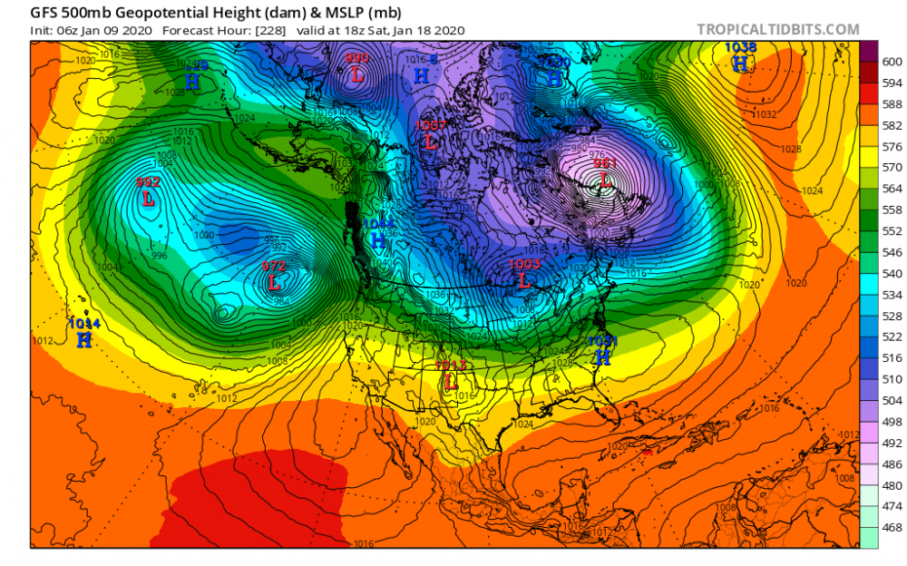
What I'd like to see happen is something similar out west to what the GFS shows: Have that low pinch off underneath the block to its north. The Euro moves in that direction by 240, but it doesn't look as good. It would turn into a good pattern for the east with a continued active STJ and cold highs dropping out of the north.

-
Yeah, the 6z GFS was the first real Op model run in a long time that evolves to a legitimate wintry pattern that would provide several non-trivial opportunities for a widespread winter storm.
-
I live right on the boundary between the two darkest gray zones, right next to the SE county line. Yes, that map makes me want to vomit. It will play out exactly like that too. I don't know why there is always a poleward surge of the snow gradient right in that area. You would think that one time, it would be the inverse, just by the law of averages. But nope.
-
Yeah, the EPS is looking pretty good out in la la land. Gotta look good out there before it gets in here, I guess. Hopefully, we will see several runs back to back with that look and have it actually progress in closer this time.
-
Looking forward to getting past the half-way point in Jan. Should see some signs of life showing up pretty soon. Somewhere near the beginning of H2 January, we'll be tracking our first legitimate threat.
-
What a mess in the long range. All features are still basically opposite of what we want. How does that even happen all the time now? MJO looks like a disaster going into phase 5.
-
It walked away from the big wound up PV over the pole, a little bit, toward the end. Even looks to try to fire up a -NAO.
-
Happy Thanksgiving!!
-
That's awesome. I think our area might crash all the way down to the upper 20s one night. A few days ago, I remember seeing a 12. Models seem like they might struggle by overdoing temps just a little bit in the long range.