

Cold Rain
-
Posts
23,935 -
Joined
-
Last visited
Content Type
Profiles
Blogs
Forums
American Weather
Media Demo
Store
Gallery
Everything posted by Cold Rain
-
I agree.
-
I would think that with the wedge and heavy snow falling, we'd hover around freezing or just below. But there's no way the column is going to be that cold. It will be really interesting if the Euro comes in similar. But I expect it will tick north, just like the others.
-
Looks like the 12z runs have generally ticked north. Was hoping to see southward ticks continue.
-
He LOVES the SREFs.
-
I love this, but there is no way that is going to be right. Oh how I wish, though.
-
Yep, good post.
-
I’ll bet he was! Looks good right there.
-
Ok good deal. Why do you think there won’t be much warming aloft?
-
I think we can all agree that the extended ranges of the NAM are suspect and that it’s snow map on TT is ridiculous. But there is going to be warming aloft here. And it will be warmer and more extensive than the globals are showing. For many in central NC, assuming we don’t have a convection moisture robbing situation (which is possible), there is going to be a lot of sleet and ZR, even back into the Triad and into parts of VA.
-
They're right on the 2-4" line. I can make that work.
-
I threw this down yesterday. Still looks good to me.
-
Nice! Hopefully, that can work itself out before I throw in the towel!
-
What?? It's not rare at all for the models to show 6 inches of snow in Raleigh.
-
And by the way, this is completely typical for winter weather around here. North and west zones are favored and should do pretty well. I believe we've seen peak snowfall maps for this one. For south and eastern areas, we need to see big time suppression 5 days out. We go through this every winter.
-
The Euro did for some areas, but as you can see from the data over the course of the last 12 hours, generally, we're seeing things like weaker highs, slightly north or closer to the coast low pressures, slightly less of a cold air pus, and of course, the snow maps are starting to respond by showing less snow and/or migrating slightly north and west. Not really any better trends today for the south and east edges.
-
Ha they're going to beef it up after models come in with a warmer solution. Still looks to be impactful west of the Triangle, though.
-
We can play around with long range NAM soundings, but the trend in this particular model is to delay and lessen the push of cold air and the strength of the high. There's no question aout that, and it's not good. That doesn't mean it's right. And it doesn't matter if it's exactly right. But if other models continue this trend in one way or another, then we have a problem, assuming you like lots of snow and an all frozen event.
-
You will know they are wrong when ice is forming on the trees in your yard.
-
They would have to do a complete 180 for what to happen? All rain? Not sure anyone is calling for that. It’s hard for me to believe that you have been following the weather for as long as you have and have as much faith in 5 day snow maps as you do, regardless of their consistency.
-
Go to West Jefferson. It’s awesome.
-
It might go ENE for one more frame. I guess we'll never know.
-
I've lived here a long time! We'll check back in on Tuesday and see how I did.
-
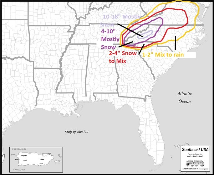
Here's my final call. Ignore areas outside of NC. Just drew a continuous area for symmetry, such that it is.

-
It may prove me wrong this time, but I hate the Canadian model. It has been way north the whole time and is now correcting south. It's just not very good. I'm sure its solution is within the realm of possibility, but I still don't like it.
-
Thanks for posting this. I'm I wasn't out in left field with thinking that. I still think the Pac wave comes onshore a bit stronger than modeled. We'll see.


