TSSN+
-
Posts
4,772 -
Joined
-
Last visited
Content Type
Profiles
Blogs
Forums
American Weather
Media Demo
Store
Gallery
Everything posted by TSSN+
-
Must not know where dc is located
-
Anything is possible with this models anymore. Our early December snow looks like 4-6” a day out and that went to crap real fast inside 12hrs as it shifted nw
-
He’s a weenie
-
That’s a banter thread not an obs thread
-
Think I’ll see more than 4-6” but hey whatever happens happens
-
Storm starts in like 12hrs or less. Is there going to be an obs thread or is this it?
-
It wasn’t
-
Slightly improved.
-

The February 22-23 Late Season Miracle: JV Disco/Banter Thread
TSSN+ replied to bncho's topic in Mid Atlantic
They sending me home! Just got to take some antibiotics for next few days and follow up with my GI doc. -
The February 22-23 Late Season Miracle: JV Disco/Banter Thread
TSSN+ replied to bncho's topic in Mid Atlantic
Getting word they sending me home this evening. Thank goodness. But the communication in this hospital is awful. They told me a GI doc was going to come see me yesterday and they never did, then said today and they never did. Only one doctor stopped by this afternoon and didn’t give me much of a game plan. But nurse came in and said sounds like your going home. I’m like ok??? What’s the game plan here people. lol -
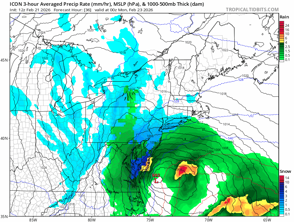
Rgem also better it just moves out the precip too fast but looks like might be some feed back issues an the mlsp lines are all over the place.
-
Icon increased snow across the area by multiple inches. I wouldn’t use that model to make a forecast but seeing it increase is a good sign
-
Icon coming on board

-
Blizzard warning for 2” lol
-
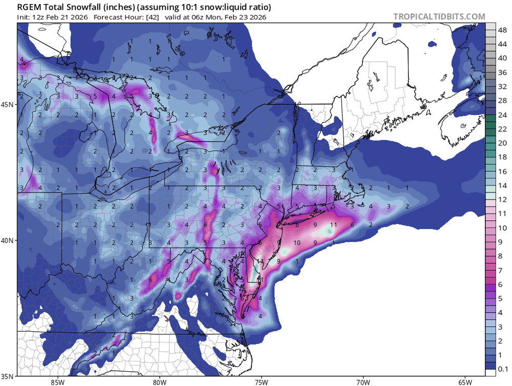
That’s just a snow depth map. I never seen one of those be right.
-
Usually. Some of the biggest storms we have had they had to play catch up. Most storms they go bullish right away we don’t get as much. Like the last storm they were showing 12-15” for most the area.
-
When they go low that’s when we score
-
The hell you talking about
-
Nam is a smoke show, absolutely beautiful
-
Nam is going annular
-
My guess will be out after 3pm there
-
Well then ...WINTER STORM WARNING IN EFFECT FROM 5 AM SUNDAY TO 1 PM EST MONDAY... * WHAT...Heavy snow likely. Total snow accumulations between 6 and 12 inches possible. Winds could gust as high as 40 mph Sunday night and Monday. * WHERE...A portion of central Pennsylvania. * WHEN...From 5 AM Sunday to 1 PM EST Monday. * IMPACTS...The strong winds and weight of snow on tree limbs may down power lines and could cause sporadic power outages. Travel could be very difficult to impossible. The hazardous conditions could impact the Monday morning commute. * ADDITIONAL DETAILS...Uncertainty remains for where the heaviest snow bands will occur. Snow totals could be higher depending on these localized bands. Snowfall at times could exceed 1 inch per hour rates.
-
Got em right where we want em
-
Keep it coming!
-
Ya that’ll change later now the euro just went boom