Boston Bulldog
-
Posts
823 -
Joined
-
Last visited
Content Type
Profiles
Blogs
Forums
American Weather
Media Demo
Store
Gallery
Everything posted by Boston Bulldog
-
 Looks like some lift from 850mb fronto is crashing in to erode the northern extent of the dry slot over CT. IMO this is one of the first signs of how the coastal reflection is beginning to modify the overall structure of the system, which is attempting to consolidate dynamics towards vertical alignment. Looking downstream, BOS and points north should benefit. EDIT: Just missed @ORH_wxman's latest radar update, only further affirms these processes
 -
Higher end totals in EMass will depend on how efficient the ocean enhanced stuff is once this WAA period ends in a couple hours. Given how persistent the fetch has been over the Boston area, I’d say it should produce just fine. I’ve always been a sucker for a good easterly firehose, Mar 2013 remains my all time favorite storm
-
Best rates of the storm thus far right now
-
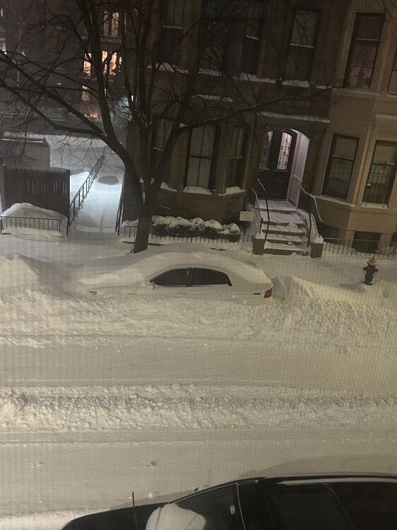
Cars beginning to disappear under drifts
-
Wind whipping up the snow and blowing it everywhere. Full on Blizzard in the South End
-
When does Logan release its totals?
-
Flake size increasing markedly in Boston as bands approach from both east and west
-
“Cory’s in LA! Let’s MECS!” Jan. 24-26 Disco
Boston Bulldog replied to TheSnowman's topic in New England
Rare fetch of precip for sure. Last time I can rememeber such a continental firehose was in early Feb 2022. Ice across CNE and an epic NNE burial thanks to three distinct overrunning waves along a sharp temperature gradient. Precip was stretching back to Texas. Sure synoptics are much more dynamic today, but I thought I would never see an overrunning event of that size for at least a decade. Totally agree with just how incredible the size is of this storm. -
“Cory’s in LA! Let’s MECS!” Jan. 24-26 Disco
Boston Bulldog replied to TheSnowman's topic in New England
This is cope, many such cases of NAM excelling in these set ups. It’s probably a bit overzealous but this is a legit signal -
Awesome, now let us know when the exploding tree temperature threshold is!
-
“Cory’s in LA! Let’s MECS!” Jan. 24-26 Disco
Boston Bulldog replied to TheSnowman's topic in New England
I’d lean Ipswich jackpot but it’s up to the direction of the fetch. You know you’re sitting pretty with historic ocean enhancement patterns -
“Cory’s in LA! Let’s MECS!” Jan. 24-26 Disco
Boston Bulldog replied to TheSnowman's topic in New England
Feel like a dynamic hyperbomb is susceptible to ticks, attenuation, or extreme phasing. This event on the other hand is dynamics at its most simple… we snow and we snow hard. Does sleet get in, maybe? But how much QPF does it sacrifice? a couple tenths max when the DGZ sucks anyways due to dry air perhaps these model runs mean nothing to me. We’re pretty locked in -
“Cory’s in LA! Let’s MECS!” Jan. 24-26 Disco
Boston Bulldog replied to TheSnowman's topic in New England
Highest upside SWFE (due to coastal hybrid characteristics) since 2/2/15? -
Kinda meh in Boston
-
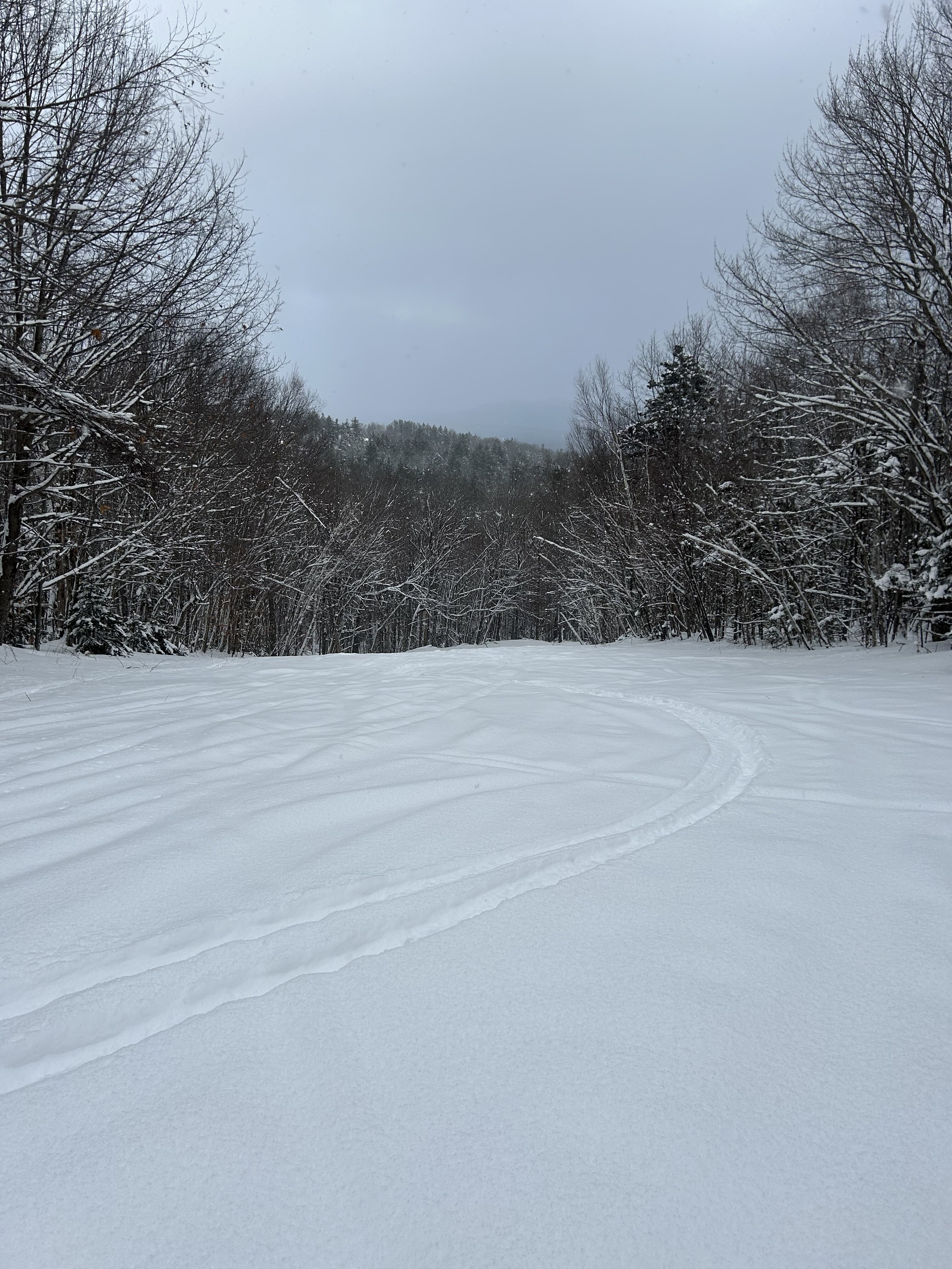
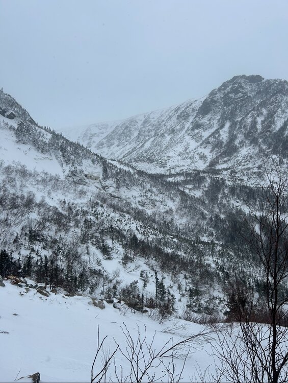
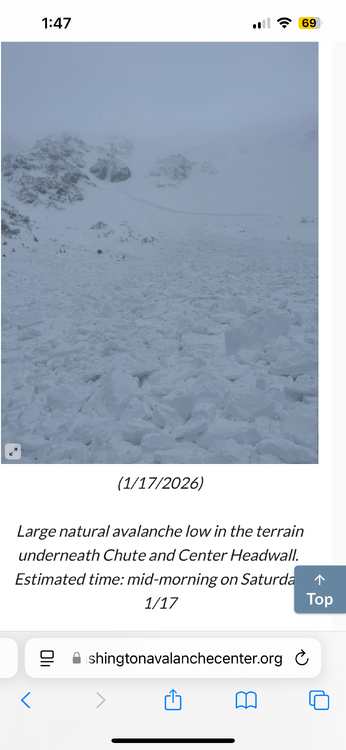
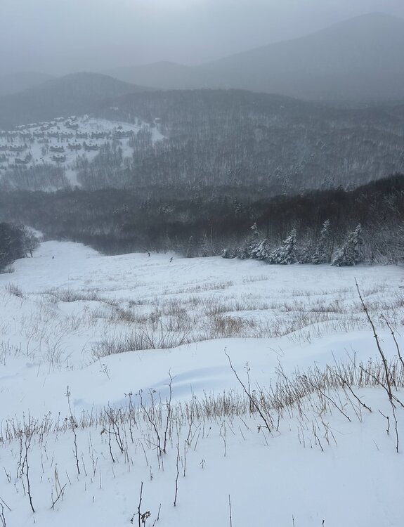
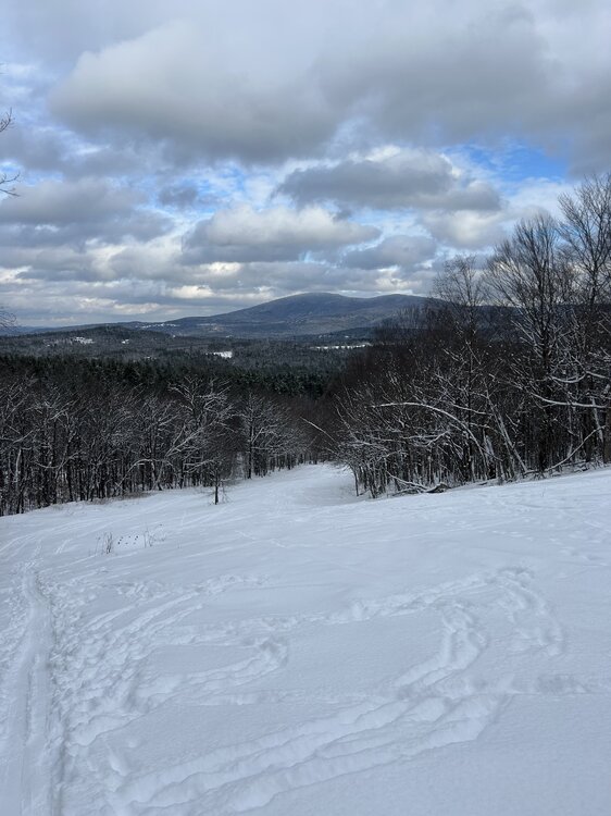
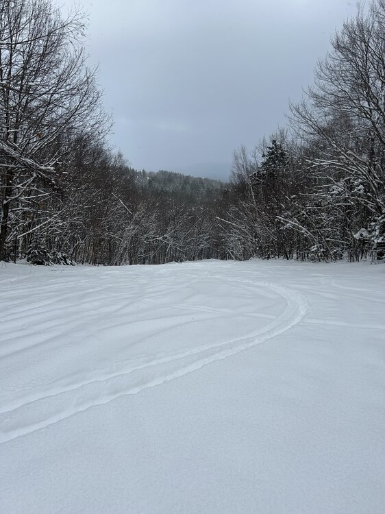
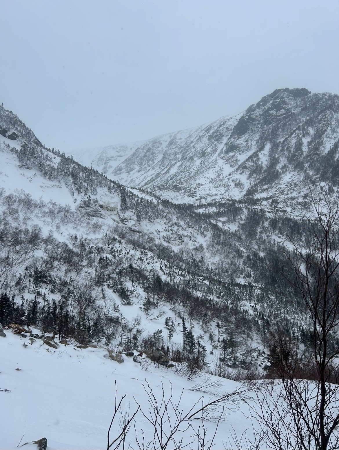
Had the privilege to hop around New England this past weekend to sample the Mid-January snowpack in various locations of NNE and CNE. We began with a Saturday morning in Pinkham Notch. Dreams of a high alpine romp along the eastern ravines of Mt. Washington were quashed early Friday morning as MWAC issued a Considerable avalanche risk for the zone, citing highly reactive slabs present across all easterly aspects. This elevated rating persisted into Saturday, and with new snow loading on the slabs it was clear the snowpack would be touchy. Nevertheless we decided to poke around the zone, test the snowpack in safe locations, and make a judgement call from there. Honestly I knew it was unlikely we would successfully push into the alpine, but saw value in dusting off avalanche safety protocols in preparation for future missions. Arriving at the base of Hillman's Highway we were greeted by hollow "whoomphing" beneath our skins, likely emitting from buried crust collapsing onto further buried layers. This was a sign that not only could a slide occur up high, but it could step down and release older weak layers deeper in the snowpack, generating a much larger avalanche. My party dug a pit, found reactivity, and turned around - opting for a scratchy but safe run down the Sherb. Good thing we turned around when we did. Just to the north Tuckerman Ravine came alive at around the same time, ripping a large natural slide under Chute which stepped across multiple weak layers... exactly what we were worried about. Our backup plan was to investigate the Gulf of Slides, hoping that the SE aspect was shielded from slab formation. Unfortunately Main Gully looked spooky and unskied despite several groups in the area. We backed off once again, this time enjoying a much softer ski on the dynamic GoS trail as a consolation prize. Later in the day the Gulf of Slides underwent a small natural Avy cycle, once again reaffirming our decision making. With the high alpine of the Presidentials a no-go, next up was an even more dangerous endeavor: Killington on MLK weekend Sunday. Ropes dropped for the season on the top pitch of Devil's Fiddle, offering boot top powder and pillowy drops through saplings - a welcome reprieve from the human slalom taking place elsewhere at The Beast. Solitude could be found on Monday. A favorite stash of mine, bathed in views of one of NH's most underrated monadnocks, brought some low angle powder turns (and steeper loud powder) just off the Interstate. A moment of bliss before I too had to join the holiday traffic conga line south back into the flatlands.
.thumb.jpg.3d5c45bd4d7686149bbaac59bc690d75.jpg)
.thumb.jpg.b4dc11481793072dce6e409db15cd5a9.jpg)
- 197 replies
-
- 10
-

-

-
Rise of the Machines: January 18-19 Winter Storm Obs Thread
Boston Bulldog replied to WxWatcher007's topic in New England
ALY radar is quite surprising. That burst of moderate to heavy over the capital district into SVT was poorly modeled -
Rise of the Machines: January 18-19 Winter Storm Obs Thread
Boston Bulldog replied to WxWatcher007's topic in New England
It didn’t initialize correct at all with the first batch or upstream radar -
Rise of the Machines: January 18-19 Winter Storm Obs Thread
Boston Bulldog replied to WxWatcher007's topic in New England
Dumping at Killington. This initial batch got a bit farther north than modeled -
First Legit Storm Potential of the Season Upon Us
Boston Bulldog replied to 40/70 Benchmark's topic in New England
The aggregate trend over the past 24 hours is still really solid. Needs more work, but fast forward from 6z yesterday I’m sure most would take where we are currently -
First Legit Storm Potential of the Season Upon Us
Boston Bulldog replied to 40/70 Benchmark's topic in New England
Man there is going to be an absolutely zonked NAM run within the next 48-72 hours or so -
First Legit Storm Potential of the Season Upon Us
Boston Bulldog replied to 40/70 Benchmark's topic in New England
Longitudinal trends on this will be driven by trough dynamics rather than downstream features -
Brief burst of snow in Central NH. Flipped back to plain rain in New London. 32.9
-
January 2026 regional war/obs/disco thread
Boston Bulldog replied to Baroclinic Zone's topic in New England
If it happens, it will not happen like that -
January 2026 regional war/obs/disco thread
Boston Bulldog replied to Baroclinic Zone's topic in New England
LBSW -
The cold trend continues at 0Z tonight for Saturday night. Net gainer for NNE at this point thanks to the emerging front ender. Don’t look at the cracked out NAM coastal run however, that seems like too much to ask for

.jpg.6d5d8d1a3b19a73d699fa262d2c33471.jpg)

.jpg.03995f17b88a02cb7f1d01d0690fff9e.jpg)