aggiegeog
-
Posts
1,265 -
Joined
-
Last visited
Content Type
Profiles
Blogs
Forums
American Weather
Media Demo
Store
Gallery
Everything posted by aggiegeog
-
Texas/Oklahoma Discussion & Obs Thread 2022
aggiegeog replied to It's Always Sunny's topic in Central/Western States
Agreed, and considering models are always too far north with Arctic boundaries at low latitudes then south trends can be expected in the storm track. -
Texas/Oklahoma Discussion & Obs Thread 2022
aggiegeog replied to It's Always Sunny's topic in Central/Western States
Everything is on the table for a memorable second half of December with many days of subfreezing highs and several snow chances. Upper level forecasts look insane while models have yet to resolve surface weather. One of the best analogs for this pattern is 2/21 as well as 12/83, for sure two of the most severe Arctic outbreaks but it's on the table. -
Texas/Oklahoma Discussion & Obs Thread 2022
aggiegeog replied to It's Always Sunny's topic in Central/Western States
We turn wet and cold for the second half of this month. Plenty of highs in 40s and 50s with a chance or two for frozen precip likely mixed in. -
Texas/Oklahoma Discussion & Obs Thread 2022
aggiegeog replied to It's Always Sunny's topic in Central/Western States
Temps this morning are in the mid 20s to mid 30s across East Texas. Looks like the freeze warning could have been expanded one more row. Hope all were prepared for the cold this morning. A rapid warmup after today in the mid to upper 80s by Friday and this weekend. -
Texas/Oklahoma Discussion & Obs Thread 2022
aggiegeog replied to It's Always Sunny's topic in Central/Western States
Looks like a freeze is possible for non urban areas of North and Northeast Texas Wed morning. -
The north central NM mountains (Santa Fe to Taos) will see the first good snow this week. I'd go with 6 to 12" above 10k. 2 to 6" above 8k. A dusting maybe down to valley floor in Taos area. Peaks further south across NM will also see some snow though amounts will likely be under 4".
-
Texas/Oklahoma Discussion & Obs Thread 2022
aggiegeog replied to It's Always Sunny's topic in Central/Western States
Today's rain bomb along I-20 from DFW through East Texas has been incredible with some locations nearly doubling YTD rainfall in less than 24hr. The Mesquite area is up to around 15", DFW up to over 9" and most of area in the 4-8" range. Perfect storm of systems converging over the area. The heaviest rains are slowing edging ESE. I wont be surprised if someone tops 20". What a way to go from major drought to flooding in a few hours. -
Texas/Oklahoma Discussion & Obs Thread 2022
aggiegeog replied to It's Always Sunny's topic in Central/Western States
Gonna be a lot of sites in Northwest Texas with highs over 115F today. The swath from San Angelo north to Wichita Falls is the epicenter. -
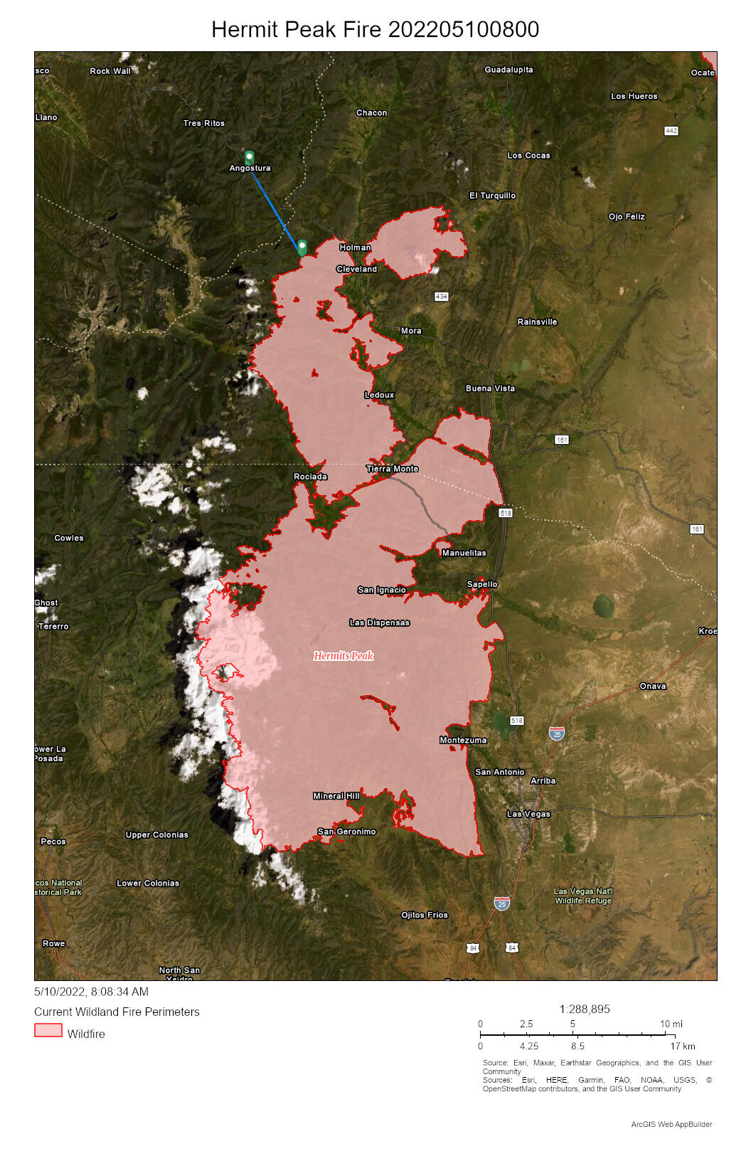
The pictures are incredible and hard to believe. Seeing the smoke columns make 13,000 ft peaks looks tiny is hard to wrap around. And the fact that primary containment lines are being set up 20 miles from the current head of the fire is also. Those mountains are rough and steep with very dense but weak forest covering them. Thankfully not many homes in that area. This fire could easily burn into July or August or at least until it gets to the Taos valley. Imagining the area from Las Vegas to Toas burnt is tough as that is where I have spent my whole life visiting a few times a year.
-
We are in East Texas so too far to do anything but watch. Only one family decided to stay in our neighborhood up there. The fire is now within one creek drainage from our neighborhood. Sadly the neighborhood is fairly wooded so its going to make structure protection difficult. All structures are wood though many have metal roofs so that should help. With humidity levels and wind direction the fire will likely be in our drainage as early as today and good chance by Friday. Of greater concern of course is in the valleys where people live and work and not so much for our vacation homes. The fire will soon be in the towns of Chacon and Guadalapita. It will be pushing towards Angel Fire after that. Praying for the safety of residents and fire personnel, this has been a very hard month for them and there is no end in sight.
-
The Hermit Peak Fire in NM is just 5 miles south of my family's place and winds turn southerly today. The fire has burned over 200,000 acres so far and has been burning for a month already. There are still two months until the monsoon hopefully kicks in. Hopefully winds calm down enough for firefighters to slow the spread and get the helicopters and planes in the air consistently before then. https://nifc.maps.arcgis.com/apps/webappviewer/index.html?id=bfb95b09412840c0afd99626ea2bee4f
-
Texas/Oklahoma Discussion & Obs Thread 2022
aggiegeog replied to It's Always Sunny's topic in Central/Western States
Isolated freeze across East Texas with widespread mid to upper 30s this morning. -
Texas/Oklahoma Discussion & Obs Thread 2022
aggiegeog replied to It's Always Sunny's topic in Central/Western States
NWS confirmed 100mph microburst Monday night in Whitehouse. Lots of damage there. Outside of that winds were in the 50s across a wide swath of East Texas and North Louisiana. -
Texas/Oklahoma Discussion & Obs Thread 2022
aggiegeog replied to It's Always Sunny's topic in Central/Western States
Lots of power outages and some tree and roof damage from last nights line south of Tyler. -
It has been a very rough evening across East Texas with several significant tornadoes and a few more more minor ones. Thankfully they skipped all around me but I did have 3 potential tornadoes within 25 miles around 9 pm. Sounds like Crockett and Gilmer areas got hit hardest. One went right through Tyler but doesn't seem like it was on the ground or at least not in a significant way.
-
Texas/Oklahoma Discussion & Obs Thread 2022
aggiegeog replied to It's Always Sunny's topic in Central/Western States
Band of light snow dropping down along Red River. Areas along and north of I-30 may get a dusting. Watching to see if this develops anymore or if it can drop south much more. -
Texas/Oklahoma Discussion & Obs Thread 2022
aggiegeog replied to It's Always Sunny's topic in Central/Western States
Heaviest snow will be McKinney to Texarkana and points north. Denton and areas west of you will likely see more sleet and miss the heavy snow later today. -
Texas/Oklahoma Discussion & Obs Thread 2022
aggiegeog replied to It's Always Sunny's topic in Central/Western States
NWS continues expanding WWAs south to the I-20 corridor. Amounts should be around half an inch near I-20 with an inch plus possible near the Red River. Before the snow, light rain and sleet will fall. The snow will likely come in a quick burst that could quickly cover roads and especially bridges. Other than precip expect cold wind chills all day today. A hard freeze is possible tonight where snow accumulates. -
If I wasn't so busy at work I'd happily trade my dusting I'll get tomorrow in Texas for a couple feet at my family's place south of Taos.
-
Been dumping good in Northern NM this month and another 1 to 2 feet today will make this a very good late winter.
-
Texas/Oklahoma Discussion & Obs Thread 2022
aggiegeog replied to It's Always Sunny's topic in Central/Western States
It still looks like some sleet ending as snow tomorrow north of I-20. Accumulations generally under an inch except 2 to an isolated 3 inches near Red River. -
Texas/Oklahoma Discussion & Obs Thread 2022
aggiegeog replied to It's Always Sunny's topic in Central/Western States
Looks like more sleet and snow for North Texas this morning and showers elsewhere. Friday may bring snow to the northern half of Texas. Saturday morning looks like it may being a widespread hard freeze. -
Texas/Oklahoma Discussion & Obs Thread 2022
aggiegeog replied to It's Always Sunny's topic in Central/Western States
Raining pretty heavy with temps in 33 to 36 range around Tyler. -
Texas/Oklahoma Discussion & Obs Thread 2022
aggiegeog replied to It's Always Sunny's topic in Central/Western States
FTW went with WWA SHV decided on just a special statement. Similar impacts expected though across North Texas and Northeast Texas being low 30s and scattered light rain. Very light ice accretion is possible on elevated surfaces. Can't rule out black ice on bridges. -
Texas/Oklahoma Discussion & Obs Thread 2022
aggiegeog replied to It's Always Sunny's topic in Central/Western States
Another small bullet left to dodge tonight/tomorrow. Nothing major but could see some freezing rain or sleet across Central, North and Northeast Texas if temps come in a touch colder.