aggiegeog
-
Posts
1,265 -
Joined
-
Last visited
Content Type
Profiles
Blogs
Forums
American Weather
Media Demo
Store
Gallery
Everything posted by aggiegeog
-
Texas 2025 Discussion/Observations
aggiegeog replied to Stx_Thunder's topic in Central/Western States
Yep looks like everything suppressed so may even get some sun Tue. I'll give it a closer look later but most models sitting way with Tue. Another wild ride of forecasting winter in TX. -
Texas 2025 Discussion/Observations
aggiegeog replied to Stx_Thunder's topic in Central/Western States
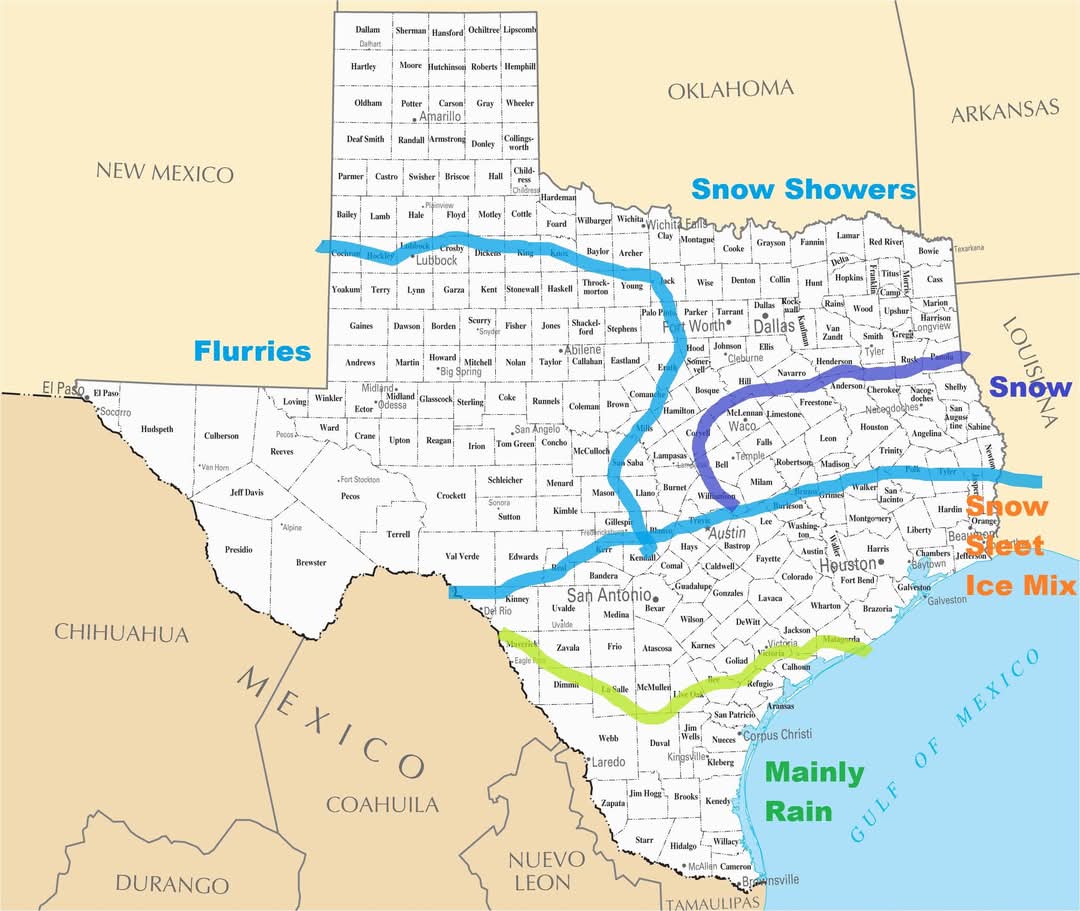
Along and south of I10 tomorrow night looks like rain turning to sleet then ending as snow during the morning hours. Along and north of 190 it should be all snow. The heavy stuff is in the morning after the transition is mostly done so snow could still accumulate significantly assuming the warm nose cools quick enough. -
Texas 2025 Discussion/Observations
aggiegeog replied to Stx_Thunder's topic in Central/Western States
I think much of SE TX will have mainly sleet with this storm. I think the show will be along and north of 190. Areas like Jasper or Lufkin can jackpot with heavy wet snow. Up closer to I20 it will be high ratio snow showers. 21 with a wind chill of 9 this morning here in Lindale. Similar but not as windy tomorrow. Tue will be low to mid 20s. Then mid week lows will be around 20 for areas without snow and low teens for areas with snow. -
Texas 2025 Discussion/Observations
aggiegeog replied to Stx_Thunder's topic in Central/Western States
I think show covered areas will see low teens, especially normal cold spots like Lufkin. I doubt Houston goes below 20 since they won't likely get much snow. Central and North Texas are talking upper teens I expect. East Texas that does not get much snow is likely mid to upper teens. I would not be shocked if someone sees upper singles if ideal radiational cooling can be achieved as low levels will be dry enough mid week to support it. East Texas can get really cold from these NE based air masses. -
Texas 2025 Discussion/Observations
aggiegeog replied to Stx_Thunder's topic in Central/Western States
06Z models hold serve. Still have warm nose questions along and south of I-10. Also questions on if moisture can make it up to I-20 in accumulating quantity. Wherever ends up just north of the transition line could get over 6 inches of wet snow. Below the transition line will be an inch of mix. North of the heavy band will be snow showers which could amount to a few inches of high ratio powder where bands set up. -
Texas 2025 Discussion/Observations
aggiegeog replied to Stx_Thunder's topic in Central/Western States
At this point I am not buying snow for SE Texas. A mix yes but not heavy snow. Heavy snow is possible for Temple to Lufkin. Light powder possible for I20 corridor.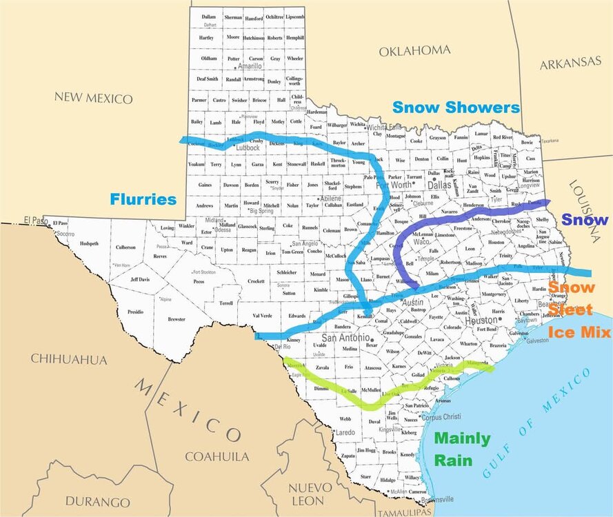
-
Texas 2025 Discussion/Observations
aggiegeog replied to Stx_Thunder's topic in Central/Western States
Gulf lows generally are not good for DFW. Need a upper low out of MX or a strong clipper from CO. Upper lows are more common and they produce wet snow. Clippers can give powder. -
Texas 2025 Discussion/Observations
aggiegeog replied to Stx_Thunder's topic in Central/Western States
18Z GFS coming in too warm so I think you can assume much less ice and better ratios further north. It is the warmest of the models currently. -
Texas 2025 Discussion/Observations
aggiegeog replied to Stx_Thunder's topic in Central/Western States
That area of showers and embedded Tstorms over N TX was not expected, was it? -
Texas 2025 Discussion/Observations
aggiegeog replied to Stx_Thunder's topic in Central/Western States
All good models are a go for snow up to I20. Outliers are UKMET and ICON but I can live with fringe models like that being outliers. The rest have snow of varying intensity up to DFW and Tyler. Ratios along I20 would be in the 15-20:1 range so instant accumulations and high ratios means whatever falls Tue will accumulate quickly. -
Texas 2025 Discussion/Observations
aggiegeog replied to Stx_Thunder's topic in Central/Western States
As has been the trend this season I expect a NW trend over the weekend. If I'm along and south of I10 I'm nervous this becomes a mix event. If the low trends NW or if the N stream vort is stronger then N and E TX could see some powder. -
Texas 2025 Discussion/Observations
aggiegeog replied to Stx_Thunder's topic in Central/Western States
18Z ICON is a reasonable outcome with a missed phase but enough northern stream energy to squeeze out a few inches Tue morning. It takes shockingly little moisture to produce good snow with these temps. As long as we can get above ~0.25" PW we will see snow. If we approach 0.5" PW we will get a big dump. -
Texas 2025 Discussion/Observations
aggiegeog replied to Stx_Thunder's topic in Central/Western States
If ICON and Canadian are close to right then we will see a widespread powdery 6-12" of snow on Tue. Very high ratio snows with a 10k+ foot DGZ and surface temps in the teens. Won't take much QPF to get a good amount of snow. -
Texas 2025 Discussion/Observations
aggiegeog replied to Stx_Thunder's topic in Central/Western States
Whatever falls north of Austin to Lufkin early next week should be powder. South of there will be a transition zone but should be frozen in some form all the way to the coast. Later week another storm but questions on how much cold is left. -
Texas 2025 Discussion/Observations
aggiegeog replied to Stx_Thunder's topic in Central/Western States
0Z Canadian with the casual -15F low Thu. I do think Thu could have ideal cooling and get some into single digits, but sub 0 is so hard though not impossible. -
Texas 2025 Discussion/Observations
aggiegeog replied to Stx_Thunder's topic in Central/Western States
Next week looks bitter cold with some chance of snow south of I-20 and freezing rain nearer to the coast. Many details to be worked out though. -
Texas 2025 Discussion/Observations
aggiegeog replied to Stx_Thunder's topic in Central/Western States
Yep, that was a wild run. plenty of model iterations to go before we know anything but the threat is there. -
Texas 2025 Discussion/Observations
aggiegeog replied to Stx_Thunder's topic in Central/Western States
Getting a bit of snow here now to end things. -
Texas 2025 Discussion/Observations
aggiegeog replied to Stx_Thunder's topic in Central/Western States
31F with freezing rain and sleet here now -
Texas 2025 Discussion/Observations
aggiegeog replied to Stx_Thunder's topic in Central/Western States
Yep so much potential. I think the low up north that is dumping on Amarillo killed it off. -
Texas 2025 Discussion/Observations
aggiegeog replied to Stx_Thunder's topic in Central/Western States
The backside snow looks pretty intense all the way down to near Austin tonight. the snow zone will narrow as you head south though. If it occurs some could end wake up to a surprise covering of snow in the HC and it could give substantial snow up along I-20. . -
Texas 2025 Discussion/Observations
aggiegeog replied to Stx_Thunder's topic in Central/Western States
Well then the Hi Res go crazy with the snow tonight. Basically I am telling people a lot of liquid is going to fall tonight and the temps at surface and aloft if very near freezing, make of that what you will. I could see nothing or 6"+. -
Texas 2025 Discussion/Observations
aggiegeog replied to Stx_Thunder's topic in Central/Western States
At this point over here I dont think we overcome the warmth to switch to accumulating snow. The joys of winter in TX, maybe some light snow showers in the morning. -
Texas 2025 Discussion/Observations
aggiegeog replied to Stx_Thunder's topic in Central/Western States
Not much precip here yet so temps have made it to the mid 30s, they seem to be settling back down a tad now though. 34 now in Lindale. A bit of sleet and some rain showers is all we have had. Models seem to maintain a slight warm nose until tomorrow tomorrow morning, hoping we can get a touch more cooling in mid levels so we can go snow while we have good forcing later today. -
Texas 2025 Discussion/Observations
aggiegeog replied to Stx_Thunder's topic in Central/Western States
For sure at this point spots in DFW proper could see 8", hoping we drop a bit and convert to snow later out east.