aggiegeog
-
Posts
1,265 -
Joined
-
Last visited
Content Type
Profiles
Blogs
Forums
American Weather
Media Demo
Store
Gallery
Everything posted by aggiegeog
-
Texas 2025 Discussion/Observations
aggiegeog replied to Stx_Thunder's topic in Central/Western States
Models this morning really want to hang a chunk of the trough back in the SW which is killing our event. I still think this has a good chance to revert back to previous solutions assuming we can get the trough to eject whole. -
Texas 2025 Discussion/Observations
aggiegeog replied to Stx_Thunder's topic in Central/Western States
NWS has hoisted watches for N and NE TX. Solid snow for N and NE TX. Major ice and sleet with some snow for E TX. -
Texas 2024 Discussion/Observations
aggiegeog replied to Stx_Thunder's topic in Central/Western States
I will disagree with it have a chance to become a rain event. We have a Arctic high pressing cold air into this storm and the storm starts below freezing in most places. All rain is reserved for south of Austin to Lufkin and even along there it could well mix. -
Texas 2024 Discussion/Observations
aggiegeog replied to Stx_Thunder's topic in Central/Western States
We are talking about a very wet storm, key for this forecast is nailing where the column stays sub 32F. For example my location is modelled for >1.5" QPF while the entire column rides within 2C of freezing the whole event from the surface to above 700mb. That would result in a constant fluctuation of precip types so could be talking a 1" elevated surface only ice storm, 3" plus sleet and snow mix or a foot of snow. Tiny variations in the atmosphere will make massive differences. -
Texas 2024 Discussion/Observations
aggiegeog replied to Stx_Thunder's topic in Central/Western States
That is for sure. My current thinking is that the new high over the Rockies will mitigate the WAA at least along and north of the I-20 corridor. Obviously this is E TX and WAA could win out. Around here, I expect light snow Wed night. Intensity will increase while precip becomes more of a mix Thu. By Thu evening/night the trough nears cooling the mid levels for precip to go back to all snow. The snow should end Friday morning as the low passes to the east. Something like >0.1" ice, 1" sleet and 2-3" snow for Tyler area. Maybe .1" ice, 1" sleet and 2" snow for Longview. I live north of I-20 so I am hoping mine leans even more in on mainly snow but gonna be a close call. -
The upper low path is pretty locked in and has been for days. It will dig into N MX tomorrow before kicking out along the MX/US border. As it kicks out a low will form around Brownsville, TX and travel up the coast. This is a pattern that happens every winter and they rarely go north of models. If anything they tend to be suppressed by the Arctic high pressures over the top of them. Y'all could get some snow out of this as the SW trough merges into the Polar jet. The heavy stuff is related to the Gulf low though.
-
Texas 2024 Discussion/Observations
aggiegeog replied to Stx_Thunder's topic in Central/Western States
I think models are way overdoing the freezing rain threat. yes there will be some but I do not anticipate a big area of freezing rain. a few spots in the Hill Country and Deep East Texas may be the exception to that. For the most part I think this is a rain/sleet/snow event, I do not buy into the major WAA that some models are trying to show. -
Texas 2024 Discussion/Observations
aggiegeog replied to Stx_Thunder's topic in Central/Western States
Temp wise this is not a particularly cold event. Highs in the upper 20s and lows in the teens happens every year. And that cold is just in N TX the rest of the state will have highs in the 30s and lows in the 20s. A big part of the 2021 failure was freezing rain affecting wind farms and I don't see that being a big issue across areas where the wind farms are located. -
Texas 2024 Discussion/Observations
aggiegeog replied to Stx_Thunder's topic in Central/Western States
We are now within range of the higher res models so we should start to get a better idea on the details of this event. They are showing less WAA and light precip during the day Wed ahead of the main event. They will soon be in range to see the main event. -
Texas 2024 Discussion/Observations
aggiegeog replied to Stx_Thunder's topic in Central/Western States
I think DFW is is safely in the cold sector and should stay all snow. Maybe isolated outages where heavy snow brings down weak limbs. Now south of a Waco to Longview line could see substantial icing and have power issues. -
Why? Historically N and NE TX get huge snows from these type set ups. SW trough and coastal surface low with cold air in place equals 6-12" for I-20. OK and AR may get in on this one more than in a typical coastal low event as there is an additional lobe of energy on the NW side of this one. This is similar if a bit colder version of 2/2010.
-
Texas 2024 Discussion/Observations
aggiegeog replied to Stx_Thunder's topic in Central/Western States
It almost always takes longer than expected to warm up after a big snow. I agree that Sat morning will be in the teens for many. Outside of DFW some may push single digits. There is a little wave on Sat that could drop a bit more freezing precip. Then another storm next week that has snow potential. This is not a one storm event. -
Texas 2024 Discussion/Observations
aggiegeog replied to Stx_Thunder's topic in Central/Western States
Becoming increasingly likely that this is an all time type event for DFW. Definitely a top 10 event for them and maybe a top 3. Those caught in convective bands could see over a foot. -
Texas 2024 Discussion/Observations
aggiegeog replied to Stx_Thunder's topic in Central/Western States
Things look really good for DFW as far as snow. For the Austin to Tyler corridor, things are murkier with temps in question. I still lean towards a minimal warm nose so thinking mainly snow or rain. Still watching for if there is a warm nose for the first part of the storm in that corridor. As the upper trough nears the cold pool aloft should transition things to purely rain or snow. -
Texas 2024 Discussion/Observations
aggiegeog replied to Stx_Thunder's topic in Central/Western States
After a few runs trending away from a phase most models are back to phasing. Its the difference in a cold light rain and a big statewide winter storm. -
Texas 2024 Discussion/Observations
aggiegeog replied to Stx_Thunder's topic in Central/Western States
The morning models have the SW trough missing the PV phase. If that happens next week's snow would not happen as the cold will leave before any moisture arrives. -
Texas 2024 Discussion/Observations
aggiegeog replied to Stx_Thunder's topic in Central/Western States
What's nice about this pattern is we are in a pattern which will supply continued shots of cold and snow into Feb. Some serious cold will be seen with this as we build a solid snow pack all the way down the Plains. -
Texas 2024 Discussion/Observations
aggiegeog replied to Stx_Thunder's topic in Central/Western States
NWS office are now inserting snow into days 6/7. For now they are keeping it south of I-20 where the better moisture will be. -
Texas 2024 Discussion/Observations
aggiegeog replied to Stx_Thunder's topic in Central/Western States
GFS is the most consistent with next week's storm and it is consistently showing a near ideal set up for a nearly statewide significant snow event. -
Texas 2024 Discussion/Observations
aggiegeog replied to Stx_Thunder's topic in Central/Western States
Next week is a beautiful pattern for snow across TX. On edge of an Arctic air mass which sends down waves of cold while still allowing for shortwaves to pass overhead. While this is ongoing a trough digs into the SW USA allowing us to tap into Pacific moisture on top of the Gulf moisture that will be pulled up by surface lows. -
Texas 2024 Discussion/Observations
aggiegeog replied to Stx_Thunder's topic in Central/Western States
Temps as low as 27 in East Texas this morning with a frost for the whole region. -
Texas 2024 Discussion/Observations
aggiegeog replied to Stx_Thunder's topic in Central/Western States
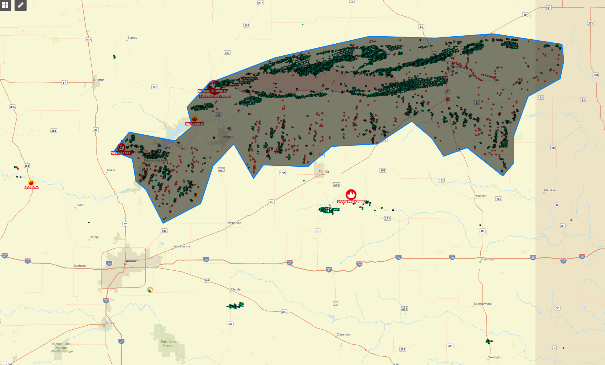
Smokehouse Creek Fire is now over 1M acres. The largest fire in Texas history surpassing the East Amarillo Complex Fire which burned 900k acres. -
Texas 2024 Discussion/Observations
aggiegeog replied to Stx_Thunder's topic in Central/Western States
The fire situation NE of Amarillo is horrible. The main complex consisting of Windy Deuce Fire, near Lake Meredith, and Smokehouse Creek Fire, started near Stinnett and now crossing into Oklahoma, has officially burned over 500k acres. If you measure the the perimeter of hot spots this morning from this complex you get something closer to 1.5m acres. There are other large fires scattered around the Panhandle also.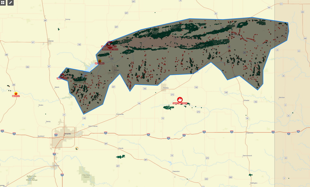
-
Texas 2024 Discussion/Observations
aggiegeog replied to Stx_Thunder's topic in Central/Western States
That early March 2014 In Tyler featured a night of heavy thundersleet followed by a day with highs around 20 and lake effect flurries. -
Texas 2024 Discussion/Observations
aggiegeog replied to Stx_Thunder's topic in Central/Western States
The freezing line is pushing SE it's down along Hwy 80 into Wood County then up towards Texarkana.