

FXWX
-
Posts
834 -
Joined
-
Last visited
Content Type
Profiles
Blogs
Forums
American Weather
Media Demo
Store
Gallery
Posts posted by FXWX
-
-
50 minutes ago, CoastalWx said:
I think they'll be ok. Cape can handle it.
The number of strong wind events the Cape goes through each year gives them lots of practice. There will be issues but probably manageable by Cape standards.
-
21 minutes ago, powderfreak said:
If only we lived at H85.

It's getting tiring living at H500...
-
 2
2
-
-
12 minutes ago, 40/70 Benchmark said:
Yes, exactly. This was my rationale when I cancelled this threat last Thursday.

Yep... excellent... 73 to 75 is the alley I start getting really interested; but even in that zone many more than not find a way to go south and east of SNE. Nice job as usual...
-
 1
1
-
 1
1
-
 1
1
-
-
33 minutes ago, Torch Tiger said:
beers?
?
-
56 minutes ago, 40/70 Benchmark said:
I think most knew deep down this wouldn't be a big deal for the US, but people are bored and some tried to force a square peg into a round hole.
For sure most knew this was a long shot and was fighting decades of hurricane climatology for the Northeast. In the end the usual east fade trend and history will win the day. Once again it proves that the center line of the ensemble spread is usually the best course of action and chasing small numbers of westward members rarely works. For folks looking for a good hit, I understand the excitement of rooting for any favorable members. For forecasters like myself, there are still issues to deal with even if they are confined to immediate coastal plain...
-
4
-
-
3 hours ago, Ginx snewx said:
Command
Ok... wasn't sure where that report was from...
-
41 minutes ago, Ginx snewx said:

what is CMD
-
33 minutes ago, CoastalWx said:
In any case, this is the time when 30–40-mile shifts mean a lot. No argument there.
Yes to this... In this case for eastern MA, even a 20-mile shift will cause significant forecast changes in terms of tree damage and power outage potential... During all storms that have the potential for meaningful numbers of power outages, I'm involved with the pre-positioning of generators for sale to the public at a variety of New England stores (one client with dozens of stores throughout New England). Given limited supply, we try to make a call as to where the greatest numbers of units should be positioned prior to the storm's impacts... But we do not want to leave stores not near the core of the highest threat area without some units, in case there is a shift in the wind gusts forecast... In this case, they have to be at the clients stores by Friday afternoon at the latest. The bottom line, a 20-to-30-mile shift in the track can be very impactful to what I do and the clients bottom line.
-
This has been the summer of Flash Flood Warnings!!!
-
36 minutes ago, 40/70 Benchmark said:
I don't think will be HUGE....the track is going east of us, regardless.
I agree HUGE is likely inappropriate, I also think using the term "Nor'easter" in the thread title was a good way to treat the threat. I have become a bit more interested even though this will be a storm passing east of the Cape, which usually does not get me overly interested. My interest is peaked by the strong winds that continue to be modeled for the 900 / 925 mb levels. This will be gradient driven and the only question for eastern portions of CT/RI and eastern Mass, excluding the Cape, is how efficient is the mixing? Given the progged wind fields, a well-mixed event will lead to pretty widespread power issues given current status of trees (still lots of leaves) & very wet ground surfaces in eastern sections of SNE, eastern CT/RI/inside the 495 corridor of Mass. So, no major hurricane hit, but still solid hit for Cape Cod and coastal eastern Mass... Disruptive wind gusts for interior eastern portions of SNE, "IF" mixing become efficient. If we do not see decent mixing then this will end-up pretty meh for anyone away from the coast.
-
2
-
-
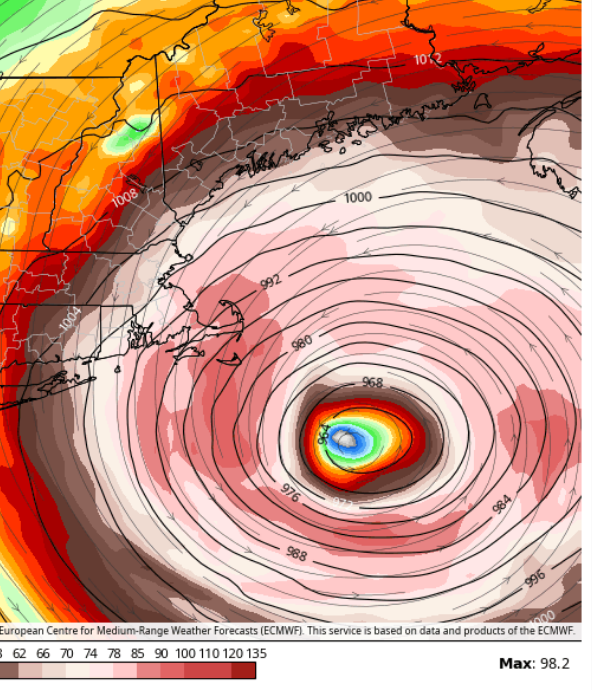
Very impressive 900 mb wind field at 12z Saturday; euro...
-
4
-
-
1 hour ago, Damage In Tolland said:
Not making a forecast 5 days out . What I see now in terms of huge gradient .. warm day and cold aloft.. it seems 50+ is possible for most locations . Need to see what slp is Fri morning
At this time, I would stick close to 40-45 gust range until confident of 925 mb winds and mixing potential. Using some of the basic rules we'd use for predicting strong winds on the backside of nor'easters is the way to go. I remember Gustav and it's not a bad analog if mixing continues to look good. Given saturated ground surfaces and fully leafed out trees, issues will arise if we see consistent winds 40+. Assuming it has started it's transition when it approaches the latitude of the Cape, I think the strong wind expansion due the gradient tightening will make into at least eastern CT... more uncertain further west. Still pieces of the puzzle to figure out.
-
2
-
-
57 minutes ago, Damage In Tolland said:
Yup. Gusts to or over 55 interior. Tried to tell
What do you think is the over / under max wind for Tolland?
-
1 hour ago, CT Rain said:
May have to watch the mixing on the back side of the storm. With a decent pressure gradient if we're able to keep the sun we could see some fairly good northwesterly gusts even inland.
Even the GFS has ~40 knots at the top of the mixed layer back here.
Agree.... For us in CT I'd treat this like mod/strong cold season nor'easter event. Profiles show a decent mixing potential... nothing crazy but some decent gusts... even for the Cape they experience at least a couple systems a year with comparable winds...
-
1
-
-
32 minutes ago, CoastalWx said:
There is truth to what Tip said, a little change here or there is the 00z Euro vs GFS guidance. It won't take much. However, based on what I see.....this is just a bit outside. We really don't have the climo look of a deep H5 trough to bring it closer. I know the Atlantic H5 setup also is unusual, but to me there isn't enough of a capture. NS will take a good hit though.
Agree... It is hard enough to do when we do have a deep trough since many more times than not the timing of the trough is such that it actually acts as a kicker and sends it seaward. We are trying to get a cane to bend back into the New England coast without a perfectly timed strong trough by using the western Atlantic upper pattern to do the trick... Incredibly hard! Impossible no, but boy is that a tough thing to do... most of the time our threats start out south of us at ~73 west and we are hoping they can maintain enough of a north/northeast heading to make it into SNE. Coming north when starting east of 70 west is not a bet I would ever take. It is fun watching the models tease us with a few ensemble members jogging west instead of just sending it seaward, but when push comes to shove these systems almost always (not 100%) trend east in the end... NS is still wide-open for trough though...
-
2
-
-
21 minutes ago, Torch Tiger said:
Can't rule out that peculiar storm that kinda "backs in" , or is bonked by a H P, or dual HP

Not ruling anything out, but just looking for a hint of historical support... always room fota first time?
-
1 hour ago, Typhoon Tip said:
I seem to recall reading once years ago how the 2 weeks before 1938 was described as ‘unusually wet and sultry’
Now granted, sultry is rarher outmoded as a word usage in present culture … But I believe having so many persistent dewpoint days over 70° with daily run-ins with flood warnings and stuff qualifies as similar to that same turn the phrase
Except 38 came abreast of NC... but if you are looking for SNE hurricane action it almost has to have a deep-layered tropical flow precede it... it's just so hard to get a hurricane tracking north from east of 70w to bend back into New England. I would never say impossible, but it's tough enough to get a good hit when a storm comes abreast of NC, nevermind just east of 70w. I haven't had the time to fully research it, but if anyone has map of a similar track that hit SNE, I'd love to see it...
-
1
-
-
32 minutes ago, Damage In Tolland said:
Watch EPS show zero hits
exactly!!!
-
54 minutes ago, CoastalWx said:
This is hilarious
We go from chasing a couple ensemble members every day with no op support to chasing an operational run with almost zero ensemble support!!!
-
1
-
-
Great lightning show across the region last night! When we built our new house 3 years ago, I made sure it had tons of big window areas... my weather office has 2 walls that are essentially all window... here's the view last evening as seen from my office as the New Haven County storm came northward into the Burlington CT area. Had to cut video down but you get the idea...
-
4
-
-
8 hours ago, Ginx snewx said:
Some great guidelines on SNE canes here.
Do you have the link to Box Hurricane guidelines you posted? Looked on BOX webpage but couldn't find it?
-
28 minutes ago, Typhoon Tip said:
If this goes on to do what the GFS general theme over the last 32 cycles ... has been unable to deviate from showing, this will be a first in modeling history that any guidance was so exactingly correct from 13 days lead ... - or whatever/how-many days it's been. That theme has not deviated enough to consider any other track - not really.
Gee, we wonder if it will pull that off when it shows a coastal bomb in the winter.
If the modeled large scale winter pattern was consistently modeled and never really deviated, then I would suggest it would do ok with the expected winter storm. I never saw the GFS or European forecast a large scale pattern developing that would have been favorable for Lee to make a LF...
-
1
-
-
2 hours ago, Damage In Tolland said:
No changes is correct... it never had a decent shot at getting to the coast... chasing individual oddball ensemble members is not what I would call good trends continuing...
-
1
-
-
4 hours ago, WinterWolf said:
Ya…it’s all hype there. If it gets passed 70 west, then he may be on to something…until then it’s just talk.
When it misses to the east, he will say "at least my idea had merit!"
-
1
-


Hurricane Lee--Glorified Nor'Easter or Legit Tropical? Near Miss or Direct Hit?
in New England
Posted
Yep... 38 is almost impossible to envision based on our recent past. My father lived through 38 in central CT and he recalled in very stark terms what the damage looked like...