

FXWX
-
Posts
834 -
Joined
-
Last visited
Content Type
Profiles
Blogs
Forums
American Weather
Media Demo
Store
Gallery
Posts posted by FXWX
-
-
58 minutes ago, Chrisrotary12 said:
I just update the ID in the url.
Thank you... not sure where that link went in my bookmarks, but that's the one... Stay dry; lol
-
Off topic... looking for the link that shows current locations of airport AWOS / ASOS units? Specifically, for KBDR? looking for map or image showing the location of the ASOS at BDR? I used to have a for this info, but can't find it? thx
-
1 hour ago, weatherwiz said:
Figured today would be a misty/drizzly day in places. MOS/NBM profiles across the region yesterday were showing some low visibility numbers with BR in the obs. Sometimes you'll see the NAM go wonky with that stuff but GFS/NBM were like that too so consensus was there.
Agree... I went with low clouds/fog/mist/drizzle with very spotty areas of light rain, but nothing significant for the majority of the region until later this evening; did highlight eastern CT for some decent showers this morning into early afternoon...
-
 1
1
-
-
44 minutes ago, WinterWolf said:
Ahh ok…good to know. I stand corrected then. Thanks John.
No biggie... not terribly important in the grand scheme of things; pretty common occurrence in these low-level saturated setups. Visibility down to a few hundred feet in the hills... at least locally... couple models, especially euro, the nailed eastern CT rain this morning.
-
 1
1
-
-
11 minutes ago, WinterWolf said:
Other than those showers in eastern CT…radar is empty for SNE/CT. We dry today. Let’s see how tomorrow shakes out.
Actually the radar is missing quite a bit of drizzle and light rain... had to take a drive from Burlington to New Britain and back through the Farmington Valley west into the Harwinton area and went through several pockets of drizzle / light rain... none of which were on the radar...
-
2
-
-
This is
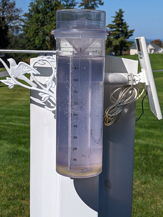 one my stratus rain gauges that had not been emptied since Sept. 23rd...
-
3
-
-
12 minutes ago, Ginx snewx said:
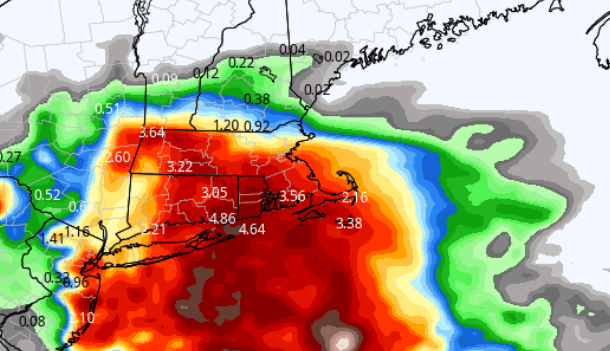
1.94" so far.
4:09"
-
1
-
-
31 minutes ago, Damage In Tolland said:
Hope you’re right . I am very worried about a mild dry suppressed winter
Right now, suppression is not my concern.
-
1 hour ago, Damage In Tolland said:
1.81” here. GFS looks wild tonight
Agree... while heavy / excessive totals are unusually limited in coverage as one would expect, the frequency of these locally excessive events since July has been amazing. And I do think the big storm frequency will carry over into the cold season, especially Jan/Feb.
-
1
-
-
1 hour ago, Damage In Tolland said:
Go go go !
3.30 here in Burlington...
-
1
-
-
20 hours ago, HIPPYVALLEY said:
I guarantee we don’t get anything close to those QPF totals or distribution come January.
Lol... I certainly won't count on it... or we will get it with +10 degree temps at 850 mb
-
2
-
-
Just now, FXWX said:
actually Friday / Saturday period...
-
1
-
2
-
-
13 minutes ago, STILL N OF PIKE said:
What’s 18z euro show for precip Friday
-
1
-
1
-
 2
2
-
-
-
Just now, FXWX said:
Bunnel River in Burlington... 3.69" here...
-
Bunnel River in Burlington... 3.69" here...
-
4
-
-
35 minutes ago, CoastalWx said:
Nam Meh. AWT
Still crushes parts of srn CT but rapid decrease from nrn CT north and east...
Part of that probably has to do with the capture and northwest track of Ophelia into central NC, which greatly limits northeast push of moisture field? I do think there is support for heavy rain zone south of SNE, whether or not it can punch north into southern portions of SNE is up for grabs...
-
1
-
-
41 minutes ago, Damage In Tolland said:
NAM looks nothing like that
Well that's something we will likely say a thousand times over the next 6 months...
-
 1
1
-
-
2 minutes ago, weatherwiz said:
There were 90K+ without power in Maine so it couldn’t have been that meh. I mean meh isn’t going to cause 90,000+ power outages
Probably the most over used term on the board; second to only stein...
-
1
-
-
1 hour ago, Layman said:
Non-meteorologist here (1st post as well...): is there a formula or other standard to define or predict the reduction in wind speed upon encountering land?
For example, if there are sustained 60mph winds at the coastline, are there high-confidence ways to predict/forecast winds 1 mile, 2 miles, 5 and 10 miles inland?
Where I'm physically situated, and from comments I've seen over the years from others, it seems that forecast gusts rarely reach the speeds predicted in the weather apps.
Good question with no simple answer. A few things in play... the friction increase is the most determental item to maintaining the speed you see over the open ocean... also factors such as terrain features, elevation, wide open areas v urban areas, as well as the direction of the wind all play into how much wind speeds will decrease. Another very important factor is whether or not the low-level atmosphere is stable or not... many times the atmosphere near the coast is more unstable (warmer at the surface through the lower levels of the atmosphere) and this allows the very strong winds often found between 2 and 4 thousand feet to mix down to the surface. Many times the inland temperature profile is more stable, warms as you go higher into the 2 to 4 thousand foot level. This prevents the strong winds aloft from mixing down to the surface across inland area. Although high elevations can have an easier time seeing strong winds. The more unstable the lower atmosphere is the easier it is to get the stronger winds to the surface. Most of the time, if I don't think the inland air mass will be unstable (able to mix) I cut modeled land wind gust by 5 to 10% .
-
4
-
-
55 minutes ago, weatherwiz said:
8 AM advisory indicated hurricane force winds extended outwards of up to 105 miles from the center and TS force winds 310 miles. Be curious to see if there is any additional expansion although it's probably likely there will be some. This is a damn impressive field.
The problem with how that is stated in this and all advisories for that matter, is that there is a tendency by some folks to think that means TS winds will occur 310 miles inland when in reality that only implies over the open ocean. Once the landmass interaction occurs that number collapses. I know you fully understand this but I saw someone, non-met, talking about how the wind radii would bring the winds to Albany NY based on the advisory info. The majority of folks know better, but it does crack me up somebody actually uses the wind radii and extend it west or northward over the landmass. It is interesting to see gradient already doing it's dirty work...
-
1
-
4
-
-
2 hours ago, Ginx snewx said:
I have it
Best I've ever come across...
-
50 minutes ago, HoarfrostHubb said:
I’m sure you have read it, but A Wind to Shake the World has some great accounts
I have... I found tremendous old pictorial book of the 38 damage many years ago in a book store in Watch Hill. It's broken into sections by county and there is at least one picture from every town within each county...
-
2
-
-
25 minutes ago, WinterWolf said:
My grandfather said it looked like we were bombed after ‘38…trees snapped and cars flipped over everywhere, and buildings ripped open…this was New Britain, CT.
And nobody knew it was coming…
We grew up in New Britain as well. My father described the roofs of 2 and 3 family houses lift off like and pinwheel to the ground like a Frisbee. In Norfolk, CT at a small historic site there are before and after pictures of the hill sides... almost every oal tree looks like they were just mowed down. In fact, most of the tall oaks across the interior of the state are post 1938...
-
4
-

Octorcher or Roctober 2023 Discussion Thread
in New England
Posted
Burlington