

FXWX
-
Posts
834 -
Joined
-
Last visited
Content Type
Profiles
Blogs
Forums
American Weather
Media Demo
Store
Gallery
Posts posted by FXWX
-
-
7 minutes ago, Damage In Tolland said:
Ones that snow frequently from Dec- Feb and Dec codecs few snow events in Morch
Ok; now we are getting somewhere; this should be easy for you; Just state which ones fit your ranking of A/A+. I'm sure you've had so many during your life so far, they should be on the tip of your tongue... lol
-
2 minutes ago, Damage In Tolland said:
B+
Wow; lol... I need to know which winter seasons you would grade as an A; better yet which ones that you lived through would you give an A+...
-
36 minutes ago, Damage In Tolland said:
We could get 200” over the next 2 months and it will never be a great winter. There’s nothing worse than a short winter or 4-6 weeks.
You can liken it to summer. If you lose June to cold and wet .. all you have are July and August.. And you’ve got in the back of your mind how the late August sun loses its bite.. and there’s posters talking about leathery leaves and the first cool shot across the bow.
How would you classify 2014 - 2015?
-
 1
1
-
-
29 minutes ago, weatherwiz said:
I have to say...I am extremely confused as to what is meant and being discussed when the term persistence is being thrown around.
That's because it's used differently by different folks. If the snow drought continues, some call it persistence regardless of large scale pattern changes. Most mets, including myself, tend to look at the pattern changes, not the outcome when talking about persistence.
-
4
-
 2
2
-
-
11 minutes ago, Go Kart Mozart said:
What is that stuff they're plowing?
Not sure... but when it got warm it disappeared? Still researching..
-
 4
4
-
-
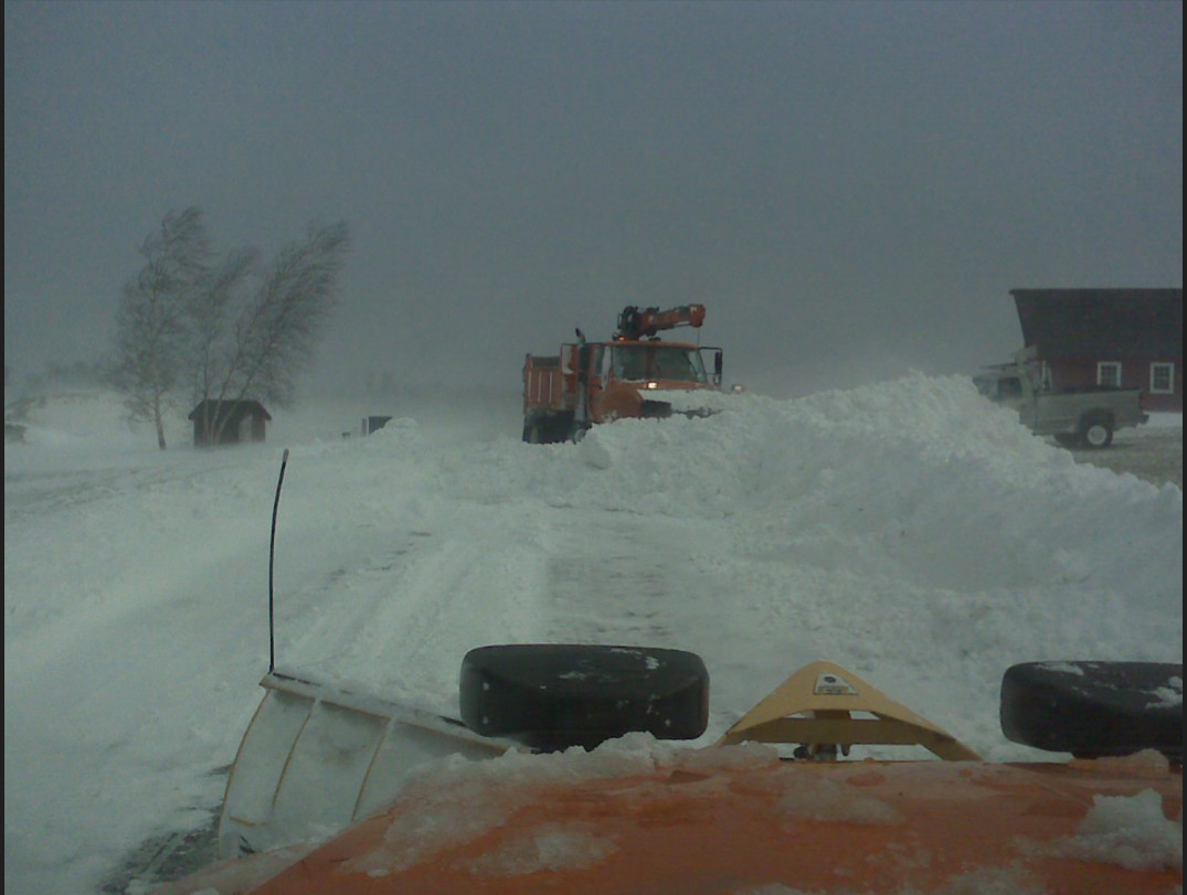
Pic from 12/27/2010... Big-time clean-up operation in Burington, CT...

-
3
-
-
3 minutes ago, Damage In Tolland said:
How is our snower looking for Fri nite/ Saturday?
Was there ever anybody calling fo snow Friday?
-
15 hours ago, ORH_wxman said:
I would have at least given out extra credit points if he said that pattern wouldn’t work in 2023 but instead he just tried to gaslight everyone and say the weeklies were further south than the ‘83 map even though both of them are right in front of us to see.
Jan 1958 also had a similar look. What’s funny about Jan ‘58 is even though it was a pretty snowy month (esp interior), there was a storm late that month which was a perfect benchmark track that was mostly rain. Imagine what the discourse would be in here this season if a late January storm in an El Niño produced a mostly rain event on an ideal track….

Agree... When dealing with many El Nino winters, there are always going to be concerns about the ability to get widespread snows even when you get a great storm track; especially early in the winter. I'm just happy to see storm frequency and intensity continuing since I expect it to pay dividends during Jan & Feb. But, coverage and intensity of cold air masses will be an issue during much of the winter. I'll roll the dice given active storm pattern. While I am in no way looking at 2015 walking through the door, there are too many trends such as trend for Canadian heights like to shift westward, potential for PV disturbance, possible strato warming event and active storm track too dismiss the upside to Jan / Feb period.
-
50 minutes ago, Sey-Mour Snow said:
The blocking is literally in the same exact spot as that weeklies map
Who are you going to believe, ORH or qg-omega? lol... not really a fair fight.
-
1 hour ago, ORH_wxman said:
Yep and this isn’t the forum to debate every attribution. Anyone who has read a lot of the attribution literature when it comes to patterns and actual weather events knows it’s not a very cut and dried part of the science…as say…long term temperature trends. The other stuff is constantly being debated in the literature and often changes.
We’ll tolerate some tangential discussion in here when it’s somewhat relevant to the discussion but there’s a climate change forum if people want to post there.
Agree and apologize for replying within the December thread. I almost always avoid getting into non relevant to thread topic posts... But this time my urge was to respond overwhelmed.
-
1
-
-
5 minutes ago, Cuteirishgirl25 said:
Yes, it’s true. We are in a warm cycle when it comes to the weather especially the oceans and have been for quite some time. but the crap they’re trying to sell you on mainstream media that it’s the human race causing it’ are a bunch of liars. Still waiting for Al Gore to apologize to everyone when his predictions did not come true he said back in 1998 in his book earth in the balance that our kids would only be able to see Snow in textbooks. The conveniently always forget about the medieval warm period.
You are perfect example of what problem is these days with trying to discuss science related topics from climate change to vaccinations. It's never an all or nothing argument. There is no doubt there is a human component to climate trends. The question is how significant??? It is certainly not 100% nor is it 0%. Folks can stick their heads in the sand and block their ears if they want to, but that does not change the facts about climate trends and the likely partial input from humans. On the other hand, those who want to scream and shout that the issue is 100% human caused are just as guilty. My suggestion is read a variety of peer reviewed studies and stop listening to the extremes on both sides. Is will be my one and only post on the subject. I have zero desire to try to convince folks on the extremes of either side of the issue what to believe...
-
5
-
-
-
3
-
-
Great post Tip... But you have to stop using logic and solid meteorological reason, it spoils the negative theme of this thread. Lol...
-
1
-
4
-
 1
1
-
-
9 minutes ago, Typhoon Tip said:
May I just point out a some 'snow logic' here?
Assuming folks equate snow with winter: If one's regional climate receives 90% of their annual snow after January 1, how can December = 30% can kicking? - especially when ( I don't think ) there was much of a forecast from any source that actually needed to be delayed during these last 3 weeks. Maybe I'm mistaken but it seems the consensus was pretty robust on that.
It may be semantics to say 30% in that context, .. .because it sounds more dramatic and the point is really just an emotional one in the first place. I get it. But ... that can be ameliorated by one's expectations being built for the right reason, and/or not forgetting the right rationale in general along the way.
Two aspects:
1, December climo is iffy for snow even as far N as Central NE. Have to get elevation assist/latitude = NNE. That's definitely going to be true as certain changes continue to creep in a subtly force changes that no one is prepared/willing to admit are already happening ( - yes, that back-handedness is intended lol).
2, altho I'm not certain El Nino has been exceptionally well coupled and forcing all this patternization of the hemisphere since mid Novie or whenever, but given how Dec has gone, the evidence is sort of damning. The multi ENSO - linear correlations tend toward milder/rainier Decembers.
I think (1+2)/3 = low expectations and if anything ... a remarkably good fit for what has transpired. Even if #2 is really more of a RONI thing than El Nino, ...meh.. luck favors those that put in the work (usually).
-
1 hour ago, weatherwiz said:
Curious about this...how many people/businesses have generators in Maine?
Actually quite a few. A hardware chain up there is one of my clients and they fly off the shelves every storm... Usually they try to get extra units in the days leading up to an event. But the number of folks without still very much out weighs the number that do...
-
1
-
-
49 mph gust here... 1,160' elevation... 10 meter tower.
-
2
-
-
22 minutes ago, Shaun Curry said:
When I was a Director of Administrative Services for an area school department, winds were a big issue when you had kids waiting at bus stops and a good possibility a school would lose power during the day. You'd rather cancel up front than have an early dismissal, especially with elementary school kids.
Yep
-
5 minutes ago, SnowlieSnowstormson said:
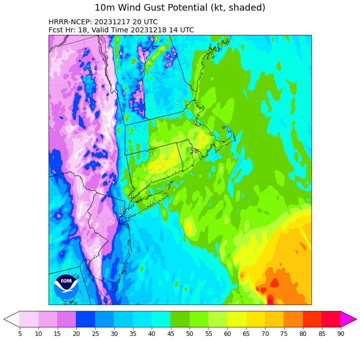 I just checked out the 20z HRRR and saw some eye popping shadings on there for CT… any Mets concerned or are these #s likely inflated?
Just a note since I am already dealing with this issue... If HWW continues for parts of eastern CT, superintendents are going to pull the plug... Especially in heavily wooded towns...
-
2
-
1
-
-
1 hour ago, Damage In Tolland said:
For verification post storm

The blend product certainly should grab attention... Best to treat this as a hybrid tropical system... Using last week's storm as a general baseline for wind but increasing 15 to 20 mph over those numbers.
-
2
-
2
-
-
Just now, dryslot said:
Skimmed thru it just briefly and there's a lot of detailed info on storms of yore in there.
That's the best part...
-
1
-
-
17 minutes ago, WinterWolf said:
We’ll see what 0z looks like…I’m not even close to being sold on anything all that memorable yet.
Well... 0z Nam was right out of Kevin's wet dream!!! Yikes....
-
1
-
-
42 minutes ago, amc said:
Do the heavy rains and soft ground change things? If the ground was frozen I don't think there'd be much concern for damage
It's always a factor... Kinda offset this time of the year by lack of leaves.
-
1
-
-
28 minutes ago, Damage In Tolland said:
NW CAA generally is boring . Trees are trained for that direction. That’s why we love SE screams. Trees can’t handle that direction anything over 50mph. To me, as long this tracks west we are locked 50-60 and a few + CT.. Especially valley east . This area loves SE winds for damage . Nothing is locked.. but a lot of folks are feeling this . Unless it tracks east over the cape.
Agree to disagree... I would confidently predict, far more damage has occurred over the decades during the cold season from gradient driven northwest backside winds than southeast flow events. Especially inland zones. Not trying to Debbie downer and think this one has some decent support...
-
1 hour ago, Damage In Tolland said:
All one needs to do is examine the NAM and GFS soundings. They’ll get it
Of course, that assumes they will be correct, which we all know is frequently not always the case. I do find this system to have a slightly higher chance of verifying; again favoring eastern coastal zones. The last system featured a steadily decreasing threat as we moved from last Friday on into Sunday. Right now, with another 48 hours of trend watching to go, this system seems to be holding a bit more steady... For inland areas, the systems I tend to get excited about are northwest flow events driven by tightening pressure gradients and strong CAA... These southerly flow events are very hard get most inland areas to see widespread damaging gusts... It can happen, but they are relatively rare. I'd watch for any trends of note with the 0z runs... Any backing down would be a red flag....once again the focus is on eastern coastal areas, where if you are not breaking 55 mph, it's not a big deal.
-
2
-
January 2024 -- Discussion
in New England
Posted
https://weather.gc.ca/ensemble/naefs/index_e.html
Here is the link but don 't see the black on white anomaly plot. I used to use that all the time...