

FXWX
-
Posts
1,103 -
Joined
-
Last visited
Content Type
Profiles
Blogs
Forums
American Weather
Media Demo
Store
Gallery
Posts posted by FXWX
-
-
43 minutes ago, tavwtby said:
yeah, tough call just south of the pike region even in higher elevation I think
It's low confidence for a variety of outcomes across most of CT... I'm just happy it's a Sunday event, which greatly lowers my forecasting stress levels...
-
 1
1
-
-
14 minutes ago, Damage In Tolland said:
Thanks for the detailed analysis and post John . As you well know living in a hilltown and especially on a hilltop , many times is not the same as 75% of the rest of the town . Last Feb’s extremely local icestorm was probably the biggest example in my area. Your area higher and in NW CT certainly is favored. 6-9” there seems fairly likely . This area is prone to mid level issues which is why I am erring 3-6” , but admittedly it’s a razor sharp line . The hope is these cold trends continue one more model cycle and we get our valley and S CT folks some good snows.
Agree... I would not dismiss any option at this time... Hoping qpf rates stay healthy Sunday morning...
-
16 minutes ago, Damage In Tolland said:
Are you able to post them here?
No, I do not post my client bases info on social media... but you would find them to be closely aligned with the general sentiments of many of the mets on here; discussing the marginal surface air mass, the very marginal 850 temps during the period(s) of hvy precip and how minute changes during these periods could allow for bursts of hvy wet snow in areas that might right now appear to me mostly in all rain or snow/rain mix zone. I also outlined my thoughts about how portions of Lit cty eastward into the high terrain areas of far western HFD cty, northern Tolland cty & northern Windham cty could over-perform some of the numbers on local media snowfall maps. You're in one of the areas likely to see several inch snowfall amount differences within a very short drive. Much of this is highly dependent on precip rates in some locations being able to sustain an isothermal profile. This would have been such as easy forecast with just a seasonable air mass sfc and/or aloft... My original post was that for some storms it's easier to describe using bullet points and no maps, given the tendency for folks to lock into a number on the map and not reading any accompanying narrative... I think you could be good for 6 to 9???
-
2
-
-
1 hour ago, 40/70 Benchmark said:
As good as any I've seen... bust potential is big across the higher elevations of Litchfield CTY, western Hartford Cty, and northern Tolland & Windam counites... almost no way to show the possible variations across the northern half of CT on any map. I'm right on the Litchfield Cty border sitting at about 1,140' but a few miles away it 200 to 300' of elevation...????
-
2
-
-
5 minutes ago, ORH_wxman said:
In this type of storm it really is.
ORH county above 600-700 feet will be pretty easy. They will snow and amounts will be mostly determined by QPF. Lower down though is a disaster to try and forecast and it’s even worse down in CT where you have to consider midlevel temps being what they are.
I think trying to draw a forecast map for CT is pretty much a worthless exercise in this setup... The elevation changes over short distance alone will kill you... add in the other factors, such as mid-level temp chaos and I think it is just not a viable way to convey the uncertainty...
My course of action was to prepare a list of bullet points (15 of them) listing statements about how variable the conditions may be across the region from the shore to the Northwest Hills and discussing elevation factors, etc... I'm over 1,100 feet at my house, but about 3 miles away it is only 200 to 300 feet...
-
3
-
-
1 hour ago, 40/70 Benchmark said:
Hope you do well there, man....been boned so far.
Did you post a final call???
-
1
-
-
3 minutes ago, Typhoon Tip said:
High was 19 ... not bad, keeping the high below 20
14 here for a high
-
1
-
-
1 hour ago, Typhoon Tip said:
I already think it is ...
It's got overwhelming support now in the ensemble synoptic evolution through that period.
But it's easy to see why it's setting up along the lines of 'synoptic theory'. We have had an active N branch for the last 10 days ( bringing cold to the middle latitude continent and so forth...), and it abandons, but doesn't retreat fully. It really backs out to about 55 N... but this is a base-line confluence result. As the +PP structures and moves by to the N, it's going to have to instantiate an isentropic lifting interface where the return flow around the oriented ... well, fuggit - here
this is the preceding day, the 23rd... you can see the the return flow is likely happening whether this high builds in from the NW or not... *BUT*, because it is... the overrunning is caused by the high obtruding into the region as the return flow is then forced to intersect.
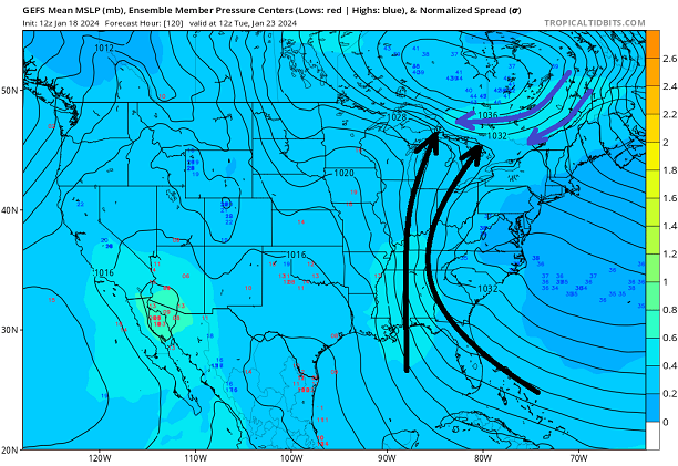
The next day, ... boom- it's really the high pressure that causes this to happen... not a low pressure in this overall scenario.
Nice job Tip... Perfect visualization of this type of a classic swfe / overrunning event. I miss seeing these +pp forced events... Good winters of yore used to feature several of these...
-
3
-
-
6 minutes ago, CoastalWx said:
wtf logic is that?
If this forum starts requiring logic, it might just die... lol ... Not sure you will find that concept in your average Meteorology text...
-
1
-
 1
1
-
-
4 minutes ago, CoastalWx said:
Euro still real paltry on Friday.
Looking at the soundings for CT, it appears the GFS is the only model saturating the low levels; The 18z Euro keeps the low levels relatively dry right through the event?
-
36 minutes ago, Brian5671 said:
God I hope not-I don't care about the torch but we are saturated cannot take another 2 inch rainstorm
I'd be wary, in fact I am very wary about any 2-inch rain events... Not impressed with Thursday / Friday setup, but will give it another day... more interested in next week... we are in somewhat of a pattern change relative to past storm tracks (cutters) and available cold air masses, so I would continue to watch next week closely...
-
2
-
 1
1
-
-
8 minutes ago, STILL N OF PIKE said:
Which one is more accurate picking up warm layers . I’m not saying I buy the 12km nam .
12k would mean decent icing across parts of eastern CT...
-
Mod/hvy snow squall in Burlington, CT
-
1
-
-
Just now, Snowcrazed71 said:
I would love for you to be right, but I'm just not seeing 3-6... Let alone 4-8.
I would keep it in the 1 to 3 or 2 to 4 inch range right now. Would prefer to nudge it up if need be later than have to chop it back...
-
2
-
1
-
-
4 minutes ago, Damage In Tolland said:
Are we thinking the big gusts tomorrow will be embedded in the squalls.. or will they be out ahead of them , and then behind in the CAA?
Maybe some of the stronger gusts will be embedded in the squalls, but there is enough CAA / gradient winds to make it gusty much of the day. Lots of dead trees out there just looking for a reason to fall... Had 2 trees come down in town already when winds started to crank this afternoon... we've had multiple gusts into the mid 30's and just recorded a 40 mph gust.
-
1
-
-
1 hour ago, Typhoon Tip said:
should be a 'scorched earth' policy in effect when people can't control themselves. hard to believe these are 30 40 50 ... 70 year-olds we're talking about but oh well.
starting to suspect there's a raw competency limitation that we're far underselling - it's not that people's expectations about storms get too high, it is that we the thread writers and discussions purveyors have too high of expectation in the audience that's in the room -
I dunno. some of you just need to shut the fuck up and leave
Completely agree with bolded... While I'm not a big poster, I do enjoy reading many of the treads, but the BS has gotten just so overwhelming!!! Some very sad lifestyles out there
-
2
-
-
20 minutes ago, ORH_wxman said:
It’s actually trended better since 00z but this forum has become an unreadable dumpster fire.
Yes!!! Not very enjoyable recently and getting worse..
-
2
-
-
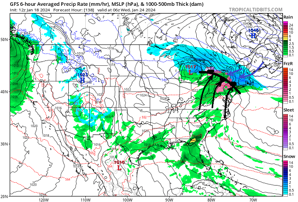
3 minutes ago, radarman said:
Kathy Hochul made the call fwiw
Like most major decisions, it was made in conjunction with NWS folks and emergency management leaders... It really is not even about the game perse; it's about the safety of having thousands of travelers on the road and no way to get to them... Folks have short memories about how many people died last year in the Buf blizzard. I'd love to see a game in blizzard conditions, but it's the big picture more than the game....
-
7
-
2
-
-
20 minutes ago, 40/70 Benchmark said:
Funny how the compression and velocity doesn't impact the cutters...they phase just fine.
That's what I think of all the time... I don't doubt Tip's velocity / compression issues, but I do wonder why there "appears" to be less of an impact on the Midwest bomb events. Now I may be completely wrong,and I've really studied it, but it's just a general sense I get from watching multiple potent Midwest cutters over the last few years.
-
2
-
-
6 minutes ago, WinterWolf said:
The pope’s warm up lol…the guy can’t forecast his way out of a paper bag. That’s a long ways off..just enjoy the potential of what’s in front of us the next 10 days or so.
What I find a bit distressing and it's happening more and more, is the small number of posters who have no desire to enjoy the meteorological setups right in front of them, but instead look for ways to post negative predictions about what it looks like 10 days to 2-weeks down the road. I'm ok with general pattern comments about the extended range period, but for a small handful of folks it's a constant harang of negative ball-busting vibes...
-
5
-
8
-
-
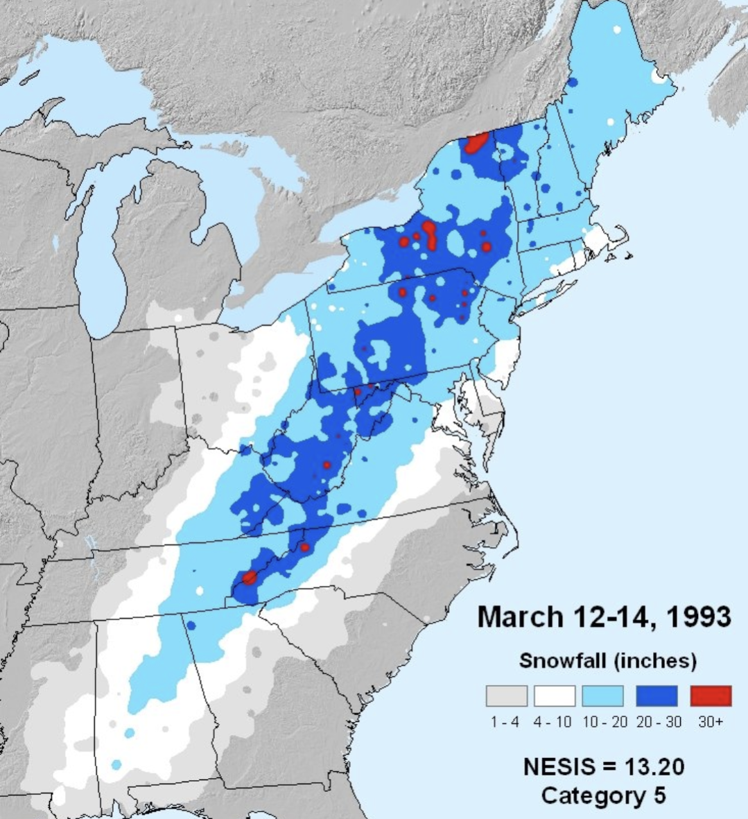
Just now, WeatherX said:
March 1993 Champ
.It was a great storm... Forecasting was excellent... But sleet was a limiting factor for some... Great triple phaser...
-
1
-
-
39 minutes ago, WJX231 said:
March 1993?
Again.. you said 2+ feet!!! The vast majority of the "Northeast" did not get 2+ feet... Pretty obvious on the graphic below...

-
12 minutes ago, WJX231 said:
How often do we get a monster system that drops a widespread 2+ feet for the whole northeast? January 2015 was the last one that I remember. I wish they weren't so rare.
The "whole Northeast" is a non-starter! The nature / structure of Northeast winter storms makes that almost impossible!!! Region-wide 2+ snowfalls are literally impossible to pull off...
-
1
-
-
Road closures across Fairfield County in CT causing delay issues with some districts...

Monitoring the 29th/30th for significant impact coastal redevelopment - confidence only medium for now but is trending favorably.
in New England
Posted
Burlington, Ct