

WxWatcher007
-
Posts
36,088 -
Joined
-
Last visited
Content Type
Profiles
Blogs
Forums
American Weather
Media Demo
Store
Gallery
Everything posted by WxWatcher007
-
I had to relocate once more, but only about a mile. My second option fell though after the owner decided to shut down. It's cloudy and breezy with light rain from the front. I'll be using my Kestrel and basic barometer to document the pressure fall. In a quick drive around we see a gas line at the local station and folks hunkering down by taking furniture inside and getting last minute supplies. Folks are taking this one seriously. Now's the hard part. Waiting. Fiona looks good on satellite, but now we have to see what the final approach and track look like. I think I'm in a good spot still, as a slightly further east track would probably allow for a better wind vector here, and a center pass is obviously a center pass. I am walking distance from the coast.
-

2022 Atlantic Hurricane Season Tracking Thread
WxWatcher007 replied to WxWatcher007's topic in Mid Atlantic
I had to relocate once more, but only about a mile. My second option fell though after the owner decided to shut down. It's cloudy and breezy with light rain from the front. I'll be using my Kestrel and basic barometer to document the pressure fall. In a quick drive around we see a gas line at the local station and folks hunkering down by taking furniture inside and getting last minute supplies. Folks are taking this one seriously. Now's the hard part. Waiting. Fiona looks good on satellite, but now we have to see what the final approach and track look like. I think I'm in a good spot still, as a slightly further east track would probably allow for a better wind vector here, and a center pass is obviously a center pass. I am walking distance from the coast. -
Just shy of major status before a FL landfall in this first forecast. I do think this kind of track would produce an eventual east coast threat.
-
Going to be hauling its way up here today. We’ll see how much intensity it can hold.
-
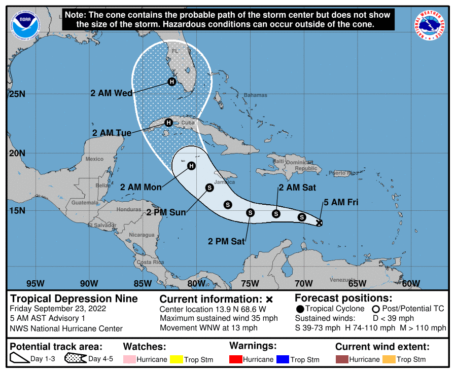
TD 9 coming at 5am per NHC.
-
TD 9 coming at 5am per NHC.
-
We should be able to get a depression or NS today out of 98L, which should help guidance hone in on the forecast.
-
Thanks and I agree. Hopefully the causeway isn't damaged because then I'm here a little longer than I'd like Best of luck out there.
-
Thanks. The thing I worry about most is my current location deciding to shut down and kick me out tomorrow lol.
-
That was the original plan. It was about 35ft ASL so I figured it’d be fine from surge. Hotel decided to shut down and I don’t really blame them given the topography there and lack of guidance on surge potential. When I chase I have multiple options so now I’m on the other side of Cape Breton. Probably not ideal because for higher end wind because I’m on the left side of the track, but what I trade with wind (which probably isn’t much based on what I see so far) I gain with a closer center pass. Hopefully. No matter what, this is undoubtedly going to be a high end event for this region. Potential all timer.
-
Move that mean just south of Tampa and I think we're in business, otherwise we're relying on a lot to get that to curve back toward SNE.
-
For all the research I did, I've yet to come across a storm surge forecast here. That's pretty crazy considering that the eastern shore of Cape Breton is going to take the brunt of the surge. Maybe I'm looking at the wrong place, but the CHC site doesn't have anything and we know that the NHC is big on talking surge.
-
2022 Atlantic Hurricane Season Tracking Thread
WxWatcher007 replied to WxWatcher007's topic in Mid Atlantic
Thanks. For this one I am hoping I can get a nice data set of the pressure fall. -
I wonder where Josh is going to set up. I'm guessing probably not too far from me, but further south. Recon has found Fiona's pressure has fallen to 932mb.
-
2022 Atlantic Hurricane Season Tracking Thread
WxWatcher007 replied to WxWatcher007's topic in Mid Atlantic
Awkward time to jump in lol but... This is WxWatcher007 reporting live from the coastline of Cape Breton Island. Originally, I was planning to be on the east coast of Cape Breton in Louisbourg, but the hotel fell through and I don't blame them from closing up shop. Even with extensive research, we're still missing a critical piece here with clear expectations on surge. As a result, I am on the west coast in Port Hood very close to the center track of Fiona, and under a hurricane watch. The elevation here makes potential surge irrelevant, and depending on the angle of approach, winds could be high end. Folks up here are taking this one seriously. This has the potential to be an all-time event in the region, with guidance consistently forecasting pressure records getting shattered. As is usually the case for the big dogs, @MillvilleWx is providing remote support and can provide an update on the site if I lose signal, which is already a little spotty.- 469 replies
-
- 22
-

-

-
I don’t think it’s a west Gulf pattern either but we don’t even have a LLC yet. There’s going to be plenty of spread at this range. My first speculative guess would be a LF on the FL/AL line, through GA into the coastal Carolinas and barely OTS up here.
-
They will get smoked for sure and are likely right where you want to be to record the lowest pressure, but with the transition ongoing I’m not sure we get a traditional eye even if this held together to have major winds at landfall. I’m expecting the center to expand and push the biggest winds out further. It could be a situation where the eastern shore of Cape Breton and the northern shore of NS see the best winds. You kind of see that across guidance. It’ll be interesting to see if an eyewall stays intact.
-
It’s truly extraordinary to see this kind of stuff so close to an event. Even if it’s 20mb too deep, I think it’d be an all time record for the region.
-
I am hacking the holy hell out of my work calendar for basically the next two weeks. We went from 0 to 100 in the snap of a finger in the basin.
-
The benchmark hurricane.
-
Recon reporting multiple vortices rotating around the eye.
-
2022 Atlantic Hurricane Season Tracking Thread
WxWatcher007 replied to WxWatcher007's topic in Mid Atlantic
Really illustrates how much track uncertainty there is. Definitely worth watching even for the east coast because the latter period pattern could have a trough cutting off and ridge blocking an east escape path if it crossed into the Atlantic. -
2022 Atlantic Hurricane season
WxWatcher007 replied to StormchaserChuck!'s topic in Tropical Headquarters
Gaston! -
Starting to see much higher SFMR readings and FL winds. Eyewall is closed now too. No question that it’s a major now. Off to the races tonight, I think.
