WxWatcher007
-
Posts
35,985 -
Joined
-
Last visited
Content Type
Profiles
Blogs
Forums
American Weather
Media Demo
Store
Gallery
Everything posted by WxWatcher007
-

Feb 28th-March 1st long duration Miller B threat
WxWatcher007 replied to George001's topic in New England
Exactly. We locked. We snow. Let’s get it on. -
Feb 28th-March 1st long duration Miller B threat
WxWatcher007 replied to George001's topic in New England
HREF weenie run at 0z -
Feb 28th-March 1st long duration Miller B threat
WxWatcher007 replied to George001's topic in New England
Well I can tell you where one will be. Right over my valley floor head. -
Feb 28th-March 1st long duration Miller B threat
WxWatcher007 replied to George001's topic in New England
We don’t use the +, but we try to write out exactly what we mean whenever we have the ranges. I went a little deeper with this forecast. Kept the 4-8 inland and took the shore up to 3-6. Expect highest amounts west and the majority of shoreline zone to land between 4-6”. -
Feb 28th-March 1st long duration Miller B threat
WxWatcher007 replied to George001's topic in New England
Yeah, they do pretty well -
Feb 28th-March 1st long duration Miller B threat
WxWatcher007 replied to George001's topic in New England
GFS still solid for CT. A little less valley sucker zone here. -
Given how much the Euro moved to the gfs, I agree that I don’t think we have much room. It’s nice verbatim at D6, but we know how this goes—it’s nowhere near done trending.
-
The D6 clown fwiw

-
In a nod to the gfs, it looks faster now with a Friday start
-
Feb 28th-March 1st long duration Miller B threat
WxWatcher007 replied to George001's topic in New England
You can always count it to pull a TBlizz at crunch time this winter. -
Feb 28th-March 1st long duration Miller B threat
WxWatcher007 replied to George001's topic in New England
That HREF ensemble mean is impressive… -
Feb 28th-March 1st long duration Miller B threat
WxWatcher007 replied to George001's topic in New England
Will probably take up our 2-4” zone since our 2” floor is looking low today (by design). Hopefully everyone ends up near the higher end on this one. -
Feb 28th-March 1st long duration Miller B threat
WxWatcher007 replied to George001's topic in New England
Ramp up, but keep that mix line south of the CT coast. I do think that even if they do mix Tuesday morning the damage is already done in terms of snowfall. This also looks like a more pasty snow than powder? @ORH_wxman -
Feb 28th-March 1st long duration Miller B threat
WxWatcher007 replied to George001's topic in New England
Definitely nice to see the mesos amp up a little. Keep it going through 12z please. -
Feb 28th-March 1st long duration Miller B threat
WxWatcher007 replied to George001's topic in New England
My original bar of 6” is probably too high, but it should be a nice day nonetheless. Despite how I feel about the winter as a whole, I appreciate every opportunity to witness a transformed landscape. -
Feb 28th-March 1st long duration Miller B threat
WxWatcher007 replied to George001's topic in New England
Yeah—no worries here. Just hoping as many as possible are able to have a good wintry day. -
Feb 28th-March 1st long duration Miller B threat
WxWatcher007 replied to George001's topic in New England
I’m good, thanks -
Feb 28th-March 1st long duration Miller B threat
WxWatcher007 replied to George001's topic in New England
It has been showing it a lot but this is the most pronounced. -
Feb 28th-March 1st long duration Miller B threat
WxWatcher007 replied to George001's topic in New England
Our first call map. Guessing we go up for coastal western CT tomorrow but we'll see. Explicitly wrote that the western interior zone is likely to end up the jackpot and the 2-4 zone will see most at 3-4", with potential to go higher in western CT down to the coast. As an aside. I'm so tired. Those who write know what I mean lol. I literally had someone argue over whether it was "warm" recently and it was damn near a +20 day.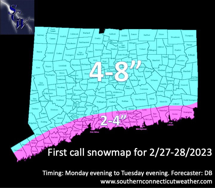
-
Feb 28th-March 1st long duration Miller B threat
WxWatcher007 replied to George001's topic in New England
That’s a chase I’d like to make someday. -
Feb 28th-March 1st long duration Miller B threat
WxWatcher007 replied to George001's topic in New England
Weathermodels isn’t even out yet Edit: now it is. Def good for CT. -
Feb 28th-March 1st long duration Miller B threat
WxWatcher007 replied to George001's topic in New England
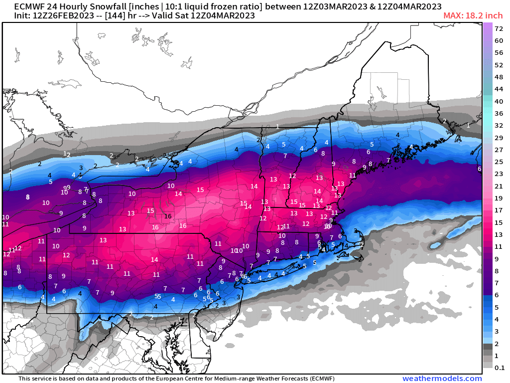
Looking at 2-4 shore and 4-8 interior on our first map. -
New England Met Winter 2022-2023 Banter
WxWatcher007 replied to HoarfrostHubb's topic in New England
I don’t think TBlizz is getting the message. -
.4" on the day. Up to 6.4" on the year.