

WxWatcher007
-
Posts
35,977 -
Joined
-
Last visited
Content Type
Profiles
Blogs
Forums
American Weather
Media Demo
Store
Gallery
Everything posted by WxWatcher007
-

The last hurrah? Putting all the eggs in the Tuesday 3/14 basket
WxWatcher007 replied to Ginx snewx's topic in New England
-
The last hurrah? Putting all the eggs in the Tuesday 3/14 basket
WxWatcher007 replied to Ginx snewx's topic in New England
Temps do bring a slight bit of concern if the low isn’t as advertised, but this certainly looks high end inland even in the absence of a good antecedent airmass. -
The last hurrah? Putting all the eggs in the Tuesday 3/14 basket
WxWatcher007 replied to Ginx snewx's topic in New England
-
The last hurrah? Putting all the eggs in the Tuesday 3/14 basket
WxWatcher007 replied to Ginx snewx's topic in New England
Me too. Just bring nuclear winter over the entire megalopolis -
The last hurrah? Putting all the eggs in the Tuesday 3/14 basket
WxWatcher007 replied to Ginx snewx's topic in New England
That would be good down there. Damn good. Canadian obliterates interior. Let’s keep the euro and Ukie in the flock. -
The last hurrah? Putting all the eggs in the Tuesday 3/14 basket
WxWatcher007 replied to Ginx snewx's topic in New England
-
The last hurrah? Putting all the eggs in the Tuesday 3/14 basket
WxWatcher007 replied to Ginx snewx's topic in New England
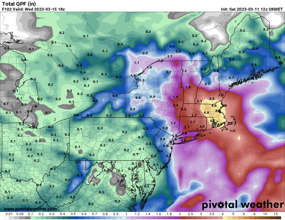
Obviously it’s still fluid and small changes will make a big difference yada yada, but with big qpf, a rapidly intensifying low, and what’s effectively a stall at our latitude—all forecasted to begin taking shape in approximately 48 hours—there is absolutely no excuse for this not to be a widespread 12+ big dog snow for interior SNE. No, 1888 or 2013 aren’t walking through the door, and given the mediocre antecedent airmass I’m dubious of widespread 18+, but if this somehow turned into a widespread 4-8, 6-10, 8-12 type deal then it is an abject failure and unequivocally the crown jewel of one of the worst winters in recorded history relative to its potential. No excuses away from the coast if this doesn’t cut like 12z envisioned yesterday. None. -
The last hurrah? Putting all the eggs in the Tuesday 3/14 basket
WxWatcher007 replied to Ginx snewx's topic in New England
Just keep the shadowing/slotting to a minimum here, please. -
March 10-11 light snow threat for SW New England.
WxWatcher007 replied to Sey-Mour Snow's topic in New England
Until Tuesday, we hope. -
The last hurrah? Putting all the eggs in the Tuesday 3/14 basket
WxWatcher007 replied to Ginx snewx's topic in New England
I have no choice but to hedge a little more conservative imby. A slight shift with more easterly action and I slot badly. Not saying I expect that, but I know my climo lol. Fantastic trend overnight though. You never know for certain how things will go, but I was with you yesterday when 12z wanted to plow west. -
March 10-11 light snow threat for SW New England.
WxWatcher007 replied to Sey-Mour Snow's topic in New England
Couldn’t even clear a coating. -
The last hurrah? Putting all the eggs in the Tuesday 3/14 basket
WxWatcher007 replied to Ginx snewx's topic in New England
We pray. -
March 10-11 light snow threat for SW New England.
WxWatcher007 replied to Sey-Mour Snow's topic in New England
0.0 -
The last hurrah? Putting all the eggs in the Tuesday 3/14 basket
WxWatcher007 replied to Ginx snewx's topic in New England
Would love to see the euro be in the ballpark -
The last hurrah? Putting all the eggs in the Tuesday 3/14 basket
WxWatcher007 replied to Ginx snewx's topic in New England
If anywhere is going to get slotted, we already know it’s me. I’m just glad to see one of the varsity models stay away from ripping this over Bridgeport. -
The last hurrah? Putting all the eggs in the Tuesday 3/14 basket
WxWatcher007 replied to Ginx snewx's topic in New England
Putting it in my file of fantasy gfs runs. Got plenty of mega canes that never materialized in there. -
The last hurrah? Putting all the eggs in the Tuesday 3/14 basket
WxWatcher007 replied to Ginx snewx's topic in New England
AEMATT shook at 12z, WOR crew shook at 00z. Tells you everything you need to know about how uncertain this outcome still is. Steel those backbones, friends. We’re going down to the wire with this one. -
The last hurrah? Putting all the eggs in the Tuesday 3/14 basket
WxWatcher007 replied to Ginx snewx's topic in New England
Better to see it east vs west imo at this stage. We’re obviously in different spots but I’d risk subsidence all day vs that rain line. -
The last hurrah? Putting all the eggs in the Tuesday 3/14 basket
WxWatcher007 replied to Ginx snewx's topic in New England
It’s a beaut. Interior CT crushed on that gfs run. -
March 10-11 light snow threat for SW New England.
WxWatcher007 replied to Sey-Mour Snow's topic in New England
40.6 here lol. Expected. -
The last hurrah? Putting all the eggs in the Tuesday 3/14 basket
WxWatcher007 replied to Ginx snewx's topic in New England
He’ll be back saying “no changes” when the 00z Euro rips the low through Binghamton. -
The last hurrah? Putting all the eggs in the Tuesday 3/14 basket
WxWatcher007 replied to Ginx snewx's topic in New England
And unlike other wx phenomena that I am awed by, snow can totally transform a landscape for the “good”. There is nothing like it. -
I’m not sure I’ve seen a winter in my lifetime with as much wasted potential as this one.
-
The last hurrah? Putting all the eggs in the Tuesday 3/14 basket
WxWatcher007 replied to Ginx snewx's topic in New England
Who cares about food if you’re getting crushed? -
The last hurrah? Putting all the eggs in the Tuesday 3/14 basket
WxWatcher007 replied to Ginx snewx's topic in New England
We’re unquestionably approaching the crescendo of model cinema for the winter. It’s honestly exciting.


