WxWatcher007
-
Posts
35,873 -
Joined
-
Last visited
Content Type
Profiles
Blogs
Forums
American Weather
Media Demo
Store
Gallery
Everything posted by WxWatcher007
-
Gotta imagine some troughing would get that one, but here we are on the cusp of something with Lee.
-
That’s going to be hard to top any year. Would probably need a further west track and more ET transition to maintain some semblance of a core? Cape would be in for a lashing though.
-
Like I said. Team Meh & Team Hit.
-
It’s going to stay bottled up because a major cane is not coming.
-
2mb drop in last pass. 950mb now.
-
It looks like in addition to in storm observations a recon mission sampled the broader steering/shear environment. That may help in understanding when the turn north happens and at what speed. Lee continues to improve on IR with an expanded wind field per recon.
-
Probably mesovorticies
-
Sometimes you can’t help but laugh at what the models produce
-
Latest sonde in the N eyewall has this with 108kt winds. Might be close to being back at category four intensity.
-
That popped into my mind too. Far more expansive system here with ET transition possibly occurring.
-
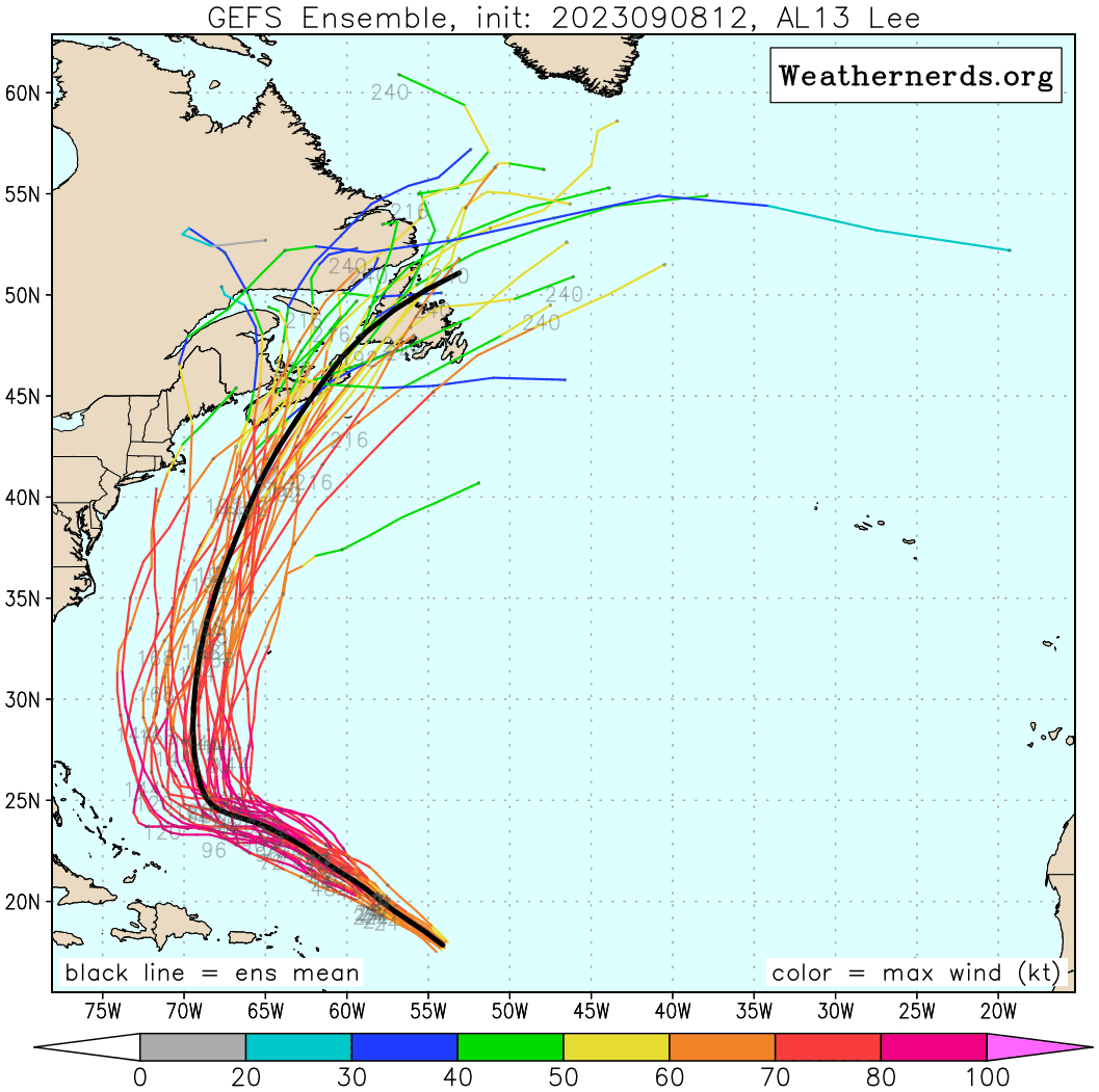
Looking at the last four GEFS runs, the spread has narrowed quite a bit too with the bifurcation now.
-
Looks like there are still those two faster/east and slower/west camps.
-
Good luck, teams.
-
Not doing another long post right now but looking at the general trend in the steering pattern across guidance I update my odds to the following: —50% LF risk Atlantic Canada with the bulk of that risk in Nova Scotia. It’s becoming increasingly likely that the second trough pulls this on an extended northward heading. —30% New England (10% SNE/20% ENE) which is slightly more aggressive than the ensembles. —20% OTS because respect still needs to be given to eastward shifts or a sharper turn caused by the first trough. Either way, it’s looking increasingly likely a close call occurs even in this scenario for Atlantic Canada. If the general trend west/more impactful continues through the 12z suite tomorrow, then I believe this becomes something more legitimate.
-
It just looks “well-timed” to me verbatim on the run. I don’t see how that’s outside the realm of non-long shot possibility. Kinda funny to see the usual tropical fault line establishing itself. For Team Meh, this run isn’t a one off. There’s a three day general trend toward a closer approach across guidance and ensembles. Ensembles still lead by far, which are further east, but the ops become more interesting the closer in time we get. For Team Hit cheering me on now…this is still ~6/7 days out—an eternity in tropical tracking. A trend today can easily shift back tomorrow. And the ensembles still lead. Updating my odds, I think it’s a 50% LF risk for Atlantic Canada/30% New England (10% SNE/20% ENE)/20% OTS.
-
Euro has bounced around hundreds of miles between 00z yesterday, 12z yesterday, 00z this morning, and 12z this afternoon. I’d guess the EPS ticks a little west, but the op runs are zero confidence right now.
-
The New England delegation has a strong weenie presence, but remember, the Euro nailed Sandy.
-
Fixed. It’s always always bad
-
Yeah that was the best I could do. Following the mean line though you can see it go from Cape Breton Island to the SW tip of NS, or about 300 miles. Could easily tick back east, but that hasn’t been the trend lately.
-
Let’s see if this 3 day gif works…12z GEFS the last three days.

-
Sure, but the three day trend generally has been quite a bit west. Agree with @CoastalWx—need to see the Euro/EPS not all over the place before feeling like this is more a NE threat than Nova Scotia.
-
Product: Air Force Vortex Message (URNT12 KNHC)Transmitted: 10th day of the month at 17:48ZAgency: United States Air Force Aircraft: Lockheed WC-130J Hercules with reg. number AF97-5306 Storm Name: LeeStorm Number & Year: 13 in 2023 (flight in the North Atlantic basin)Mission Number: 12Observation Number: 03 ( See all messages of this type for this mission. )A. Time of Center Fix: 10th day of the month at 17:29:30ZB. Center Fix Coordinates: 21.95N 61.35WB. Center Fix Location: 392 statute miles (631 km) to the NE (51°) from San Juan, Puerto Rico (U.S.).C. Minimum Height at Standard Level: 2,728m (8,950ft) at 700mbD. Minimum Sea Level Pressure: 956mb (28.23 inHg)E. Dropsonde Surface Wind at Center: From 310° at 4kts (From the NW at 5mph)F. Eye Character: ClosedG. Eye Shape & Diameter: Circular with a diameter of 30 nautical miles (35 statute miles)H. Estimated (by SFMR or visually) Maximum Surface Wind Inbound: 94kts (108.2mph)I. Location & Time of the Estimated Maximum Surface Wind Inbound: 15 nautical miles (17 statute miles) to the SW (226°) of center fix at 17:25:00ZJ. Maximum Flight Level Wind Inbound: From 312° at 80kts (From the NW at 92.1mph)K. Location & Time of the Maximum Flight Level Wind Inbound: 24 nautical miles (28 statute miles) to the SW (226°) of center fix at 17:22:30ZL. Estimated (by SFMR or visually) Maximum Surface Wind Outbound: 99kts (113.9mph)M. Location & Time of the Estimated Maximum Surface Wind Outbound: 18 nautical miles (21 statute miles) to the NE (47°) of center fix at 17:34:30ZN. Maximum Flight Level Wind Outbound: From 143° at 112kts (From the SE at 128.9mph)O. Location & Time of the Maximum Flight Level Wind Outbound: 19 nautical miles (22 statute miles) to the NE (47°) of center fix at 17:35:00ZP. Maximum Flight Level Temp & Pressure Altitude Outside Eye: 12°C (54°F) at a pressure alt. of 3,049m (10,003ft)Q. Maximum Flight Level Temp & Pressure Altitude Inside Eye: 18°C (64°F) at a pressure alt. of 3,047m (9,997ft)R. Dewpoint Temp (collected at same location as temp inside eye): 12°C (54°F)R. Sea Surface Temp (collected at same location as temp inside eye): Not AvailableS. Fix Determined By: Penetration, Radar, Wind and PressureS. Fix Levels (surface & flight level centers within 5nm of each other): Surface and 700mbT. Navigational Fix Accuracy: 0.02 nautical milesT. Meteorological Accuracy: 2 nautical milesRemarks Section: Maximum Flight Level Wind: 112kts (~ 128.9mph) which was observed 19 nautical miles (22 statute miles) to the NE (47°) from the flight level center at 17:35:00Z Maximum Flight Level Temp: 17°C (63°F) which was observed 7 nautical miles to the SW (227°) from the flight level center
-

Wake Me Up When September Ends..Obs/Diso
WxWatcher007 replied to 40/70 Benchmark's topic in New England
1.67 and counting in last 65 minutes