

Kaner587
-
Posts
2,665 -
Joined
-
Last visited
Content Type
Profiles
Blogs
Forums
American Weather
Media Demo
Store
Gallery
Everything posted by Kaner587
-
 I don’t think the freezing line budges much until the precip ends. The cold air seems to be hanging tough north of the LIE in particular. a very nice coating here (laurel hollow). 28 degrees. Moderate snow/graupel mix
 -
Refresher snow & obs between ~midnight and Noon Sat Feb 17 2024
Kaner587 replied to wdrag's topic in New York City Metro
@uofmiamihowd you make out? Assume 2 or less. I’m up at windham for the wknd we got about 1 here still snowing lightly -
2/13 Significant/Major Winter Storm Discussion & Observations
Kaner587 replied to Northof78's topic in New York City Metro
It ranges from 150-300 feet generally along either side of northern blvd. Where I am in laurel hollow elevation ranges 190-220. The peak elevation is actually in the west hills area with a max elevation of just under 400 feet -
2/13 Significant/Major Winter Storm Discussion & Observations
Kaner587 replied to Northof78's topic in New York City Metro
Woke up at 3am and already had a coating. Knew we were in for 6+ after that. Seriously doubted it when I went to bed -
2/13 Significant/Major Winter Storm Discussion & Observations
Kaner587 replied to Northof78's topic in New York City Metro
The biggest issue I noticed was when rates slipped below 1.5/hr then compaction starting eating away at totals. In the period from 8am-10am and then again 1115-1pm totals rapidly increased but between 6-8am and 10-11;15 despite decent rates it barely kept up with compaction -
2/13 Significant/Major Winter Storm Discussion & Observations
Kaner587 replied to Northof78's topic in New York City Metro
-
2/13 Significant/Major Winter Storm Discussion & Observations
Kaner587 replied to Northof78's topic in New York City Metro
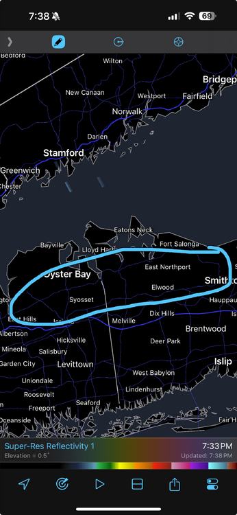
There’s a 8. 1 in glen cove 8.7 in locust valley 8.25 in dix hills further SE towards Jericho tpke, a 7.5 in north syosset 7.8 in muttontown 8 in commack and 7 in smith town. Paints a very clear picture that from about central Nassau between Jericho tpke and north of northern blvd there was likely a local max of 7-9 inches -
2/13 Significant/Major Winter Storm Discussion & Observations
Kaner587 replied to Northof78's topic in New York City Metro
East hills Glen cove, locust valley and laurel hollow, the area along northern blvd central Nassau on east did very well. At about 5pm I was out sledding at a friends (we’re both in laurel hollow off 25a) and there was still easily 7in on grass after compaction so 8in+ for that region makes sense -
2/13 Significant/Major Winter Storm Discussion & Observations
Kaner587 replied to Northof78's topic in New York City Metro
@uofmiamileft for work right as final band was coming through and I was around 7 or just over so imagine 7.5-8 -
2/13 Significant/Major Winter Storm Discussion & Observations
Kaner587 replied to Northof78's topic in New York City Metro
Back edge means business -
2/13 Significant/Major Winter Storm Discussion & Observations
Kaner587 replied to Northof78's topic in New York City Metro
Nice! Down to mod snow now maybe we can pick back up a bit in the next 30 mins as bands swing through -
2/13 Significant/Major Winter Storm Discussion & Observations
Kaner587 replied to Northof78's topic in New York City Metro
I got 4.25 about 20 mins ago. Been banging at 1.5-2in/h since 730 -
2/13 Significant/Major Winter Storm Discussion & Observations
Kaner587 replied to Northof78's topic in New York City Metro
Nice the separation of 1.5 miles does not seem to be making a huge diff lol hope all is well -
2/13 Significant/Major Winter Storm Discussion & Observations
Kaner587 replied to Northof78's topic in New York City Metro
Not saying it’s right and who knows maybe ratios will be 6:1 but euro and hrrr have 0.75-0.9 falling in 3 hours over the metro -
2/13 Significant/Major Winter Storm Discussion & Observations
Kaner587 replied to Northof78's topic in New York City Metro
@uofmiami 1.75 on the grass here you have any measurements yet -
2/13 Significant/Major Winter Storm Discussion & Observations
Kaner587 replied to Northof78's topic in New York City Metro
You and I not too far off! -
OBS and nowcast Thursday morning 2/18 - 11PM Friday 2/19/21
Kaner587 replied to wdrag's topic in New York City Metro
High water content too of the pack. In shaded areas pre storm I had 6-7in with a hard layer over an inch thick of ice. With the 7 in yesterday and today with 0.25 of ice in between -I agree about 10-12in especially in shaded areas and with especially high water content for that depth -
OBS and nowcast Thursday morning 2/18 - 11PM Friday 2/19/21
Kaner587 replied to wdrag's topic in New York City Metro
Some of the Best snow today for nyc metro fell along the north shore of LI eastern Nassau out into Suffolk -
OBS and nowcast Thursday morning 2/18 - 11PM Friday 2/19/21
Kaner587 replied to wdrag's topic in New York City Metro
2.25in today and 6.75in total in Laurel hollow NE Nassau -
Solar min finally exerting its effect???? There’s always at least one blocky winter surrounding it. Obviously that’s not the only or main driver (qpo ENSO pdo etc) but interesting nonetheless).
-
Obs and nowcast Super Bowl Sunday 4A-6P Feb 7, 2021
Kaner587 replied to wdrag's topic in New York City Metro
8.5in in laurel hollow. Great event was only expecting 3-4 -
December 16-17, 2020 Storm Observations and Nowcast
Kaner587 replied to wdrag's topic in New York City Metro
Kphl 6.6 knyc 10.5- 1,011 replies
-
- 2
-

-
- heavy snow
- sleet
- (and 4 more)
-
December 16-17, 2020 Storm Observations and Nowcast
Kaner587 replied to wdrag's topic in New York City Metro
North of you in laurel hollow we have 8in+ (couldn’t get a great measurement) -
I haven’t posted in here in a very long time. Nice to be back! loving that we have a real threat to track. The trends the last 36-48h have been pretty incredible. More confluence better PNA more consolidated s/w.
- 3,762 replies
-
- 2
-
-
- heavy snow
- heavy rain
- (and 3 more)


