

FallsLake
-
Posts
6,317 -
Joined
-
Last visited
Content Type
Profiles
Blogs
Forums
American Weather
Media Demo
Store
Gallery
Everything posted by FallsLake
-
Does not support the wintery look of the GFS (at least out to day 10): http://wx.graphics/models/ecmwf/ecmwf_usa.php
-
Latest from RAH for tonight: PoP has also been increased into the chance range for rain/snow showers for tonight, given the expected development of a band of scattered to numerous showers along the Arctic front. Measurable liquid equivalent amounts are expected to remain very light, however, with a few hundredths of an inch or less anticipated. Any resultant snow amounts would be even lighter - perhaps a scattered coating on car tops, etc, across the nrn Piedmont, where precipitation intensity and likelihood of snow will be greatest, for an hour in any given location. Winds will also increase with the frontal passage, with following CAA/mixing and surface gusts between 25-30 mph. *****I'll take a light dusting..
-
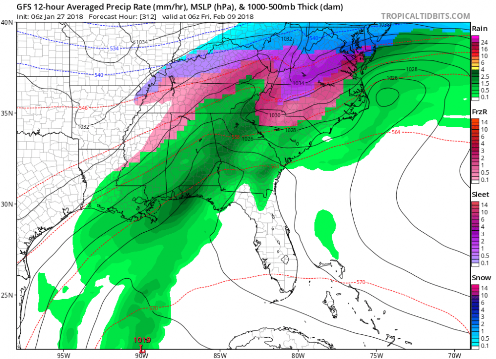
A little more than that for the storm total. ****below includes ice, but still would be a significant storm as modeled.
-
I definitely know better, but man the cold air mass coming down at hour 384 is cold.
-
The PNA, AO, and EPO are all going to be good. The NAO is of course our problem child. http://www.cpc.ncep.noaa.gov/products/precip/CWlink/daily_ao_index/teleconnections.shtml
-
Yeah, the GFS was a good run. Almost looks like the last setup (at this time range) with the low forming pretty far out in the Atlantic. The question would be is how much precip could work westward. And does the low eventually form closer to the coast.
-
It looked ok to me. Keeps cold air in NA and keep the potential of storms. Also has a fantasy major ice storm for many CAD areas starting at day 12. Then at day 16 still shows cold air to our NW with chances of movement SE. Fantasy ice storm:
-
Part of RAH's afternoon discussion for this coming Monday night: The mid level trof will amplify behind the system as a strong short wave digs southeast into the Ohio Valley Monday night. The trof will be nudged east, reinforcing the cool air advection as heights fall and we will probably see some snow showers/flurries, especially in the northern tier counties overnight as the trof axis pivots across the area. Would not be surprised if we need to ramp up the PoPs and maybe need to add a few tenths of snow accumulation as the details emerge. Temperatures will fall below freezing towards midnight across the north, with lows Tuesday morning ranging from 25 to 30 area-wide as the cool air settles in for midweek.
-
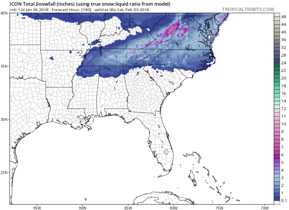
Here's the snow map for hour 180:
-
6z GFS still shows it along with the day 8 event. Problem with both, the first is a clipper and the second is cold chasing/overtaking rain. Both can work(like last storm), but usually don't. Something to keep an eye on but I wouldn't get excited until we get a lot closer.
-
Toss all model solutions past day 10. Especially if there is a potential pattern change incoming.
-
There's different sites and sources. I look at (GFS based): http://www.cpc.ncep.noaa.gov/products/precip/CWlink/daily_ao_index/teleconnections.shtml
-
The LR indices look good today. The PNA, AO, and the EPO all look favorable. The NAO now looks to stay positive; but no worries, it's been this way for the last three years. In the future I may just leave it off the discussion.
-
Just glancing at the RDU daily climate reports, we'll still end up below normal for the month. We had some days with very low departures to normal. http://w2.weather.gov/climate/index.php?wfo=rah
-
I hope nothing serious has happened. Otherwise I hope he comes back. He's one of the big knowledgeable posters. When everybody contributes, incredible amounts of weather information flows from this site. He's part of that...
-
I agree. He hasn't responded in over two weeks. Was there any issues on this site; like arguments with other posters? If not, it would be nice to check (if possible).
-
That's rain changing to snow. So cold air overtaking the system with perfect timing; which we know is usually an issue (...and is 11 days out). The most important thing about the 12 GFS is the pattern that it show for the LR. We have to try not to look at the fantasy storms that should start popping more in the coming days. **but we will look...
-
Lol...You beat me to it Fraz..
-
LOL, I really like how the 12z GFS is depicting the change to a colder patter after day 10........and I like the fantasy storms as well
-
1980 --- I was just a kid living down in Goldsboro, but I remember four foot drifts from what was truly a blizzard. Lots of snow, high winds, and very cold temps (falling into the single digits at the height of the storm). The NE part of the state did end up with more than 2 feet:
-
Indices looking even better today: PNA - Looks to go positive in the LR (good) AO - Looks to go strongly negative (great) NAO - Looks to go negative, by average, in the LR (incredible, because we never see this anymore) http://www.cpc.ncep.noaa.gov/products/precip/CWlink/daily_ao_index/teleconnections.shtml EPO - Looks to go negative in the LR (good) ftp://ftp.cdc.noaa.gov/Public/gbates/reforecast2/teleconn/4indices.png The above would support CRs pizza map....
-
I'll take a sleet storm. Just have to get enough to make it relevant. I've said this 10 times in the past, but my favorite storm of all time was the 1996 January storm. Got 6" of mostly sleet which was amazing. Stayed cold afterwards and a week later had a huge freezing rain event. Even the January storm of last year was great (to me). That was nearly 5" of sleet and snow.
-
Here's the link to the free videos: https://www.weatherbell.com/#premium
-
Indies today looking better for the LR: NAO - Actually has about 40% of the members going negative, but the average is still positive (not good, but there's hope) AO - Has about 80% of the members going negative; with many strongly negative (good) PNA - Has almost all the members going neutral or slightly positive (ok) EPO - Looks to go slightly negative (ok/good)
-
That was a good post. The indices from yesterday look like they want to improve in the LR. So I feel good with how things are progressing. We just need one more decent winter storm; then bring on spring.


