

FallsLake
-
Posts
6,317 -
Joined
-
Last visited
Content Type
Profiles
Blogs
Forums
American Weather
Media Demo
Store
Gallery
Everything posted by FallsLake
-
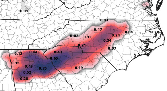
This just isn't the ideal setup (as currently modeled). The best model (..for me) is the CMC. It has RDU under freezing rain for a good period; which would meet winter storm criteria. But surface temps even on the CMC hover at or even a little above freezing for the event. So areas (outside mountains) that get snow will see temps at the 33/34 level and the ice folks will see 31/32. Both not ideal for accumulations. Looks good, but...
-
Last nights discussion from RAH: Saturday Night through Tuesday: A complex weather pattern begins to take shape late Saturday, as the controlling area of high pressure is forced off the Mid Atlantic Coastline by a digging upper-level trough. Closer to the surface, a series of short waves will round the base of the trough helping to initiate the initial stages of cyclogenesis across the Gulf Coast, progressing a strengthening winter storm north and east to off of the North Carolina Coastline by early Monday morning. Both the GFS/ECMWF continue to come into better agreement with the overall timing, but still differ in overall impacts across our region. In general, expect precipitation to push north and east into the area mainly after sunrise on Sunday and continue for roughly 24 hours into early Monday morning. Some concern that the precipitation may start as a wintry mix at the onset, but with arrival time being pushed back by a few hours with the latest model trends, this threat seems to be becoming less likely. Have kept the possibility of a mix of rain/snow mainly west of US-1 before 10am on Sunday, before transitioning the precipitation type back to all rain through Sunday Night. Another transition back to light snowfall will be possible early Monday morning as the low lifts north and east, with high pressure soon to fill in Monday evening into Tuesday. Plenty of uncertainty with this portion of the forecast, so be sure to check back frequently as we monitor the changing guidance and weather trends.
-
Even the CMC has surface temps above freezing. At best there'll be sloppy 2" amounts. We need the initial cold air (single digit dew points) on Saturday to hang in longer. It could, we need some type of in-situ CAD to help us out.
-
Yeah with the marginal cold and the low position, the higher elevations can make this work. Kind of like spring storms...
-
6z GFS is close with a couple of events during the next 7 days. Verbatim, it does show some wintery precip for the mountains and foothills, but nothing father east. It's close enough that we need to keep an eye on (hopefully good) trends the next couple of days. As of right now it's looking more favorable for the MA folks (...and again maybe our mountains).
-
It really matters on what your discussing. If its pattern related, you could go all the way out to day 16. For storms you can show something at day 10 but really discuss it in the content that a storm is possible. Don't focus on the fact that the cut off line runs through Wake County. At day 7 and under, we can start posting more about the possible storm details. Then at day 5/4 and under you can say Boom! **at least that's what I do...
-
Good discussion from RAH: Friday night through Monday: Surface high pressure will build into and through the area Friday night, shifting offshore by late Saturday and Saturday night. As a result, Friday night through Saturday is expected to be dry with below normal temperatures. Aloft, NW flow Friday night will shift to westerly on Saturday then more southwesterly Saturday night as an upper level trough sets up over the Midwest. A surface low develops over the Gulf Coast Sunday morning as the Canadian high pressure drives south through the Midwest. The low is expected to shift eastward through the FL panhandle, then northeast along the Southeast US coast Sunday and Sunday night. Over Central NC, a lingering ridge may inhibit some of the warm advection at the surface early on and with the current forecast track of the low, Central NC will be on the northern edge as it passes to the south and east. There is a lot of uncertainty, as the temperature, timing of the system and when/if the associated cold front moves into/through the area, will play a huge role in if, where and how much snow Central NC receives. Will continue to mention the chance for rain or snow Saturday night and Sunday night, while the daytime temperatures will likely be warm enough for a transition to all rain. Will continue to keep a close eye on this system in the coming days, but for right now its too early to speculate about impacts with this system given the high degree of uncertainty.
-
Looking at the first 10 days on the GFS, and it's actually a good pattern to see a winter storm. We just need to get the right storm setup.
-
^^Yeah, the GFS was not good verbatim, but all the players are still on the field. We do have initial cold, a storm traversing to the SE, and in coming cold (..but too late as currently modeled). So, we still need to keep an eye on this potential.
-
6z GFS continues to show the threat for next Monday. RAH keeping an eye on this: Saturday through Monday: With high pressure building in, expect quieter and cooler conditions to stick around on Saturday ahead of a much more complex weather pattern set to begin as early as Sunday morning. While model guidance varies widely at this point, the overall pattern seems to indicate that a period of wintry weather will be possible Sunday into Monday. Based on current 00z model guidance, it seems that the best period for frozen precipitation may actually be a bit delayed, arriving with a rather robust burst of cold air on Monday, however, with a cold airmass in place and timing of the initial moisture surge expected during the overnight hours Sunday, a mix of light rain/snow isn`t out of the question as early as Sunday morning. Still plenty of changes likely to occur with this this challenging setup, so stay tuned over the next several days as the forecast begins to clear up a bit.
-
Does not support the wintery look of the GFS (at least out to day 10): http://wx.graphics/models/ecmwf/ecmwf_usa.php
-
Latest from RAH for tonight: PoP has also been increased into the chance range for rain/snow showers for tonight, given the expected development of a band of scattered to numerous showers along the Arctic front. Measurable liquid equivalent amounts are expected to remain very light, however, with a few hundredths of an inch or less anticipated. Any resultant snow amounts would be even lighter - perhaps a scattered coating on car tops, etc, across the nrn Piedmont, where precipitation intensity and likelihood of snow will be greatest, for an hour in any given location. Winds will also increase with the frontal passage, with following CAA/mixing and surface gusts between 25-30 mph. *****I'll take a light dusting..
-
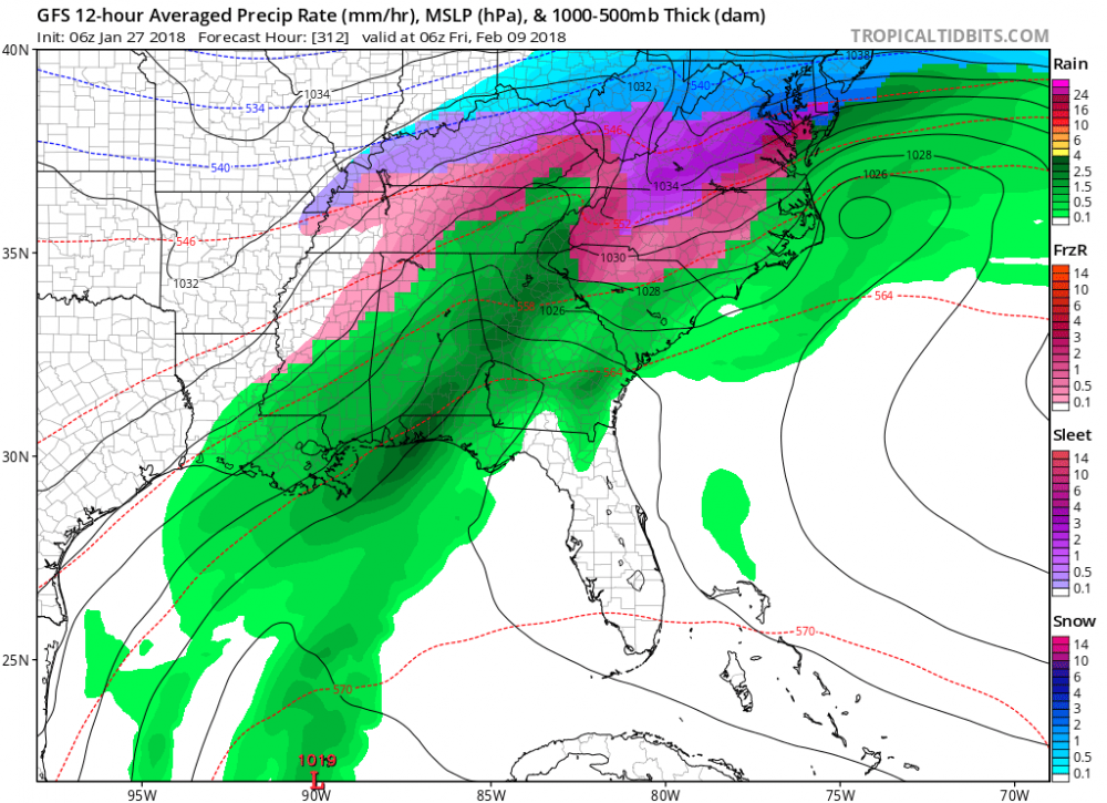
A little more than that for the storm total. ****below includes ice, but still would be a significant storm as modeled.
-
I definitely know better, but man the cold air mass coming down at hour 384 is cold.
-
The PNA, AO, and EPO are all going to be good. The NAO is of course our problem child. http://www.cpc.ncep.noaa.gov/products/precip/CWlink/daily_ao_index/teleconnections.shtml
-
Yeah, the GFS was a good run. Almost looks like the last setup (at this time range) with the low forming pretty far out in the Atlantic. The question would be is how much precip could work westward. And does the low eventually form closer to the coast.
-
It looked ok to me. Keeps cold air in NA and keep the potential of storms. Also has a fantasy major ice storm for many CAD areas starting at day 12. Then at day 16 still shows cold air to our NW with chances of movement SE. Fantasy ice storm:
-
Part of RAH's afternoon discussion for this coming Monday night: The mid level trof will amplify behind the system as a strong short wave digs southeast into the Ohio Valley Monday night. The trof will be nudged east, reinforcing the cool air advection as heights fall and we will probably see some snow showers/flurries, especially in the northern tier counties overnight as the trof axis pivots across the area. Would not be surprised if we need to ramp up the PoPs and maybe need to add a few tenths of snow accumulation as the details emerge. Temperatures will fall below freezing towards midnight across the north, with lows Tuesday morning ranging from 25 to 30 area-wide as the cool air settles in for midweek.
-
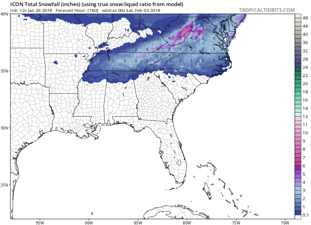
Here's the snow map for hour 180:
-
6z GFS still shows it along with the day 8 event. Problem with both, the first is a clipper and the second is cold chasing/overtaking rain. Both can work(like last storm), but usually don't. Something to keep an eye on but I wouldn't get excited until we get a lot closer.
-
Toss all model solutions past day 10. Especially if there is a potential pattern change incoming.
-
There's different sites and sources. I look at (GFS based): http://www.cpc.ncep.noaa.gov/products/precip/CWlink/daily_ao_index/teleconnections.shtml
-
The LR indices look good today. The PNA, AO, and the EPO all look favorable. The NAO now looks to stay positive; but no worries, it's been this way for the last three years. In the future I may just leave it off the discussion.
-
Just glancing at the RDU daily climate reports, we'll still end up below normal for the month. We had some days with very low departures to normal. http://w2.weather.gov/climate/index.php?wfo=rah
-
I hope nothing serious has happened. Otherwise I hope he comes back. He's one of the big knowledgeable posters. When everybody contributes, incredible amounts of weather information flows from this site. He's part of that...


