FallsLake
-
Posts
6,317 -
Joined
-
Last visited
Content Type
Profiles
Blogs
Forums
American Weather
Media Demo
Store
Gallery
Everything posted by FallsLake
-
I'm sorry to say we'll probably go straight from using heat to AC.
-
12z 3k NAM indicates a freeze potential for northern/interior areas of the SE (..overnight decoupling of winds will be key):
-
This is funny: https://www.cnn.com/videos/weather/2018/04/14/weatherman-rant-michigan-orig-mss.cnn/video/playlists/must-see-viral-videos/
-
Canadian is close to the same look. Crazy spring...
-
-
Just looking at averages (low elevations), during the next couple of weeks most will experience their last freeze until Fall. It seems the first week of April is a prim time. The GFS has a cold look ~ day 13, Canadian for the day 9/10, and the Euro ~ day 10. Hot weather is a couple of months away...
-
Sure haven't. If anybody has any info it would be nice to know he's at least ok.
-
There's definitely a lot of positives on a potential winter storm. But there are also negatives; chiefly the time of year. High elevations can score in late March, but folks "off the mountain" have to get the perfect setup. **I'm tracking this storm but I have no expectations.
-
This will be a case where you want to be as far northeast as possible (it's usually NW). Durham or Wake Forest could get more than Greensboro. Model runs will be interesting today.
-
18z NAM is a little south of the 12z location. Basically gets the snow/rain line to the Triangle. Hopefully it keeps shifting slightly southward.
-
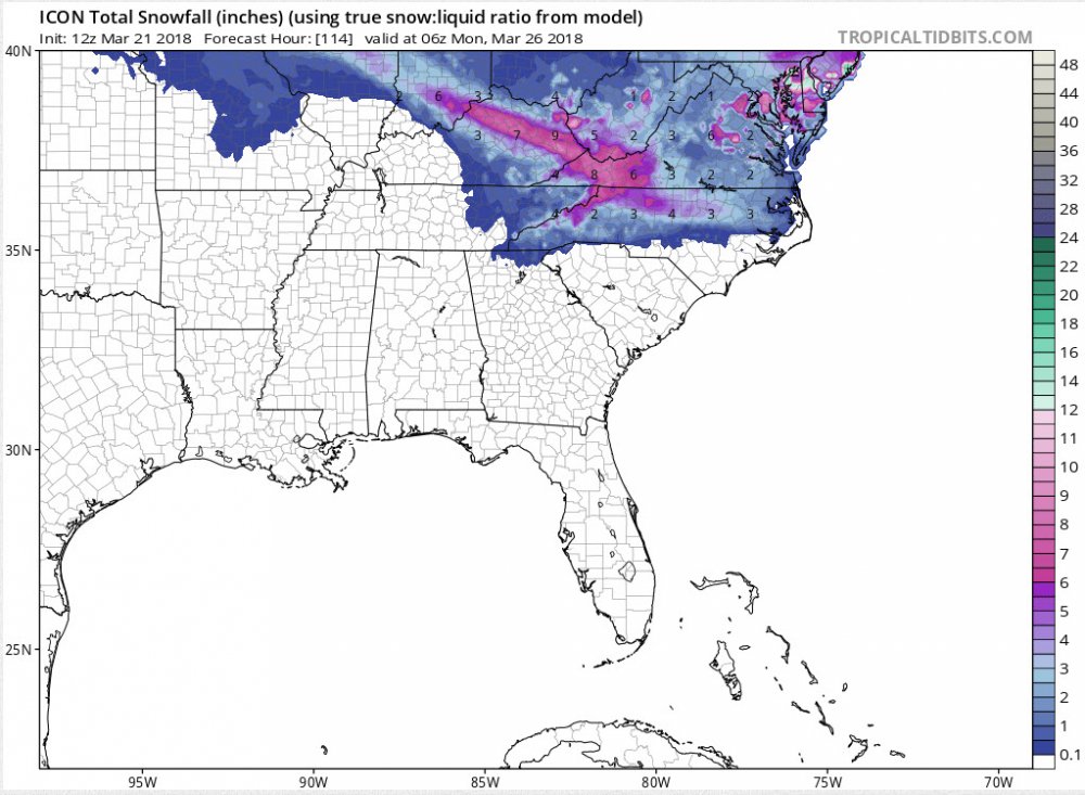
Sure does. The GFS was slightly north with transition line, but it did have slightly colder surface temps (compared from 6z to 12z). Here's the ICON:
-
These are the recorded weather conditions at RDU from yesterday (from that big thunderstorm last night): WEATHER CONDITIONS THE FOLLOWING WEATHER WAS RECORDED YESTERDAY. THUNDERSTORM HEAVY RAIN RAIN LIGHT RAIN HAIL SLEET FOG FOG W/VISIBILITY <= 1/4 MILE Cool storm
-
Snowing here at the office (Capital Blvd / Mini City).
-
Crazy weather we're having. In late February I thought we were heading for a record early bloomage. Now I'm thinking the opposite. A lot of the flowering trees have blooms but all the others nothing.
-
RAH is also mentioning the possibility. They have added snow/rain to the grid forecast as well. Crazy spring....
-
Yeah I'm not liking the trends. If models don't shift back south today (by 12z), I think flurries or snow showers will be best we can manage. But I'm actually ok with that solution. It's spring and I'm ready to start the season. **winter keeps gasping for that last breath of air...
-
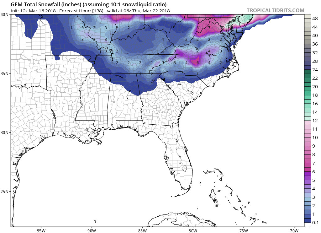
The 12z NAM shifted the goods north. The MA folks are loving the numbers (> foot).
-
From RAH: Hazardous Weather Outlook Hazardous Weather Outlook National Weather Service Raleigh NC 916 AM EDT Sun Mar 18 2018 NCZ007>010-021>026-038>041-191330- Person-Granville-Vance-Warren-Forsyth-Guilford-Alamance-Orange- Durham-Franklin-Davidson-Randolph-Chatham-Wake- 916 AM EDT Sun Mar 18 2018 This Hazardous Weather Outlook is for central North Carolina. .DAY ONE...Today and Tonight. Hazardous weather is not expected at this time. .DAYS TWO THROUGH SEVEN...Monday through Saturday. A low pressure system will result in a chance of rain and snow Tuesday night into Wednesday. While confidence in details remains low, a light accumulation will be possible. .SPOTTER INFORMATION STATEMENT... Spotter activation is not expected at this time. $$
-
Some of the 18Z and 0z the model runs started to trend more north with the potential Wednesday event. They look to have stopped that trend and even shifted back southward with the 6z runs. I like what the NAM is showing, particularly for NC. Some of these models are showing over 4" but we have to keep our expectations down to maybe getting another output like last week; whereas somebody lucky might see 3" but most (in the snowfall areas) will see less than 1".
-
I'm having a hard time believing the possibility. But all the models support a change over to snow with accumulations (...10:1), it's less than 5 days out, and RAH has put snow in my grid forecast. So I agree, let's reel it in...
-
From RAH: Additional mid/upper level energy is expected to dive southeastward and into our area for Tuesday night into Wednesday. Model continue to struggle with how this system will evolve, but there remains the potential for a mix of rain/snow across northern/northeastern portions of the area on Wednesday/Wednesday evening. Dry weather is expected to generally return for late week with the mid upper level trough axis expected to shift to the east. Temps during the medium range are generally expected to remain below normal, with temps well below normal in the heart of the CAD (Piedmont) early this week and again on Wednesday with the threat of wintry precip.
-
All the overnight and early morning model runs still have snow showing(similar to yesterday) for the day 5 period. **I haven't seen the euro except for the crappy Tropical Tidbits maps.
-
12z CMC for day 5/6 (of course the 10:1 ratios thing):

-
I think there's a very good chance of that. The temps never got below freezing after the first few days of February.
-
Maybe we can get both: strong wintery convection...