
Torchageddon
-
Posts
1,571 -
Joined
-
Last visited
Content Type
Profiles
Blogs
Forums
American Weather
Media Demo
Store
Gallery
Everything posted by Torchageddon
-
Rainfall amounts imby ramped up now to 40 mm with heavy rain ongoing. Areas of extreme SON getting impressive radar returns like Ingersoll and Tilsonburg.
-
This is a wicked outlook, the geographical extent of both mod and enh are so large that the chances of this not being a memorable day are rapidly diminishing. Even if there is a failure mode somewhere you can still have all hell break loose in another spot.
-
Just caught the heaviest snowfall rate of the winter here, big fatties for minutes then nil from some LES chunks. Yeah it was more impressive than any rate during the fake blizz near Christmas IMBY. I get the feeling my heaviest rates all seem to be clustered at the end of Feb or in Mar for some reason. Not talking totals just rate of snow. Its -3C/27F.
-
TWN showing me at -14C/7F windchill at -18/-0.5F at 8am. My station showed a low of -11C. Warming up rapidly starting at 8:40 where I was getting 0.7C increases in 5 min intervals. High of 4C this afternoon so I expect to hear a lot of noises!
-
Bottom of the barrel day - overcast, bitterly cold where it was still -7C at 11am with a windchill of -14! My overnight will have a chill of -18 with full snow cover, 11 years ago that same early morning had a severe thunderstorm with hail and double digit positive temps . My appreciation for it was abundant as we know days like today are possible. This is far colder than mid-Feb here and colder than 80% of Jan. I dread winters just like this one when Spring is going to be the dumping ground for the real crap.
-
Was bracing for a crappy day with cold temps and overcast the whole day; instead its 80-90% blue skies and warmer by about a degree . What is most betwixing: hourlies/current still show overcast the rest of the day and temp -5C!!! Keep circling that drain twn
-
23 years ago today it was 24C/75F here, parts of extreme SON had 28C. I have a foot or more of snowcover and a terrible ice layer on driveways now . At least its been blue skies again.
-
 Even more so that Freddy is back and may become the longest lasting tropical cyclone in recorded history; this definitely isn't a board that into the tropics.
 -
I measured in different spots 8-10 cm or 4". Drifting was present of course. It was light-mod snow the heavy stuff didn't get here. This all occurred in 3 hours. I don't have a snowboard
-
The vanishing returns are happening above me as I type this, probably at 8cm. Pressure was 993mb RH at 100%. Windows to the north are covered in droplets.
-
My first snow started 2 hours later than forecast (first time) and I'm in a heavier band of SN although the size of flakes are small. Not close to the amounts shown thus far which is what I expected.
-
It is so brutally cold out despite warming rapidly from overnight low of -8C to 1.8C, loathe it. Its hard for me to feel warm indoors even with the thermostat cranked. Last day of Feb was also the same.
-
Mod snow rates have started here, higher winds than the last event that gave me 10cm of snow. The precip started 2 hours faster than advertised; I can't remember when the cf or system ever was slower than the forecast.
-
I legit laughed harder than I ever have before on here when I saw this, to the point of tears!
-
2023 Short/Medium Range Severe Weather Discussion
Torchageddon replied to Chicago Storm's topic in Lakes/Ohio Valley
Now that is a Feb morning worth its salt. A photogenic one at 8am!? -
Hilariously bad algorithm, the temp is off by 5C (its still -5.5C not -2C like it showed this morning) and nothing on radar anywhere to give me freezing drizzle unless it just generates in place. I see nothing of the sort on current radar. 60% POP? lol.
-
I was wondering why no one here was mentioning this historic warning, I just saw it:
-
Forecast to get 4.5", got 1" of fluff instead lol. Getting some sun breaks but presently snowing good. Highway 402 is getting crushed by a north band similar to that epic LES in Dec 2010.
-
A gradient like that would almost make me want to drive to Toledo
-
Last year I got the BA5 sub-variant in late summer and 5 days in I lost 70% of my taste/smell. I remember well what I was doing when my olfactory nerve cells were being attacked and how fast it set in. Its nothing like I've ever had but the best way to describe that is its like your nasal passages are being inflamed. Not only can you not smell anything but for a day or so in my case there was this "smell" or neuron signal of inside that you couldn't get away from even if you weren't breathing in which was unpleasant. I could still taste certain items but it took over a week to get most of my taste back and over a month+ to get entirely normal again. I never had the fatigue.
-
Since I got back from my trip, its been terrific weather of pure sunny skies til this afternoon when ripples of light snow that melted on contact lasted 15 mins. I couldn't have received a better gift since it was the opposite when I left of endless overcast crap that I thankfully escaped from. Highs of single digits in C since the start of the weekend. Three blue sky mornings in mid-Feb like this is very rare here, I had trouble even spotting a cloud. It got to 5C for my high today, dropped in mid-afternoon. This felt like the first Spring day honestly its not like it got to 16C but something just feels different; the clouds also had some volume to them another rarity for this time of year. Somehow another sunny day tomorrow and 9C, rain and high winds on Weds, 11C, I'm guessing much of my snowpack will be wiped out by that.
-
I'm not sure what I got during the 23-25th storm was even a synoptic snow storm since barely anything fell from the low itself! It was all lake-effect that gave me the 40-50 cm. Equilibrium still hasn't been met. This Jan is the classical & ultimate form of boredom. Profane.
-
I'm impressed by how heavy the rains have been during the last 24 hours. I may reach 30 mm afterall. The returns near Miss and Hamilton are drench-worthy. The squirrels are back out playing and buds are appearing on some bushes. Spring I guess.
-
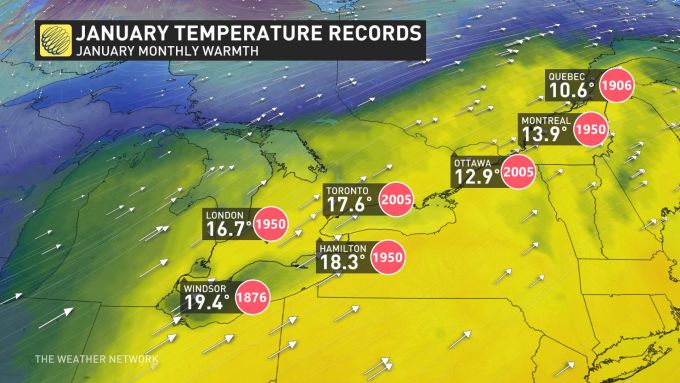
All-Time Jan records map, I didn't know Windsor's records go back to 1870s. That may mean there has never been a 20C+ reading in SON since the beginning of records for the month of Jan.
-
Tues Jan 3 jumped from 8C to 13C in one forecast cycle now with moderate-heavy rain. Sun-ish by next weekend.
