

SouthCoastMA
-
Posts
8,571 -
Joined
-
Last visited
Content Type
Profiles
Blogs
Forums
American Weather
Media Demo
Store
Gallery
Everything posted by SouthCoastMA
-
Nice secondary max out there..gotta be some 4" totals
-
Correction, misread the station 3.04" since midnight 3.39" storm total
-
another downpour moving in..should eclipse 3" soon. max rainfall rate reached 5.88" in/hr on ambient
-
Thanks, we waited long and hard for this moment
-
2.66"
-
About an inch in the last 15 min from a month plus of stein to a flooded yard..
-
.07", but things could get interesting tomorrow. let's get some boomers
-
Actually looks decent for two convective chances tomorrow morning, then later in the afternoon/evening. Would be tough to go 0-3 with one system, but Stein still has his fastball
-
Seems like tomorrow morning is our best shot, but that could easily miss south.
-
Average to just above normal is fine for July and August All set with that HHH (94/78) bs
-
it's been awful here for 3 weeks. need it more than ever
-
Stein is embedded in the DNA of these systems. I'm not trusting any meaningful qpf being modeled here until I see it
-
shut out again, stuck on 0.33" for the month. Really need Monday to pan out
-
Meh, wagons East with the precip. HRRR was more correct
-
Models throw me a bone later with maybe .25". especially the Canadians
-
NE CT attracts the biggest weenies
-
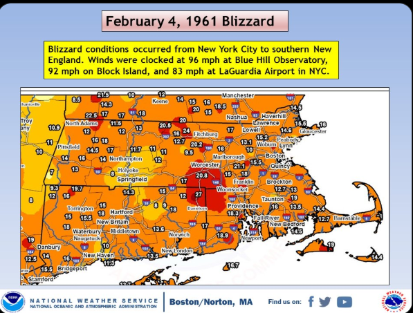
For airports yes. The public not until the late 90s? I'm just saying, with that track I'd expect to see a lot more 20"+ amounts especially in EMATT
-
0.00" sitting in 0.33" for the month
-
That stuff to your west should reach you, unless it fizzles
-
can't wait for my passing shower later that amounts to <0.03"
-
With how measurements are done now, these totals would likely be 1.5x what was reported here: Tblizz would be reporting a 30 burger with that storm track
-
Lawn should be a goner by the weekend. not expecting much Thursday
-
Still pretty warm today. ~79/70 late this mornng
-
Actually looked at the forecast, and my high temps are still above normal this week. I know inland has "higher" expectations with AHATT
-
ill take 70s here. good for a work week


