.png.2082198afdafcedf9ad03f1d6dfb7336.png)
HIPPYVALLEY
-
Posts
32,765 -
Joined
-
Last visited
Content Type
Profiles
Blogs
Forums
American Weather
Media Demo
Store
Gallery
Everything posted by HIPPYVALLEY
-
Yeah got down to 25° here a little while ago while some of the hill towns near me were upper 30’s.
-
Oil will be $120 by Friday. Winning. Looks like we will cool to BN for a bit before real spring takes over.
-
Already down to 37° off of a high of 53°. Radiators are goin’ to radiate.
-
Sky is finally brightening a bit. Up to 42°.
-
Still stuck in the upper 30s in the valley.
-
This 34° drizzle is pretty sweet.
-
I think we’ve had 5 sunny days here out of the past 20.
-
Winter is the shortest month of the year in NYC.
-
Stone Cow? Beautiful area.
-
I’m bitchy and biased but this week, kind of brought Greenfield to an A- winter grade.
-
32° with drizzle. This could go in either direction the next few hours. Snow pack is dense, deep and ripe!
-
This week got me over 60” and my average is 58”. There is a deep snow pack in Greenfield still, even in town. Some of the deepest dense pack I’ve seen in a March.
-
we call that Seasons in Seasons.
-
That’s it, I’ve hit the wall. I’m letting whatever fell last night, freeze on the driveway tonight. It will melt soon enough.
-
Uhg, solid .50” of sleet, 30°. Not even gonna try to clear. It will melt off the driveway eventually.
-
Scalping sleet in Greenfield. Slippery 32°
-
34/33 -RA
-
Interestingly, temperatures are up a degree or two around here since the light rain started. Even up at the elevations. Latent heat release?
-
They are probably going to stick with 1”-3”. I mean, we’ll see at afternoon update.
-
Yeah, 37° and overcast in Greenfield.
-
Yesterday was so much more fun than the blizzard. I went out and did a two hour hike with a friend of mine and it was +SN the entire time.
-
I just want the outcome that catalyzes the most masochistic posts from you. Entertain us with your weather prose.
-
I’m going to say the BOX p/c is incorrect. Greenfield is currently under a WWA with no precipitation forecast for tomorrow night.

-
My front yard is one of the last yards in Greenfield with snow cover every year.
-
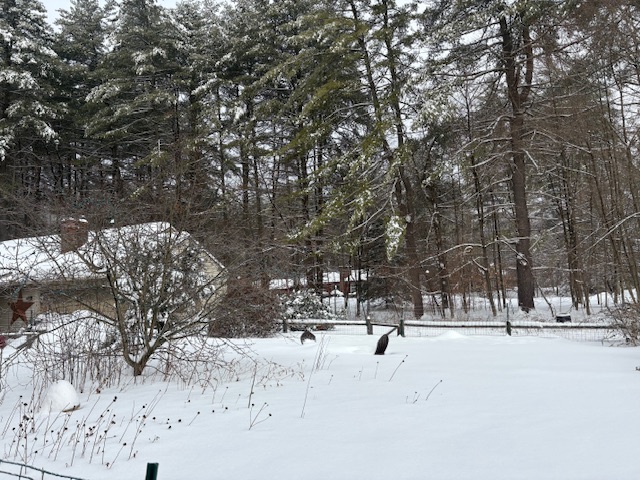
This is my deepest pack of the season right now. You can see those faux Adirondack chairs by my fire pit are buried.
.thumb.png.4150b06c63a21f61052e47a612bf1818.png)