HIPPYVALLEY
-
Posts
32,932 -
Joined
-
Last visited
Content Type
Profiles
Blogs
Forums
American Weather
Media Demo
Store
Gallery
Everything posted by HIPPYVALLEY
-
.25” at my house, which is perfect for the gardens. I was actually expecting to get Steined all week.
-
Hi of 82° today. I was expecting close to 90°. The sun never came back out in Greenfield after about 11am. Had a nice drink of rain around 4 PM.
-
We just don’t know.
-
I will be super impressed if a location out near Montauk can put up 101°.
-
https://www.yahoo.com/news/weather-news/articles/cottonwood-fire-ravages-utahs-eagle-152109144.html
-
I’m just watering gardens. Gave up on the lawn in the early innings this year.
-
Lawns are going to crisp up nicely. Not seeing any widespread precipitation in our future.
-
Yet still you can’t figure out how to post pictures?
-
Closing in on .30” now:
-
Nice soaking rain tonight. Hopefully the veggie garden goes boom!
-
Wut? It’s been two days and brief error messages. Maybe get an iPhone?
-
Yeah, toss that. Definitely some low 90s for a few days though.
-
1.5” 24 hour total for Greenfield
-
Nice puppies!
-
Steady light rain here since about 1pm. Just what the gardens needed!
-
Fantastic weather for the Green River Festival. Usually we get downpours or blazing heat. War and Treaty and Charley Crockett were killer last night. Kurt Vile, Spoon, Lucius, Geese and so much more coming up the next two days!
-
Decent wind with that line that came through Greenfield at 4 PM. Maybe 10 minutes of heavy rain but definitely some gusts that took down some small branches, etc. Sun is out now.
-
I doubt the valley is going to clear out. The breaks in the clouds in ENY do not really seem to be advancing east.
-
Yeah, I don’t see why you would need sunscreen at the beach a few days off the solstice?
-
62/50 on the N side of Greenfield.
-
You hate to waste a summer month with those temperatures.
-
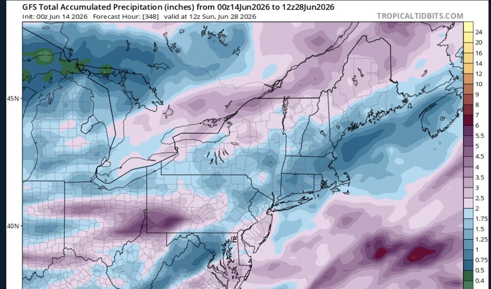
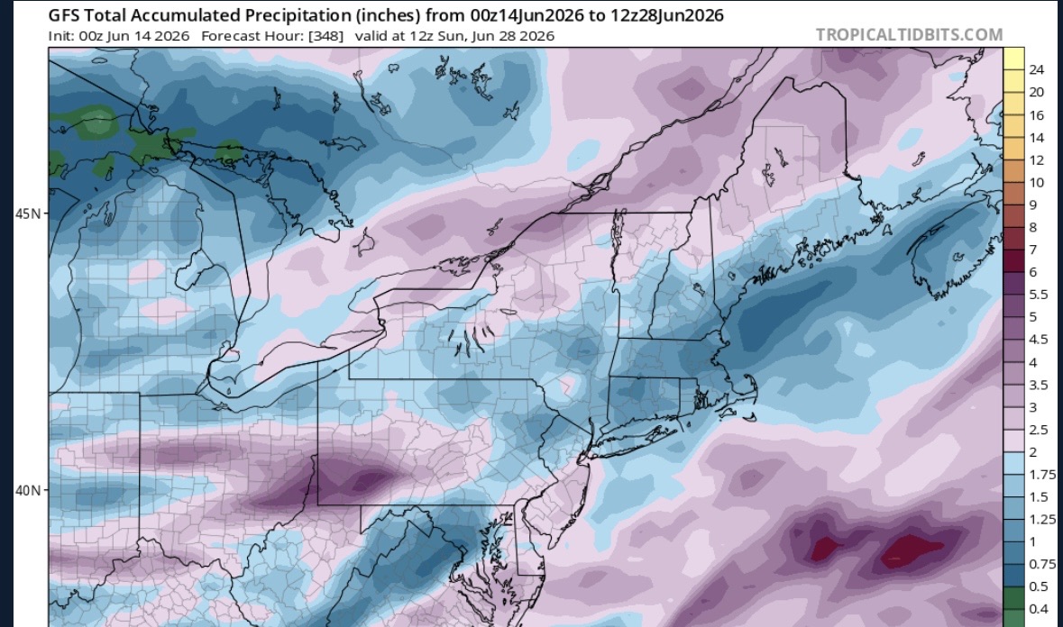
HHH may be back last week of June.
-
.30” here overnight.
-
Daily red flag warnings incoming?
-
Dry begets dry.