

Typhoon Tip
-
Posts
44,544 -
Joined
-
Last visited
Content Type
Profiles
Blogs
Forums
American Weather
Media Demo
Store
Gallery
Everything posted by Typhoon Tip
-
Huh ?
-
Not that anyone asked/cares but ..it's a win-win for me. We get the point across without actually losing power - ...err, so it seems at the moment. I don't know if the GGEM has veracity. 'The Euro comes in with that I guess we're headin the other direction. But for now, I'm going to go ahead and figure we successfully gleaned this potential out of the chaos, while preserving the ability to still f'um watch Football over the weekend. My house is all electric...heat, ... water... everything. If the power cuts, life stops. ...unless staring at a blank wall in the pall of interior dim is any kind of fulfillment that is. I suppose I could go out to my car,, plug in my phone's charger, and rely upon ' T - IMMobile ' swiss cheese migratory coverage ... but you know what I mean. I really don't like losing electricity for any calamity - exciting or not. Ice storms and Hurricanes are great until you can't make toast - novelty escapes really fast in that moment where you're runnin down your recourses ... checking off the but wait, can't-do that either list because of the rendering at hand. No thanks. 2" is plenty... Save the 20's for powdery cobwebs that shatters to dust around trees and power lines. Or, if it does snow 20 blue inches, just please by god keep the lights on
-
In a sort of conceptual sense... it might have been a 'one or the other' sort of correction all along? What I mean is, ...we are in a fast screamin' flow. It was likely going to express along a narrow N-S geographical spread, ...perhaps intense in bands then terminating pretty quickly outside a bit of a narrower corridor than typical coastal cyclogen - if this latter even happens at this point... yikes. But, point is, these progressive flows are "flat" - like, literally not just figuratively. They tend a stretch in the W-E coordinate relative to all scales and events within those dimensions. That doesn't perhaps lend to this being 12" of freakshow anomaly from N VT to Maine, and still bursting a 4-6" CCB collapse down here, which was sort of in the expression or intimation of yesterday's guidance. I guess correcting N or S, or just shrinking the latitude coverage may not be surprising is all.
-
Just curious what ur thoughts are: I'm noticing as this N/stream is relaying off the Pac we are seeing a flattening solution downstream... Is there perhaps an "over-assimilation" issue ? In the early 2000s... Boxing Day rings a bell ... it seemed this was opposite - sometimes a system would come and go in guidance, and be all but forgotten, then suddenly 48 hours out, it marches back inside of 4 cycles, and the key difference was the jet nosing - so it appeared so - from off the Pac over western Canada/Pac NW land regions where the physical soundings ..etc.. But, that was the last time that happened frankly that I am aware... Prior to that/then, it was more common to see an amplitude shift greater upon relay off the ocean/Alaska sector.. I wonder ... ( haha ) if there was policy shift ...where it is better to be 'over assimilated' and surprised by a whiff, than to be under assimilated, and suprised by a life threatening blizzard. Tho don't get me started on the Boxing Day storm ..LOL ... Anyway, the Euro may be interesting...
-
Yeah ...ah, heh... You know, 'new authors' don't tend to sell a lot. I think I sold 200 copies maybe? I'm due for some form or royalty in a month - first. Probably be 10 bucks hahaha. Frankly? I was not out to 'make money' - at all really... I wasn't. I just ... not to sound like a douche but people started telling me to write books in my 20s. ...then my 30s came and went and still, people would tell me 'nicely written' this and that... Meanwhile, I have no life and death is inviting - I decided...I didn't want to arrive at 70 years of age and wish I had done or tried to be something more than ignored. So, goal achieved - whether fleeting is the whisper in the wind, there is a trace of me left in the Zeitgeist I suppose ...Funny tho, it doesn't change the other stuff for having done so ...we all got our demons I suppose. Oh, it's on Amazon, "Dominion" is the name - which I don't like that title. But seeing as the publisher is on the contract, they get a say. - Turns out, there's a f'n "Dominion" title in every genre and subgenre already... I'm like, really - you dikks Further reading/observation about the book industry: In 1950 it was a bigger ordeal to cobble together a novel... All the moving parts, between editing and re-editing and reviewal... it was all done in solid state realm of machining/press. There was no Internet ( duh ) transmitting manuscripts, and no word processing. It was all typewriters, and red pens... and then USPS was more like 10 days to a month and there was no express anything... That was the 'express' That's how it was done... And, usually required sleeve-rolled, red-eyed coffee drinking Pall Mall smokers assigned chapter blocks in teamwork by recent journalist grads making shit wages doing grunt editorial tedium for maybe 10 "Dikcensian" publishing workhouses. While some chief editor did a final read thru after 36 months or something ... And, the tech in actually printing/binding books..? I mean, they didn't have Kindle ... the whole thing of it was a different industry then, and I have found that there is a kind of culture hangover, ...where people seem to carry a perception that it is some ginormous hurdle to 'get noticed' and achieve publication - ... Don't get me wrong... My publisher did tell me there's still something to it and they turn down a lot of manuscripts - yes... However, with such proficiency at both ends, it's easier for the industry to 'take a chance' ...
-
So you know ...not without compassion ..buuut, it does seem that the intent of recognizing the season's first chance at a synoptic snow as a singulare virtuosity might have gotten a little lost in the din of expectation ? Not really anyone's fault. It's a bit much to keep things in perspective, when the models timed .. cocaine solutions into the consideration ... like 12z yesterday, right when they did. Kind of encouraged this morph into a winter storm box as opposed to a recognition box. But, that's why this thread got going - because the models did that... I just hope the recog part doesn't get lost. This fast nature of the flow ...the N/stream part of this hasn't finished arriving over land up there in western Canada - Now...I am not sure "if/when" that old school data sparseness issue is/isn't even applicable, but... having wave mechanics actually physically sampled as opposed to detected electromagnetically from 23,000 miles in space ... seems better doesn't it. Ha! But it used still matter, even though the modelers at NCEP ( I think..) used to extol its virtue as being just as good.. That may be the case nowadays...
-
yeah ..I don't mean to come off like I'm offended or above having the shit kicked out of me - I laughed when I read your war and peace jibe and thought to actually post, " yeah, who was that asshole" ... I shoulda told folks ...well, warned folks that it may be longish .. lol.. Thing is, the GFS speed surplus has been in my craw for awhile and I was venting perhaps - ... It's also a speed surplus that is being sort of " hidden " by the fact that it is happening in a fast flow anyway - and that's really got me pissed off at it. haha.
-
Just my opinion, but I don't think Zeta really does much - It's plausibly dumping a huge diabatic source into this thing, but... the real difference between ...say a 00z NAM vs a 00z GFS oper. event, appears to be subtle nuances in the timing/orientation of the N and S/ stream, as the latter begins to integrate in a phasing/.. proficiency therein. The NAM was superb in harmonizing... The GFS was assonant - rotating southern stream positively sloped/and/or absorbing it in a velocity shearing mess. Positive slope/absorption = less DPVA ... These large synoptic wind stream variances would play out regardless of a wayward Zeta running up out ahead of it or not. Now... if the NAM solution comes back/or plays out... yes, having Zeta be absorbed into it ...or having its moisture infused ..etc., that would add to PWAT and other complex feedbacks ...but I suspect in order of importance, if one want to get a more upper tiered system ...do not do a GFS 500 mb evolution from 00z .. and that is independent of Zeta
-
Guys ...some people like reading - you're not one of them. Fine - don't read it. If Chris doesn't give a shit beyond the first sentence or two...that's okay too - but that's who it was addressed to. You're welcome to read that take on things if you like ... From a laptop/PC interface, it is not as long as you think - it's just that on a phone it 'looks' overwhelming -
-
Not shocking ... Each camp playing into their respective, persistent biases. The GFS stretched...The Euro may have been too deep... ( maybe in both cases!) ..but, your description does hearken - Furthering complaint: I've noticed a marked wind velocity surplus in the GFS operational model at middle latitudes everywhere in the World - I haven't bothered to analyze the GEFs members individually, or the mean therefrom, to determine if this is member specific but... the oper. version consummately ablates(ed) ridges in the summer, quite figuratively ( if not physically so...) rasping the tops off them with these 'rest state' huge westerly geostrophic winds in a grinding action ( jesus) ...like, over the tops of ridge arcs where the NVA should - if anything - offset and show some slacking. 75 kts 500 mb wind flow at the bottom of troughs would be 70 kts at 500 mb over the curvi-linear plain ... uh, okay. What makes that peculiar and perhaps 'insidiously' hidden, is that the flow is endemically faster than normal everywhere - like in actuality... In simple turn of phrase, it's a fast hemisphere, being modeled too fast - So, it is as though that natively fast-ish flow is 'enabling' the GFS and making it look right for the wrong reason...at other times, I'm seeing it have to correct back west with S/W translation timing when passing from latter mid into temporal boundary between mid and short range ... I have also noted, during mid August through September, the GFS was consistently 6 to as much as 15 dm deeper with hypsometric trough axis/quasi-closed cores trundling through the flow over ~55 to 70 N through Canada, comparing to all other guidance. It may be that integrating depth against the background subtropical canvas of summer giving rise to velocity - but this was also all true in winter last year. These are glaring biases that I really hope I get to see 'some' form of atonement as we near a release time for this Para- G/beta version. ...A model with a fast bias ... cloaked ( circumstantially ) by virtue of a hemisphere that really has been speeding up... And the global eddy really is mechanically faster - there's a reason commercial airline industry has been so frequently clocking historic, when not above average, ground-based velocity records when flying west to east over oceanic basins and over continental landmass.. everywhere. There was one flight last winter or perhaps the previous ... ( I think 3 hrs and 50 min rings a bell but don't quote me ! ), between LGA and LHR over in London - some sonic speed relative velocity. It's because they're up around 200mb level taking advantage of a gradient saturated hemisphere in the winters ...and I'm virtually convinced it is the expanding HC into the lower Ferrel latitudes ...causing height compression and anomalously high/balanced wind response. But, it's doing other things... For one, it's distorting the R-wave residences and making the entire systemic 'gears' around the hemisphere less capable of blocking - or blocking becomes more ephemeral when it does occur. I think one of the reasons why we are seeing lower -NAO frequencies in the last 10 years, when the multi-decadal EPO/AO/NAO is/was supposed to be tipping negative, is because this velocity richness is impeding/distorting the 'fragile' nature of the NAO domain space... It's suppositional at this point - but may be intuitive in a purely conceptual wave-mechanical sense. But, it is also causing storm behavior/morphologies that are subtle...at other times more gross. There are more 'busted ravioli' type precipitation events ... blown up and smeared across the synoptic plate, where we have lows in multiple nodes along baro-c axis .. Also, often bigger temperature variances astride boundaries in transition seasons ... 80 next to 30 with no storm in a vicinity..because the flow over top is so screaming fast no S/W fan mechanically force jets to even initiate over frontal slopes keeping them stable... But when they do, overrunning becomes favored over the Norwegian Model variation/classic. And, then! When the latter does occur, interestingly we are seeing historically deep pressure cores ... it's like it takes more to overcome a canvas of velocity, but when it does, the other steeper gradients ignite bombs plumbing to category 3 hurricane likeness... ( See NS/NF last year for example..), and they tend to be fast movers. It's like the sped-up flow is favoring less mid grade cyclones ... "in low" ( haha) of either overrunning or hideously violent bombs. Anyway, this thing with the NAM solution at 00z actually is a singular example that exactly fits this above... If that solution comes back --> materializes ... you have a near historically deep NJ Model bombogen running out under LI ... And, historically deep anything after mid October with a marginal atmosphere is going to over-produce in the Z range of the sensible sounding... It's just a potent system overcoming a fast flow, and such that it operates closer to the upper complexion of power and expression and we get tarred and feathered for it... These are like hypertension ... silent killers ... I know these observational trends are true et al, ...I am not entirely certain it is climate change related, but strongly suspect it is so... And, it's probably endemic to this part of the acceleration therein... If the HC continues to expand...the Ferrel circulation will start to break down - gradient slackens and we're warmer overall < 60 N ... But, by then ...permafrost has lost it Methane and we're really in a world of shit... because the Oceans are probably no longer fixing C02 as proficiently ...and that's the ball-game. It's easy to say that won't happen in our life-times ...but that feels like a cozy euphemism and/or bargaining/evasive tactic ... particularly when the changes we are observing in the environment now, have outpaced the climate modeling from the 1990s by some 20 to 30 years! This fact should not put bricks in the foundation of people's confidences as to where this shit's going - but... this whole missive is now a 1,000 words more than you wanted to read if you've even gotten this far so - I appreciate your candor if you did. lol
-
That 0Z NAM solution extrapolates to a thriller… You’re talking mid to upper 40s light rain crashing into the low 30s with snow falling excessively with thunder and unfolding wind conditions. It’s through 985 mbar and the best Q-G forcing hasn’t even caught up yet; and already the rain snow line is smashing Southeast through the region at 84 hours; that is prior to the former’s best mid-level forcing then passing through so it’s like you’re going to get a massive burst in the snow column on that solution/evolution Unfortunately the caveat emptors with the NAM apply… Right? For one it’s handling beyond 36 hours sucks. Two it tends too much amplitude in this time range with northwest bias‘ and overly negatively tilting troughs – often lending to too much of a northwest position. ...but it’s a subtly more difficult a call because this solution frankly ... I don’t think it’s very much different than what the UKmet and Euro were attempting 12z. in any case that’s going to be anomalously ferocious if that goes to 90 hrs
-
It’d be nice if one of these held serve from inception in but that’s never the case ...there’s always a run or two that backs off if not completely turns off the dopamine drip and everybody goes running for the Bridges
-
This is kind of typical… After the first 6 to 12 hours of euphoria starts to wear off people run out and go find the model runs that don’t look very good and all the suddenly it’s grouse time lol
-
Meh...this is still out there ...no sense in having/getting one expectations up first place but if your vested already - it's sort of silly to be ...
-
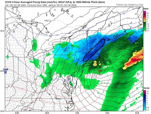
Lol ...The ICON is a 'Rorschach' test
-
It's the girl of my dreams standing before me with a subtle indentation of her va-goo-goods visible through her fashionable skin-tight yoga wear -
-
Lightning in this band The trouble is...it's the ICON - which I don't care to comment on it's individual performance? however, this isn't too far strayed from the Euro/UKMET and Para-G complexion of near or at flashing of the column from near wet bald z rain ( actually probably 36 or 37 is the magic flip number ...) to blue dusk job, but this thing's liable to head for 30 and under by 9 pm easy. This could be really bad for the evening commute 18z to 00z as the band probably pivots SE through 5 pm - but ... with Pandemic traffic demography is probably manageable. Anyway, that deck to 1300 ' temp collapse prooobably catches civility off guard as antecedence at this time of year ... I suspect it won't even occur to many to bother looking - it's not supposed to do this in the first f'n place
-
Lol ... right, agreed - But, you know ..I'm of the school that jesus, we're even talking about this ? It's worth of attention that we have this rationally happening regardless - it substantial in and of itself already -
-
The Euro is passing out of 'radio silence' on this run and it's likely it needs another cycle or two to lock on the signal - ..it may morph a bit more and is flux. I wouldn't take the details of this run verbatim at D5 ... but... anything after 00z run you'd be wise/safer to begin that consideration - The problem is, despite Kevin's protestations and vendetta to vilify the Euro ... it still outperforms other guidance < D4.5 over the longer termed statistical coverage -
-
uh I dunno I suspect we see this sort of thing in the D8-10 ranges out of the GGEM and Euro ..but they keep ending up correcting to more NW trajectory over the mid latitude continent as those days get more 5-7 ..and on and so on..
-
The operational - one might think - must be a southerly outlier by some ...
-
hah...wow... I love how the Euro has it going over 80 F on D10 in the greatest warm frontal intrusion since a laundry scene outta Shawshank Redemption
-
It did cross my mind a couple hours ago honestly haha But, I don't know/think this is much of an analog - I'll have to take a look at the NCEP library and maybe study the UKMET and Euro - ..seeing as these have now acted like 'Johnny come lately's showing up and bullying the show away from the Para G ... 'Hey, look what we think!' ... which was the first to hone this specisivity during a generally favorable 'super synoptic' era we've frankly had signaled since the end of September ( imho ..) .. But yeah, 2005 was a compact 45 unit v-max that was so extreme over a small area, the whole system ( also a fast mover...) really fit inside "meso-beta" scale - sort of a derecho sized cyclone with an excessive graphical zenith in power. It folded the troposphere ... it's dated enough now that it may be worth it to discuss - that was extreme stratospheric entrainment event, with a huge surplus of very dry lower stratospheric air sucked into the gravity well along the back side of the wind max, and when that mixed with the saturated backside of the CCB and really created a huge downwelling wedge of gravitationally accelerating atmospheric weight... See you later Cape Cod! boom... 110 mph wind gusts I think? But ... the sun set was visible. the whole thing was 6 hours out here in interior eastern Mass, and we actually saw the sun set, with 12- 15" of new snow and people wandering around looking at the sky dazed and confused...
-
Something like that... In this case, it's really the very powerful Q-G forcing nosing over the Bite region S of LI...and that UVM forcing triggers a redevelopment back SW along the baroclinic axis.
-
Sometimes this happens... If we're going to dump over the threshold into an exotic SD scenario ... usually the conventions fly out the door and the region just gets the shit kicked out of them. This "could be that" - ... having it got to lightning and thunderclap, blue-tinted dusk in 5-7" of parachutes, then...fast clearing by 9pm with starlight radiational crazy glue dymonds - I just friggin joked about that ..I think to "Hoth" ? ... now the Euro tries to do that exact joke ? I'm heading out for a lottery ticket... lord


