Typhoon Tip
-
Posts
43,454 -
Joined
-
Last visited
Content Type
Profiles
Blogs
Forums
American Weather
Media Demo
Store
Gallery
Everything posted by Typhoon Tip
-
December 2021 Obs/Disco...Dreaming of a White-Weenie Xmas
Typhoon Tip replied to 40/70 Benchmark's topic in New England
Your ICON model loads a SWFE snow CNE up with implications for at least some ice inter SNE at D 4.5. Not a particularly big fan of this model… But it underscores the point I was just making I feel -
December 2021 Obs/Disco...Dreaming of a White-Weenie Xmas
Typhoon Tip replied to 40/70 Benchmark's topic in New England
Mm there’s a fly in the ointment for an out-and-out warm shits pattern though. Variance is getting rather extreme across the mid latitudes of the continent, N-S across that mean polar boundary. Your mixing and snowing within 50 miles on the N side … nearing 60 on the S. Moreover, it’s vacillating like an unmanned firehouse every other run. The reason for that is because (we discussed this earlier ) the +AO/ strong PV structure is displacing/biased axial node(s) toward our side of the hemisphere. That’s a crucial bias; it changes the map a bit. It’s compressing the height south and offering all kinds of confluence contention … also pressing cold air unusually far south under very fast Westerly mlv jets. If it were not for that we probably would just go inferno… but at least day 5 through 11 or 12, I don’t think it’s going to be as cut and dry as a straight up Pacific dominant pattern. It could … sure. But there is hope for winter enthusiasts. -
December 2021 Obs/Disco...Dreaming of a White-Weenie Xmas
Typhoon Tip replied to 40/70 Benchmark's topic in New England
D10 looks unrealistic ( Euro ..) but that overall between D5 and the end of the run ...that's a wild 5 days of changeability. Much in concert with what we were just discussing, with a very fast, gradient saturated environment between southern Canada and the OV... D7 is a SWFE --> Miller B that happens so quickly that there's really no time to change that event from wintry to straight rain in the interior - ...but christ details at this range for that type of synoptics is utterly futile. -
December 2021 Obs/Disco...Dreaming of a White-Weenie Xmas
Typhoon Tip replied to 40/70 Benchmark's topic in New England
I would rather not experience two light-moderate events where I am being "de-membered" ... but we're all in here for our own reasons, I suppose. kidding, but you know...some of it has to do with being used to getting snow earlier in recent winters ( I wonder). One gets that 4 out of 6 years of goodies, they kind of start wondering where it is when that inevitable seventh year may come back to normal. I can tell you growing up between Michigan and SNE and throughout my adult years, ... man, the 1980s were absolutely butt bruising trying to get a white x-mas done. Not because of Grinch this or that either. It was like planetary-screwed... It just didn't kick in until after xmas, and I was told by High School teachers ( dating myself - ) that I February was our big month ... and from what I had experience through the early 1990s that was closer to realistic. Thru that time, we only Currier&Ived maybe 2 white xmas ( I think ). Otherwise, a lot of brown ground ...sometimes frozen ground, Decembers of boredom lore - I betcha we wouldn't be having this discussion if this was 1988. We would be making winter predictions for Jan - Mar. -
December 2021 Obs/Disco...Dreaming of a White-Weenie Xmas
Typhoon Tip replied to 40/70 Benchmark's topic in New England
Ha ha ha... well, keep in mind, ... we're sort of in making chicken salad out of chicken shit mode here. It's like, what we got to work with.... but it at least it isn't zero. Namely, the biasing of the PV on our side facets. Remove that, and we may go December 2006 really fast. Cross that bridge... Until then, this is misleadingly balmy ( as in, not as much so as it may look at a mere glance):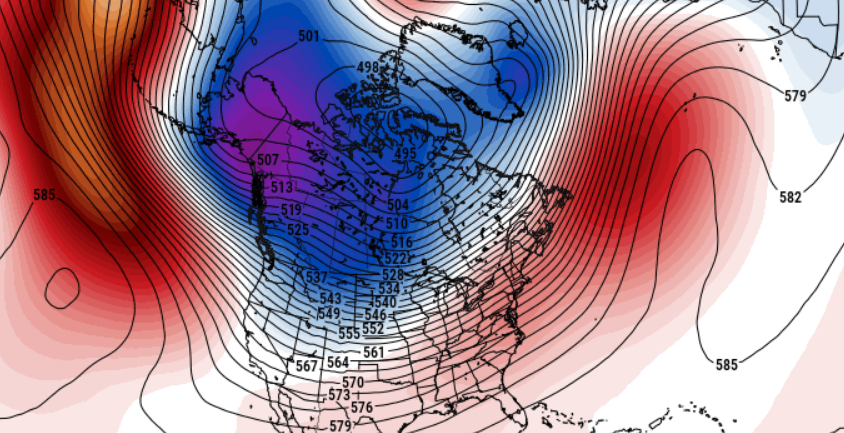
-
December 2021 Obs/Disco...Dreaming of a White-Weenie Xmas
Typhoon Tip replied to 40/70 Benchmark's topic in New England
Well... the current D10 EPS ( 00z last night ...) polar stereographic layout is a whopping +AO... But, the PV is off center wrt the geographic NP... That sort of skews the extent of the positive anomaly down a few decimals or even a whole SD because the AO domain geography is fixed, and then the EOFs are calculating the atmospheric aspect as they move around that fixed 'umbrella' ...I think it extends down to 67.5 N but I'll have to look that up again ( I always forget needling things like that...). Anyway, point is, ...it's a powerful +AO in that D10 layout, and since it is on our side of the hemisphere ( biased ), that avails/enters a colder look to the NP but warm in the MA... as you noted, the gradient between the two is rather extreme. As far as what it takes to 'bridge' - well... for one, lets weaken the PV/ lower the Arctic Oscillation. The GEFs evolve the hemisphere similarly, but skewed/biased west overall slightly of the EPS. I don't see the EPS beyond D10 - Scott I think mentioned that week 1 of the Weeklies may segway off that range...etc... But, the 12z GEFs layout is similar to the 00z re this subject.. In either EPS or GEFs ... it is interesting because both have this +AO displacement look, with the lower nadir height node(s) off center the pole toward our side. The GEFs in fact does this right out 300+ hours. In either case, the PV is in tact, more so than not. I don't know if that means no winter-like corrections to the dailies, though. That crucial displacement/bias on our side, means confluence ( to me ...) episodic across lower Manitoba-Ontaria-Quebec. The storm track will run up under that and you're right - could be you know like 15C variance at 850 across 200 miles of baroclinic zone as it probably rolls waves along it. Almost wonder if if 'icing' chance are above climate... But, if end on on the south side, we go above normal ..big time. The mid latitudes are f'ed hard from the Date Line to off the EC, so ... this subtlety about the AO may be the only hope. -
December 2021 Obs/Disco...Dreaming of a White-Weenie Xmas
Typhoon Tip replied to 40/70 Benchmark's topic in New England
You know what ... I get why your saying this buuut... storms have had a tendency to over produce. In fact, it's been getting rather dependable. If a storm looks middling, you get more points embedded that majored. If a storm looks major, you get like what happened to Brian last December...etc... you know? So, if Dec were to punt even up there... three storms could quota the winter norms inside of a 12 days in January, and you'd still have that perfunctory March yard stick storm up there. -
December 2021 Obs/Disco...Dreaming of a White-Weenie Xmas
Typhoon Tip replied to 40/70 Benchmark's topic in New England
Yeah... and like Will mused, not the whole way ...but much of the time. This has been happening more frequently since the early 2000s. As an aside - which I find totally cool man ... - there has been recorded, a marked increase in near or at record air-land relative speeds set over the oceanic basins in the last 15 or so years. I mean, think about this physically ...a 60 ton aircraft has to fly at a certain speed to maintain enough lift to offset gravity and keep in suspended at intended altitude. If not... those on the aircraft tend to 'Value Jet,' and they don't want that - ..heh.. Anyway, keeping it simple. For head winds, this creates lift at relative throttle position, because as the aircraft moves into a headwind, that arithmetically moves mass over the wings that the engines don't need to provide by forward thrust. When going the opposite direction, this becomes negative, and the aircraft has to thrust more - fly faster relative to the ground - in order to push the same mass over the wings and create that lift. SO, ... west to east flights have been haulin' ass. There have been like ...3.5 hour LaGaurdia to Heathrow London flights. It's been pretty interesting. -
December 2021 Obs/Disco...Dreaming of a White-Weenie Xmas
Typhoon Tip replied to 40/70 Benchmark's topic in New England
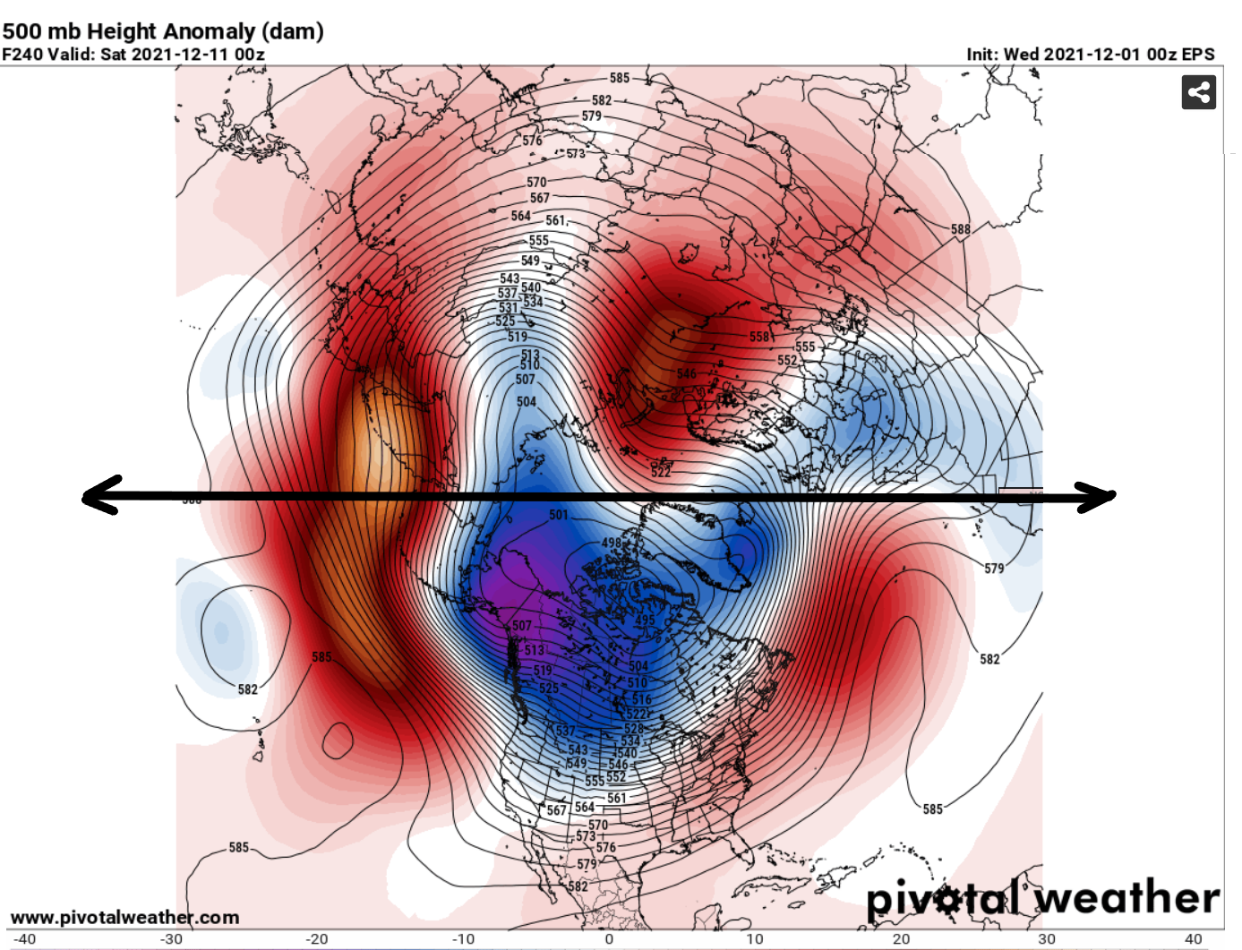
Boom! exactly dude - we laugh uneasy, because that was a problem. In fact, I know why that happened last year. ...or at least I really have a hypothesis. Opposite of what is happening now ( since Nov 16 -> how long it lasts, notwithstanding). Something I have been noticing as of late ... the lion's share of colder height anomalies over this polar stereographic perspective have been over our side of the Hemisphere... Below is the D10 EPS mean just to make the point, not a forecast. And it may be too much of a good thing so to speak. This was the other direction ...I think the western Pacific through Siberia was very deep in heights last January, ...during that 2.5 week span in which we saw gradient become perhaps too relaxed as you intimated... Why? who the heck knows...but the 'global wave #' might have had something to do with where the PV tended to slip off the axis - if you will - and meander to where it did back then, and recently.
-
December 2021 Obs/Disco...Dreaming of a White-Weenie Xmas
Typhoon Tip replied to 40/70 Benchmark's topic in New England
Perhaps ... perhaps not. But the specter of winter 'abeyance' is certainly there and trending... I realize you were probably answering back to the prior poster's pessimism/hyperbole/jest to some degree. But ... that AA phase of the Pacific is showing up in both the EPS and GEFs after Dec 8-10 pretty brightly. There are differences between the two, in how the westerlies orient upon approach to the western continental forcing, but by and large, I've seen big warm ups begin that way. Rising heights N-NE of Hawaii, when both 55 N and 30 N are fully integrating ...doesn't typically go too well for winter enthusiasts over eastern N/A. With modest negative anomalies in the EPO domain space? The prior posters 'hyperbole' is understandable if not necessary. I mean I don't give a shit... I really don't. I see it objectively and just say bluntly what things looks like. Of the two below, I'd personally weight the PNA as 80% of the forcing ballast in determining precipitation and temperature anomaly distribution, and let the NAO modulate like Robbin in the Batman relationship. Lol. Anyway... What I'm seeing is that the verification (vague green curve ) has been well-enough aligning wrt the bolder black line, which is the verification. So, the telecons have been verifying reasonably well. So what can we glean from that? Good question - ..we just got done musing in that Winter thread, how these telecons have seemed less able to drive said P and T distribution, as a recurring confidence rattler. I think we just suffered that, actually... If you look back along these respective curves above, note November 16 through very recently: in that span, we saw a rise in the PNA, and a tandem fall in the NAO. Normally, ( in 1980 ..heh ), you move the PNA from -.5 SD to +1.5 ( or a near total index change of 2 SD range), there is some kind of larger scale synoptic distorting perturbation requiring a restoring event - ...that means, a storm lol. Yet, these were ineffective index modalities - which I find interesting. I think we got the cold, part of that.. My personal suspicion is that the observable base line wind velocity, which really in theoretical arguments means the heights are compressed ... , as being pretty culpable in limiting how individual wave spaces behavior, can interact/force against that background canvas - it gets really heavy Meteorologically having to take someone through vorticity equations ...but if the ratio between the larger synoptic value, and the individual wave-space value, approaches 1 ...that means there is less ability for cyclogenic responses in the atmosphere. Well...anyway, ... when the flow is compressed, it is fast, and this robs away from the small scale impulses. 'nother way to look at it, the above +PNA/-NAO movement was below the threshold, a threshold that requires greater anomaly magnitudes when the flow is compressed.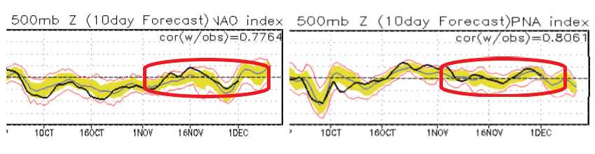
-
December 2021 Obs/Disco...Dreaming of a White-Weenie Xmas
Typhoon Tip replied to 40/70 Benchmark's topic in New England
For general readership: If perhaps more so for numerical convenience than anything else, NOAA climate convention situates December cleanly as a winter month. Not intending or desiring to get into any qualms about it ( I realize the discussion is personally skewing - ), but, winter = DJF, spring = MAM, summer = JJA, autumn = SON. Obviously human conventions vs the year-to-year atmospheric behaviors seldom align. It "seems" like folks bend opinions based on the advent of entertaining model solutions, and/or whether there is snow of air and ground, as metric for winter. If people use "snow" as a winter determining metric, then some years winter starts in February... Other years, in October. We could either go that route, and just have it annulled every year when winter happened to begin and end, if ever. Or, we can be grown-ups and just except that winter = variability that ranges from shit we like to shit we hate, and shit in between, and that's just life - but this latter tact takes the fun and 'purpose' out of this engagement, huh. I'm sure Will or someone of the like could crunch the numbers and figure for the last 200 years. Create some sort of mean snow-density graph. My hunch for NJ would result like Jan 14 to Feb 20 as a scratch conjecture. SNE is oh Dec 26 to Mar 6 say. NNE might be Dec 3 to Mar 24 - 'Course, the last 20 years probably stand out as a disruption - more so than any other 20 year period in history? One wonders... -
December 2021 Obs/Disco...Dreaming of a White-Weenie Xmas
Typhoon Tip replied to 40/70 Benchmark's topic in New England
I won’t typically get involved in that sort of thing but where is this troll post? - ‘nough energy spent in it finally triggers morbid curiosity heh. I mean I just scanned back a few didn’t see anything that antithetic but perhaps I missed it. -
Lol "useless nodes" ...exactly, 'snicker bars in the swimming pool'
-
Boom! you know ... I think it's been screwing with the teleconnectors, both dependability ( they are unstable in signals ), but also, because the velocities, +1 PNA and -1 NAOs... -1 AO whatever, they don't seem to materialize the distance mass-field forcing as obviously.. It's almost as though the telecon domains have to get more anomalous strong to get to the same forcing as they use to. -1 NAO west based doesn't exert here the same way it used to, when the Pacific is pointing space shuttle thrusters at us... so to speak -
-
Cool .. but, as intimated in that - I wonder if the 'strength' of coupling can persist. Once the compression maelstrom of the ensuing deeper cold season kicks in, that may alter the landscape a bit. I actually agree that the base-state right now appears as such - for now...
-
Oh I was being hyperbolic and snarky dude. lol.. I mean, there's a some truth in dark comedy - but I wouldn't submit that to the AMS for publication either. Yeah, I don't know about DJF this year as confidently as last, honestly. For the Oct/November thus, I am seeing hallmarks in the hemisphere for more La Nina, agreed there - does it last? mm I think we are advantaged, thus far, because we are in the blurred distinction era between standard autumn and deeper winter. In this space, the gradient of winter isn't maximized just yet.. so it's mitigation isn't happening. There are evidences now - like literally this last two weeks --> - that the hemispheric velocity is increasing though. Once the latter truly envelops the hemisphere more fully, I wonder if that - again ... - is when the ENSO contribution begins to get damped/mask beneath the compression/velocity soaking. It's simple theoretical Meteorology, which deals with wave mechanics in the atmosphere. If the velocity in the ambience increases, that intrinsically changes the wave resonance... Well? if that's true, we can't expect La Nina to 'force' the same way as it did when the velocities were more like mid-last century. It just means these ENSO has to be contributory along a newer idea, hopefully statistically demoed at some point. It is noted ... the 2nd year of cool ENSO's tend to drive better - again, the problem I have though, that was/is based upon a pre-HC expansion era... Personal posits: I've always thought that the HC would get in the way of the El Nino forcing, more so than the La Nina ( * believe you and I had this discussion last year in the main forum somewhere's) ...the circulation of the expanding HC is - counter intuitively - weaker, not stronger. Growth in the cell does not mean it is stronger in that sense. It's probably something more like the same mechanics, but spread out over a wider area, so it moves slower. The wider HC band/slower circulation, isn't mine, btw way - it's in a growing bevy of accredited papers. Anyway, if the ONI is in concert, that means that in spite of the HC, the circulation is still breaking down KW propagation allowing easterlies to dominate. So that would be my suggestion - keep an eye on the ONI ... I do think that at times the La Nina will present, but I think we will have other times when former gets in the way. That's what I'm leaning. Unfortunately, this is just a comment to the characterization of the flow/expectation ... I don't have a f'n clue what this will do to snow... ( although as we were hypothesizing in the other thread a while ago, the fast flow may shred wave structures, and rob lower tier events. ...etc) ... I think storms will tend to move fast, and if we lost to weak waves we could make up in having more of them - there's that too. We should also note, the HC expansion --> speeding up the hemisphere by ambient gradient, .... that's not all or nothing? These are moving amounts, week to week and probably more like month to month.
-
December 2021 Obs/Disco...Dreaming of a White-Weenie Xmas
Typhoon Tip replied to 40/70 Benchmark's topic in New England
And the confidence is a hard on, huh -
December 2021 Obs/Disco...Dreaming of a White-Weenie Xmas
Typhoon Tip replied to 40/70 Benchmark's topic in New England
The Euro trended pretty heavily toward the GFS for that gig next week... That's a polar warm sector for SNE on just this one 12z cycle. plus, it's likely over-amped - like I just got done saying... - but how about -30C over mid Ontario D7 poised and ready wow... and right after we get rain, too - perfect! -
December 2021 Obs/Disco...Dreaming of a White-Weenie Xmas
Typhoon Tip replied to 40/70 Benchmark's topic in New England
The other aspect that's as fun as a splinter lodged in the rib area of a sweater's fabric is that these individual horizon emergence' ? They unrelentingly become less and less as they get closer and closer in time. Maybe not on a straight diagonal to hell but the end points invariable seem to feature a verification that is downsized - -
December 2021 Obs/Disco...Dreaming of a White-Weenie Xmas
Typhoon Tip replied to 40/70 Benchmark's topic in New England
But are we kicking the can ... It seems both warm and cool pattern looks are being pushed off in lieu of just oscillatory and uninspired. -nice -
Occasional Thoughts on Climate Change
Typhoon Tip replied to donsutherland1's topic in Climate Change
One wonders if that can really end very well ... https://www.cnn.com/2021/11/29/americas/xenobots-self-replicating-robots-scn/index.html -
Wait - what was urs ? Mine was like this... Bookending -NAO/-EPO tendencies, with hyper fast shearing flow in between... and patterns that only coincidentally look like La Nina when they do, but a 'blizzard' of posts running to the bank because they just couldn't wait to evidence it as ENSO-caused, when the real cause for the winter behavior is CC gradient destroying the previous climate dependencies... So maybe a run-on sentence ... haha
-
December 2021 Obs/Disco...Dreaming of a White-Weenie Xmas
Typhoon Tip replied to 40/70 Benchmark's topic in New England
ah yeah... that's an interesting veneer for it - LOL -
December 2021 Obs/Disco...Dreaming of a White-Weenie Xmas
Typhoon Tip replied to 40/70 Benchmark's topic in New England
Yeah I was a considering the exact same aspects but ... the thing with this progressive nature to the flow ... the "correction vector" may actually be less supportive of the UKMET. it sucks sick of it. like everything just tries get around the planet immediately when it emerges -
December 2021 Obs/Disco...Dreaming of a White-Weenie Xmas
Typhoon Tip replied to 40/70 Benchmark's topic in New England
It does ... no this is an excellent point. ( EDIT: oh ..ha. I read "Earth" as "Euro" ... haha sorry. But hey - both balance ) The Euro's 4-d variable system is all ooh and ahh sounding and all, but what it ultimately achieves is 'smoothing' - or attempting to do so .. It tries to mute unwanted 'spontaneous emergence' along the way of processing. They are natural bi-products of complex systems operating in time ..etc..etc.. But, they then propagating onward to seriously f-up a total outlook when they do - or can. But, the only problem with that is,... sometimes the emergence are real. Chaos can't be ultimately, entirely de-cluttered; noise is a real aspect of complex systems, too - to wit, the atmosphere is definitely representative. lol. I suspect that's why crossing D5 to D7 in that model routinely takes trough and ridges and ends up adding to their anomaly - in either direction, ...by some percentage. It's basically canceling out the features that are negatively interfering, then the feature in question gets a surge for 'virtual god' ( if you will ...) washing the processing by shedding those mitigations.