Typhoon Tip
-
Posts
44,567 -
Joined
-
Last visited
Content Type
Profiles
Blogs
Forums
American Weather
Media Demo
Store
Gallery
Everything posted by Typhoon Tip
-
It depends what is meant by that in the above excerpt. Warm can be a subjective term... If the author means, +1 over normal.... ? Sure, I'd say there is a reasonable chance for that - semantic gaming implies 'warm' in that sense. But if you're intention in borrowing this statement from a [probably] much larger qualitative analysis is to 'sell' 80 - hehhh... nope. There is no way a boundary pinned SW connotes that. In fact, from this range, that could be like the scaffolding for 50s insert at some point.
-
- that too, yup CC is as much a sociological forcing, as it is forcing species migrations ...pandemics, screwy growing season. Freak synergistic oven events like the that which took place over Pac/NW last June ... and elsewhere with alarmingly increased frequency over the last 10+ years. Hell, maybe even eventually here one day. 107 at Logan, 4 days in a row, with lows no lower than 88 F over downtown boulevards of urbania in general. It's not as dire an impact as those latter effects, no ...but part of CC is perception. That's a rabbit hole. People have less awareness. We have not had that kind of 'synergistic heatwave' here ... if perhaps yet. I'm presently bunning myself .. mm hm but ... those hyper heat events are still popping up during the globe's summer hemispheres, like rogue wave phenomenon. The other thing ... I wonder if the yawing back and forth into transient nape smacking cold is effecting people's perceptions. Or if the ballast of 'warmer than normal' is owned by the nocturnal lows, while highs are muted by pancaking and/or rain timing... Then, garnished with those 1.5 day long cold smacks, ... the above normal gets completely invisible.
-
Boy ... warm enthusiasts that understand synoptics must be none-too thrilled by the prospects over next weekend. Warm front moves bodily to Pennsylvania axis, slams to a halt, This above (left) is as close as the surface boundary apparently gets, while then watching the warm ridge roll underneath. If that thing ever got NE of us, we'd be 84 F. Nope. It's because of the train wreck in the N. Atlantic circulation mode. It's a -NAO that is biased over the eastern limb of the domain. ...Technically, that should be enough room to allow the OV ridge to expand in ... maybe even fend off the BD eddy... But the models are cutting off a spring block E of CC like we used to see in the 1980s ..interesting. Anyway, that vortex gets pinned S NS out there, and that's the ball game. If that moves out more ...the warm air comes in.
-
probably not gonna be taken very seriously .. .but this month's behavior - to me - smacks like a global warming month. It's basically when the month is normal relative to the direction of delta(climate), perhaps not normal in a linear comparison with Aprils of last century. The problem with climate inferential efforts is that term, d(c). Changing climate means, ...it is mathematically unstable to compare a moving target, against a historic one that was more static. It's also why these seasonal outlook efforts ... I fight rolling my eyes, because every year people take from all these linear arguments, 'ENSO was x,y,z in 1954. Because it looks similar in the present day's seasonal climate modeling ...", etc, the winter forecast gets weighted accordingly. I don't know if I like that presumption. But this is also a digression... All I am saying is, ... experiencing an April that doesn't "feel" above normal even though it is, one that is also dappled with enough rain ( April showers?) ... to be a bit above normal, while no hydro pathways reflect surplussing... all seems like how climate change hides a normal month.
-
the issues with Tuesday's system ...likely failing the blue bomb deal, are bigger than just cold air. The N-stream is actually bullying in and only partially capturing... That's bad, because that behavior forces the westerly track,...but also does not really phase in enough to deepen it enough to where the whole structure can 'carve' SE a bit ...which would then go back to a more east track with a deeper total result. A latter scenario might actually do a dynamic flip deal.. But this is perfectly not right, as is.. The fact that the antecedent air mass is marginal - only - then does the rest. Because if there were more BL resistance/cold in place, that can force a deeper system and more d(t)/ p-type compression. It could be 'blamed' on a season tenor but I don't see this really "like" much that happened earlier this last winter. This is got broader systemically failing matrices involved. The models are not doing anyone any favors by painting any blue colors anywhere, because it's ginning up the hopes and maybe dreams that really probably don't have much hope of materializing. Unless the models are wrong about these limitations, and there's a cold destiny still lurking ? that's just having a gambler's addiction waiting on that probability to parlay. This is likely a typical climo April chilly rain coastal ...whether it ends up the Hudson or comes over Boston...it probably won't make a lot of difference anywhere < 1200' elevation, and restricted W-N
-
Euro wants that ..
-
Species matter of course... ...you ain't growing cucumbers now - no way. Tomatoes might survive, but that particular vegetable has bad recovery after having been stressed early in growth.. If you plant in marginal temps, they may stunt later in life. There's a ton of lettuce, herb and legumes that are cool preferential, however.. In fact, you can season those varieties, rotate the earth/fertilize and still season staples like cukes and toms.
-
So... there seems the underpinning gripe-memes for the day, no spring snow event? If so... meh. It really had lower odds of actually materializing. Sure, it's not zero. I mean..folks will claim they knew that and intellectually, they probably did. But they did not covet that belief. They latched onto the NAM's NW bias as still plausible on some level, ignoring the bias. That, and how it was only backed by the GGEM. Time of year and how models, in general, tend to over cool mid range as a spring error ... etc. No hope would have been more apropos. Then, we wait to be pleasantly surprised. It's tough to do that, I know, when folks have evolved a kind of emotional/'joy circuitry' turned on by in particularly, [the anticipation period], prior to a modeled event that features... whatever weather they want. In this case, snow. As an aside, I believe fully it is connected to that same sociological phenomenon covered in the "Social Dilemma" (NETFLIX), ...I think back in 2018. Similar phenomenon.. only here, the stimulation trigger is the models' creating storm cinemas via lucid access with media technology at people's disposal. The engineers of IOS have come out and admitted the psychotropic entrapment was the goal and how it works(ed). Fascinating - That's all sounds heavily clinical sounding ...maybe even damning, but it's not all that either. It's really about 'tendencies' to do so. Personally I'm lucky. I think I experience similar triggers from scoping out heat waves and other summer phenomenon, just the same. Speaking of which... how about the 00z Euro and GFS toward next weekend? It's -NAO emerging on the eastern limb of the domain region up there. Which in tandem with a modestly negative PNA ...I'm wondering if as the time nears, these operational runs are positioning the super synoptics more in favor of an eastern warm up - emerging in time. If the -NAO repositions more W ...the jig is up and we'll go the other way hard probably. Unlike last Decemeber, the present circumstance would find us influenced by a much weaker Pacific jet coming underneath from the W. We'd probably end up with troughing/cut-offs in the area. But if the -NAO stays more easterly limb, then westerlies may correct N over the eastern contenent - it seems to be trending that way. Seems also like we've been dealt reverses like a game. No sooner does one make model observation of tendency, the next model runs seem to deliberately go out of their way to mock the effort.
-
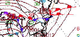
Here's a classic blue bomb ...ho man - pleezy weezy with sugar on top. Particularly because if you roll this series of GGEM charts thru, two days later there's a huge warm dome setting up
-
Who ... me? I said the word "April" in the post - if other, never mind.. But either way, one should think about "seasonally" - not by month anyway. Months mean nothing in nature. The context and fair interpretation is the concept of snow late, and not thinking we can escape that. That's the point.
-
Hehhh ...I understand the notion ... ( soupcon of frustration in hand throwing - haha), but I don't believe it's that far gone. ...yet. Like I said, and is true, the number of May days with snow in air - whether accumulated or not - in the last 20 years is up over the previous multi-30-year average trend. That's code for having more of them. There's large -scale circulation theoretical arguments that it could in fact be related to CC stuff...but that's not as important as it is that those incidences of cold very late, merely did not time synoptically with a storm system. Regardless of why ... I don't know if we'd should believe we are protected from late storms.
-
Excellent point... In fact, I was snarking about that, but as a seasonal tendency/model correction necessity earlier in this morning. The models will tend to over-assess the b-c gradients, because they were too cold to begin with - something about the seasonal damping effect of the sun is not modulated correctly out in time. I see this every year - I'd be fascinating to talk to the modelers/engineers down in NCEP about this ...and how/when the Euro or GFS tend to flood D7+ < 0 C 850 air masses down to 35 N like a full radian sun gets weaker out further into April?? Coastal comes along and it's February in the model's imagination. I'm being sloppy there a bit but you get it - Thing is, we can't discount it happening, either. 1987... 1977 ...1997 ... flurries in recent Mays? It's just narrowing the margin for error. Probably we have more of what you are mentioning in anomalous dosing ...less interference...etc.
-
Yeah...same shit that's effected all cold, multi-stream determined systems spanning the last ... 10 years really, and that is that the N stream needs to either phase the f'er or get the f outta of the way. The partial thing isn't always good. We can get away with mangled p-types and/or lollies for vicarious living in the winter, but in spring/marginality season there's less room to negotiate.
-
A curious description ... as the 'i' and the 'l' in that euphemism mean "i'd" and "like -to" ...specifically as it pertains to the like-to aspect... it's hard to put toothless in the same sentence there - interesting choice.
-
adding to consternation ... the NAM has a NW bias beyond 48 hours with polarward turning coastal cyclones/synoptic waves in general. I've said it a thousand times, but we don't seem to put that into our filters, do we - soon as any 84 hour NAMs-day-device paints blue ink on a QPF layout, here comes the procession of posts playing bargaining head-games over how it won't happen - LOL... To be honest, despite my own proclivity to rail on about the month of 'Anus' ... I do carry a soft spot for these face smack blue bombs. If for nothing else, the Schadenfreude ... (wah wah wah) But quite seriously, like Will just said ... not much else going on, but there's another aspect for me. Which is ... Summer is still coming. No matter what the atmosphere is doing to try and stop or deny celestial mechanics, the power of the summer solstice is going to win. Unless Yellowstone erupts or there's a meteor impact... but yeah, who cares. It's probably going to be close to 80 the week after. It's really an opportunity to enjoy a winter storm's beauty without any longer termed hang-overs often experienced in mid winter, post event, endless doldrum hell. The storm is in, it's silver dollar pancake aggregate socks blue tinting the 34F air mass down to 1/4 mile... and the next day, the suns out and the streets and roof eaves have steam dogs curling around each other... No harm, no foul. You know, when I was child in Michigan the farmers referred to that as 'farmer's gold' it's a nice nitrogen fixing late charge into ground that is not frozen - so it actually gets into the dirt stratum. Tilling begins as the snow retreats back across the fields.
-
Next week's cold expanse of air N of Tennessee seems a bit heavy handed by the Euro though. Not sure how thru that 72 - 96 hour period, the Euro keeps the air mass -3 C as far south as the Ohio River, under April 18th/19th solar when there will be low cloud count. That of course sets the stage for the latter coastal, that gas-lights the local consortium of snow dorks that can't seasonally let it go... Ha, but I wonder if all that's falsely too cold conserving. The air mass should moderate. Kidding a little there ...but I wouldn't be surprised if that air mass gets modulated up some. The dailies may not end up as pessimistic because of that. These cyclones in that latter mid range, at this time of year, ...can be over engineered based upon the model's own cold bias' faux enhancing baroclinic gradients. We'll see... I will say, in the last 5 years, I've seen packing pellet flurries in May, twice. And probably 8 or so times in the last 15 years in general. Those have occurred regardless of leading winter this or signal that, air, land or sea. It's probably part of the seasonal lag shit/ CC .. Either way, clearly we just need to time things better and there we go. I don't a give ratz ass if it's been 80 already, either. Whether the patterns have delivered warmth or not is no vector.
-
Yeah today and tomorrow have been on the charts for awhile as sneaky nape days - before the other shoe falls on more typical New England spring BS... Right now it is nearing utopia outside. 63 F with very light winds, with that purified kind of translucent blue that allows the sun an edgier heat sensation. You walk under and it's instant. The 850 mb is around 6 C ... And so an 850 mb adiabat is roughly 73 or 74 in the 2 meter T, but I'm not sure we'll get the BL that tall...Still, with light WNW component adding some d-slope physics maybe we can go over the 68..69 machine numbers. Who's complainin' though. Tomorrow is the same sort of scenario but more clouds around probably so some limitation.
-
Mulch reminds me of an anal retentive OCD neat freak that would normally keep it in the home, but having taxed the other household inhabitant's lives to the brink of sanity ... they have no other options. So they bring their oppressive, 'ruler to palm' smacking nun neurosis for order and fear of masturbating outside the home. Such that instead of allowing nature to provide organically occurring splendorous patchworks, they get to exert their compulsive sense of orderliness and oppressive policing over the extension of their domain, too - which ironically is what gives them a hard-on.. To say nothing of the fact that it's horrendous for the environment but it is what it is...
-
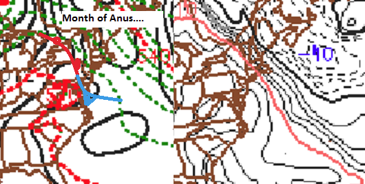
I'm singularly impressed ( actually ) at how well this warm frontal sag/BD combination was predetermined by the guidance. Picked up on it days in advance really. I'm wondering if the warm frontal/synoptic sagging helped them by 'guiding a BD in' ... either way, there are definitely two boundaries in reality, though WPC is only analyzing for one of them. Either way, right down to the dimensional layout from three or four days out .. is pretty damn good considering the meso-beta scaling of this. The PP S of and N of SNE is essentially the same. There really only one factor promoting this set up today, and I suspect it is curl around the topography. Flags around here are dangling without much wobble. It's classic month of Anus still mank
-
-
Never under estimate the power of the BD side of the force
-
Occasional Thoughts on Climate Change
Typhoon Tip replied to donsutherland1's topic in Climate Change
Just a pure scientific curiosity: ...I wonder what kind of safety protocols would have to build into such devices that capacity ginormous storage - star in the pocket. At some point ...charge density makes an object a veritable bomb - what happens in instances of catastrophic failure? where does that go? -
It's interesting to me in these situations ( ..because I'm a self-masochist...), there really has to be two boundaries in play, but WPC only physically analyzes one type - here, But if one observes morning satellite cloud behavior/motion and combine it with Wunder's temp layout, there argues for the quantifiable 2ndary structure nosing in from the NE that both does and doesn't align with that. CT and western MA are in the 50s, that's the front we see abv... but this bell of 40s and misty phage into the east/NE is differentiable to that. It is a distinctly different air mass. It's probably like an outflow boundary kinematic ... but in honor of the butt bone damned, it would be nice if we got our memorial badge on the map!
-
Yup. Red Maples are rusting big time too
-
broad leaf sugar maple