

Typhoon Tip
-
Posts
43,440 -
Joined
-
Last visited
Content Type
Profiles
Blogs
Forums
American Weather
Media Demo
Store
Gallery
Everything posted by Typhoon Tip
-
These are real leaners ... The tops are ripping off and sending down stream almost as soon as they breach the altostrata heights -
-
Unbalanced climate anomaly … There’s only one way to correct that … go the other direction. Question is, do we do so cumulatively over a span of modest events … or in a greater short duration extreme
-
GGEM looks pretty similar to the 00z version, actually . Fwiw -
-
It's like the Euro just gave up attempting to stop heat...collapsing like the Celtics in a 4th quarter. This below, with the exception of maybe Caribou Maine and Spokane Washington, the entire contiguous US is 90 or above ( obviously not in the bays and estuaries ..but in general) I'm not sure that's ever happened at this scale of pervasive coverage - http://www.meteo.psu.edu/fxg1/ECMWF0.5_12z/f240.gif
-
I wonder at times if that adjective ever applies around here... But I guess if we mean prolonged relative to our climate? Sure - 2 days instead of 10 minutes... we don't see that either. GFS is also - as an aside ..- relentless in its pursuit to limit heat here to one day. It'll sometimes balloon a non hydrostatic ridge that's truly awesome, ...go look at the surface evolution, it's 12 hour of heat and it has a big sfc high wedging in the back end, while holding back warm fronts forever in the front. It may not be right - per se.... But, since we get f'ed out of heat anyway apparently at least excuse imagined, the model's technological evolution is at least heading in the right direction
-
What is ? Today, tomorrow ...or Sunday - You have three disparate sensible types rolling through. I guess it almost seem useless to the point of nihilism to even expound up either, when neither can persist around here long enough to matter.
-
You know... in the myriad of internal voices that combine to create the total din of internal thoughts this morning ... this occurred to me. The "Year without a summer" - 1816. Tambora had ignited such wonderful displays of sunset skies during the presaging times since that volcanic throat tried to pop the top of the atmosphere and send a geo-belch into near orbit... In a symbolic way, those splendorous distractions were like nature's "red light" to stop and take notice - not merely art. So the consequences set in ... and in that year without a summer, annuls that pertain to New England: 'frost was observed in every month' - I mean check that, but I'm preeety sure I read that took place. But what came to mind was that when we discuss climate change, we are really only discussing decimals over the course of a 30 years. Well, perhaps whole degree(s) at local climate scales - but over the global integral..etc. So, the 1816 summer failure took place in world where the temperature declined by all of 0.4-0.7 °C (0.7-1 °F). Which doesn't seem like that much - right? But that little amount meant frost ( and probably 3,500' elevation snow if any civility were present up there, in that era). So what I am getting at, even though ( and no doubt!) the next IPCC report will continue to doom humanity, as well... , NASA will report June as number 2 or 3 all-time hottest Junes since our species could give a shit) it doesn't thus intuitively 'seem' like we are so far gone up the scale that we can't f'up a summer in New England. Jesus christ.. . Frankly, I have never seen a weather pattern behavior so tediously petty in creating cold inserts reasons, specifically targeting Logan airport, such as I have seen happen in the last 5 years... And of course the surrounding region going down with it's like collateral bonus damage. We just cannot seem to "be allowed" to experience what the world has been - meanwhile, we have to capitulate based on the overwhelming impact of nocturnal anomalies... ?
-
It's a transition pattern, though. Caveat emptor on that "zonality" In a scalar sense, sure... I've seen the operationals and ens means; that's the gist of the blend. However, the various sources that cover/forecast the mass fields indicate a PNA that is going ↓ ...gathering more weight - so a trend to get more so too. It appears to me the different operational run "extended" ( in quotes because it's nebular and not necessarily the same amounts among them in space and time ) ranges have been resisting that mode change. The last EOFs provided numerical values that would sufficiently signal more ridging potential ( for a change ) east of 100 W than we are seeing. That's not intending to refute the flatter look, despite the subtext ... I mean sometimes the operational runs, ..particularly when they agree, can win over the telecon/ens mean. But just means to be leery. It matters re heat and convection trajectories is all... The PNA is supposed to be losing (seasonal) correlative value but.. I don't find that assumption to be necessarily "AS" true as say 30 years ago. Little longer hypothesis ... My personal speculation is that as we continue to evolve through this CC era, that is related to why we've been observing unusually strong mid latitude/ mid troposphere geostrophic wind velocities ... lapsing over into springs later and later in recent decade(s). I feel that CC is causal in that emerging aspect ... ( whole 'nother popsicle headache as to why, and this write is already stressing the attention of the reader in this on-setting zeitgeist of tweeting virtuosity ... heh, an entirely separate kind of climate evolution). Gaslighting parentheticals aside ... ( lol ), the logic goes like: faster wind --> wave construction --> R-wave structures. That maintaining coherence later and later, means the telecons correlations mathematically have to persist. So the ultra short version, the PNA ain't dead yet. That said, I'm wondering if we may see the zonal start looking more ridgy over the eastern continental mid latitudes.
-
Not a particular fan of the ICON myself and thus haven't seen, but .. per your description that sounds like July 2-3rd last year.
-
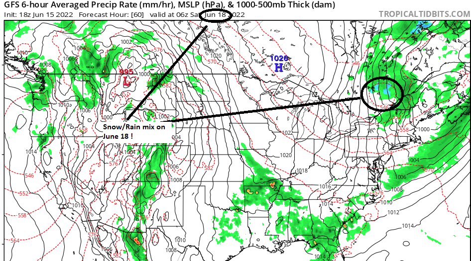
Why are you bunning me? that's the model doing that - I didn't run the f'n thing in my basement. That's what Ray was talking about . If reality conflicts with one's personal narratives and motivations or whatever, they impugn. It's silly - the G F'n S is snowing in upstate NY... deal with it
-
Depends on the scaling, actually... In terms of absolute value, no way - it could be -20 diurnal 'IF' the GFS' various fantasies play out, and there's no way we've been +20 yet. That said, it may be hard to get +20 in a June ... climate doesn't really permit that. Otherwise we'd be 95 to 100 far more frequently. So based on climatolgy ... mm, I'd still say this cool snap is deeper negative than the positives we've had - however much so. Just off the top of the head...
-
It actually splashed mix QPF down into upstate NY too...
-
Like to see one of those heat signals get to even D6. I think one will .. the eventual/onset -PNA probably does exert to a threshold and the circulation mode across the continent snaps away from that weird meridional flow thing we're observing - but ...it's not clear this would be the breakthrough look.
-
...it's like the Bubonic Plague of super cells, "the black death outbreak" muah hahahaha
-
Summer solstice snow as nearby as NF... Granted, it's the Canadian but you know ... I remember the sardonic jest a couple years ago in a post, words to the affect of '...the models won't stop until they succeed at snowing in June,' when extolling the very obvious oddity that's become a leitmotif ... A recurring theme/tendency to attempt to do this below. Meteorological spacing? That's next door.
-
Aauuh... . This isn't 1994... Day 4 is a little more dependable.
-
Yeah ..good sleuthing re the NAO "idiosyncrasies" I mean I was really just responding to the poster who mentioned the a spring that's been negative 2/3rds of the time. It doesn't show up in the numerical/EOF derivatives - in fact the opposite. But sure... if the NAO particular details have to work that hard to f'up the numerical signal well shit then - it only underscores my point from 10 years ago that the NAO is vastly over- f'ing rated. Positive numerical curve looks like a block N of Maine? That's a "nested anomaly" that skews the correlation - Yup, we'll see on the speculative -PNA forcing, tho... It's taking a long time to settle the positive mode off, but it is not cross the 0 SD terminator. You know, as an afterthought ... the PNA's correlative weight diminishes during the summer - but that is a distinction based prior to CC attributed seasonal lag of stronger ambient polar jet tendencies. Simple circuitry: strong westerlies --> lingering R-waves ... --> means correlations persist. That simple chain of logic to me means the PNA isn't shut down just yet.
-
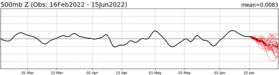
Actually... now that I look at the history over at CPC, re the NAO ... that distinction does not appear to be correct. The NAO has in fact, since March 1, averaged positive. There have been few negative interludes along the way ...but it "looks" in the range of 57 vs 43%, positive vs negative weighting. Which leads me to my on-going contention and consternation regarding this trough incursion that slices along the NE coast that I've been musing about for days - it has/is not really been very well supported by the NAO ... which just spent the last ten or so days decidedly positive and only looks to gradually decline to neutral. That is not a "park deep vortex between Maine and NF" signal, in fact...quite the opposite. We should be stretching the flow and sending ORD heat right to Caribou given this recent history: https://www.cpc.ncep.noaa.gov/products/precip/CWlink/pna/nao.gefs.sprd2.png ...It seems, despite the fact that the PNA index is supposed to go to correlation sleep this time of year, it's modeled presentation could be more rooted in the non-linearity of wave forcing off the Pacific ..as seen imm below. That's two weeks of solid +PNA... The heat in Chicago and surrounding region of the conus is actually NOT a good fit for where this curve traversed, but it could be why we are also seeing this big rolling buzz-saw carving along southern Canada going forward thru the week. There's conflicts in the mass field forcing. The subtropical ridge signal is clearly attempting to bloom - perhaps ahead of climate/seasonal signal ... While this over active polar jet, which does fit the +PNA, is imposing that anomaly from the top. It's interesting... And then who can ignore the weighty -PNA out there... This is what has me disturbed a little for bigger heat problems. There is vastly more negative soil moisture anomalies over mid latitude conus than the other way around leading, and if the +PNA does collapse and reverse modes that heavy handedly, the erstwhile STR signal becomes unimpeded. We could see constructive interference much bigger ordeal than just a Corn Belt/lower Lakes... Just waiting on the operational model to come around. Lol, they probably will.... Sep 3rd thru the 15th ...then again around Xmas
-
That MCS apparently split … The models didn’t seem to see that happening, the S aspect having made it all the way S to the Gulf it now has turned back west along the coast down there.
-
Uh well pulled it off an NWS product fwiw -
-
Chicago is 100/70 right now ... wow -
-
Looks like the Euro's not quite as cold aggressive as the GFS cinema during the latter weekend thing... It's also trying to marginal heat surge into the region D8-9-10 ...ways out there and likely to be mangled by future runs, but just thought I'd add. I'll tell you though, Corn Belt/lower Lakes, IN-OH region may see some truly insane heat numbers D6 and particularly 7 in this run. Indianapolis in the area of +27C at 12z 850 mb ...That's before diurnal mixing, next Tuesday. That's easily a 105 look
-
4th of July last year was of that ilk in chill ( Sunday...) ..heh, not having to go far back to see that it can happen. I think of it as relativity scopes, though, and it may be part of CC ... who knows. But I find it more apt to happen now, then 30 years ago, where we get these freak cold inserts with diametrical air masses west across the continent, while it is happening. I have allll kinds of rhetoric that explores plausibility as to why but... in the interest of popsicle headache and empathy, just go with it... Anyway, it would not shock me in the least if we get that Sunday Monday cool snap, then send the mercury into history the other direction a week later. The dramatic yawing between ends of the spectrum is also consistent with this era, more so than 30 years ago.
-
wow... obs across N IN and SW lower MI are commonly 88/79 right now...
-
Yesterday ...about 7 pm, was like euphoric. It was 83 still with a DP of 55, with zephyr breezes by and by. It's difficult to imagine Earth could provide any setting more of nerve-settling splendor than that submersion in a nostrum bath, under a flawless evening sky.


