

Typhoon Tip
-
Posts
44,233 -
Joined
-
Last visited
Content Type
Profiles
Blogs
Forums
American Weather
Media Demo
Store
Gallery
Everything posted by Typhoon Tip
-
Sky’s day glow. Sun orb dim viz. Dead calm. 63. If the sun actually comes more fully out it’s gonna be actually spectacular with the colors out there
-
In an unrelated observation I don’t think I’ve ever seen my lawn look this beautifully green and pure in essence of that particular color tone in the 10 years I’ve been associated to this property – and that’s amazing considering two months ago in the height if all the drought futility
-
Yeah this part of interior northeastern mass rarely experiences meaningful wind in a southerly gale scenario - or results least. Nashoba “Valley“ so much of it glides right over the top the friction inversion. Despite being in the low 60s ( one might think at this time of year that would be warm enough to mix ) all night there wasn’t one audible gust over the rooftops.
-
Fwiw -
-
Right and so if we hang up the AO in a negative state this winter that would be a breakdown in that correlation. But none of theses are 1::1. duh.
-
Interesting… And just adding to the conjecture – in keeping with the threads title. But it’s funny how we’re in an era ( I mean like over a decade in length ) where these longer-termed, broader scaled teleconnectors seem to correlate less obviously, at times failing coherence… It’s been occurring greater frequency than their mutual correlation coefficients What I mean by that is… ex: the AOs meander away from QBO correlation. Or these extended span of times during winters whence the apparent circulation mode of the westerlies decoupled from the ENSO state. Etc. Pretty sure there is a multi decadal AO that follows the solar cycle – seldom do I hear it discussed in here but the correlation is out there … I’ve seen it graphed and written. It’s positive, such that when the solar is down the AOs tend negative and vice versa. We’ve definitely been down in a solar extending along … I think it’s a 23 year oscillation… The 11 year mins were embedded in that 2ndary differential … such that they were more min than normal min () if that makes any sense. Yet since 2000 the sign of the northern annular mode has averaged positive? that might be a long winded bad example lol But it also seems a lot of negative AOs failed to deliver cold, as an after thought so I guess the overarching theme to this whole thing is that it’s adding headaches to using linear correlations to project what the indexes may do based on historical inferences and analogs, because the emerging hard-to-ignore unstable domain borrows from confidence
-
Word
-
Do you think that might’ve been a little bit of terrain enhanced? The wind trajectories were sort of SSE pretty much thru the 700 mbar. Maybe not appreciably strong but that was a pretty high pwat air mass being humped over the terrain. Ha Kind of gross but where it humps it dumps
-
So it looks like if anything the models were too wet? I didn’t pay too close attention to this because it didn’t look that extraordinary to me. I mean the deep pinwheel over the great lakes/associated trough is for the time being sort of stationary while trying to send this lead side frontal construct through us… I mean the dynamics and mechanics were what they were but it seem like you weren’t really differentiating the field enough for it to be an extreme event– that’s just sort of a canvas for this. Admittedly with shame… I looked at the NAM FOUS once we were inside of 60 hours at ALB/LGA/BOS. As a quick and dirty technique I’ll just average the triangulum between those points off the gridded QPF. I don’t recall seeing values very much north of 2“. I mean obviously that is a crude method in today’s era of reasonably accurate meso analysis at less than 40 hours that can expose embedded heavier activity etc whatever …basically this was a slow moving warm conveyor transporting saturable air under attenuating mid-level mechanics… That synoptic appeal combine with those grid numbers was good enough for me
-
Might be an understatement, too. But we’ll hold pending how that evolves. The signal’s emerging boldly though. I’m sure you’re aware… Some of these recent euro runs, ensembles and operational, began disrupting the resonance between roughly the date line of central pacific through the longitude ~ Chicago … despite the MJO actually moving into phase 6 and trying to get into 7 from those same sources. It’s been a bad year for the MJO - man just cannot seem to couple with the atmosphere. They also began doing that while the GEFs members have been maintaining a pretty strong positive PNA. So there was a conflict there beginning to emerge – all this is really just the last three or four days of guidance tenor. But the signal is more coherent through all sources this morning including the GEFs …beginning to slowly seesaw backward. You know … it’s almost like the current look with this trough in the east… coming to a nadir sometime between Monday and Thursday of next week ( wouldn’t be ridiculous by the way if we get a chilly rain coastal with elevation blue out of that - I hinted that in a one sentence drive by post the other day…) is being handled like ‘the winter expression before the Indian Summer’ typology. I mean snow’s a human convention in all that. Philosophically it’s whenever the pattern seesaws from early chill back to summary regime - right? Perhaps it’s getting rather late in the climate change slow moving apocalypse for the early chill signals to actually have snow in them lol Seriously tho I take longer range warm signals for some 10 … 20% more weight as a standard approach. Whether it is because of climate change or not … the past 15 years those tend to over perform the majority at global scales. But I’m also on the fence a little bit because there is that other aspect that long lead model images of that nature also tend to be over amplified so you’ve also got conflicting concepts going on there interesting.
-
Curious what their respective reason were. I had figured for a season being some kind of lower than the gushy mainstream media’s reported counts ( which is technically different than ACE ) … tho I didn’t care to engage in any kind of discourse in the matter last spring tl;dr attitudes in modernity ‘bloated with virtuosity for real and profound engagement’ … definitely fosters motivation for poignant composition whether the counts were low or ace was low leans on a moral victory ha My reasoning didn’t incorporate solar this AMO that … i’m sure that stuff has a numerical significance when using linear approaches to the statistics over extended periods of time and is probably just as valid. I just kept it simple and was looking at recent papers regarding how climate change is affecting the circulation medium all over the planet -,admittedly a lot of those discussions are actually mirroring some of my own observations that I’ve been writing about here and elsewhere… Maybe it’s just coming to a similar conclusion via different means. I think I did post some hints that I didn’t think would be a very good season along the eastern seaboard which at the time was related to the same reasoning regarding circulation components of the hemisphere earlier last spring. you know as a somewhat unrelated matter to this discussion, but perhaps more important to the purpose of this thread … it might be interesting if we have a surplus of OHE in the gulf and adjacent southwest Atlantic up the eastern seaboard as we plumb deeper into the cold season. You know maybe we can actually get one of these cold surges to kiss that with some bigger deltas
-
You folks do that in the basement … interesting.
-
Uneven distribution where the inversion is lingering… Lotta home stations already in the mid-60s short distance to other sites hesitating in the mid 50s this hr
-
That's a winter cutter aspect, the 'ribbon' echo squall line. So many southerly gales end by means of one of those from later October through Xmas in the climo of this region. The Dec 5 2003 snow storm was preceded a week earlier by DPs near 70, transported by southerly winds gusting to 55 mph which was swept out by a frontal system/squall like that. Two days later ...a polar front brief 1/4 mile vis squall where I lived in Winchester, followed by a deep cold incursion. I remember it was 9 F at 8pm ..maybe Dec 2 ? Then, boom
-
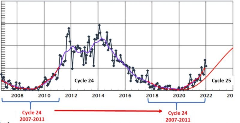
Signal of interest between the 19th and 22nd.
-
Milder incrementally the next two days... Probably 4-7 F warmer for most, relative to region tomorrow. Then, at least that much again Thursday. In fact, the NAM is all the way to 20C at 980 mb/above the 2 meter sounding slope, so it's probably more like 23C walking out to collect the mail or driving down a town thoroughfare with the windows half down. Not sure about NNE but they are encapsulated in the same general synoptic circumstance so likely a warmer than normal day there, too.
-
Yeah… I’d also add that it’s kind of modulating warmer than it looked two days ago - we’re talking about this week one I provide discussions for weather firm and I had pointed out in there last week that we seem to have competing aspects going on in the models. This morning beautiful exemplifies that with that trough later this week now looking completely neutered not even making it to short term actually… The hemisphere is trying to be anomalously convoluted and unusually amplified earlier than normal while at the same time normalizing as the near terms approach. -this is probably related to the fact that all models tend to be over amplified at those extended ranges …maybe Anyway these late middle range early season outbreaks end up being rather tepid by comparison, when verifying. This last weekend is kind of an example - we still managed low to mid 60s as our ping highs; the model charts from last Monday or whatever you would’ve thought we would be upper 40s to mid 50s tops. This mild looking week is kind of doing it with the actual pattern not just with the 850 mbar smear
-
Mmm. And it’s behavioral aspect actually showing increased deltas in the last 15 to 20 years… simple terms, greater variance than is normal variance even for autumns… You can include springs in that too. Most obviously and likely related to you know what - Though the Y-coordinates” would cement eyes shut in here so futile to write what nobody reads
-
Considering that 70 or 80% of the months since the year 2000… during the recency of a climate change’s “hockey stick“ rise…, have all ‘winded’ their way to being above normal (however extreme notwithstanding) it’s a safe bet that demonstrative trend would continue. As winter weather enthusiasts we naturally hold out for that 30 or 20%…lol. But, it becomes even less likely to total glorious winters when needing 30 or 20% return rate to succeed all three months of DJF. Taller order But that is in deference to temperature. Most involved in this engagement are actually after the experience of snow… And I would argue just based on my own experience interacting over the years that it’s mostly they are after the drama in the cinema as it’s provided by models and meme, preceding the snow - but that’s another discussion. As far as appealing to that motivation…we can also be decimals above normal and still have a very severe winter with some nested extreme cold outbreaks… couching significant winter storms. To that end we really only need five or six decent events if not two juggernauts, to get a snow total above seasonal normal. In a lot of ways February 2015 nicely illustrates this concept when considering that winter as a whole … But in this era of elevated pwat due to climate change, helps that. So there’s some interpretive argument there where enough in between days are warmer than normal that a month or winter mean on whole may statistically belie the experience.
-
Yeah I wasn’t asked but … the notion of its usefulness being that it characterizes early behavior of the field is essentially right. At a somewhat more discrete level… from what I gather, lagged statistic correlation to winter suggests that whatever the environmental factors producing early proficiency are, … they tend to last. Think of the study as exposing the tone setter - It just doesn’t really delve deeper into what those factors are the last I had looked into the matter… The correlation like all correlations in nature are not one to one, either. There’s that… plus without knowing what the factors are makes the correlation in general rather shaky as a predictive guide.
-
Impressive diurnal. That is also an aspect of autumn climo … bottoming out at night and than rocketing in the afternoons. delta 27 so far. 35 62
-
I was surprised there were not Headlines in place heading into last night down here in interior and/or climo-prone SNE areas. I don't believe we'd had a frost or freeze just yet? convention was always, will issue 'until such a time as one has already occurred' Maybe I missed one...
-
Here's a brief anecdote ( if moral), check your Provider rates. It's a column usually on the backside of your N-Grid billing statement. Probably similarly placed on most bills regardless of deliverer - NGrid, Southern Energy .... Consolidated Edison, Duke Energy etc... That field on your bill has recently (over the last 10 years) become the most important. It used to always be the delivery charge that was the bigger of the 2. Rather interestingly ... (if not dubiously) the Provider has switched to where the arithmetic (decimals X the average household 1600 hrs), has crept over the delivery service charge - and the gap is growing! Apparently happening 'under the radar' of people's notice. Sorry this became a little longer than I meant it... but I think it's interesting: Case in point. A year ago last summer ... a couple of "SE" (Buffalo, NY) supplier reps were patrolling our neighborhood, stalking schmucks. I admit, I did not sense the predator. Their sale's pitch for .13 kWh was - quite embarrassingly, I admit ... - just a vague reference to some aspect on an electric bill in the moment. Maybe it was more of an intuitive sort of thing, like ... "Yeah, supplier provides the actual electricity - I know" You have to understand the whole history of the individual in this case. I had always been lucky enough where ever I lived, to not have to deal with an electric bills ...Since taking over that responsibility in recent life, where I live, my home happens to be all electric. Heat, water-heat, and stove/oven ... and everything else. So a bit of higher number was dismissibly acceptable ... Kind of like a 'slum dog millionaire' effect, only not winning. Losing That all changed when I opened a warning for disconnect by N-Grid last April, for an outstanding arrears on the order of 2400-and-change. Ummm.... Turns out, that .13 number they were selling lasted until Dec 1 ... more than doubled while everyone was distracted ... This happened to others on my street. It also happened to a friend on mine, ..sort of suggesting its more pervasive; a very similar sort of dubious unrepresented rate hike - not SE but some other outfit. Anyway, doubled or more. So there I was, paying my 250/mo ...while the lapse was was reapplying to the total bill. I'm not one for wild conspiracy theories...but I suspect nonetheless that there is some design behind doing that. If you are the average schmuck just trying to keep head above the overwhelmingly vast, uncategorizable chaotic sea of modern distractions... Companies have caught onto that 'drowning' distraction, and leverage it to their greedy advantage. I think we all know this... Cable companies began doing this decades ago, with big entry deals ... After some time goes by, a partially transparent and very small text appears somewhere on a billing statement, indicating a rate hike ... while the Trade Towers were falling and Pandemics and general dystopian media for stimulus junkies were becoming the zeitgeist. Next thing you know, your 75 buck/mo sweet deal was ballooning to 150, and since you were on auto-deduct/e-transfer protocols with your bank, you were susceptible to not realizing after a year of it. You now owe them a testicle. Of course, x-y-z company was perfectly willing to keep rolling the difference back into your acct principle so long as their getting their 75 - until they tap you on the shoulder to collect. They get to tell you, 'We notified you by mail.' They got you by the ballz. Done deal... The other aspect that is sort of borderline collusive about it all... Climate Change. yup - I suspect that supplier companies are raising rates ...claiming it's because of supply and demand which is a lie. It's really because they know that 90% of energy is still being generated by fossil fuel consumption, a practice that is going to end in 20 years or ... humanity - pick. This is their exit strategy on that industrial dying ways and means. There are technologies out there that blow your mind. Scientists have found ways to create electricity out of the ambient air... Plus, fusion has been sustained in Tokamak research for the first time in recency. So ... tell 'em 'that will never fly' one day.. matter of time. Somewhere between those necessarily viable innovation solutions projects an entire power grid that is fundamentally different in both infrastructure and supply, that most likely ...sans the SE's and the Duke Energy's and the N-Grid's of the world. They're cashing in to cash out in other words.
-
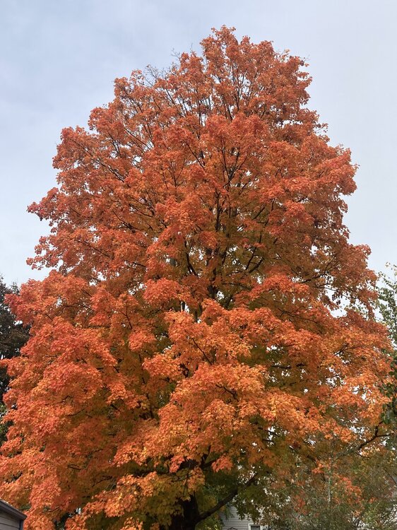
Just about right on the climo button for color-up around this are of Mass
-
"It doesn’t hurt here. I doesn't hurt here. It hurts riiight here"


