

Typhoon Tip
-
Posts
43,330 -
Joined
-
Last visited
Content Type
Profiles
Blogs
Forums
American Weather
Media Demo
Store
Gallery
Everything posted by Typhoon Tip
-
Y’all droolin over the 18z GFS? Three 6”ers Xmas to NYE no melts between
-
December 2025 regional war/obs/disco thread
Typhoon Tip replied to Torch Tiger's topic in New England
My dad told me a story growing up in late 1940s… Had an ice storm like that across Southern lower Michigan. This is long before the current kind of infrastructure or even highway system was nearly as evolved as it is now so probably lacks notoriety but anyway. He said that after about an inch and a half of accreted ice, it transitioned to snow and they had 8 inches on top. That’s something I’ve always wanted to see - a major on top a major -
December 2025 regional war/obs/disco thread
Typhoon Tip replied to Torch Tiger's topic in New England
Yeah, I mentioned ice earlier… I haven’t had a chance to expand on any of that. In short it does look like we’re trying to move toward more of polar boundary being on the doorstep. No need to expand on those kinds of vulnerabilities. It put’s a lot of stuff back in play. It doesn’t look like a clean warm departure as much as it did yesterday - plenty of time -
December 2025 regional war/obs/disco thread
Typhoon Tip replied to Torch Tiger's topic in New England
Still a long way off but ... should the EPO surprise blossoms like that there's ain't gonna be no warm end of the month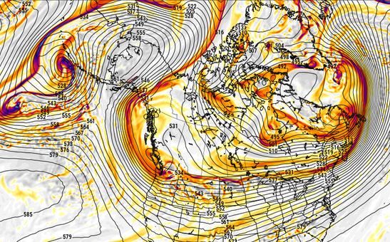
-
December 2025 regional war/obs/disco thread
Typhoon Tip replied to Torch Tiger's topic in New England
12z Euro's Currier&Ives -
December 2025 regional war/obs/disco thread
Typhoon Tip replied to Torch Tiger's topic in New England
crippling ice storm -
December 2025 regional war/obs/disco thread
Typhoon Tip replied to Torch Tiger's topic in New England
yeah.. I've often mused that, 'hey man, I was raised in the Feminati' when seeking defense in discussions with militant lesbians -
December 2025 regional war/obs/disco thread
Typhoon Tip replied to Torch Tiger's topic in New England
Haha.... right. For me, it's what I call "non-representative cold" that's annoying. This is non-representative when it's just cold. Yeah, one gets sick of that. And it actually doesn't take long to get to that opinion. Like, a one failure to represent and up! I'm ready for February's annual 10th exit of the solar minimum and hearing about Ray's canonical warm bum on his car seat. heh. just kidding Cold is a necessary evil if we want to have interesting winter Meteorology though. So long as the latter is a part of the cold, no issues. -
December 2025 regional war/obs/disco thread
Typhoon Tip replied to Torch Tiger's topic in New England
yo yeah not sure yet. It may be a last minute thing. I have a huge family. Not sure if I've ever exposed this but I have 9 sisters and they all have demands of one another's time - including their sole bro. Since, truth be told, there are only 7 still living, that's like a political urgency to be ... anyway, there's a thing tomorrow - not sure how long. There's some conflict there. -
December 2025 regional war/obs/disco thread
Typhoon Tip replied to Torch Tiger's topic in New England
You know i'm not part of this conversation but I've always felt that 'conditions' aspect is over applied. We used to play in the "Waltham League" back in my late 20s and early 30s. Great era of life really. Despite all protestations of the times, looking back, I'd love to go back - maybe even do some things differently. Anyway, we met up around 9 or 10am on Sunday mornings before the Patriots game - mind you, this was when the dynasty was just getting going. Imagine that? 20 guys supposedly doing flag football; eventually just ended up being so aggressive that guys took hits once in a while; all the while, visions and fantasies of being somehow a part of said dynasty. Ha. It was a great time. Then afterwards, we haul our steaming bodies to the Mad Raven on Rt 20, for Guinness and IPAs ... wings and Patriot's victories. Oh where was I going ... so we were literally steaming. There were a couple of mornings where it couldn't have been more than 20F, over a few inches of trampled packed snow on the field, and by 3rd down of the opening drive both sides were down to t-shirts. Just going by experience, football is a hot f'n sport man. Now... okay, if it's -10 F like the Ice Bowl game or whatever, sure. But if's just a normal climo winter's day, and their playin' it's hard for me to imagine cold being much of a factor. -
December 2025 regional war/obs/disco thread
Typhoon Tip replied to Torch Tiger's topic in New England
The 0z GFS was similar in principle. From this range ...of course, neither has much substantive value. Have to wait it out on details and dailies. However, there is a new character that's shown up to the plot. The EPS made a move overnight that may offer nostalgia's salvation for the the Holiday week. It's very new, so we'll have to see if this continues. It's the North Atlantic Oscillation. The thing is, the actual index numbers from the GEPs and GEFs do show a slight correction down .. hmm. The EPS was a bit more representative, though. It's very all or nothing in that last 10 days of the month. If we end up on the N side of the ambient polar boundary, than record warm still - likely - happens in the conus, it just won't make it in here...where we will be at risk for something like a 00z GEFs and/or Skynet type of stalled boundary with mixy shit running along. So big contrasts along the boundary... A west-limb -NAO expression would limit warmth expansion over the eastern continent no farther than 40N. Again, it's a fledgling signal... But, as we had that -NAO about 6 weeks ago, when it decayed ... we relayed into the -EPO mode. The NAO's been in hiatus since. The EPO now failing to refit ( while the -WPO continues to fester ..different story - ), and with the PNA going negative, the longer term correlation on -PNA is actually the -NAO. So there's climate-wise support for NAO to reassert. These index correlations are not 1::1 of course; they can verify in an aberrant/unexpected state. Something to keep an eye on if your the winter/Holiday symbolism types. It's at least based on a real observation from the tools themselves. Yesterday at this time, this observation could not be made; I posted direly, accordingly... but, sometimes, that's all that is needed LOL -
December 2025 regional war/obs/disco thread
Typhoon Tip replied to Torch Tiger's topic in New England
'Good Heavens! are you guys still trying to win?' -
December 2025 regional war/obs/disco thread
Typhoon Tip replied to Torch Tiger's topic in New England
This GFS run is a riot major coastal and a foot for interior, then 590 hgts 5 days later off the EC. That's a spring antic man. Typical on an extended range March chart -
December 2025 regional war/obs/disco thread
Typhoon Tip replied to Torch Tiger's topic in New England
Still waiting on the Euro myself -
December 2025 regional war/obs/disco thread
Typhoon Tip replied to Torch Tiger's topic in New England
Accounting for the typical NAM biases at this range this is largely a non-event. I'm waiting on the Euro but with all the pieces firmly now inside the denser/more physically realized sounding inputs, this hasn't trended favorable. Probably was time to move on earlier but in deference to desperation ( lol ). Anyway, the next possible notoriety in the pipeline is possible historic warmth during the week of Xmas. I know ... I know, not a notoriety some would incline to marvel. But, it is what it is. Unfortunately for the winter/snow/Currier&Ives settings enthusiasts, the following is more coherent than not. The indexes signal a warm period. This is suggested numerically, but is definitely than supported when noting the idiosyncrasies of the spatial layouts coming from the different clusters that has been emerging over the last couple of day's worth of cycles They've all been incrementally retrograding the -WPO ridge W, across the N. Pac. Meanwhile stopping/signaling any emerging positive non-hydrostatitc hgt anomalies amid the EPO domain region. Meanwhile, the PNA slipping negative through Jan 1. So with +EPO/-PNA, this does correlate well with a Pac NW River-type circulation mode, which then teleconnects downstream with the SE ridge response. This is uneasy, as we've been seeing this feature there - albeit suppress and compressed - despite the current cold pattern. When that compression relaxes in lieu of the above, that sort of implies a carte blanche in latitude with the SE aspect. I wouldn't get to blown away by amplitude for now. Although ... I must admit, I'm fighting the impression that warmth is like .. in a state of always being spring-loaded. When the cold relaxes, go the other way above "Climate anomalies" more frequently than we used to. That's also lurking in there. We'll see -
You'll probably be right ... seasonal prediction's not my thing. I'm just basing that on part hunch, part knowledge related to -ENSOs of this bandwidth. But I'm also of the mind that ENSO is often too heavily weighted in the game. NP-GL-NE are modulated by polar index modes; I just see this year as having polar field abandonment issues later on. That leaves the continent S of ~45N vulnerable to early warmth. I'm thinking along the lines of how big spring warmth has a correlation to preceding Ninas. Not really the type of correlation the average engagement in here might accidentally stumble upon, much less ever pursue LOL. So experimental -
-
Wasn't a formal forecast but it was the right idea. Once the front winter onset terminates to inevitable warmup (whenever that happens ...) the question will become, does the aft half get back to business. My present thinking is still leaning on reduced hours and a lot of unscheduled signs flipped to 'Sorry we're closed' (lol). I would never suspend January. Not yet anyway (sniff). But sputtering into an early spring...? why not. One of these flower Februaries.
-
December 2025 regional war/obs/disco thread
Typhoon Tip replied to Torch Tiger's topic in New England
GFS won ? -
December 2025 regional war/obs/disco thread
Typhoon Tip replied to Torch Tiger's topic in New England
I could see a NAM low developing and maybe clipping southern southeastern zones as it’s blowing up going out - NW bias notwithstanding. But then we fill back in with radar with inverted trough of some sort because… that’s a very deep polar core coming down at mid/upper levels that’s gonna generate a ton of instability, even in this cold air -
December 2025 regional war/obs/disco thread
Typhoon Tip replied to Torch Tiger's topic in New England
Tough situation because the euro and the nam are not impossible while on the other hand, the background circumstantial synoptics really support the GFS solution. I’m leaning away from previous GFS total flat solutions. Whole system is kind of weak though so should a compromise take place that is still not good enough. In order to be more than just snow in the air we probably would need a NAM solution to be more correct out right -
December 2025 regional war/obs/disco thread
Typhoon Tip replied to Torch Tiger's topic in New England
I’m leery of NAM’s fairly dependable NW bias with cyclogen near east coastal ….however that’s tendency. There are circumstances when that can be a good thing - particularly when there’s very intense llv thermal gradient along a steep frontal slope …elevating into increasing diffluence above. Dec 2005 is an example of that and superior resolution winning the model debate. Not an analog per se… But the higher resolved resolution might find the low level instability axis closer to that gradient, helping to generate intense UVM in that vicinity under which the cyclone generates -
December 2025 regional war/obs/disco thread
Typhoon Tip replied to Torch Tiger's topic in New England
that is an amped solution no doubt -
December 2025 regional war/obs/disco thread
Typhoon Tip replied to Torch Tiger's topic in New England
as we close in on 14th ... just be leery of the NAM NW bias/amplitude issues beyond 36 hours -
Occasional Thoughts on Climate Change
Typhoon Tip replied to donsutherland1's topic in Climate Change
https://phys.org/news/2025-12-hypertropical-climate-emerging-amazon-exposing.html -
December 2025 regional war/obs/disco thread
Typhoon Tip replied to Torch Tiger's topic in New England
Fantasy range appears headed for the same CC apocalypse lol


