Typhoon Tip
-
Posts
43,439 -
Joined
-
Last visited
Content Type
Profiles
Blogs
Forums
American Weather
Media Demo
Store
Gallery
Everything posted by Typhoon Tip
-
So this thing produced more rain than that "coastal" last week ?
-
That 'meso low' leaving the Harbor looks like it was buckin' for a tropical designation ...
-
that umbrella should be a cosmic d-do ... There is no consoling in an engagement that really has less to do with weather. Oh, there is some weather in there, but it's vastly more so a weather-related-emotionally-guided on-line support group, and always has been heh The only way to cure that is to therapeutically uncan the history that left voids... This inCREdibly healthy alternative instead recreates their fear of abandonment issues. 'Daddy's coming home' 'Mummy really loves you ... which, neither turned out true. Or an old g-f of b-f ... some systemic abuse. Pick one's proof of no god. They couldn't control the outcome back whence it wired their unresolved psyches. The utterly untamable wind is just like the daddy or mummy, love or circumstance that demoed zero regard for them. Weather blogging by Dr Joyce Brothers
-
Rad suggests there's a N to NNW motion... Most areas out that way are getting pelted E of ~ Tolland HFD line from the stuff that came up over eastern LI... NYC appears to be warm sectoring or is about to
-
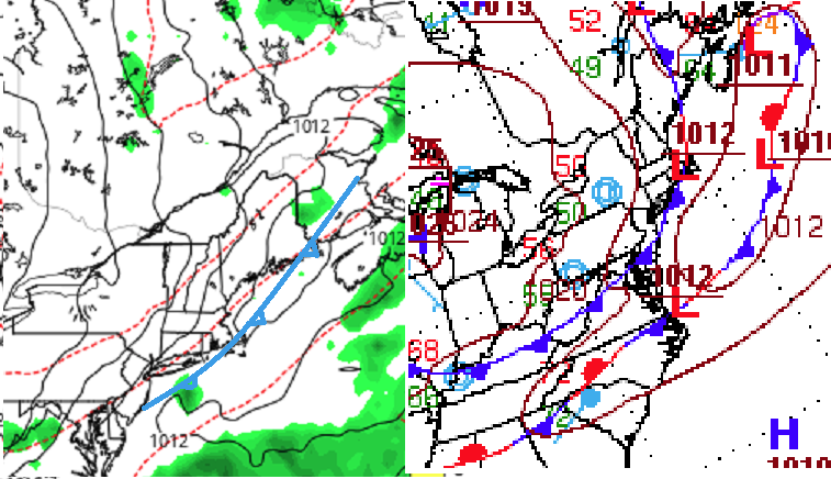
Warm frontal position has been redrawn since the 13:31 update. WPC has it slammed up against the S. Shore ..pretty much cookie cuttering the coast-line. Along with it, the lift region over the elevate frontal slope has realigned through CT-RI into SE Ma.... In short, the region may see more prolific downpours rain types than just a strata form - this morning I was speculating that may result, but seeing as the synoptics continue to evolve toward moving the w-front actively N, it's no surprise we see heavier rad returns in said areas. Tomorrow still looks air mass clappy
-
I almost wonder if the modest convection signal percolating over the interior for Tuesday ( tomorrow) afternoon might be more successful. This stuff this morning is pretty clearly over-running/elevated convection as the weak environmental 0-6km flow runs over that warm boundary extending seaward of the lower Jersey coast. As it ignites along that sloped elevation (frontal interface), the elements/cells then lift N/NNW tantalizingly but spreads out and becomes more diffuse because they're raining from higher elevation as they come. Fuzzier by the time they get toward the Pike. That's pretty classic overrunning behavior - use to be called "strata form rains" where the cellular look becomes smeared.. However, the total manifold of this thing is similar to that ordeal last week that almost failed to develop a coastal at all - just enhanced NE winds for a day... In both scenarios, the governing kinematics are weak. I'm not sure this has the nuts to 'fill in'. Looks like fractured coverage with gaps ...I think that's what the Euro's been trying to signal. Frankly, the NAM ... despite it's overall synoptic uselessness, is having trouble tilling .5" on the FOUS grid while being inside of 24 hours... Hate to say, not a good sign. Tomorrow, the warm boundary appears to get to about ...I dunno may SE VT over to PSM, but is losing identity as it does. But that's when we may destablize. The sun more able to penetrate ...heating and bubbling towers.
-
A buddy at mine in Auburn was under that slow moving street cleaner yesterday. His station recorded 1.61"
-
Heh...18z NAM is in with a stunning drought correcting .12" at Logan... but at least it's got close to .6" at Albany -hey
-
"...Only white man would be so careless as to make smoke in the open for everyone to see "
-
Yeah it’s been known and discussed for quite some time going back decades actually. The idea is that for whatever reason there’s some 30 year return window for that kind of behavior. I’m not sure if anyone et al has formally researched any sort of correlation versus causality but looking at those spreads it does kind of suggests that there is some sort of periodicity involved. Faux platterns can emerge in nature sometimes and given longer periods of times prove to be random, as well.
-
Lance Bosart ( UofAlbany) gave a presentation which attempted to link active autumn hurricane years to stronger Greenland polar vortex tendencies (+NAO) during immediately ensuing winters. I saw the presentation... I want to say it was given at the SNE storm conference back in the aughts, but it may predate that. The AMS/New England one up in NYS back in 1996, but that may have been convective focused now that I think about it. Bosart's (et el) was based both in part statistically, and a-priori/experience ... ( which I guess really implies 'responsibly anecdotal' in the latter sense) The basic theoretical framework is that re-curving cyclones feed latent heat ...reinforcing the l-wave spatial-temporal distribution, in which the PV coherency emerges - It makes intuitive sense.. The baroclinic instability would theoretically enhance whenever episodic heat plumes deliver into a region that is right next door to a heat sink AO domain/Ferral easterly circulation manifold at higher latitudes. It's huge potential vorticity ...realized by storm genesis. Therefore, the seasonal leading behavior/proficiency may serve as a means to predict the NAO index modes during ensuing winter. The problem is, when I search the web/archives for any papered work, it's always leading to N Pacific ... But I was there. He talked about the N Atl and the PV there in this context. I can think of counter-point/arguments too... Like, winters are long above 40 N, whereas the Atl TC stops that activity by late October ( typically...), such that it's forcing would surely be washed out by the pummeling maelstrom of Pac loading forcing the N/A pattern - given time. So it may be more useful earlier in seasons. I mean I'm not sure ... just conjecture there. It could also be ( and related to school I happen to agree with) that it is an index reinforcrer, but not a drive.... When the Pacific --> N/A --> +NAO, and the tropics are delivering, that is a constructive interference, and vice versa. He's emeritus at this point, but is lauded as a world-renown theoretical synoptician. I mean this isn't some influencer's opinion. ha.
-
..mm hm.. .and I was wondering to self this morning, if we can get through the next 10 days without realizing one of these GFS buckshot attempts, would this Aug be a candidate for low monthly record?
-
I haven't been in the region over the last week, but ... prior to that, for the longer haul of June thru mid Augu... I don't recall the DPs being very high - thus, not a very "humid" summer. June was cooler than normal ( ...if by relativity but I think it was in the scalar values), and July and so far August are even more so above normal in terms of absolute value. So, the summer as a whole is likely to end above normal in temperatures - that's easily measured. But there have been a lot of a 95 days with DP settling down to 58s. It's tough to run aridity in the soils and then celebrate drought histrionics both concurrently within a DP rich environment. Just a refresher course ... DP is a thermodynamic temperature intrinsic with the presence of water. Drought is the absence of that particular component. So, ... conceptually a humid summer is not supported; pretty sure we'll find the DPs have not been anomalously high as well - but that's not a declaration. Just a guess
-
Doesn't look like ^ is working out as well as initially it looked. I don't know were the DPs scheduled to crash this hard mid day? BED sunk from 66 to 53 ... impressive.
-
With additional DP moving into the region the temperatures may be a tick or two traded downward over yesterday's highs.
-
What we're seeing in the guidance 'canvas' for this latter August has been stable in the guidance ... dating back some 2 weeks really. The projection back then looked as though more pedestrian heat would fashion the return dress... basically to finish out the summer. The snarks amongst us would diminish the notion in a breeze of 'well that's the climate timing anyway' typology but no. It's going to be above normal - most likely - during. And that still seems to be the case. So the big heat would come to an end. Since ..the 'coastal' ( if we wanna call it that ) did emerge in the interim, as an additional distraction. Frankly, this was really more of large sprawling, more modest +PP anomaly that enveloped over S. Canada. It orchestrated a broadly oriented E flow across really everywhere below the 50th parallel ... Kind of an interesting way to move from an en masse westerly-sourced heat signal, like a planetary correction. But once that set up, it instantiated a basal baroclinically unstable environment, along the OV to NE axis underneath... What the coastal lacked amid that region was sufficiently strong enough mechanics to really work within that favorable environment. Also, cold air. Moving cold air from E to W, N of warm air, along better defined boundaries are key circumstances. Nonetheless, enough cooling onshore flow did augment this interim 'mild-down' to push that correction vibe further. Really could have used the rain ... though. I'm not personally too concerned over the 3 month drying just yet. We need to press this through the autumn, then successfully strand the region in a dearth winter before I do - deeper hydro is minimally impacted - unless that's suddenly changed in the last 96 hours... Am aware we are in the top 5 ( as of last check ) driest JJA.
-
yeah ..cuz ya can't steal something that doesn't exist ...
-
Perfect weather here in Mi. 80/50 Kinda surprised that things even gonna affect you guys. The flow is so weak and only vaguely mechanically strong enough to guide a coastal system along. Probably why it’s been handled so atrociously … it’s on the edge of even being able to exist. Almost has a tropical look too
-
82/52 ... sun is searing hot tho -
-
Last night's Vegas downpour was excessively localized though ...there wasn't anything within 70 + miles of that solo cell as it went precisely over the city ...pretty much the same size as the city limits. Talk about dumb f'n luck -
-
This run has more actual short wave mechanics loading into the trough basin (albeit subtle) - something we hadn't seen. It's like the previous runs were opening up a deeper geopotential nadir, not based on that requirement. It's been the primary reason for my backing off the idea. That, and the fact that the GFS has been having to correct just about everything it ever sees beyond D5's, to something less percentage-wise in amplitude coming into nearer terms, since about 2014 () It's intriguing as a subtle but important difference. We'll see what the ens of the EPS and GEFies do
-
It's a toy, that's why. They just haven't had a chance to play with it.
-
You and me are on the opposite sides of the druthers ... sort of. I prefer a front loaded winter. The best example I have ever experienced was 1995, with close 2nd place perhaps 2008 then again 2010.. Those years had snow pack through all of December - check that on the latter two... may have been close. But definitely that was so 1995. So, that's going back almost 30 years at this point. It's hard to do the earlier, ..as that sample size alone less than delicately points out. So my expectations are pretty low any given year that I'll get what I want. 1995 I was attending college at UML, which is situated in the Merrimack Valley - in fact, the campuses total region straddles the river as it cuts through the N side of Lowell. It's probably really more of a southern-SE NH climate characteristic. But, that autumn started featuring large diurnal spreads by mid October. What's funny is this seems to conflict with warm spell memories of others that month, but it sticks out to me how many deep frosty mornings we had there after the first week of October. By late month.... there was ice on the shade side of the Pawtucket hydro- viaduct. The canal was built of granite slabs, tightly fitted...each probably 4 tons. The fascia stoop some 50 foot above the river basin by the time it hits the defunct hydro electric dam. They still use it to control flow rates...whatever - may not have that entirely right but that's what I always thought. Anyway, the water pressure squeezes through the seams between the slabs at trickle rates... It's normal. But it's kind of like those seeps you see along highways escarpment where the granite hillside were cut through to lay the road? Those rivulets were freezing by the 20th, and though the afternoons recovered to a crispy mid or upper 40s, by then the sun is so sloped that the N wall of the viaduct is in eternal cold shade, preserving those fragile ice features in the still cool air. Yellows and saffron hued trees dappling the hillsides gave homages to a world still worth being in. Jesus I distinctly remember that imagery, and thinking it must be early in the year to see that. I think that autumn was very gradient though. Like CT was near 60 on those days, and that may be why-for the varying anecdotal accounting. But, by early November ...it was clear, this was an unusual mid to late autumn setting up. I recall the recently decease Mish Michaels had stopped by the UML Weather Lab to tour the facility. She would later briefly tenure a professorship to teach intro to media... We didn't have that access as Met students prior to that; that operation up there was like Navier-Stokes jump off the chalk board and took on a daily form, and we lived each derivative. Where the f am I going... Oh yeah, she and I sidled up to a PC and observed the then, MRF model, churning out coastals on the long range charts in regular periodicity. We were commenting like any little wiener shnitzels would, about how it was plausible because the -NAO this ...and the predominating +PNA while that was happening ...were large scale hemispherically favored ... blah blah-blah blah. Dr Frank Colby rolled his eyes - serving as tour guide - and rolled back into his office while we drooled over the console. We were right. By mid month, there was a solid pack. It was sleety in nature, but plenty of snow. And it was cold! I mean, those first couple of gigs laid cake, but there was arctic cold by mid month and the Merrimack back waters above the dam were actually freezing some 45 days ahead of typical. It was a white Thanks giggedy... another storm months end... We were sitting on a foot of strata pack type from Acton to the Lowell... Not sure about CT-RI, but I suspect by then the polar suppression had engulfed all the way down. December? Forget it... man.. .I recall climbing over curb-side snow banks to access pubs down off Beacon street, with 9 F cold and vocal steam vapors falling instead of rising type blue nuts cold. By then I think there was 18" of glacier not going anywhere. Another storm 24'ed the pack into Xmas ...something like that...Then, we were biding time while the Megalopolis Blizzard '96 was emerging in the extendeds, with no means to modify the ginormous scale in mass of that eastern Canada and the NE U.S. cold - which loaded the region as the solar min was sweeping over the hemisphere ... That was one that you knew with exceptional early long lead confidence, it was either all snow, or no snow due to a PD deal... But there was no way it could like physically rain...LOL. And it didn't as we all know that are old enough to remember that monster. We had 35" of snow on the level a week after the Meg blitz...because there was another coastal that laid down an unthinkable new 8-12" It was a wetter snow ... The air smelled like rain while it was snowing. Perhaps an homage of what would transpire a week later... It was big deal because roofs wee starting to fail from weight. Then, the thaws.... removed it all!
-
That's only happening in a complete shut down overcast over saturated RH rains, which was the 00z layout... Again, I don't like the idea. The 06z is more keeping with trends, trends that fit climo and other synoptic reasoning related to persistence, and separately... model performance when relaying late mid range into mid ..shorter visions. We'll see. It's sort of an interesting test in an otherwise dearth of anything in this hobby that requires much attention - in fact, ...this aspect has already been given a lot more than it needs in a vacuum, but we have the hydro concerns drawing the focus.
-
Fwiw WPC's recent sfc analysis suggests the front is too close to have effectively scoured your air mass just yet, and quasi stationary with a bump low. It aligns roughly up down shores over eastern Ma/Me...and even back here some 40 mi west of that idea ... that all means the momentum wasn't likely enough to completely cleanse just yet. That would be my guess... Here is the Euro's most recent run and it lines up the position ~ 9z within acceptable error.