

Typhoon Tip
-
Posts
44,235 -
Joined
-
Last visited
Content Type
Profiles
Blogs
Forums
American Weather
Media Demo
Store
Gallery
Everything posted by Typhoon Tip
-
Y'all realize that's the day 15 and 16 GEFs there? ... either way, that's likely over doing the AO domain. There can be a descent in latitude with SPV, achieving extreme geopotential depths, without that layout over the arc. The Euro's chance for a mix event down to Rt 2 has legs imho ( 20th-ish). The Miller A should be watched on the 22nd
-
It doesn’t carry a lot of deterministic value but for example… the GFS operational version out there between the 23rd and 26th is a perfect example of what we’re talking about wrt negative EPO type system profile. That’s a decent front end dump of snow followed by glazing scenario for interior Massachusetts with ease on that solution even though the 500 mb doesnt look anything like it would drive that.
-
I am noticing propensity in the GFS toward a -EPO rendition of pattern modulation... That version does slow the penetration E across the continent with distribution of cyclone track and cold, during the 20 to 26 time frame. The EPS cluster is more +PNA ...getting there quicker, with less obvious positive g-hgt over the Alaska sector. There is room for either version to manifest. Just a word of advice as we tick days closer to a possible if not likely, winter recovering mode for mid latitude continent. Having said that... the EPS might offer hope for winter enthusiasts, sooner, with more commitment to EC. But the GFS version could also perform in overrunning "Minnesota squeeze" type mixy results. I suspect the operational GFS is too extreme, either way. How much or how little -
-
Mm... the post was not to intended to aver any actionable course correction - just in case You have to specific/qualify a post or there's a tendency to interpret. I figure you know that... But, I was offering a suggestion (plausible) to offer some insight as to why-for some tendencies we are seeing in recent guidance evolution.
-
no kidding ...? LOL
-
A GFS flavor would likely result in what Brook's is screaming re the overrunning type messy winter storm structures. The EPS ... what does the UKMET family look like? I bet that might be interesting - but it may not go out far enough? The UKMET loves to curl the flow early, so if it is somehow avoiding the SW tuckies, heh.
-
Nope - ... not allowed. either George runs the model from his basement ... or bust.
-
exactly ... And I don't have a problem with it doing that per se. I find it interesting that the GFS wants to force a pattern change toward that variant, where the other's in the playground want the +PNA/PNAP version
-
It bothers me that the last several cycles of the GFS operational version have/are just about 180 degrees out of sync with the EPS in the 240+ time range, wrt to the 500 mb isohypses layout. It doesn't bother me for deterministic forecasting - per se... But I do feel pretty strongly that a pattern change ...if indeed that takes place, would likely already be exerting between D6 and 10. SO what? is the GFS trying to avoid even changing that pattern?
-
Definitely more of "burst" appeal to this snow at the moment. Still just 28, but uniform mid sized aggregates with vis down to 1/2 mi. Not looking at radar so as to not taint the experience with reminders LOL
-
I've been trying to pay more attention to this model ... get a handle on it's usefulness. It's referenced from time to time in NWS afd's, etc. Can't figure it out. It had a backed solution like this 3 days ago... when none other did. Now, the others do, and it won't - okay. Still new to me with this tool though. Actually ..as an afterthought, I do recall there was other suggestions from guidance et al for a second wave/bulging west, but it wasn't done this way. Interesting. I remember posting that I don't typically like the bulge back west scenario in modeling at the time. But this is different in that the low is cut off more fully and waits 24 hours before retro -
-
It's for symbolism perhaps ...but considering where this winter has been at least out side my doors here in Ayer, seeing it snowing at 28 F is a rare, precious come-by. Well formed small to mid sized dry aggregates, with a couple of degrees to spare no less.
-
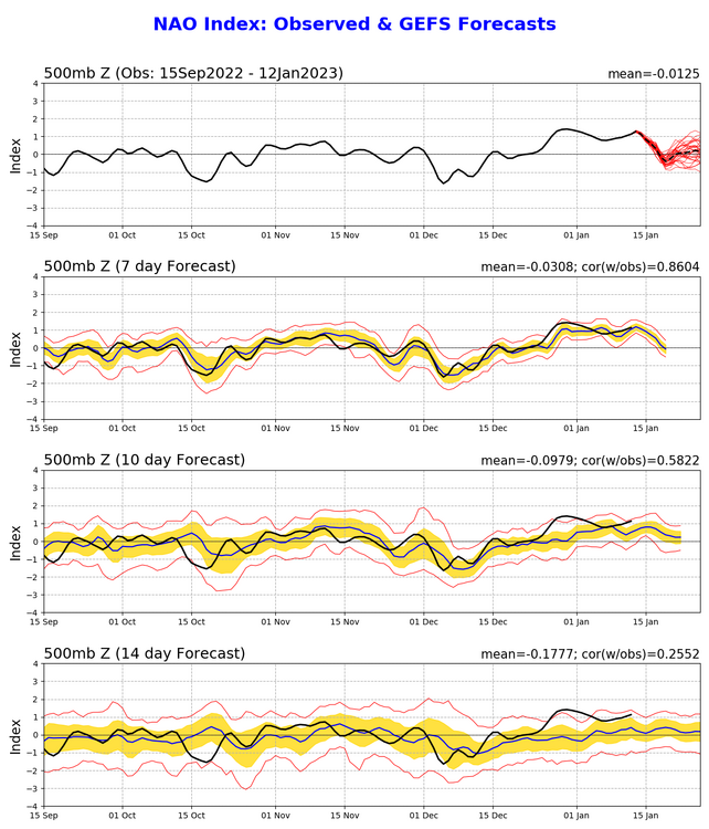
Correct, it is important when evaluating to keep in mind that the magnitude scalar value of total change, is less important than the occurrence change blah blah But this weekend’s more recent emergence in the runs may not be triggered by that NAO … it’s really more a situation of getting caught by it. The ocean cyclone’s set into motion first … then the NAO dumps SDs, and in terms of what that means to the pattern … the.cyclone gets a retrograde momentum applied to it - That appears to be the larger scaled super synopsis. Not a major event. Probably bands rotating in with wet snow cat paws on the Cape with a stripe farther W maybe BOS to PVD and points E.
-
Re the weekend folks should be aware of this indirect /possible factorization
-
Walt, it's a personal view ...but I suspect it ...and the 19th/20th ..et al, trending very recently, may be transitively related to the pattern change. Noting the deep layer tropospheric circulation mode over much of central and northern Asia is changing from a westerly predominating flow to a north, in as little as 48 hours! That sends a robust signal down stream and resets the dial across the Pac... Not sure why the GFS has been resisting, but the 0z GEF mean resumed... I don't believe a progressive/native GFS bias is well suited for where the hemisphere is heading post the 20th... so that's negotiable. But the GGEM and Euro are already pressing a latitude ridge signal into western continent by the end of their runs ... The ocean storm in the foreground may be a coincidence, but it actually fits where the hemisphere will be about a week later - fascinating.
-
There is some chance this 19th/20th feature suppresses S-E in time. The advertised pattern change nearing and especially post the 20th, may be indirectly involved in why. Noticing in both the GGEM and Euro solutions...riding is approaching the western continent and coming on board over the end frames of the 00z run. That may influence the aspects already over the eastern continent. May be evidenced in the NAO telecon, which is slumping through the period, ... moving a scalar mode of ~+1SD toward neutral. While not a phase reversal, I suspect that is responding to the 'crunch' of the wave spacing across N/A ( transitively causing the NAO domain heights to begin to rise 2ndary/ or non-linear wave response if we wanna get into a popsicle headache). But that backs us into a plausibility for less Lakes cutter. The thing is... the EPS and GEPs are not interested - so that puts this into a low confidence, albeit still non-zero chance for success. Sometimes, however, the souped up main operational versions begin to converge on an idea and through rarer, the less refined dispersed solutions then gather in the other direction. I wouldn't bother to mention this post but...we in fact have modeled hemispheric en mass circulation modulation taking place that offers feasibility. So we'll see
-
Sloppy analysis ... I have not honesty been paying much attention to today's affairs. But just cursory eval against synoptic awareness, a nice little warm advection snow burst. Radar filling in rather quickly over CT and western MA over the last hour..
-
Noting the NAO slump ... not really a mode change, but it is neutralizing from +1 SD - may be the other side of the same coin with the PNAP changes forcing the NAO domain down. Either way, that might be a sensitivity indicator/suppression tendencies correcting in small but crucial amount, given time.
-
Also, did anyone notice SE zones could be clipped by ocean storm or OES enhances between D4 and 5?
-
There is a chance this could evolve sooner with a risk insert... While the 19th/20th may not directly be embedded in the extended range pattern change expectation, but could transitively be influenced ( that outta sound confusing!). The GGEM and Euro ideas surrounding +PP building over QUE and confluence in that area, might be getting enhanced by the ridge surging into western N/A - this latter aspect is the leading edge of the changes ... so, there may be some causality there. Anyway, this is not unheralded, these solutions with cold available at least to CNE and possibly to the Pike in Mass ( if not colder?). I thought yesterday that the bigger polar high idea the GFS had the previous day ...might not be baseless. And it still isn't. There's time ...
-
You all need another “”fix” to rely upon in times like these other than these models lol
-
yeah ..this totally happens all the time ....
-
The GFS offers yet a third option to the EPS vs the GEFS ... No pattern at all - This run has a 9.4 wave pattern over the Hemisphere at D11.5. Garbage solution. It's clearly having trouble on the interface between patterns out there. I'd definitely sans any operational GFS runs outside of 7 or so days, even more so than the normal for extended shenanigans, until NCEP figures out the physics of non-linear wave mechanics...
-
It’s really not a bad day to look frankly but it may turn active sooner
-
That first one kind of reminds me of 9394


