

Typhoon Tip
-
Posts
43,417 -
Joined
-
Last visited
Content Type
Profiles
Blogs
Forums
American Weather
Media Demo
Store
Gallery
Everything posted by Typhoon Tip
-
Yeeeah, the aspects of that list I provided are seasonal, too, not just sub-seasonal scaled indexes. We're really dealing with ambrosia of multi-dimensional winter killers, frankly. From the empirical calculated EOFs, to the super synoptic "intangibles" and back. It's like a meteverse coexisting and competing for reality. Lol. Anyway, like I said, I've been biding time. In deference to having Canada loaded up with cold, that's really more like agreeing on the hybrid nature of the AO. One has to be careful with any index application, because ( like in this case) this +AO may be idiosyncratic in the way it is modeled/verifies ( spatial layout ) way out there ... +AO can result a warm Eurasia and N Pac, at the expense of a colder N/A ... Just like some -AOs can establish conveyors elsewhere and put N/A on a warm island. It's not always evenly distributed...etc. I mean the correlations are not 1::1 Unfortunately for me, however, I find that to be the weaker signal, and of lower reliance, out of all that avails to the discussion. Nothing extraordinary in saying that - any signal that far out would be, I know.
-
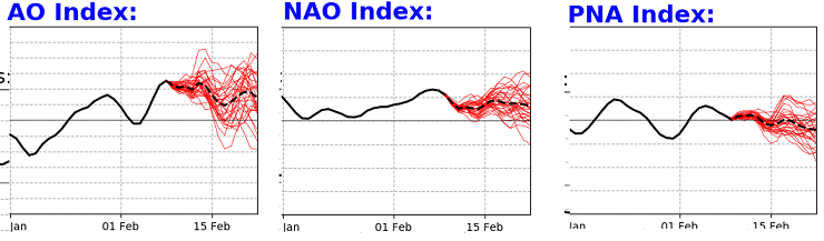
Pretty sure most know my position on matters by now ... but whatever. With this very veracious litany of indicators actually existing and present in reality: +AO/+NAO/-PNA ... ROBUST MJO in phase 3-6 on going and ( probably ) just not as of yet registering a forcing signature (but it may be on the way) ... La Nina climo/springs ... Recent years with these February 'warm bursting' synoptics ... appearing to be independent of ENSO this or polar field that ... and WTF, may as well toss in climate change leaning on everything far more undeniably than the consortium cares to admit ... That looks warm. I just keep waiting for the other shoe to fall, and after a relentless tug of war ...finally, a series of model runs offer up the movie that really should have been premiered already by now: staring some kind of turbo ridge from Hades. I have been biding time out of deference to the Euro and GGEM and GFS with these huge resorvoirs of cold lurking across the Canadian shield. They are bleeding enough of that to roughly 45 lat that we're ending up with this potent ambient hydrostatic gradient ( that looks like March frankly, but even more intense). All that is doing, though, is making the gradient so excessive that these S/W are intrinsically embedded in an utterly hostile velocity shear fest. The Lakes cutter persistence has solid "immovable" fit, too, because that litany of warm cues above may just be like two elephants leaning on each other, and their ass cheek touch along a PHX to DET line. It's just locked in that persistence by two overwhelmingly titanic forces ... (transient -EPOs are the culprit on the other side). I would not say it is likely, but there is a something better than a mere non-zero possibility ...we've seen our last snow this year. I mean I'd put the odds of that at the lower end, but > than most years or the 300 years (irrelevant?) climatological signal.
-
It's also greater SD in the 850 mb level, too ( for those days...) than previous runs. One aspect of Wed/Thur this week re the Euro ( talking to the general audience), it's improved its 2-meter temperature outlook ~ 2 F per cycle going back two days. Perhaps not linear increase, but on average... Synoptically, Wednesday enters contention for 'nape appeal' at this rate, too. It's got a deep layer WSW flow already established, with 850s to +5 by 21z the afternoon. There's likely to be gunk skies around because there's a dying Lakes cutter that's "denting" the field with modest cyclonic curvature ... as it coughs by NW. But if the clouds end up lower in coverage and the winds are light, both possibilities ..., we'll be near 60 despite the 54 MOS/machine and or 2-meter coverage. Thursday depends on sun again... But, the RH at standard metric sigmas are all < 55% ( 700, 500, 300 mbs), so that's an indication there's plenty of that mid day. This is true on the GFS, too. The Euro has also been elevating the 850s on that day, now nicking +10 C by 21 z. Again with deep layer WSW ...by then, very well mixed and likely a taller BL. That's a high temperature of 72 ... I don't believe the 2-meters are representative of a well mixed ( or enough) in any model on Wed or Thu afternoons. And the MEX is definitely too cool at this time of year and range. Given the very warm looking telecon spread as having not really yet fully realized in the deterministic solution sets as of late, ...the subtext to all this is that the correction vector is warmer actually. I'm a just tedious enough about this weather fascination to test these early warm up days, so tfwiw -
-
Probably the same as the number pumps in a Turkish prison
-
Well … that 18Z GFS was certainly no fun for winter enthusiasts. Seriously that aside tho, I’m starting have doubts in anything at all taking place in that regard the rest of the way.
-
You probably know this already so not directed at you per se, but that chart is often misconstrued as meaning that, "warm" or "cool" that's not what that product is indicating. it's there to state there is a 40, 50 ... 70, 90% chance that a region will be above normal, or below normal. It doesn't give any scalar indication of that extreme. It could be .1F above normal in the magenta region, and that's a huge score for that outlook - in other words... That helps in a situation like this... because, that SE ridge is there but until these competing signals give up on the N/stream compression aspect, that above normal is likely to be tainted down by periodic clouds and 'dirty warm sector' ... I'm not trying to bun myself here - what I'm saying is the proper use of that product. If the N/stream backs off... than the "type" of warm departures may feature more in the way of what we associate psychobabbledee-doo to red hues: unabated expansion of the ridge allowing for larger diurnals - typical early spring dry warm burst
-
heh... certainly not around day 10 of that Euro run.
-
The problem with "plausibility" in argument construction is in the definition of plausibility, itself - it seems likely to be true, however "seems" seldom is in any reality that they are used to describe. All of what is typically used to refute climate change may even be clever, when not eye-rolling obviously divisive and/or evasive. However, ...and often escaping the arguer's attention, those uses do nothing to abase or remove a key, fundamental physics constraint: Elevating green house gasses always stores more heat. C02 ( as well as catalogue of other NOX and gas types ..) are higher than 100 years ago, they've got no case. If C02 is higher in point-time B, than it was at point-time A, the space in which it occupies became greater in capacity for storing thermal energy. That cannot be controverted.
-
Sort of ..yeah. The total Sonoran heat release model is - to me ... because I'm a staggering dork - fascinating synoptically. What actually happens is, it is led off by a period of +PNAP. Not necessarily a "+PNA" - there is an important distinction between the two. The +PNA involves the total local hemispheric manifold/circulation mode, from basically the Date Line across N/A. I think the exact coordinates can be found ..etc. But when we say PNAP, we refer to the Perennial North American Pattern. That pattern is described by a modest 'bulge' in the basal flow characteristics, in the heights over western N/A, due to the prevailing westerly flow incurring upon the western N/A mountain cordillera. The flow rises over it, and then the C-force causes it to turn polarward. A standing ridge becomes discernible over the perennial mean. The flow then tapers back S as it's leaving eastern N/A. That distinction offers an opportunity to distinguish 'event machinery' - PNA tied to total atmospheric modes/modality, whereas + OR - PNAP can move with that, or just be transitively influenced ... Similar to the NAO in that respect. The NAO demos more stochastic observation of its mode states because these stem wound maritime bombs occasionally sequence through that domain space ... setting off quickly recovering negative and positive index values. They may not represent the longer term return mode, either... - gets into headaches. So anyway, with the "SHR" ... the modest +PNAP "caps" heat and it cooks over couple of few days... really loading an H850 level kinetically charged layer.. This layer is pretty evident on soundings; often associated with an EML type profiles... but the two can exists independently.. So what happens is, the +PNAP gets perturbed and tries to go negative - if not succeeding. This dislodges said plume of KC8 air ... Given the amount of -PNAP determines the arc in which the KC8 ejection moves down stream... Sometimes it's south through the TV ...Other times it takes the N route - "Hot Saturday"/ Aug '75 was an ejected plume that got caught up and rattled around the N route and came down from the NW. That's why our hottest summer events come from a W or W/NW direction. That whole long-ass sermon above may or may not have preceded the 2017, 2018, 2020 events...etc. It is likely too early in the year to cook up the KC8 layer ..etc. But, we can certainly get a very amplified -PNAP and/or -PNA, that pulls air out of Tx ( for example ...) - 'quasi' creates a weak variation on the same overall theme.
-
It's sooo close to being a legit 'heat burst' - not that there is any kind of formal definition for what heat burst means. I figure it's gotta feel actually really warm, and not just high 'nape' value - not that there is any kind of formal definition for what nape means ... etc etc. LOL. Seriously though, it's a new kind of phenomenon, the likes of which - for me anyway... - I had never experienced in my ...ah, let's call it 'multi-decades' life span. Anyway, its when any winter month hosts a period of summer temperatures. It's obviously less likely in Dec and Jan. Those two months don't have the advantage of the sun leaving the solar minimum era of the total solar calendar - which is the case in February. That's prooobably a prerequisite for this sort of thing. Although, I've seen it be 74 in Dec... once, back in 1999 I think it was. Even if it's only 12 hours... I figure 75 is the fair distinction. Otherwise it's just global warming in the air - haha. Probably shouldn't refer to these sudden synoptic heat plume events as heat bursts, though, as the name is already designated in the AMS Glossary. Thermodynamics are complex, but outflow from convection causes an explosive rise in temperatures - counter intuitive to the idea of cold outflow. But what happens is, the air goes through extreme/rapid drying, and then is compressed. It's more common where mountain topography vanishes out into a lower planar region - I've heard of heat bursts raising the temperature from 55 to 103 in S. Dakota for example... what the f am I talking about. I just wanted a distinction for the 'special' 2017, 2018, and 2020 type summer flash synoptics. That as a specific characterization separates its self from like yesterdays 'historic' aspects.
-
18z GFS a step closer to a real heat burst. I’d say the 2m T over eastern zones to 65 from this range may actually be a nod to 72s with those synoptic metrics between 18z and evening of the 16th.
-
Apr ‘97
-
Agreed... I've been explaining the same facets in my own unintelligible way all winter. i called the 7/8 RMM boundary the "La Nina firewall" for fun. I'll just add couple of aspects. This year's total circulation manifold, other than that ~ 3 weeks post Xmas when Calif got bombed by a Nino river, has been dominated by a well-coupled identity wrt the basal La Nina. I suspect that persistence/bias only decays at the same rate as the winter smears into spring... leaving us with pretty much a complete end-to-end "MJO futility winter". But, there is are competing aspects in the way the local hemisphere ( Date line to S of Greenland) is being handled in the models. In one sense, the right-side RMM MJO is a positive La Nina interference. Combining that with the warm La Nina, late winter into spring warmth, combined with a PNA that's trying to slip negative, etc. These are passive arguments for an early escape. In the other sense, the N/stream is being very aggressive in the means, from all guidance sources as far as I can tell. It's really as though the N/hem is split into a negative interference between the lower and higher latitudes.
-
Pure opinion influenced by objective residue ... Part of my problem with the popularity/headlining wrt to the 'record breaking' warmth today ...and just the attention that was/is given to it, is my own attitude - admittedly. We've been heat blasted to between 75 and 82 F at least three times in the last five years, during Februaries. So by comparison, today just looks and feels - to me - like more of the same shit we've been dealt all winter - not necessarily more worthy of the coverage. Ha...you know - it seems there are two types of wave mechanics to this weather engagement: those that occur in the atmosphere; those that ripple through crowed noise. Sometimes those are in phase... As far as the near miss coastal... Probably, that is what it will be imho. We'll see. But the NAM has that NW bias issue over the west Atlantic. It tends to turn polarward too aggressively. I've been hammering this for years - I haven't seen any evidence that it's been corrected. This is a situation that is perfect for that model to dabble in that bias - an unaffiliated ( with the westerlies) coughing tumbler left to move through the field from something like beta drift almost entirely... ? It may sprinkle/light rain/inconsequential ping for an hour or two SE of HFD to SE Ma... Just the way these aspects we're experiencing appeal to me this morning..
-
31 here ... 53 in ORH... nice
-
well ...it's going to hurt determinism, certainly... That flow is ridiculously fast. I've opined plenty the tendency for velocity saturation in the hemispheric stream line analysis as a recurring theme spanning multiple winters blah bla-blah bla-blah...but some of these runs are the fastest I've ever seen. It's like the warm vision is succeeding at the same time this new bully N/stream is trying to take over down wind of some kinda of ...weird -EPO that doesn't look like one ... and the end result is S/Ws entering B.C. and leaving coastal Maine in < 2 days... wow Yeah, I'd change the word "sneak" to get wholly gratuitously lucky haha
-
mm I've been pretty vocal myself about not being thrilled at the prospects for over significant icing. I don't mind it if it stops around 2/5ths accretion... that's about the threshold where it starts causing problems. There truly is an aesthetic value when the sun rises in the aftermath to set off the trillion prism effect. It's mesmerizingly beautiful ... Otherwise, if y'all want 2" of rhymed death to 20 tonnes of power line loading per standard length segments ...I'd far rather see that in photographs of a far away land, and extend my condolences. F' that!
-
Yeah, the 44 corpse' in Buffalo certainly can't take any issue with this assessment heh. I know tho - you mean here...
-
The trough in the west could still be a problem... If it plumbs the positive anomaly back east balloons and it boot legs a warm burst. But... the flow being fast overall strikes me as having difficulty believing guidance types that bias toward curving flows out in time...a.k.a. the Euro. ( in an aside, I sometimes feel the Euro's 4-d variable smoothing thing is a bad fit for recent climate which is proving faster and faster velocities in the mid levels... One's correction genius is not as well suited to a flow that inherently/physically restricts curvature because it is too fast) Anyway, that may be why we're seeing cold bleeds and these while storms showing up in the extended.
-
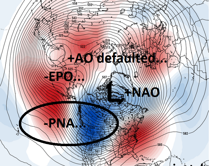
It's an epic battle between these recent deterministic run renditions, vs this ... There's no interpretation - in a vacuum - that supports the operational GFS and Euro longer lead visions - yet they're persisting. We've actually been in this disconnect for awhile in the guidance frame domains. Telecons have parted company... I checked the Euro clusters version of these at WeatherBell and they're essentially the same... But here's the thing... that 'in a vacuum' aspect cloaks the -EPO 'tendency' I put the tendency in quotes because it's a NE Pac ridge node that's displaced from the EPO's canonical domain. It's really a -PNA/+AO(QUASI -EPO) that is causing all the problems. The pattern in the deterministic solutions is utterly responsive to the cold loading off the later mode tendency, and they're physically ending up suppression any other exertion from these other field sources. If we look at this, you can see how a +AO, -PNA, +NAO with a weird variation on -EPO could cause the anti-correlary result to take place...
-
As far as the pattern change scoffing ... It's been pretty clear - to me - all along that there is a tendency to conflate whether a pattern has changed, with whether that pattern has delivered d-drip or whatever it is that is sought from the observed d(pattern). That's improper as a reproach to this - or, ...if you want that to be valid, it has nothing to do with either weather observation and everything to do with some sort of disconnect for anything real. The pattern changed. The sensible result.... no, scratch that. The modeling cinema still did not produce - apparently what really matters to this. There's a phrase available in most languages of the planet, which in spirit means exactly the same aspect about life and times and dealing with what is real... it's called TOUGH SHIT The pattern changed. You're lack of satisfaction for this too 'oft humbling addiction behavior did not. Those are mutually exclusive aspects of reality.
-
Well yeah... in a purely objective sense ( an attribute so richly observed in the regular engagement of this internet social media pastime LOL ...), I have 20" so far this season. That fell from something ... right?
-
wow... yeah Scott. Not only that... the GFS' entire extended range hemisphere has completely vacated any notion of a warm end of month. ( seems the verification of temperatures is always warmer than synoptic signaling in the last 10 years... notwithstanding)
-
Yeah... that thought ( bold ) crossed the mind. I also told 'em a few moments ago not to dismiss the Euro out of hand, too. I'm still objective about this. Fun posts should be taken lightly -
-
mm hm.. but don't cha-guys kinda sorta get a feelin' like this is trying to get us as close as imaginatively possible without ever having it take place? The UKMET solution? sure, of course - that's the bate run. While the weight of all others combined into a consensus that only toys ever closer. Therefore, when the 30" of accumulated sorrow has happened over a 0" snow pack, the models get to say, hey ... the consensus was still a miss ( either that, or they nailed the "sorrow storm"). Haha... I should write dystopian fiction.


