

Typhoon Tip
-
Posts
43,417 -
Joined
-
Last visited
Content Type
Profiles
Blogs
Forums
American Weather
Media Demo
Store
Gallery
Everything posted by Typhoon Tip
-
man, that commute Thurs morning is going to be a nasty -
-
I don't think it's even the weather ... It's the cinema in the guidance before hand ...and the excitement impulse of that aspect, specifically... It's quite likely related to an addictive response - that's what it seems to me. But, that said ... so what? it's not up to anyone to attempt to correct that behavior.
-
Ha ha ... thought did cross my mind. Plan on doing 5 mi run outside for a change... But, wake up and it's cloudy tomorrow morning with some wet aggies starting to fall and I'm sure I'll swap out my mood pretty fast.
-
Should we start a new thread for tomorrows "little critter that's trying to bite" ? this is turning into a free-for-all
-
I think what it is is that they are overly forecast. I've seen some flash freezes that moved street slush to turbo grease in 10 minutes flat at regional scale of DPW grid locking emergency crew nightmare. 2003 windex? ..c'mon... people should know this. There's nothing fraudulent about the advent of flash freezing. It's f'ing absolutely real. LOL, I guess you can have 'degrees of fraudulence' ...haha. Like I'd put ANA snow events uno numero on the list of yee-haw model solutions. Then ... I dunno, Norlun as #2 ... down the list is Tornado Watches and D7 1938's up the EC.... Flash freeze I'd put somewhere in there. All these aspects are real - eventually... it's a matter of return rate vs the rate in which humans like to forecast them. hahaha
-
Regarding that ... you know the 00z actually belayed the -NAO ( as well as it's retro trip across the N. Atlantic Basin) until mid way through the first week of March. That sort of disconnected the 28th system ...which I guess we'd sort of chosen as the one? anyway, it was too far removed from it to assess it as a correction/index scaled event ( H.A.). Not to say there isn't an HA signal in play out there...but the runs prior through yesterday were actually better fits for the 28th, per se. But since...the fact that this thing is rocketing E of the Cape in these recent solutions ..tells us that the NAO exertion isn't quite there yet. These runs look more like a bigger dose provide by the Pacific, then they do a retrograde hemisphere.
-
Correct. This sort of GGEM/GFS ( and they are not incredibly different considering the time range + synoptic parameters ) look may in fact be some sort of primitive attempt at an early consensus. The models are attempting to simultaneously evolve a New Jersey model bomb - the old amplifying clipper routine - but having to conserve a very fast velocity base-line flow, that is actually a neg interference. question is, does this or can this slow down on their getting into the 965-975 range upon exit.
-
Good question... Models have improved over the years with low level/BL resolution - to which 'tuck' handling is pretty much entirely within 200 mb of the surface. It's still more likely that even these days, the models are really better at seeing the 900- 925 mb vectors moving cold dense air; From there, its shorter error to the surface because cold always goes under warm. ...which is sufficient for assuming the BD type responses under the 925 level, in the model depiction. But the resolution doesn't really allow an absolute diagnosis of how the fluid mechanics will interact with the surface to say, 1000 meters over the tree tops. Tumbling 'Ekman' layer problem.. blah blah headache later ... once the tuck mechanics get going, the models will be iffy on its strength and termination points because of that 'fuzzy' assessment underneath the 925 mb forcing layer. From that, my guess is if the tuck is actively moving flags and numbing knuckles, it'll go farther S-W and fill in the regions E of the elevation stripes and then crest over ORH ...
-
The dominating forces are the PV, vs the -PNA/La Nina circulation mode Those two have situated ( in the models) a battle ground from Lakes through New England. That's why for the very strong consistency for actually getting an event done - those are largely/physically unmovable compared to the smaller disturbances contained. You know... one school says, you should be grateful and end it there. But no... now that any snow at all enters the discussion, it's hand throwing unfair? wow But beyond that, the gradients are narrowly defined, so much so that mere 'giga' motions in the runs ... less the 50 mi of tolerance even, may dictate if your town gets 5.5" of snow with a crust, or just 1/2" of snow then IP/ glaze ... or less. It just is what it is. Reiterating.. this still looks to me like RUT-PWM is the snow axis. That may get adjusted, but I haven't seen any reason/evidence yet... S of there, it's a gradient to including more IP and ZR to eventually cold rainy teared posters.
-
heh... as of that 00z run it's a "too late" Miller-B haha... actually, that event is the 26th system slowing and stalling/ phasing with other gunk S of NS... It's not actually the 28th/1st event - I'm just clarifying in general. The 28th ( again ..relative to the 00z run), is actually trying to take a flight through Detroit. One thing I'm noticing regarding the operational runs, they are delaying any exertion by a would-be retrograde and/or emergent -NAO, until more during the first week of March; beyond which, the extended GFS attempts the rare feat of retro'ing the anomalies right down into the EC, whilst the -PNA situates a broad trough in the W yet again - if that happens... forget it. I recall the last time we saw a bigger -NAO signal this year ( 'Dec' the halls with balls of Johnny it turned out to be...), there was a series of cycles that attempted this same thing. Q'anon Omega tried to jam it down the winter enthusiast throats... but, of course that type of excessive retrograde did not happen. NAO didn't do much for us though... I really wish people would eat that shit and admit it, too, because I've been pushing for years, the miss-conception that -NAO automatically sends people in a d-drip fugue. I get it that we kinda sorta need it this time, because without out ...we're DEFINITELY fucked. That's relative to this year, though. To me, it's a bit like that old joke where the guy goes to hell. The devil tells him during the entrance interview ... the rumors of hell being entirely unfair are not true, "We actually give the damned a choice as their punishment for being trolls on "American WX' " and on and so on... The devil then takes the douche on a show-room menu gallery of various agonizing horrors for this bloke to decide... Along the expose they come across this curious option. It's a realm featuring a vast sea of naked people, standing in dogshit mid way deep up their shins... But here's the thing, why are they conversing..some even enjoying flits of levity, while holding saucers with coffee cups in one hand, taking bites out of donuts with the other...? Considering all the other horrors on the menu, some so vile they surpass the mordant imagination of mere mortals ... what the fuck, at least there's coffee and donuts. So be it! He finds himself suddenly standing there along with countless other nakeds, in steaming hot dogshit to just above his ankles, with a cup of coffee and Bavarian cream filled Eclaire ...and just when he's about to sip and bite, the booming thundering voice from above exclaims, "Okay everybody, breaks over - back to the push-ups!" Biding time and waiting on an NAO that may or may not help us, is sort of like we're standing in dogshit, as opposed to suffering the no winter at all hell.
-
okay, .. that may have been a conversation regarding aloft - ... honestly, I outlined the snow potential as being along a RUT-PWM line in the opener... That may get dinged by mid levels, it may not... but since snow wasn't really the emphasis down our way, I'm really more interested in testing the vision for IP and ICE ... Snow probably heralds this thing in, either way...it's a matter of timing transition. I admit that I posted following banter, regarding this having S potential still... but at 72 to 90 hours, the models are likely also nearing end point of that.
-
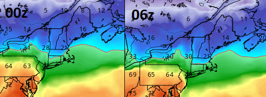
Which threads would those be ? - just curious... because according to my recollection, I have started one thread this year. And it was a system that broke records and wreaked fatal havoc - the scope and specter of which should have had a thread, regardless of myopic intent with this pastime. I dunno...maybe one other. But really, no one has really had much needs to start any event-specific threads. Also... the 06z hardly constitutes the 'the warm move back N' .... the 00z was colder than the 12z ( Euro), and so the 06z ticked essentially that same delta ...the other direction. It may be more indicative of this nesting into a final result. But there is still only so much synoptic room for this to go back N, and in fact, there is still room for it to come S more. I suspect people are hyper focusing on the isothermic layout ...and so the 06z Euro vs the 00z, for 21z Thur ...this difference somehow constitutes a big warm change? Not sure where to begin ... Those differences are far more modest than the melody in here sings. And it was one run.
-
Saw it... yup. The 00z oper Euro tried to remove NS off the face of the Earth with this thing - btw. It backed off quite a bit at 12z though... The EPS and GEFs is a nice cross -guidance appeal, no doubt.
-
mm..it's not likely to be protracted - as in multi threat spanning a week to 10 days... Probably, once we get one it's done. The NAO will likely retrograde and pin our beast in place and then the two wane in tandem... as the storm drifts away kind of thing. May be another NAO pulse 10 days later in March - I'm just basing that idea on the seasonal lag/blocking tendencies we've seen as a repeating spring theme over the last decade. I feel that is tied into changes in the global circulation mechanics which i won't get into here.. But it has been reproducible, regardless of the exact cause.
-
Yup... that signal ( actually begins 27 and end Mar 3 if want to be fair to the totality of thing ...) is an 'index-scaled' scenario. I think I might have even mentioned that early in the day but I've been doing this like a mad man.
-
I actually gave this a shout out over in the 23rd thread... ha -
-
that's why I'm keeping this a moderate affair ... for now. I mean, there's not lot of wiggle room to make this more than what we are seeing... It's a pulse of pretty significant wind mechanics zipping through the interface between the PV and the S warm wall... The polar boundary is just what Will said, more like a stationary front with flop over being pulled up the elevated frontal slope by restoring mechanics on the equatorial side of the exit/lateral/entrace jet max passing by just N. Gfs still carrying the 28th event ( btw...) not to stray on this thread... That's a potent consistency in the GFS, now also inside of D10 ... pinch us, we're almost spoiled here! no but the GEFs have been trending to an actually vision, and not just buckshot from Michigan to Bermuda...
-
jesus ... what'dya reach for the powdered concrete instead of the corn starch. How does one just manifest clots - seriously.. sounds scary
-
It's not a typical SWFE .... Like I just said to Will... the frontal structures and the forcing aren't gaining latitude. Think of it like this ... a warm front extends from southern Ontario to Boston, and the MCS travels along and to the right of the boundary ..pulling it back S... not sending it N
-
Personally believe it will continue to correct S in this case - ...it's bit different than the typical SWFE. For one, it's not really lifting along that type of azymouth. This is running longitudinal, straight W-E so the advection is almost exactly compensating for the cold exertion beneath, and they end up in stasis - but where ? In other words... we don't move from heavy snow to weak IP to light drizzle then end. We stay in our ptype hood. I'm imagining mid way Pike to rt 2? with snow --> IP along the Pike then ZR... Ends as freezing mist, but the event has a second pulse Friday as the 'main low' trailing smears through. Redevelops you ptype, ends as flurries... nasty cold slap Friday night sets up a spectacular Saturday morning scenery..
-
Having said that ...I do suspect south corrections may overwhelm any attempts to bump back N - but wouldn't totally rule out a run or two setting off panic tones... LOL. This doesn't appear to be a situation that would wholesale end up back N to me. But we'll see
-
yeah,... this is a moderate impact event, overall? I wouldn't expect more, just in general. Snow... In fact, maybe less where icing. Typically 2/5ths of an inch starts the timbre sound off, and weakly hung utility points ... really you need 1/2", which I believe is the warning criteria for ice. I don't see this happening much beyond that scale. The cold is likely - I see it ...- to be really compactly compressed against where it just ends up 33F... such that there ice region is very narrow. Also, it's unclear if the lift mechanism hangs over the icing layer, or if it peels N and leaves that region with pixie dust and freezing drizzle making what rimes sort of 'glow' pail. Overall, I suspect this is 6-10" of snow where ever is getting charmed, and 2/5ths icing in a narrow band S ... leverage in some IP in between. We may have furthering trouble a few short days later with a more index-scaled signal.
-
ha... oh man. The icon - yeah, iconic symbol of how NOT to formulate an atmospheric model. Sorry to throw it under the bus and nothing intended toward the Germans but ..... no, don't do that.
-
I'm not sure exactly what you're asking? ...is Philly in contention for this..?? If so, no ... this is a gradient contingent scenario, compressed along a relatively narrow corridor .... like I said, 'probably' within 150 miles N/S of roughly I-90/Mohawk Trail/SNE/CNE/NNE
-
For now I'd say that is higher ice to IP ratio/result ... from there up to the Pike and down the Pike length... but tuck getting under way mid day Thursday - if it is even identifiable at that time, probably makes the eastern end of the Pike more IP/pixie dusty.


