Typhoon Tip
-
Posts
44,237 -
Joined
-
Last visited
Content Type
Profiles
Blogs
Forums
American Weather
Media Demo
Store
Gallery
Everything posted by Typhoon Tip
-
well, to be clear. The hurricane numbers 'matches' the memory pretty well. we were speaking about the increased - apparently so ... - of sub category TCs to affect the upper MA/NE regions. this latter aspects is the point of interest
-
This statistical overview has to do with at or > hurricane declarations? Earlier/recently in this thread there was discussion elucidating that while hurricane "drought" is noted, the advent of TC with lesser intensity may have actually improved over recent decades - since ~ 2000. This was speculation, mind you - no declaration is being made. It's more of a curiosity where it seems so, and if so ... why. Less hurricane in lieu of > frequency of forgettables. Interesting if the number bear that out.
-
Fwiw, the solar activity does not, however... just sayn'
-
I'm beginning to suspect we've been getting some 'harmonic' sort of feedback between the heat genesis and the ridging. The warm Atlantic SSTs are contributing to positive node in the N. Atl basin ... while the unique heat potential of the N/A continent W of 90...100W is servicing helping to anchor that aspect. The nadir between is mathematic Intense thermal ridging adds by driving an intense thermal wind vector that when acted on by the C-force, it bends anticyclonic which is the mechanical constructive interference. In a sloppy sense ... the 'ridge protects itself' It may help explain why our 'warm than normal' summers over the last decade(s) has been ballast in the overnight lows/DP contribution to elevating matters rather than stellar highs. As well as the transfixing nature of summers incapable of bringing the goods east other than transience.
-
it was never going to be west - not with the modeled hemispheric circulation mode. no way. every TC, the models will put out a cycle or two at D6 to 8 lead whence they attempt to violate geophysical mathematics. lol ...Annnd summarily, dopamine drips.
-
Narragansett does pretty well with that
-
Next !
-
Hugo was actually a heart breaker for cane enthusiasts ( of the 'totally responsible mentality' ilk lol ..). I mean, it was a long ... looooong ass tracker that made the entire distance along a clad climo trajectory for ECer's of lore. Even passing within 60 naut miles N of PR... You know? there's this ISE, which is both cumulative for seasons, and for individual TC life. Integrated Storm Energy. They should one like ISD, integrate storm dildo. ... it's basically proportional to "the length" of time and space the given system justly spends within the realm of reach and hope without reach-around
-
Yeah... farmer John's recollection here ... We've observed a lot in the way of decaying TCs that have lifted along the EC - in fact, that sub-classed traffic seems to have increased? "Gloria" in 1986 was the last MDR long track text book express, but it left something on the table actually because between passing the latitude of Cape May NJ and landfall along L.I. it dropped all the way to Cat 1. Kind of a rapid weakener. "Bob" in '91 was a home grown ... but with it 'hooking' right so much it wasn't a higher population impactor. What I think is interesting is that while it is likely more true than not, we've had more favorable set ups in recent decade(s), we have also seen an increased number/frequency of those sub- Cat 1 type cyclones. It's interesting what/why for this latter increase - as its own story. But otherwise ..we should consider Hugo ... Irene ... Sandy, which 'sort of' did but did not happen to key hole the right parabolic track. I don't even know if Sandy was an MDR ...but for brevity's sake. Hugo missed entirely, but hit the EC nonetheless. Irene was mangled by land too much; got too far west. It was also moving rather slow compared to 'express climo'. If that had been more east of its verification, I'm not sure that slow rate of ascension would have survived the colder shelf waters S of L.i., anyway. At the end of the day, it seems we've seen increased frequency of favorable synoptics, without a big pig.
-
Plus ( no pun intended ...) the curve is not linear? you know that, but from what I sense, there is a kind of lingering air - if not assumption - of linearity to this thing, in a systemic change that is clearly become more logarithmic - or has been exposed to be so at this end of the curve compared to the progress of CC between 1980 and 2000... It's as though saying one thing, but not truly in sync with it. Even in the ambit of higher climate sciences and the ethical leaders ( as few as they are in this latter group), there's a lapse in projecting the upward parabolic trajectory. All the impacts so far registered that are either in or have been through attribution science, were predicted to occur later than they materialized. There are also new impacts that were not anticipated by the tech and purposes, altogether. Such as the marine heat wave phenomenon. The impacts on the mid latitude circulation modes during winters...etc...
-
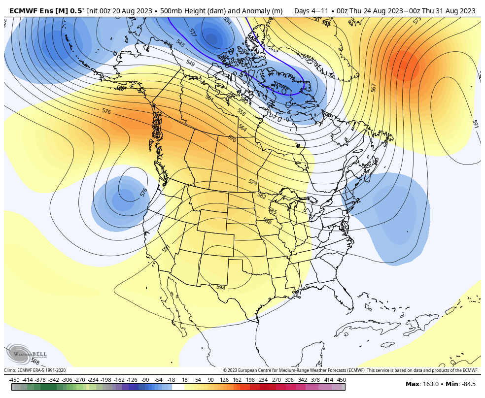
While the higher continental heat is trapped in the west, the end of this Euro run looks like an evolving steam bath along the EC all the way up. You have heights rising/bulging back NW aft of a tropical cyclone escaping into the N Atlantic. That's gotta be soup
-
Yeah... I don't like the expression, but not because I loathe summer. I don't like it because it's pointless - I blame myself, too... Because I remember using that expression back in like 2007 or 2008, and it's stuck. Now ...I'm not sure I'm the one that brought that expression to bear, but I don't recall it used prior and regret it that it's been used ever since. It doesn't make sense, either. Truth is, it can be in the 90s through September 10, any given year, ...even after it has only seemed as though the corner was turned already. I was doing it in a moment of whimsy/jest all them years ago, and now it's like some kind of metric to get those that love winter onto their course of dopamine recovery LOL... But those that need back break want to start actual internet squabbles over it. heh
-
right, the article I happened by spoke of 'southern' France - hence 'similar' not sure how far n the anomalies are spreading
-
How about France ... 104 F for days in a heat wave at latitudes similar to ORD-BOS.
-
It's pretty clear that at least for us here in New England ... SE Canada and the eastern OV for that matter, "summer's back was broken" ( I actually hate that sentiment -) when that front cleared the region back on July 29. Earliest I've ever seen a season try committing to the onset of seasonal change, too. Typically the back gets painful and the season tries to sit down Aug 20 ..give or take. But this was actual break, an entry into what really appeals like we've been in (Autumn + CC)/2 ... something like that, ever since. Anyway, the big over top high with 552 dm hydrostats engulfing the area ... now D6 on the most recent run of the operational GFS, has actually been on the charts for some 8 cycles of consistency. Seems it's real.... That's going to frost in climo cold holes of interior Central and NNE. It won't be pervasive enough to raise headlines, but it'll be 40F at 5am with isolated 35 car top glisteners ... I see the backside woosh and bounce back attempt out there beyond? But I doubt it. This persistency of pattern to carve out the circulation mode over eastern mid latitudes of the continent ( I suspect - ) is more than merely a "pattern" in and of itself and is tied to some other hemispheric/planetary phenomenon. I mean it's a pattern, but because of the latter, it's exceeding the standard 45 and 90 day interval/philosophy on that. It's more changing/going to change at the rate of seasonal migration... digress -
-
Lol, you nailed it on the first paragraph. But the second paragraph hmm. Last winter was both per my own observation. I saw the gradient go from above normal to more normal, oscillations that seem to last two to three weeks, but biased in favor of more gradient. I’m not refuting - I’m more asking really because I saw a lot of that gradient saturation at times. But yes there were times when less. There are two types of that velocity problem, though… One is direct shear related in terms of fluid mechanics. The other one is related to wave propagation speed. What I saw last mid winter was kind of a relay between progressive wave translation vs -
-
Most tend to hoot at the notion but the climate change signal is large swing variability with increased short duration cold latter October through November into early Dec ... Then, gradient intense hemisphere with higher tropospheric torque during mid terms lending to more rain/ice. It seems to be taking place despite the antecedent ENSO variance, too. We'll see.
-
today feels completely normal for Anguish 20th
-
the persistent 80 ... 90W trough leitmotif this summer does offer some intriguing questions should one of these approach the "key slot" from N of PR to the outer Bahamas. It's not like that recurring theme makes that one factor hard to imagine happening... However, the weak and expanded HC is not the best circumstance. Home grown would be better... obviously. But for MDR puppies, they'll tend to get picked up too early by briefly plumbed troughs or weakness. Beta drift will become dominate track guidance early in life, when the steering levels are weaker ...which then added to the former lowers the total shitty chance scenario. It doesn't have to be coherently observed ... we're talking tendency here. I don't know if the trough is even going to be 80/90W. It's modeled to come back by D5 in some products. The EPS is completely wrongly constructing the hemisphere day 3-10 on the 00z guidance but...there's likely some members farther west with that axis.

-
There's been a signal via telecon that emerged some 2.5 weeks ago. But where? right - Persistence argues brightly ... not in New England. And frankly, what's emerged since among the operational guidance members, is a compromised(ing) solution between that aspect you've been musing over ( the trough reloading for different reasons imaginable ..heh), and a west biased climo dome. I don't see any reason why said compromise cannot be so... We'll have to see. I'll just reserve one observation ... the ensemble means are more coherent than the operational runs have been, and... offer some suggestion that while the ridge is likely west biased ...the eastern end would still allow under belly heat episodes. I'm not sure the runs overall are not too amplified over the Maritimes, too -
-
Wow epic morning. 72/57. Brilliant sun so gonna warm up but for now
-
Obsevationally ...seems these scenarios are emerging already - perhaps their coherency improves in future seasons and years, but already there's 'tendencies' I also have a hypothesis that there is a unique feed-back ( constructive interference) circumstance between western N/A 'heat genesis domain' and your descriptions above. The CC signal is tending to transfix a R-wave structures ... perhaps in no small part due to the processes that you're speculating. That domes the west, then within ...particularly high/favorable surface kinetic generation eventually integrates heights and adds back to the super-synoptic signal. It would nicely explain why modeling was consummately showing extended range ridge eruptions over eastern mid latitudes, only to have them decay moving extended ranges into the mid range ... and it did this - as far as I can tell - every time, since late Spring. It’s as tho the physics don’t or slip emergence of these synergistic results farther out in time - which probably makes sense considering. Here we are, attempting to raise heights again ... we'll see - so this is kind of twofold - I’m talking about both climate change related matter… But also how perhaps is effecting guidance performance over the N/A continent.
-
Come hell or high snow of a winter across N/A … the ambient hemisphere will be velocity saturated at mid latitudes. bank it-
-
What does “@typhoon_tip” mean we’re you addressing me ? not sure if that’s an accident of the interface It comes back to A ≠ B ... weather happens (ie, gradient is the difference between A and B ), vs the A = B test state ... nothing happening. “modularity” is the actual event(s) moving the A ≠ B state toward the A = B
-
mm.. the majority of guidance ( the NAM is just on roids for some reason ) closing off contours with some kind of coastal is ....well, kind of doesn't seem realistic but be that as it may, if that happens... ? nothing but heavy rain bundles