

Typhoon Tip
-
Posts
44,541 -
Joined
-
Last visited
Content Type
Profiles
Blogs
Forums
American Weather
Media Demo
Store
Gallery
Everything posted by Typhoon Tip
-
man... that Euro run last night was a top shelf shit show New England spring special - just vomit wow
-
I get it... I'm being snarky on purpose lol
-
I doubt it... it's more likely that any reputed source that tends to be right ... isn't really wanted, because it too often gets in the way of whatever the daily meme or narrative is - usually a departure form objective reality/rational insight.
-
yet y'all have time to be engaged in this "pass time" as far as the statistics gather, >50% of waken hours.
-
This isn't hanging around long enough for that
-
I like the RGEM for this thing... went over why yesterday but no one reads what doesn't fit on a tweet any more
-
Yeah, I was looking at that but it does it on a northwest wind. I’m a little suspect of that. Synoptic scale snows upwards of a foot doesnt typically happen on a northwest wind, and this isn’t that kind of backward tilted deep cyclone. Looks a little dubiously like typical NAM ANA bullshit
-
I'm on the fence with this... up through about Feb 20 give or take, it's an easy assumption this is busting too warm in the BL, in the guidance across the board, given to what is advecting into the region out ahead of arrival. I don't know about March 20th tho. In the end I'm inclined to think guidance isn't fully resolving the BL when it is this cold. The low riding up the front passes SE of ORH - an ageostrophic trigger and the 925 mb layer typically gets under-assessed in these synoptic scenarios. And I'm really more interested in this air mass' thermodynamic properties. DPs are 9 to 17 throughout the area and there is no real modification means between now and Saturday. It's probably more about whether we end up with IP or icing in that transition region, as well as how long it lasts.
-
Mmm Steve's right. Adding to that ... the EPO drum began to beat in the telecon projections for the 15th - 25th since really the 'coherence range' first came over the temporal horizon ...circa late February. At that time, the outer edge of extended range tipped the index into a dive entering week 3. It never backed off ... In fact, the projections kept lowering the SD nadir further, and also extended the length, all the while people were bickering about how much this year is comparable to 2012 ( why doing so in the first place struck me as just needing something to argue about as a recreational activity.. ultimately, meaningless). I realize the antecedent winter has driven folks probably to being jaded beyond the capacity for objective consideration... but too bad. Considering there have been milk shake blizzards in the first weeks of April - Anyway, enjoy abeyance of spring.
-
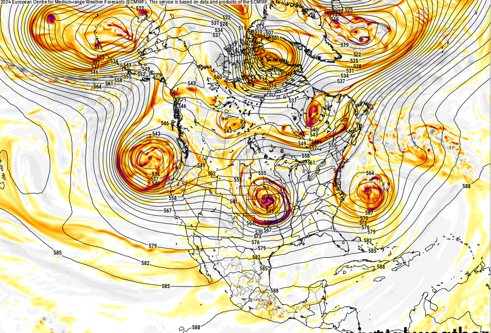
the thermodynamic properties of this air mass are talcum powder tundra snows tho. how are we moderating this very cold thermodynamic aspect prior to the arrival of any mid level WAA fist? that's likely what the RGEM is seeing here. the NAM has a routine NW bias ... particularly outside 36 hours - plus, it's the NAM. fwiw, the ICON has been RGEM like for several runs now the other global models have been suspect as the Euro early on in this thing had zip...while the GFS was going gonzo. then ...the GFS backs off (some) and the Euro is presently huge. the continuity isn't very good in the general synoptic scope. that said, even the GFS seems ( this 12z) to respect the bl resistance with 6 hr belt of IP down to the MA/NH border, when at the same time it's probably no resolving below 950 mb very well so ... i think this has a shot at being a surprise cold profiled relative to one's latitude.
-
If this were all last month X 20 years ago ... near warning ice would likely set up from Orange Mass to Concord NH
-
I know we've been over this before ... but it's idiosyncratic and dated conversation, neither of which lends well to the general reader. We have been having trouble phasing. That's the short version. Longer, it has been a recurrent problem in winters going back some 8 years. This (obviously) was not true all the times, but the reason (imho) why makes sense that some better phasing performing months have been like March 2018. Hint, the flow slows... phasing has more success. - too much velocity in the hemispheric medium. Phasing requires a narrow velocity ratio between N-S motion, vs the W-E ... Particularly, ( I'm just speaking to the generic reader here - ) when the W-E is fast, the S/W embedded bi-pass, or may partially succeed... but the true subsume/captures become physically challenged. From orbit this just looks, in general, like the N/stream is just nuance interfering like you say.
-
Climo or not it's brutal ... 25 with white noise tree leaner gusts? ooh baby. oil us up. The perfect way to herald in the post equinox era.
-
Yeah, I wrote a longer op at above, in which I spoke of synergism in total manifold. A cocktail of non-competing, constructively interfering forces is a plausibility that I definitely endorse.
-
Yeah, something like this sure. Last year was a clinic on how the systems are multifactor guided
-
It depends what is meant by "related" in the bold. If by that it coincided - temporal - than sure. However, global temperature response should not occur in the same temporal frame - the atmosphere has a noted lag wrt to warm ENSO phase. Last March, the air and sea well outside the ENSO district ...everywhere, bombed temp apace and faster than the onset; that does not fit either statistics, nor baser understanding of geophysical "relationship" between air and sea - Think of it this way, the El Nino has to couple to the atmosphere first - it was not coupled when the heat flash took place. In fact, the flash took place when technically the La Nina was still on the charts ...in process of attenuation, but still observed. The El Nino was in fact manifesting underneath and I would also proffer the reason the super Nino failed is probably because these outer modes were in some variant of destructive interference.
-
It's weird ... NAM's 500 mb thicknesses are < 515 over Logan, and < 510 over BTV ... that's pretty impressively cold. I don't think it was that cold in that particular metric at any time during this last winter
-
Bowling season has arrived!
-
19 years ago ( jesus christ ) I worked at WSI for a coffee break. While there, I had access to the Euro's entire suite. I recall the operational version actually had panels that went all way out to 360 hours like the GFS. It always had a big bomb beyond D10 - or seemed to... I'm inclined to suspect this AI version is just giving us what the regular version always has in that time range -
-
It's become abundantly clear that the Euro AIF model's real purpose/intent by that organization is to advertise ... because since it was foisted as free - no less - it's consummately serving a Burger King commercial of a bun sandwich in that time range. Speaking of which ... when are the models actually going to progress seasonal change? It's another hang up of mine. Every year at this time, the models try to keep Februaries rollin into May.
-
I mean it's like above normal or below normal ...neither matters and the engagement/conjecture over it all could not be any more futile when considering at this time of year, they are both a creepy scene in Shawshank Redemption with this New England prison we call spring - unless the above normal is like +38 F or something. ha
-
Nah... not to sound dismissive (ha) really but that doesn't explain why both air and sea from pole to pole unilaterally increased prior to the onset of the warm ENSO phase.
-
I think the distinction that global SSTs have "peaked and are starting to fall" isn't very well supported if one is using the graph above. Looking back along the character of that curve, it is highly 'serrated' with interim periods that were both increasing(decreasing) but quickly resumed the previous dynamic. I don't disagree with what you were saying, overall ... just speaking to that point, specifically. We need more time to determine if that descent qualifies as that.
-
It’s one of those uneasy laughter moments…
-
I was musing to self last week ... maybe the ending of the over-lapsing solar cycle minimum, nearing its end, might have some at least partial factorization in this. The solar mins are defined as period of decreased solar activity - less than the longer term average number of sunspot behavior. That also includes lowering(increasing) numbers of SFs and CME activity, depending on min or max, respectively. In addition, solar cycles effect the average brightness of the sun, which directly raises or lowers the energy to the Terran surfaces - as much as 1 watt/sqr-metter; this variation when all told after absorption by the total Earth system, ends up adjusting the temperature up or down by as much as 0.1 degrees C. So, I'm wonder the following: In 2005, the impending solar minimum warned as being a super-position along two temporal variances, the 11-year, and a longer period 22-year periods. The collocation of these period oscillations at the time lent to the educated assumption, an unusually quiet period was imminent, the character of which meant minimums, over the course of ensuing 15 to 20 years, would be of greater negative magnitude than any intervening maximums intervals within. What is also interesting is that the planetary temperatures have risen straight through these lasts 15 to 20 years, despite the 'educated assumption.' In other words, what happened to our -0.1 C offset? The thing is, 0.1 C isn't a terribly large number, but... if it were being suppressed by a more dominant global warming signal, that could account for that. But now, suppose there was a "synergistic" effect, due to several non-competing factors that suddenly came into existence nearing the spring of 2023? Basically when you superimpose, in time, favorable disparate forces, the outcome can be more, sometimes much more, than the sum of the individual forces...etc... One source being the implied increase in the total irradiance uptake nearing the end of the solar min ( I haven't seen any calculation/papers on that specifically ... bear with the speculation here ). The other perhaps being, there are numerous articles ( paraphrasing papers on publishing sources like phys.org etc ) that outlined secondary and tertiary possible +thermal responses directly or indirectly Tonga eruption related. Poor timing perhaps in having that event coincide with even a subtle uptick in the solar flux; even though this latter aspect is small, dumping more energy into a 'prone system,' one that is repeatedly demonstrating it will warm up with lesser physically exerted excuses to do so? Such that then combining ... may not end so well. This could be a cocktail of positive feedbacks contributing to a synergistic global thermal response. Which, I'm sure physicists that skulk around the web for ideas that they, with the wherewithal to investigate far more readily, ...will publish a paper that does not credit the source for their inspired idea LOL ... kidding. But one way or the other, I would not be surprised if something of a publication surfaces soon that begins to connect a synergistic/superposition hypothesis in why the world witness that global heat burst last year. The thing that is peculiar to me is the oceanic SST aspect of that last March-May abrupt warming event. It wasn't just the tropical Pacific ENSO ... the AMO and the PDO and southern hemisphere oceanic basins ... well away from the tropics, also simultaneously warmed. Which is why - in part - I enter that solar variance is a plausible, at least partial factor there. You know, what ended the Cretaceous era and the mass extinction that occurred along that boundary is largely attributed to a large asteroid or comet impact. However, as paleo biology will point out, the system was becoming unstable for them prior to the advent of that rather enormous straw on the camel's back. The idea of setting up the Earth systems with proneness, then having poor timing in multiple factors arrive to bring the house down ... that is not unprecedented. Science has exposed other mass extinction events also having multiple overlapping aspects taking place, where back-ground adaptation rates where exceeded by the deleterious assaults in multitude. Whether we want to believe that human activity plays any particularly crucial role in setting that table this time or not, that is not coming under the microscope in this op ed. I'm just wondering - in general - if we are bearing witness in real time, of another overlapping. We are, as already defined by empirical data, living ... or perhaps more so than we are even cognitively aware, "surviving" a mass extinction event. Creepy to suggest ... but perhaps all this is already academic.


