Typhoon Tip
-
Posts
44,539 -
Joined
-
Last visited
Content Type
Profiles
Blogs
Forums
American Weather
Media Demo
Store
Gallery
Everything posted by Typhoon Tip
-
Seasonal smear is already pretty obviously swept over the hemisphere... These systemic llv gradients are normalizing on either side of boundaries. It's one of the reasons why the 11th is sort of a blown up ravioli look with a dispersed cyclonic pressure pattern... because that focus feeds back on the vertical structure, and helps deepen it further ...which in turn carves the trough to a more southerly latitude ... lot of feedback mechanics are gone and we have lots of S/W still capable aloft, but with comparably weaker organized surface lows as a result. But what we are seeing is PWAT anomalies. Gee... unusually early springs? More rain than is normal relative to weaker systems? I wonder what could be causing those.. But it's not committing to warmth, either. It's just making things inCREdibly boring. At least the clocks go ahead in 6 days. Get out of work in 58 F with still some daylight is at least seemingly better than dreary.
-
wonderin if we can sneak in a flood threat Thur night
-
Yep. … I noticed that when that happened, we started repositioning the ensemble mean, and a lot of the mid upper features the whole everything of it, more N too. It really seems that we have this multi season plague going on where the true northern Stream and true southern stream can’t play nice together.
-
I'm still suspicious about the version we've been fed by that organization over the last 2 or 3 years. I wouldn't put it beyond the realm of possibility that we were deliberately given a regressed beta version in preparation for this next gen roll-out. Kind of a 'calculated risk' to up the profile of the new version while not too seriously compromising performance. But ... we're kind of a hyper sensy sort in here and notice things. I mean I just find it hard to believe in blanket statements like, "ever since they updated it its been a piece of shit" as though some bug or error or incompetence got through QA. These are post doc scientific engineers - they're just not that 'stupid' ... I find it more likely that they knew/know all along what's going on.
-
? I thought that was slated for July 1...
-
Yeah ... the ensemble means are still carrying on with an impressive signal overnight wrt to the 11th but there are plenty of reasons to doubt whether that'll mean much in the way of wintry result. One aspect that is probably of lesser importance to most in this forum is that there is a new moon/spring tide between the 10th and 12th. Some of the spread members of the various ensemble means are less than 980 mb ... and powerful Nor'easter implicated. This system should be watched for the combinations of those factors.
-
It actually passes over the islands just about as deep
-
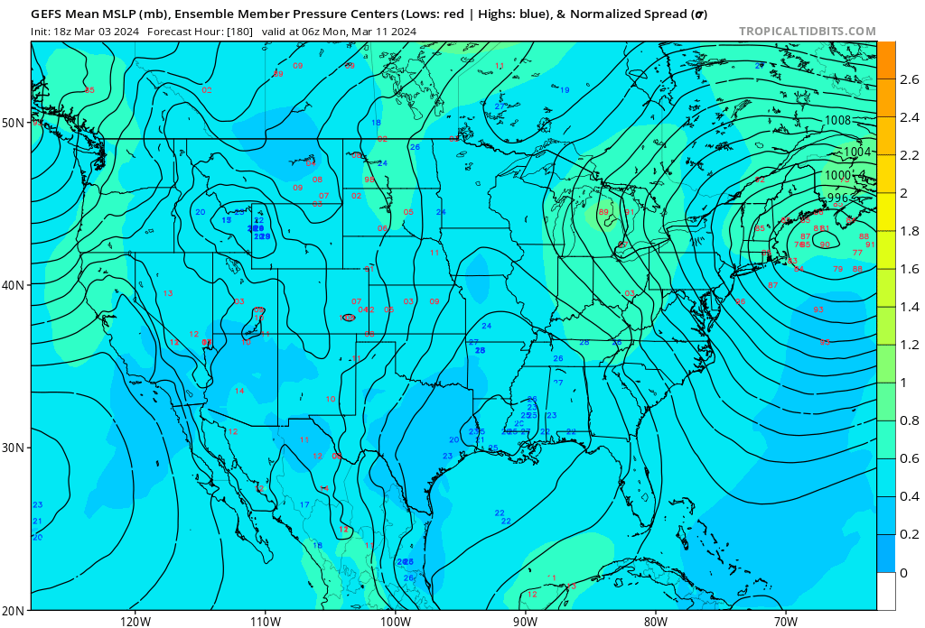
This is about as impressive a signal as your ever going to see at 180 hrs

-
We’ll … you’re certainly lucky to have been born into this era of increasing acceptance -
-
Re the 11th Late blooming IP blizzard on the Euro... strange looking for a CCB head to do that but that's probably a nod to dynamics winning that, push come to shove. Major bomb on the GFS ... position less meaningful at this range. Whether that happens as is or not, the general/local hemisphere-synoptic evolution reminds me of 1997 late March. Fits my personal recall. Even the ensemble mean bears a likeness, having a well defined multi-contoured low at D7+ range, with spread back toward the coast. Mid and u/a low cuts off and deepens significantly in the op version, easily too close for comfort there. GGEM is warmest but it too reaches <980 mb pressure as it is leaving... All this is 180 to 200 hours out, offered up while their respective ensemble means are lit up with an obvious and continuous signal between Cape Cod and the BM. Interestingly persistent considering they picked this up at the 'coherence horizon' some D12 or 13 in advance. All of which is taking place in a saddling NAO index in the process of retrograding from eastern toward western limb orientation, while a +d(PNA) is underway. The atmosphere is marginal, but given some of these dynamical juggernaut solutions ...you could even do well with marginal+ as the kinematics are sufficient to overwhelm. The only thing stopping me from threading this event for early awareness is the modulation antic of typical March. I have seen a lot of these bigger majors normalize. Plus, we habitually see the models over amped at this range. If this were January ...different story. I'd say if we make D6 and this coherence is stayed/improves ... It's also a New Moon/spring tide concern late next weekend/11th
-
Wind turned E … that was a katabatic compression of an already anomalously hot air mass. The emergent synoptic circumstance had never been seen - it was determined to be CC feedback upon attribution science. Bringing that freak high kinetically charged, low DP air down slope was a death knell.
-
People forget we had about 24 inches of rain in 50 days in December and early January much of which fell in the 30s. actually check that… Just seems that way
-
It was like that many times all winter long down here – no sympathy. Lol
-
It is less likely that we will ever experience a synoptic/synergistic heat burst the likes of which they experienced out there, because of where we are situated with respect to the rest of the continent and the adjacent Labrador current. When we are not being fiddled with by the ladder cooling influence… our air mass is a result of having collected the bio ozone and or subtropical inflow off of the southwest Atlantic basin. We are a more humid baseline summer atmosphere, which is not conducive to temperatures rising to between 110 and 114° By circumstance when our dewpoint are low in the summer, it is typically because of kinetically cooled air mass from Canada There’s a reason why the ballast of our warming climate expression here in New England is in the nocturnal side of the diurnal. Fromunda’ dewpoints keep the air back-a ballz sultry at night. People have to understand that climate change means holding more water vapor in the atmosphere… Anyway, if it ever got to 104/76 that’s hot enough anyway because the heat index would be probably comparable to what they got out there and that would be the way that we would do it through the HI
-
I've always imagined a scenario where I had the wherewithal to flee this New England taint season. I'm willing to risk the historic bomb, because they are just too rare to bother. I'm also willing to risk the fair day in April, because those too are just too rare and not enough of them. April should not exist on a God intended Earth ... Mostly from about March 15 through May 1, what you get is what's going on out there right now. Light rain/40s F
-
EPS was an improvement. GEFS/GEPS hesitated just a little
-
yeah that Thursday thing's actually in the way of the latter one.
-
GEPS/GEFS were also weaker by some ...
-
It's been there since the time period in question first emerged through the outer 'coherency horizon' Like 15 days out lol. This particular 12z cycle is actually less than previous, but at this range? -that's allowed. I'm not dubious of the signal, per se. I am however leery about background seasonal change. There have been plenty of significant storms with frigid cold and wind hauling talcum powder ...all the way to Easter. If we are going to be lucidly rational about our chances here, however ...for every week that goes by climatology lowers those odds. But, I feel ( probably not a shared vibe, okay - ) like our climate has shifted shorter. Springs are earlier. It's like March 1 2024 is March 20th 1997. I was thinking that last week, and then some of these individual runs kind of started looking like April 1 back whence. I was like, 'no shit' ...Even if only hinted it's supporting my point. Anyway, that's conjecture. I mentioned a couple days ago that this was a candidate for holding off on a thread until perhaps 5 days. I don't hate the telecon spread for this. I just don't like the climate smear/seasonality shifting shit, combined with the sun modulating b-c fields
-
We spend all this time obsessing over the Arctic when in so far as climate change ramifications is a concern... it's the other one that's the biggest problem. https://phys.org/news/2024-03-scientists-fret-antarctic-sea-ice.html But... I don't really think a lot of the Arctic focus in here is really about climate change per se. More about preserving chances for cold and snow in people's winters, and having connected that to the state of north pole. Call me a 'motivational cynic' -
-
Poke and run on the hornet's nest here but that's GEPs mean is ...well, pretty 'mean' looking considering this is 200+ hours..
-
Zip continuity beyond D7 ... but, no model is really required to in that range anyway. Both aspects in that sentence all but completely require not even being allowed to post that shit LOL
-
The operational run is a cold outlier at 850 mb on the evening of the 10th. Despite the growing coherence in the mean/distribution products, the ens mean is quite a bit warmer than this above in the antecedence to that 10/11th system. One might think it would it trend colder as we near, or else the baroclinicity comes into question and the whole thing ends up an elevated gyre. Warned this in the past.... the big cyclone extended range systems of spring sometimes deteriorate in the runs as they near, because the b-c gradients get homogenized by the time of the year. But, maybe the oper is onto something.
-
should be able to label a model run for what it is, though. People tempering or not tempering expectations? I gave up on that years ago ... In fact, it is unlikely that would ever work in a returning usership that is in fact "suffering" ( whether they know it or not -) from an addiction complex that requires they actually get their expectations elevated. So fuggit ... describe the portrait for what it is.
-
Understatement wrt to that particular GGEM run... woof