Typhoon Tip
-
Posts
44,539 -
Joined
-
Last visited
Content Type
Profiles
Blogs
Forums
American Weather
Media Demo
Store
Gallery
Everything posted by Typhoon Tip
-
Occasional Thoughts on Climate Change
Typhoon Tip replied to donsutherland1's topic in Climate Change
Depends on what ethos is being satirized. That comic is more social/behavioral norm stuff, out there amid our overbearingly scrutinizing, self-aware obsessed society right now. Human behavioral-science -related. Where it matters to a climate science? It is way more apt to suggest that authors of credible, objective science are increasingly more reluctant to publish, fearing a counter-offensive abasement tactic by what is really near-institutionalized denial that is not in the spirit 'scientific skepticism.' -
The last 8 winters here in interior southern New England are sensibly quite similar. They may be differentiable in scalar numbers - getting ever more discrete in one's analysis to prove outlooks. But at some point doing so falls beneath what can ever appeal to anyone's experience. The sensible differences are too small. This is true having leading El Ninos and La Ninas over that short-sided decade. The winters have seemed to follow the same plat layout. Early cool shots and an October/Novie snow and/or snow supportive synoptic washing, fades into mid level velocity soaked shred fest of model bombs at D11 that turn out be busted raviolis on the daily charts/short range. Then, "spring" arrives, the velocities hint at slowing ... blocking results. MLB looks like assholes sticking guys out there in outfields ... shivering in the northern ballparks with even flurries in the air (taking some liberties here for fun - ). I dunno maybe this is was all PDO forcing this. Or western Pacific IOH in a coupled atmospheric state that... It just seems too much energy is devoted to ENSO. It plays a roll, some years more than others. But it's like with everything in this business... it all comes down to juggling wave functions at all scales. If they are in constructive(destructive) interference, dictates how 'visible' they are in the resulting statistics of how a season behaved. Lately, less ...
-
I suppose it wouldn't matter if all teams had indoor parks. But ... to me, it seems sort of comically indulgent to create these hundreds of million-dollar facilities for a game. Having to go to such lengths, some point along the way ... the expenditure might have dawned some questions - I mean you could really go down a rabbit hole with that, ranging from redirecting all that resource into cleaning up homeless, to a carbon footprint of it all ... You name it ... when the virtuosity bends to the point where becomes immoral ... It's all true while we 'make America great again' with our hog-minded pickup trucks hauling our futures to the edge of the cliff. All that and good luck.
-
Why is MLB opening baseball on March 28th at all? get the f outta here with that
-
Heh. I don't recall the last time the weather during a Fenway opener was even remotely appropriate for MLB's "season." When the Bo' Sox send scouts to prospective talent household, sitting around the dining room table, how exactly does that conversation go. The marketing of April baseball and being knuckle struck by a 92 mph up-and-in, let alone even making bat contact at 38 F.
-
It may or may not snow again aside … this is a box of grade A powdered butt f* New England spring, just add water
-
The Congrats Dendrite Deck Destroyer 3/23-3/25 obs discussion
Typhoon Tip replied to Ginx snewx's topic in New England
Man did this thing exit in a hurry -
Occasional Thoughts on Climate Change
Typhoon Tip replied to donsutherland1's topic in Climate Change
Um. What? oh that. Heh. I don’t care. Ultimately a pure waste of that person’s time. It means 0 -
The Congrats Dendrite Deck Destroyer 3/23-3/25 obs discussion
Typhoon Tip replied to Ginx snewx's topic in New England
we just kicked back .5 deg here and technically should be icing again as we're down to 32 on the botton and DP is 31.8. That just happened in the last hour - but yeah, it's not like we have an obvious tuck going on either. We had about .15" glaze glowing but that 32.9 high was enough to eradicate all but the pine bows, which are still sagging some. -
Actually it isn't - As I said, we might have to deal with a -NAO as an option, too. It's weird the model summarily prints that out. Geez.
-
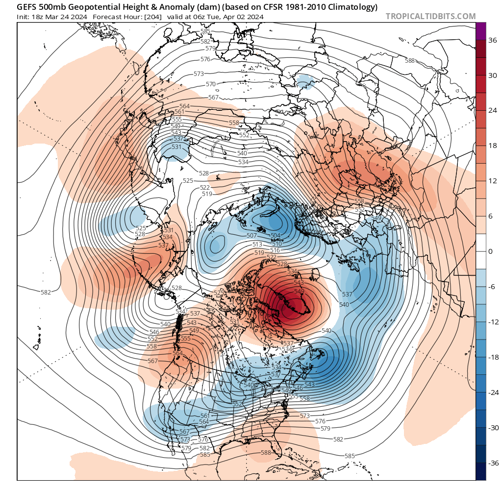
Can you imagine being a lone astronaut traveling at sub-relativistic speeds in the year 2450 ... The Earth is no more after the Quantum Computing Core came into nexus with AI ... and those seemingly lone survivors who were cut ties, they are now technological relics counting down their resources, praying that a habitable world, uncharted, might materialized out of the fog of infinite distances - probably around some uncatalogued red dwarf. 2 or 3 years light time beyond our solar system, maybe just for sanity's sake alone ... they still log their reports. When the reality is there's no one left to receive the message. That's what posting in this thread is like right now. LOL The models alone and in blend, look like this system is occurring on the gateway into milder regime flushing over mid latitude continent. Milder and more spring-like. The 850 mb may still have pockets of cool, or even cool (less like frigid) incursions from the N. But they are no longer back built off a -EPO loaded, -850 mb temperature anomaly mass ... The teleconnectors actually compliment this notion well. With said -EPO gonzo by even early this week. Neutralized and modestly positive from all three ens systems, ECM/GEF/GEP for the foreseeable future out to the end of the runs. The PNA is neutral-negative. This would ( and may in fact) be a foundation for actually driving positive temperature anomalies over the eastern continental mid latitudes. However, we may have to deal with a west based -NAO - less certain. The upshot for spring enthusiasts is that the cold over the Canadian shield by then has lost entirely to a modest +anomaly baseline. I.e., won't be as bad. Considering also the calendar, this may in fact be the last winter event of this season that doesn't require a fluke/bowler event.
-
The Congrats Dendrite Deck Destroyer 3/23-3/25 obs discussion
Typhoon Tip replied to Ginx snewx's topic in New England
Rock bottom day out there around here. 32.1 R -
The Congrats Dendrite Deck Destroyer 3/23-3/25 obs discussion
Typhoon Tip replied to Ginx snewx's topic in New England
I don't think I saw a DP air mass this thermodynamically cold in the preceding winter months. ha -
The Congrats Dendrite Deck Destroyer 3/23-3/25 obs discussion
Typhoon Tip replied to Ginx snewx's topic in New England
and I don't. I think it's okay aloft but would not be surprised if colder holds tough in the lowest layers near the ground. I could see the top of Monadcock Mt 37F while 29 down near the reception lodge at max before the whole thing collapses SE. -
The Congrats Dendrite Deck Destroyer 3/23-3/25 obs discussion
Typhoon Tip replied to Ginx snewx's topic in New England
Yeah ...I know, it's been head scratching why the models overcome the hygroscopic cooling in the BL so easily given the low travels S of ORH? least last check... maybe that's changed. But this has "tuck" written on to me - it's going to be interesting to see if a 950 mb backward jet gets going and over SE NH -
The Congrats Dendrite Deck Destroyer 3/23-3/25 obs discussion
Typhoon Tip replied to Ginx snewx's topic in New England
It looks from that animation that it's not colder thermodynamic -wise but is output colder due to the event being slightly earlier. The whole thing is sped up. You can see because the event exits the western half of the domain earlier. If the system speeds up, it can avail of what cold air there is more proficiently. The sensible result is colder but the why-for isn't precisely colder in the physics. interesting.. -
The Congrats Dendrite Deck Destroyer 3/23-3/25 obs discussion
Typhoon Tip replied to Ginx snewx's topic in New England
icing events in Acton growing up were always neighborhood chimney smoke drifting S. it's a bit of nostalgia to smell that with the smell of accreting ice air. Lamps glowing through windows, while the sound of timber straining around the trees. but that's where it ends for me. When the lamps turn off ... I'd rather it not -
Just N-NW of Maine there has been like 1 to 2mb increases in the sfc pressure among the recent guidance tendencies. I think there's a modest correction vector that points toward the colder solution types - whom or whatever carries those.
-
Split sentiments for me. It would be interesting while it is happening to have this bust colder - event just testing the suspicion that it may. How much, notwithstanding But at the same time, the whole past the ides of March getting on with exiting cold; I could not be more wanting of this latter state of affairs.
-
Not according to NWS .. LOL
-
DPs are regionally between 0 and 9 F out ahead of a flat wave QPF anomaly, with model run to run in +delta surface pressure N of said wave. It's going to be fun watching this thing overcome that cold profile/implication
-
you aren't worthy hahaha
-
not talking about this thing tomorrow. it's that E fetch pile-up misting antic it carries on with. i simply have to procure a second residence to flee to at this time of year. i would have been long gone and not coming back until some higher confidence forecast in May.
-
man... that Euro run last night was a top shelf shit show New England spring special - just vomit wow
-
I get it... I'm being snarky on purpose lol