Typhoon Tip
-
Posts
43,386 -
Joined
-
Last visited
Content Type
Profiles
Blogs
Forums
American Weather
Media Demo
Store
Gallery
Everything posted by Typhoon Tip
-
False, I'm resorting to not being involved when someone is clearly hostile.
-
I don’t have a problem with a system being on the charts then… I’ve been advertising tail out of the month for my own reason along with everyone else… The cold air has been a real interesting mystery this year, but the GFS is actually started suppressing that system in lieu of the Canadian circulation mode – relatively new albeit… – several cycles ago. This is the first one that’s crossed the mix/snow possibility along 40 N.. Canadian looks like it turns that into a nasty ice storm for the interior. Out of a coastal would be rare but we have seen that in the past. I think the main take away is that colder scenarios are finally entering the possibility.
-
Sunday, December 17 - Monday, December 18, 2023 Storm
Typhoon Tip replied to weatherwiz's topic in New England
storm over - very light wind. zero rain. silence -
If your really want some cognitive dissonance ... 'time is relative' hahahaha
-
I'll take that in a heart beat ... That's a fantastically fun look. Slow moving gyre with plenty of cold air on the north side of the bowl. I mean (haha) compared to where we've been? Serve me up a big plate of "blech" then. good lord -
-
Sunday, December 17 - Monday, December 18, 2023 Storm
Typhoon Tip replied to weatherwiz's topic in New England
thing is... S/SSE wind tends to have a lower tree failure threshold - it could be related to that. I mean we've had a wet autumn. The ground isn't frozen... the usual suspects, then repeating 35 mph gusts through a region that hasn't really had a lot of synoptic scaled wind this summer and fall. I remember remarking to Dryslot in our conversation a couple weeks ago, that we realliy seemed to have a low wind autumn. Of course, within a days of doing so, we get a couple of wind headlined events - of course. Anyway, the point is ...lack of 'natural pruning' adds to some vulnerability. The other aspect is that when towns go down, the surrounding towns pick up the slack - this can sometimes cause break switches to trip. They need to send out a boom truck with a fiberglass pole, and hapless lineman with big gloves to poke the switch and pray - I've seen them do this ... because I'm the last mother'fugger on my trunk and the pole is right outside my damn door. I've literally, on more times I care to recall ..., had to phone an outage of 1 single household to NGRID and have then send over a truck. -
Sunday, December 17 - Monday, December 18, 2023 Storm
Typhoon Tip replied to weatherwiz's topic in New England
It's interesting that NWS is markedly lower in that description -
-
Sunday, December 17 - Monday, December 18, 2023 Storm
Typhoon Tip replied to weatherwiz's topic in New England
-
See ... I don't know why you are even turning that bold phrase when responding to anything I just said. I'm talking specifically about the scientific process. One makes a prediction, they test the prediction. Making a long lead forecast, and then being asked to go back and evaluate the success/failure, is that process. Mm ..it sounds like there is a back-story between that poster and some of y'all. Don't combine my ethic/principle above with that story. - if that is happening. I'm not stopping jack shit.
-
Sunday, December 17 - Monday, December 18, 2023 Storm
Typhoon Tip replied to weatherwiz's topic in New England
Ha ha... Could be a situation that overcomes. It'll be interesting to see how that plays out up that way. -
Sunday, December 17 - Monday, December 18, 2023 Storm
Typhoon Tip replied to weatherwiz's topic in New England
Have to check the Oxbow NWS site ( again... about 2 1/2 clicks from here) to see if maybe it clipped them but we just had our best gust a few moments ago.. Easily 50 mph, and an uptick from anything in the prior hours of this thing. It's also coinciding with a bit of bump in temp. 62/60 now -
Sunday, December 17 - Monday, December 18, 2023 Storm
Typhoon Tip replied to weatherwiz's topic in New England
Completely unrelated ... ( haha) still, this is quite similar to what I recall the radar looking like that fateful morning of Dec 23 1997 ... when it was between 22 and 29 F west and north of I-95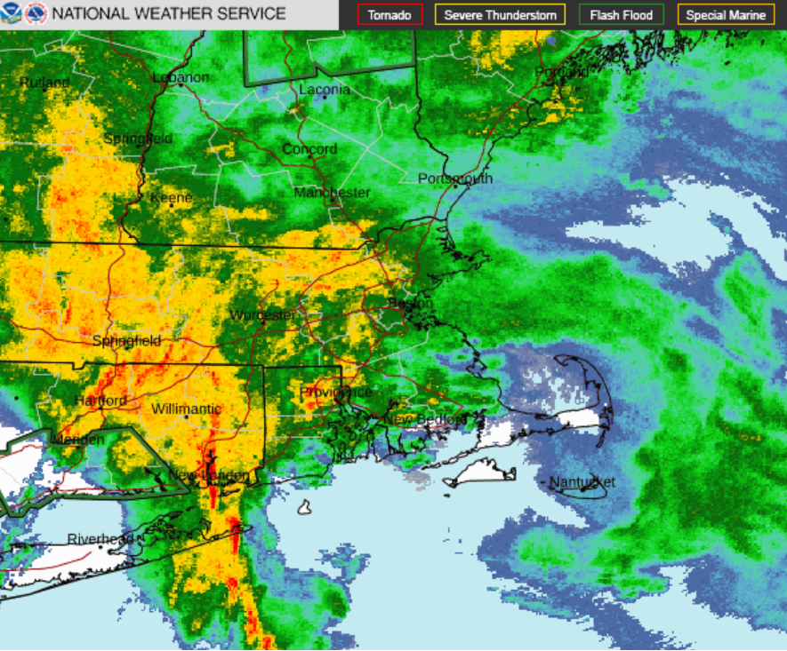
-
Sunday, December 17 - Monday, December 18, 2023 Storm
Typhoon Tip replied to weatherwiz's topic in New England
yeah, I caught your sentiment on that last hr. Thing is, ...I'm noticing - fitting with theory ... - that the shore-point/coastal exposed sites are having trouble with higher end wind gusts. The obvious/most likely cause of that is this air mass has thermally exceeded the SST's in the bite waters and surrounding the horn at this point in the season. In other words, created a cooling inversion etc. I'm wondering if PWM is going to be "protected" some by that? -
Like I said, ... there may be a history there that is contentious? I am not in defense of either side and don't really have any awareness to begin with, and don't care to be involved. The principled approach of evaluating one's forecasting technique, if/when the technique is not successful, IS SCIENCE. period. not open to debate. that's the only point I was making - hence the kernel of value in the this 'edbugg' poster's comments.
-
You're missing the point in lieu of being angry - got it... I won't push any buttons. Wasn't the intent. I'm out
-
Sunday, December 17 - Monday, December 18, 2023 Storm
Typhoon Tip replied to weatherwiz's topic in New England
Next 2 ...3 hours may see some sporadic gusts over 55 mph ... anywhere N/E of this line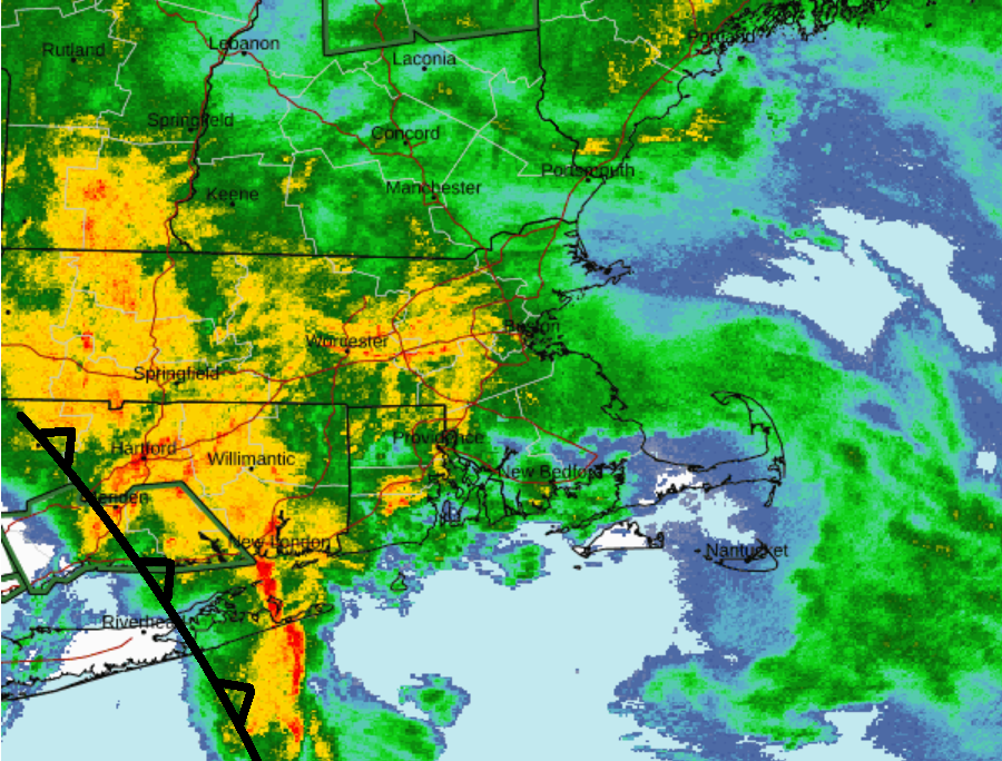
-
Sunday, December 17 - Monday, December 18, 2023 Storm
Typhoon Tip replied to weatherwiz's topic in New England
New highest I've seen -
Sunday, December 17 - Monday, December 18, 2023 Storm
Typhoon Tip replied to weatherwiz's topic in New England
The winds are slackening pretty abruptly ... collocated with that back edge on vis sat/loop racing N. Obs along the western end of L.I. saw winds decrease from routine gusts to 40-45 mph, down to 25 very quickly as that brightening passed in. Hang on in CT! It'll probably be over by 11 am S, and 2pm up near the Ma Pike. -
Sunday, December 17 - Monday, December 18, 2023 Storm
Typhoon Tip replied to weatherwiz's topic in New England
Great Lakes are definitely modulating that aspect of the air mass in this sort of trajectory - -
Sunday, December 17 - Monday, December 18, 2023 Storm
Typhoon Tip replied to weatherwiz's topic in New England
Yeah, I'm wondering about the flooding at this end of Rt poopie ... The Nashua River was way up in the back water above the research dam along the Harv/Ayer line just after that last event so the region may be primed. -
Sunday, December 17 - Monday, December 18, 2023 Storm
Typhoon Tip replied to weatherwiz's topic in New England
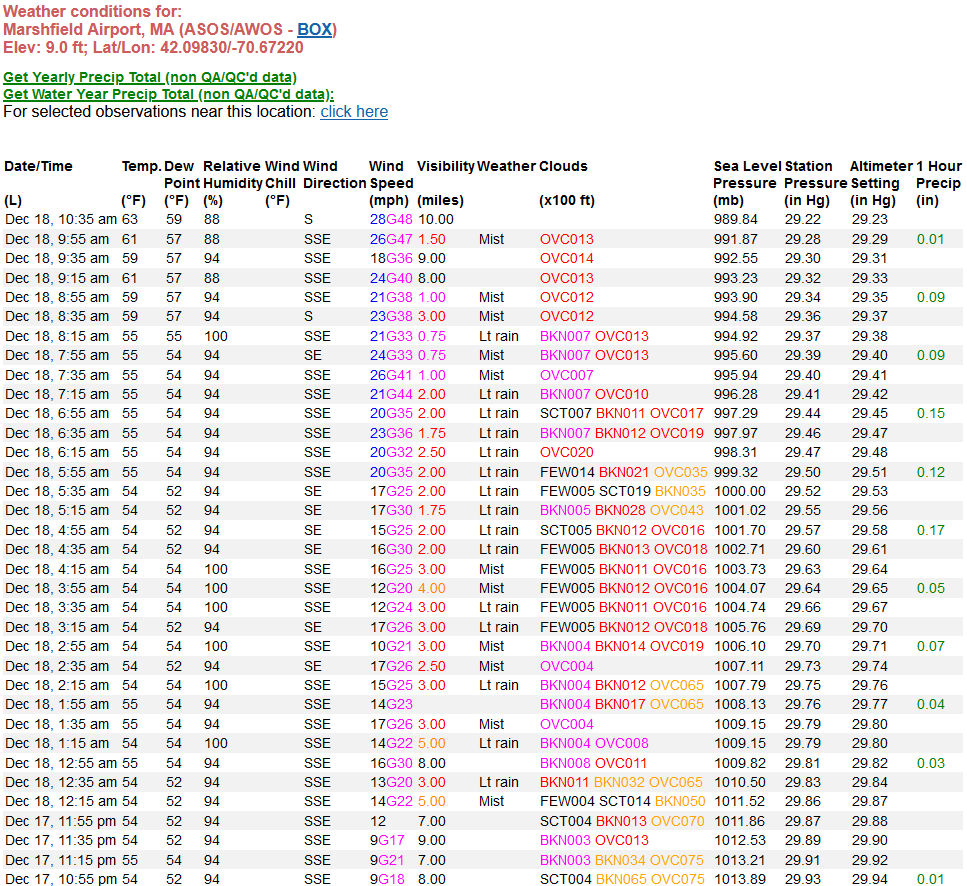
61/59 at the Oxbow site ( about 2.5 mi as the crow flies from here). Max wind 27 mph gust, so far. 2.20"/24hr. That's probably more than less what is expected out this system for this interior region. But I will say ... in the decades of my Met life living between the Waltham/Lowell/Ayer/Acton region, I've see southerly gale December systems that rank way beyond this. I've seen legit 55 mph gusts from these kind of ordeals, a lot of times over years. This is not one of those. This may change over the next 2 or 3 hours ... but looking around area obs ( and I've provided sources to objectively demo this) I don't get the impression that's happening. We'll see. -
Sunday, December 17 - Monday, December 18, 2023 Storm
Typhoon Tip replied to weatherwiz's topic in New England
Dry slot brightening is moving swiftly N ... NY area/western LI appear to be 'bacon' now ('BKN' ) when observing hi res vis satellite this hour, and it's about to enter S. CT. -
Ah, unfoooortunately ... there is a kernel of value to his/her post, though. (firstly, there may be a history between that particular poster vs the consensus that I don't wish to broach, so tfwiw) All forecast efforts should be evaluated. No issue with that nested sentiment. If a trend of failure is/or can be objectively proven to be so, stop whatever philosophy that is being used in the materialization of the forecasting. That's just good science. I didn't read anything particularly sloppy - like 'not lucid' - nor personally attacking but again, if there is some 'greasy' history to that where I'm not aware, oh well -
-
Sunday, December 17 - Monday, December 18, 2023 Storm
Typhoon Tip replied to weatherwiz's topic in New England
"environmental woke-ism" has ruined those types of walls for me. I used to think they were aesthetically pleasing ... but now? Every time I see them they just look like big plastic artificial poison. I mean at least the plastic in the Pacific ocean can perhaps be remediated but what's going to happen with those big sheets of the shit erected in bulk. We're deliberately creating a disposal problem for future generations - right? And what is the 'micro-plastic' mass they are contributing. Not sure with all the shit that's being exposed about the plastics industry and the toxification that's materializing/caused by it: why is the practice of deliberately creating bulk tonnage of the stuff even allowed. But ... if that stuff is not part of all that concern, fine - -
Sunday, December 17 - Monday, December 18, 2023 Storm
Typhoon Tip replied to weatherwiz's topic in New England
Yeah, so far this appears to be a "standard" sort of wind event - fitting into climatology for these southerly Dec gales. GRR's obs site density isn't too bad, https://www.wrh.noaa.gov/map/?obs=true&wfo=grr Not sure if these are "official" per se, but they are carried by NWS so -