Typhoon Tip
-
Posts
43,386 -
Joined
-
Last visited
Content Type
Profiles
Blogs
Forums
American Weather
Media Demo
Store
Gallery
Everything posted by Typhoon Tip
-
It’s just continuing along the same tortured slow creeping trend of the last two days …
-
GFS still trying for the 30th
-
That’s an exotically negative NOA … not sure what the problem with that is.
-
If we could just get rid of this piece of shit we might actually have a chance at a rain --> snow NJ model deepener out of next week.
-
Occasional Thoughts on Climate Change
Typhoon Tip replied to donsutherland1's topic in Climate Change
It's why I am really not completely amazed at this December so far over on this side of the N/Hemisphere. If the scale and degree of the U.S. and N/A mid latitude temperature anomalies were taking place everywhere? That would be huge problem like right now - not in 50 or 100 or whatever years. NOW. I don't really trust CNN for science news reprint efforts. I do trust Phys.org - they do a marvelous job at paraphrasing hard science papers right of the submission acceptances. No doctoring through an interpretation mill - or if one doesn't trust that is the case, they always supply a link/referral to the source so you can read it, thesaurus in tow, for yourself The hemisphere is warming, though. This doesn't let the issue/crisis off the hook. You may have just meant that in rhetoric jest but ... we're not really balancing because it's cold over Eurasia. What we can and probably should be doing, is determining December's temperature average all over the N/Hemisphere (everywhere). It is likely above normal. Therefore, not balancing. -
It better snow when it can or else - ...actually, I suspect the warm bias in the east and especially the NE has in part to do with the fact that like the polar regions ( relatively speaking ...) we have more room to rise than the west coast. Doesn't explain the Dakotas very well but that's why I say 'in part' ... Think of it as 'trough cold' is less. Florida and south TX warming is interesting too -
-
Jesus ...where the hell was I. Were these like one-and-done winters? I don't honesty recall those storms - maybe they just were unremarkable where I am.
-
Mm... suspect the patience for hearing any of this is growing thinner with each passing week of having to wait but, that's a pretty cold signal - relative to latitude-based climatology, wise asses .. Formulating into a higher degree of meridian flow in the hemisphere look through the first week of January - on all three ensemble means. ( I'm only bothering to mention it because in this malaise of 'been there done that' hand throwing, I suspect a fairly high probability that people have stopped looking lol ) But, the above is showing up now in the numerical telecon projections, with an EPO mode flipping into negative after Dec 30 - it is likely the meridian flow type is now invading the EPO region enough that the EO functions are being numerically forced ( that oughta ache-up some heads nicely haha) I've been monitoring it and lower EPO index has been increasingly so (2nd derivative). Not only that, the distant GEF and GEPs West Pacific Oscillation projections have that index neutralizing, with most of the spread on the low side. What is interesting about both the EPO and WPO, these so-called "control runs" ( I assume by that they mean, 'call Kevin and ask him what he wants and then the initialize the models to force a sexier solution') are all below the trend line of these index forecast out in time. So ...whatever that's good for. I think the WPO is important as time relentlessly delivers us deeper into the next month (whether we want to or not...). -WPO sets the table for more MJO phase spaces that actually constructively interfere with the ENSO base. Sweet! For winter storm enthusiasts... you really want the AB Pacific circulation variant of the warm ENSO forcing. In simple terms ... that would be a meridian conveyor of colder air toward N/A mid latitudes, while the southern stream is moisture jacked. I know people want dates.. but I'm talking "deeper into January" because that's all that can be defined for now. We're not talking about a winter storm here. We're surmising pattern scaffolding.
-
heh ...yet it's the only model demoing any consistency with that whole fracas
-
That oughta set up the mood around here good and proper ... D.C. with a foot of snow in the first week of January
-
I get the sentiment but ... in this case, I think it's a little out of line. Sub 540 dm hydrostats with NW flow preceding and DPs between 12 and 19 the previous afternoon is a legit deep winter air mass. It's just not bone chilling cold or whatever. But it is real and deep and cold.
-
This is a different look compared to prior spreads... The 2 meter 0C isotherm splits the area in half during this means/interval below, too. That's also cooling the column while both surface and aloft collascing on a climate position. Also take not of the 500 mb height changes? It's a situation still in flux to me. The erstwhile +d(PNA) appears to be exerting on the continental super structure in having more weight over the western ridge aspect. This actually helps colder solutions for a couple of reasons -
-
Hmm interesting changes in the GGEM and GFS (oper.) for the 29th/30th It ain't over folks. The debate on whether that interval can turn colder isn't settled yet.
-
Occasional Thoughts on Climate Change
Typhoon Tip replied to donsutherland1's topic in Climate Change
Yeah .. okay, I see what you mean. I was getting at more of a 'primal fear' mechanism for/to elicit change. You know, big gray abyssal wall of sea water coming over the horizon. The 2nd sunset glow from an asteroid impact while the Earth begins to crack and tremble under foot type stuff. Four Horseman rapture. I'm not a religious person in any organized sense of it but ...there's a reason why 'fire and brimstone' works in those passages. That is what is required. Digression ( haha) but you know what the bible really is? It's a historic framework for failing human virtuosity because they are incapable without being directly stimulated to do so. That's all it was, really. Do this or fear God casting you to hell ( so to speak). Well ? Stop profligate consumption of fossil fuels for the purpose of powering the industrial convenience engine, or you'll all burn in hell. Sound familiar. It's not even a metaphor. The principle is identical. Humans need more than videos of famine, or media coverage of heat waves in Asia. They need knocking at their door - in other words, it's always 'somewhere else' In fact, I'm beginning to suspect there's a "warming" (puns are free ) to inaction, because CC doesn't hurt enough, right now. The warnings are getting comfortable to live with in other words. It reminds me a little bit of that passage in the historical account of the great Galveston hurricane disaster that took place in the early years of last century. In "Isaac's Storm" Larson described the sea as rising with successively increasing wave heights. Warm gulf waters were up an over the causeways. But the sun was shining - false state of euphoria supplanted the ominous portents of the tumultuous ocean, because the warm autumn sun, along with the playful surf and light NE trade breezes were too pleasantly immersive. Despite the initial observation of the rising sea, the mood turned to a period of gaiety; the masses wasting precious time that should have been used to leave the barrier islands. Are we in such an interlude? What you describe with 'fear of having to change' is certainly a valid psychology, too. And it absolutely will retard effective action from being implemented with any sense of rapidity.. But, it's a softer variety. It's a part of our interlude. You know what ... all of reality is but an analog engine. We just don't see it because we're too busy separating and categorizing all that we observe into different colors and shapes. But the universe seems to reproduce the same theme via different systems. Think of our current climate crisis as a super massive star, destined to super nova ... Did you know, that it takes ~ 10 hours for the termination shock of the initial super nova event to even surface the star from its ignition point in the center? For 10 hours, the star shines in it's immense glory, just as as it always had across it's millions of years of existence. The surface ... utterly oblivious to the fact that it's already dead. Much like our interlude, we may be in our 10 hours. Circumstantial analog to the star. -
Y'all's talking past one another. He's making the point that if one is engaged in this social media/hobby for winter enthusiasm, +10 up there isn't a death knell. You're making a point that there is something afoot that is far more unusual - or seem to be ? - than merely qualitative analysis over temperature anomaly distribution. You're points are two different discussions.
-
Time is the crucible in which we burn - it's always been about the amount of time of exposure. Pollution in urban areas is every breath in perpetuity. Smoking is a Darwin Award looking for a celebration, but when you are not smoking ... you may not necessarily be breathing bad air otherwise.
-
Frustrating run overall, tho ... Probably better that the greatest common denominator heads in here didn't see it.
-
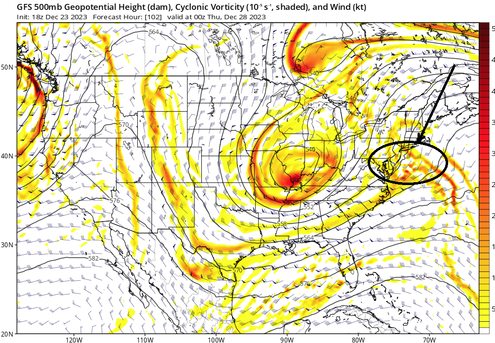
`Correction vector' is pointed toward more amplitude between ...really Xmas and Jan 3 ..4 What's going on in both the operational Euro and GFS is a 4 or 5 day maelstrom of negative wave interference. I've lost count how many S/W jet torpedoes in that whirling mess that would have enough to get a winter shot in here. I think we should bide time on the whole period.
-
It makes me grin a little at one corner of the mouth when read the content in here sometimes. Little like post mortem emotional recovery. This is the "bargaining" phase. lol The other aspect ( other than that 5th grade approach) it seems there's a lack of imagination? I mean "appropriate imagination" Anyone can imagine a 13 isobar black hole parked 20 min SE of Block Island. We mean imagining ways that could manifest and turn things for the better. It's a not a knock. Not everyone can envision those 'plausible' changes ... There are times when I'm looking over the product suites and think, 'Yeah but this is really not as bad as all that because x-y-z' Come here and the 'Book Of Eli' would be a utopian alternative. It's like, on the charts or its the tragedy of a flopping 6-year old told the word no.
-
PNA is a lot more than neutral from all three accessible agencies -
-
You and I may be the only two individuals in this engagement of returning users that is willing to suspect ( if not anticipate) another 80 F temperature event in February. I've seen this occur twice in 7 years, with a few other occurrences of at least 70 during Februaries over the last 10 years. I also count the 86F heat in March back in 2017 as likely connected to the same sort of stuff/forcing. Whether it snows in those FMA months is ultimately 'sides the point, there is an interesting signal there happening regardless - which has also taken place regardless of ENSO this or that. I don't have a problem with late Jan version of that - ... may not be 80 ( lol ) but 70. I could see that happening. Especially if we make it that far without a cryosphere over southern Canada. By then ... we are only two weeks from exiting the annual solar minimum period. It may be fun to yank the short and curlies of the winter enthusiasts with sobering aspects - that's not what I am trying to contribute to, here. seriously! but I wonder about NH heat this next warm season.
-
yeah ... it's interesting. i've noticed that. there are signals in conflict from multiple sources. for ex, the NAO is positive (very much so). it is slowly dwindling down to neutral by the end of week 2 but in so far as what it properly should interpret, that is no help for winter enthusiasts through that period in question. positive NAO modes support the left turning storm tracks through the Lakes. in contrast, PNA is hugely rsing. +delta to +3 SD. a positive PNA state in latter D thru JF connotes a western ridge/eastern trough PNAP response. doing so clear to +3 standard deviation? that's too much in an index that covers a domain nearly a quarter of the planetary x-y coordinates to believe the western ridge/eastern trough PNAP response would ultimately fail. we are seeing that, but what comes next is oddly empty. it's annoying. getting tired of looking at it and making excuses for why the table is getting set with fine china and stem ware, yet the operational versions won't deliver guests to the gala. the charts should be lit up with a something ... i hate to say, but the Euro solution from 00z ... ( even the fantasy range off the 06z) are not terrible statistically fits for this PNA era extending into the first week of January. lacking cold air for the 29th thing but most have been on the same page with that.. however, the Euros deep coastal isn't the shared vision. what a range of solutions, huh. Euro coastal menace ( flooding inland, surf damage on the coast, and federal grant to keep the ski industry from a billion dollar collapse), the GFS with a giant busted ravioli of a cyclone that looks more like something out of the pages of an tortured April sog fest, and the GGEM with absolutely nothing. f-up morass in the guidance. all i can say is that statistics support more than the GGEM. that's about it.
-
could be gout ... I used to get that when I drank alcohol and ate meats. It would crop up at weird times and seemed to mimic known things like that. Elbow this, or planter's fascia that... The toe one is easier to identify, but I was runner and thought the first time an episode struck it was turf toe from running miles at the high school track. When I cut out drinking entirely some 7 or 8 years ago - no love loss; don't really miss it - and converted much more daily caloric intake to raw untreated cut fruit and broad spectrum salads with ample bean mixed in, within a year or two the gout was down to one easily Advil - manageable episode every 2 months. Within 3 or 4 years, 6 months. At this point I haven't had one in 3 years. I still eat meats - I just don't go crazy. Just sayn' ... I'm off work through Jan 2nd so expect out of left field boredom post from me. lol
-
Oh, I think it’s even more so than just a month off. This idea of shoulder season winters is gaining traction - turning into a seasonal smear
-
The heat this summer may come to North America