Typhoon Tip
-
Posts
43,367 -
Joined
-
Last visited
Content Type
Profiles
Blogs
Forums
American Weather
Media Demo
Store
Gallery
Everything posted by Typhoon Tip
-
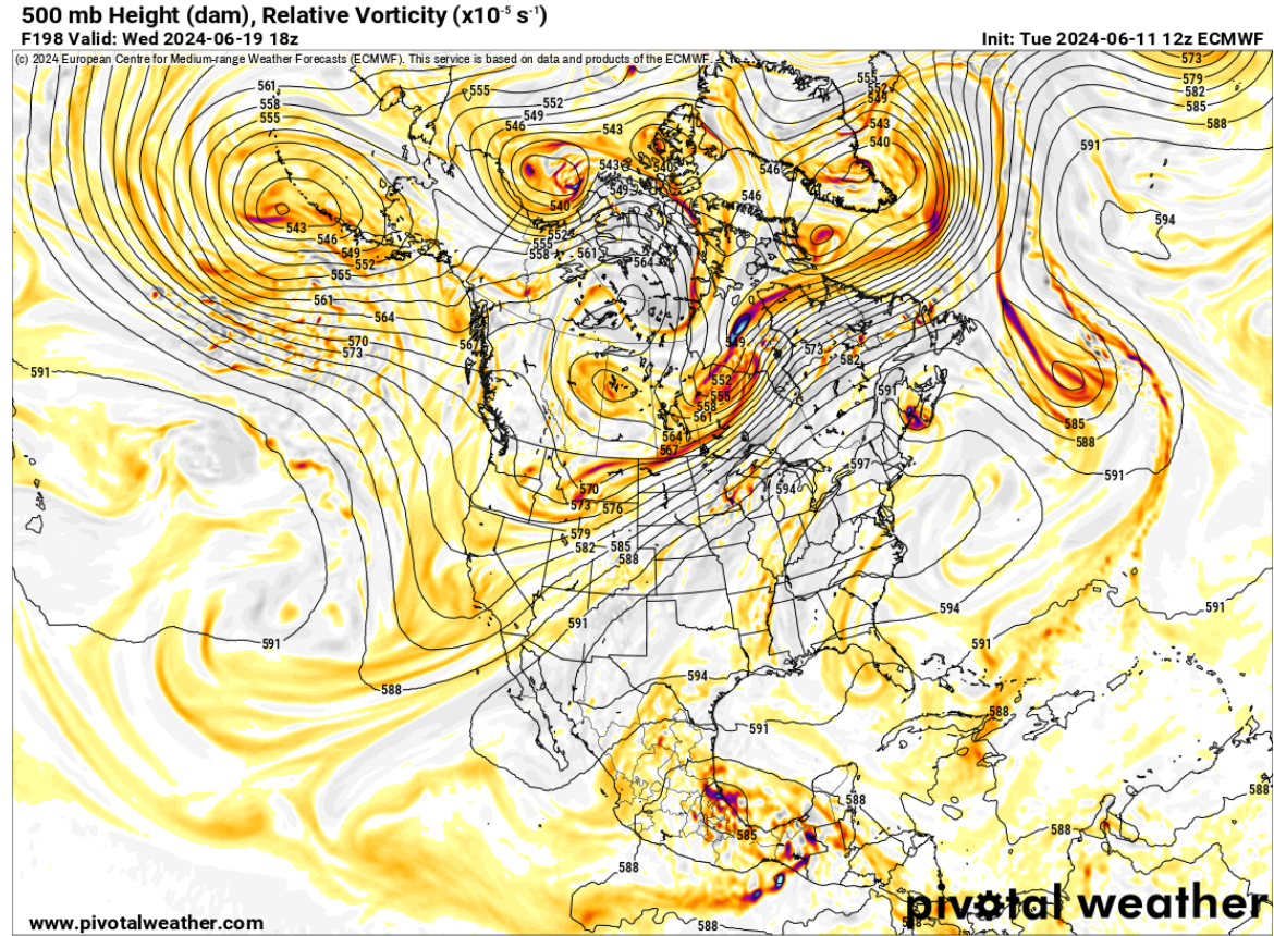
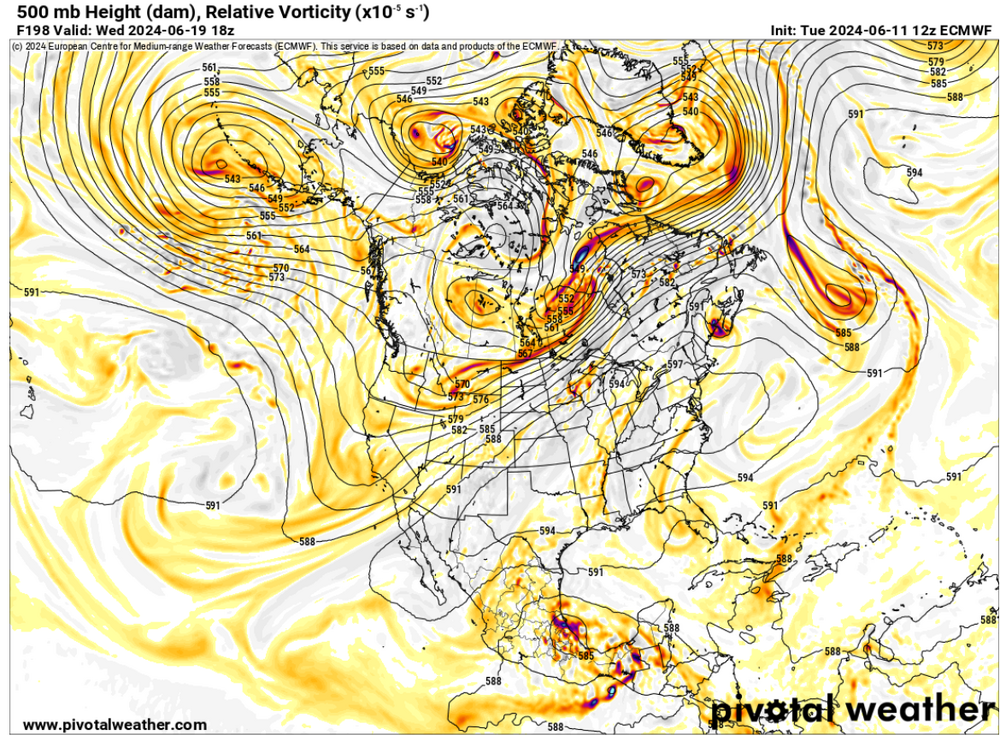
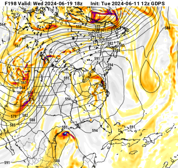
Wow... so yeah...after a relaxation or suggestion of something more seasonal from the 00z, the 12z's are so far all upping the essence again. We seem to be oscillating between above and much above+ with this solstice heat. Check out this sick looking 12z Euro operational - first operational run that begins to explore the upper potential in this modeling saga so far...
-
GGEM has also come back with a bigger signal - in fact, the biggest so far since detection of this began a week ago. Both GEFS and GGEM are also open ended ... They're not indicating a pattern change so much as a deterioration of coherency, while maintaining essence of -PNAP paradigm. If nothing else, it's a pretty impressive extended rang signal - relative to that...
-
Pretty sure he was kidding but to your point ... this Thursday/Friday mid 80s was originally modeled to be the entry days whence about 7 days ago in the early detection. As we've gotten closer, the old can kick. That said, I do think that around Juneteenth ( which happens to be my birthday LOL ) that appears to be a R. wave anchor. Whether the dailies plume the ridge to it's fullest extent remains to be seen, but once it sets in, the GEFs ensemble was multiple days of this look ..through perhaps 300 hours It all smacks as a red flag for potential, the ceiling of which may or may not be reached. These individual operational runs have been fiddling with reasons to lower that but there's no continuity and can't be trusted.
-
Impressive GGEM run re the -PNAP structure. Has a sizeable 594 circumvallate closed off along the EC that extends to BOS latitude embedded in a ... well shit, here That weakness there centered over OH/PA is in fact a remnant tropical inject from off the Gulf ... undoubtedly transporting some serious back of Gulf ball bag steam into an already egregious set up.
-
Yeah, PF and I have broached this subject a few times over the years. There's been this propensity in May's to see ridging evolve between the Del Marva and NS... That's like taking a WAR structure, and then repositioning it N of normal. Some of those early heat pops featured humid SE flow into D.C. and PHL...with S at LGA and BOS being afflicted by SSW which are technically an indirect marine contamination from the S. But DTX-BUF-BTV has a WSW wind around the NW periphery of said ridge. Also, the flora of the continent isn't quite yet dumping evapotranspiration theta-e back into the circulation medium as much in mid May at those latitudes... that plays a roll - dryer air and 'desert' like responses. The result of SSE flow along the coast and WSW flow inland sends BTV to the sunny side of the moon while PHL-NYV-BOS are stunted. The changes in the spring time circulation modes may or may not be a part of the CC stuff - I suspect that's the case because noted mode changes are happening elsewhere around the globe, so in the absence of another explanation. Then later on ... the summer deepens and everyone N-E of the Mason Dixie ends up pretty much in a DP anomaly with comparatively tepid heat - big heat from the west being blocked by a semi permanent mid level weakness/shear axis from ORD, south. In the means ...there's probably exceptions to the rule.
-
solar cover ?
-
Occasional Thoughts on Climate Change
Typhoon Tip replied to donsutherland1's topic in Climate Change
What is hoped and/or thought likely to be gained by needling through a single county records in PA - particular in this question, ...it's significance to global warming/climate change ?? This has been going on for months at this point to no end. What is the point of it? -
See ... case in point. I guarantee you, no one has probably ever factored this into a seasonal forecast - https://phys.org/news/2024-06-discovery-reveals-ocean-algae-unexpectedly.html
-
Exactly. I would only press that we not only can't know "every", it's more apropos to say we know far less than every. That kind of matters, because the size of the uncertainty is proportional to the amount of dumb fuck luck that people take credit for when the dice roll kindly (tongue-in-cheek humor intended there - )
-
More of a personal philosophy but "luck" to me is really just the uncertainty of not knowing what, and perhaps most importantly, how much all the variables are that have input into a given field of observation. If you know all that information ... the outcome becomes academic. So you rolled snake-eyes at Crapse. You got unlucky... However, if you knew what all the variables were/are that effect(ed) the system of dice rolling, uncertainty almost ( but only almost...) vanquishes. Being able to predict the future dice rolled snake-eyes was all but certain. You no longer call that luck. It's a not a knock on anyone. There's ultimately a limit to how much one can ever know. Hell ... photon double slit experiments won't allow you to observe the photons - only something that is like photons, because the mere act of doing so ( spooky ) acts as if the photons know you are looking and then deviate from ever repeating experimental results. ha ha.
-
Heh... wouldn't shock me if the 00z Euro is more correct on that Friday result. we'll see... but I've observed hundreds of those type set ups where the front's dynamics are ripping away and abandoning it, leaving the only triggers to be the vestigial pressure well/convergence along boundary itself. It causes early eruption over N-NE PA/SE NY, and those cells then Pac-man right of the gradient and choke us off. ...and all we get up our way is anvils and light rain. One or two oreographic/terrain CBs west of Concord NH or something...
-
This is probably a bit outer field relative to this discussion stream but ... I've noticed a coherent difference in the behavior of regional flora this spring. Namely ...healthier. Best flowering shrub species year in probably decades frankly, at a regional scale here in the NE. My family in Michigan also reported to me ..well asked me really, what's up with that. I've also noticed a much, much denser airborne and ground deposition of pollen this year than I have anecdotally observed in quite some time. Now, I don't know what is causing that ... but I was toying with the notion that lowering toxic aerosols(...even if the ppu mass was always considered too minor or not ...) might have something to do with it. I haven't noticed much else different other than the sky - which it, too, is a more unadulterated blue... I'm willing, however, to leave that out of the supposition, though, because it's probably impossible to assume/parse out cloud versus particular aerosol contribution to the sky purity. I'm a big fan of cause-and-effect, and I am also quite suspicious of coincidences. Intellectually ...yeah, we have to vet everything through a scientific process that considering the enormous scale of a planetary system, will probably take a long, long time to prove. But my heart of hearts keeps telling me that entire planetary system warm burst, and subsequent hugely proficient floral biology ... might be indirectly/causally related? Just and idea.
-
I don't think these ENSO's are forcing the atmosphere outside of 20 N/S proficiently enough for that - particularly in the summer when the integrated gradients are weak. Weakly hemispheric coupling would likely flop over into the first half of autumn. I suspect this autumn will go like they all have tended to over the last 8 years... some kind of 'smells like snow' cold snap in latter October through early December, which may even support snow in air ... interceded by other times when it's +15 diurnal unbelievablism - we'll blame it on Nina but ... wild variability in autumns has been the new norm regardless of what leading indicators suggested. Then, ... we'll settle off into a wind scarped AN winter with one or two below periods and a lot of tortured events that looked promising on D10's, but failed to pass successfully through this de-amplifier gauntlet of the D6 modeling game ... Either way, if and when the "storms" come ( for lack of better word) it will consummately only be 50 to 70% of the original appeal in terms of actual storming. Next February will have a week in the 80s ... and March will feature a cat paw Nor'easter with snow in the Monads, and while winter enthusiasts cry about it ... PF will choose that moment in time to tell us how the winter up there was surprisingly productive everything considered ( in optimistic tenor). May is obliterated by cold BDs unrelenting... and the summer is a 83/78 "above normal" CC season. ... April's are a piece of shit regardless of what geologic epoch so no need to characterize - Rinse and repeat for the next 10+ years, while adding decimals to temperatures.
-
Signs emerging ( perhaps right on schedule ...) that this may be more of a seasonal warm departure. Period is still the 17th - 22nd. The end is negotiable. It's not very clear at this time that there's a new pattern modulation out there but there are hints of this settling off into a AN/neutral oscillation look, after the initial wave. This is starting to remind me a little of 2018 July, when the modeling began showing the big dawg 590 + heights in a large ridge node, but was missing the key SW heat released air mass injection. We can "home grow" heat just fine, which is what happened then - however, we miss the opportunity to really suffer ( lol ). But that will take the edge/history off the ceiling if/when we don't get the 24C 850 mb pulses involved. The high non-hydrostats will allow multi diurnal thermal aggregation to expand the hydrostatic heights, and you get one of these heat waves that's like 90, 94, 97 because it takes that long at our latitude to "fill" the expansion room. I'm sure less of that makes sense ... but the take away is that the guidance ( ensemble means) are missing some parametrics that would make this remarkable at this time.
-
2018 4th of July weekend not ringin the door bell yet ? lol remember that? 111 at Bedford in the GFS
-
You might just be begging for this in about 9 days . well not 'you' personally. It's just that, when in that moment your struck with a sensation of not being able to get away from it, you submerged in heat in every direction ... how satisfying a gust of cold wind would be right then, yet it's thousands of miles away. Or may as well be... Next week arrangement has the mid troposphere to surface Hades look about it... Like Mt Washington might set a record. Superlatives aside ... I am getting a little concerned that this may be heading toward one of those 'synergistic heat bombs,' like one of those phenomenon world over - we've not had one of those yet. It's when the models and indicators say X happens, but what happens transcends and goes beyond. They are typically not well forecast because the are empirically resulting beyond what they should have. They are still less common than the standard seasonal heat wave. We are obviously far more confident of that arriving, first. However, I don't think it is impossible to get Logan to 100 and freak 8 degrees on a west NW, CC-enraged synergistic heat bomb breeze ... like what happened in London... or the Pac NW ... Or France... these are similar latitude mind you. In fact London is N of Caribou Maine... It's all a matter of synoptic circumstances tapping into this (apparent) non-linear constructive interference phenomenon that's been increasing in frequency. And they really are not modeled well, because it is all based on the interaction of emergence' then 2ndarily constructively interfering... The models don't model that - I don't think D.C. to PWM has had quite the same thing as that, or what these other regions have suffered. It will come home .. it's a matter of when.
-
I don't really get why it bothers anyone in the first place
-
EPS in looking like it's crossing historic threshold
-
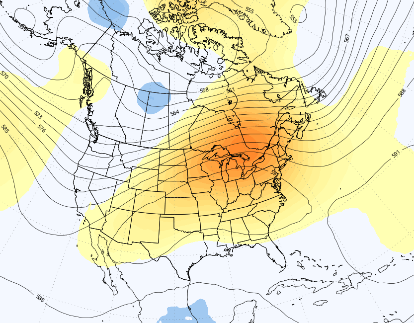
slightly less at 500 mb non hydrostats but it wasn't enough to significantly change the implication comparing the previous the 00z run - not even noticeable. I'm singularly still very impressed that the the 2-meter temps D8-9-10 are 96 to 101 from interior SE NH to NYC. It's hard to get this model to be that warm, at that range.
-
C'mon Jerry. folk assign weather to unresolved internalized nostalgia/issues they need to get back to - it's personal. So much so that even though it isn't really controlling their lives - per se - the weather outside needs to resonate with those sensitivity or does cause them a form of discomfort in the headspace. ha
-
I didn't get the sense that he was calling off anything? It reads like he is conveying the model trends. yeah, he does say that he thinks the Euro will turn out correct, but he also offers uncertainty too, "...possible that the consensus could also be correct" - grammatically redundant but that's no crime. lol
-
two vectors: 1 ... that's the low end of the signal implication here - the totality of which isn't just the scalar telecon numerical values, but 'synergistic' ( complex -) dealing with pattern recognition shit blah blah 2 ... from this range, it's tricky to label amplitude ranges on anything, particularly related to heat. ... heat is the most guidance-fragile of all natural headline threats, where un-model-able cirrus plumes, or the core of the hottest wafting over at 2am ...etc etc, can make the difference between a 104 and 95 ceiling. As an after thought The problem with the ceiling in terms of probability and chasing records is that 99.4 and 99.6 might make the difference between a historic and non-historic day.
-
It's how Gaia gets rid of the problem I've written that in the past, my self, to muse and ponder how humanity cannot seem to see the wild fire through the weeds - but since they created the blaze, it's apropos, perhaps karmic that we "toad" ourselves off the planet. Wouldn't it be interesting if it was all just another way among many in which the planet seems to have a self-correcting mechanism... and we are about to be corrected Only in our conceits we seem to carry on with this quasi notion as though we're not a part of the natural order of this world; we are spectators making interesting observations along the way. We've only created this illusion of proxy over nature, yet are still inexorably connected to its various correcting schemes- It's almost funny ...I like the metaphor of turning up the heat cycle on the oven to 'clean it' too as a different take "Can't see the field through weeds" ... Humans, like all other life on this planet, really respond most proportionately to that which is directly sensible through the five: sight, sound, hearing, touch and taste. If advice does not immediately appeal to at least one of thase, to wit climate change does not appeal to any of them spanning daily existential life, the "risk" isn't perceivable. Thus, designated for philosophy rather than action. That is the metaphor to the toad's oblivion. What's fascinating about that ... humans are the most intellectually capable of predicting the future as a series of related consequences - it seems there's a war being waged between that evolutionary advantage, and the evolutionary advantage of innovation - which got us macro profligate 'entitlement' to resource using Industrial mechanized piggery. haha
-
Boom! You may recall, you and I lamented this probability about 9 days ago. I distinctly remember writing one of my patented tl;dr to make what is actually just a small point ... how '..It probably won't be as cold as that looks when it verifies' - or phrase to that affect. I think you replied, '...yeah I doubt it actually gets as cold as that looks and we'll find a way to somehow be above normal anyway' Not sure what the significance about the above paragraphs is oh yeah, I was going say, it seems this is more dependable now than folks are aware? Even the cold snaps in winter get shirked by 4 to 7 worth... and the nominal "between pattern temperature" seems to always just base around 1C above normal
-
and it has nothing to do with climate change, either. ...amazing