

Typhoon Tip
-
Posts
43,366 -
Joined
-
Last visited
Content Type
Profiles
Blogs
Forums
American Weather
Media Demo
Store
Gallery
Everything posted by Typhoon Tip
-
I wouldn't be shocked if there was an earlier onset of some color among various species. I few years ago ...I wanna say 2019, but it may have 2021 ... some of the maples around this region of Rt 2 in SNE appeared to go 3 weeks early. I noticed also, these color changes were abnormal. I'm just excruciating enough to remember particular trees' color hues. You know? this one is tends to saffron. This guy's yellow... This one's red... etc... These were all flushing yellow or biasing more yellow than normal. I thought maybe smoke had something to do with it ... but, I read a paper ( which I've lost ref too - ) that suggested not only was this noticed in general, they cited overly proficient growth factoring was the cause. Basically, it takes a certain amount of carbon-based chemistries, plus energy in some sort of ratio in order to succeed both growth and then sustaining the different yellow, red and green colors. Once that is used up, those breaks down - I'm butchering this, no doubt - and drains back from the leafs exposing those that require less to maintain.... We also had a blight couple of years in there, where not only did this yellowing occur early, but there were those shit stains all over them. But that's the warm steamy back of rancid sack DP thing and a different issue. Anyway, this year's warmth overall and much more abundant sun, and a wet spring... etc... this seems like a candidate year to test that idea above. Granted some are dry in the back yards coming down the stretch here but at a larger regional scope the U.S. drought survey isn't too impressed with any status of dry this season. They do target Brian though ...which is interesting haha
-
It'll be interesting to see what happens in this Aug 7 to 15th time span with temperatures. Just using experience with the amp bias, and applying it to the various depictions, it seems an ~ 15 to 20% normalization off that crazed higher latitude meridian flow anomaly likely limits the actual "cool" value to whatever gets delivered. Another aspect I am noticing about that whole period of time is that the spatial layout of the amplifying pattern is situated above the 40th parallel. Pretty strong operational coherency for the expansion of the Hadley cell summer. If we shave 15% off the model amplitude, and consider that N bias in the termination of the westerlies, that also tends to mitigate cooling some. I dunno... it seems in an era when we are either always AN, or ... finding least excuse imagined to make a BN outlook more average, maybe we can start to identify how and why-for the error.
-
-
I wonder if the water cooler conversations down at NCEP ... CPC ..etc, ever include topic surrounding any kind of awareness that all model products, from ensemble derivatives to straight up operational version depictions, appear to be overly amplified by a variable percentage ( but always over the top ) in the D6 -14 range. Or are they like these MLB nerds ( also ruining baseball - ) heh slaved to the conclusions that spit out of statistical algorithms.
-
Just reminding ... as the product header indicates, those CPC day 6-10 and day 8 to 14 temperature probabilities are only for the direction of the departure, plus or minus. Says nothing about how far For example, suppose there is a 90% chance of above normal ( huge value on that chart ...) over some region, and that region ended up .0001 on the plus side, vs another region that is just 30% ( modest value on that chart ...) and that region came in +5 ... 90% was not wrong. just sayn'
-
Heat advisories should be posted from noon thru 5pm tomorrow
-
https://phys.org/news/2024-07-climate-fast-havent-bad-extreme.html
-
NAM’s keeps getting hotter and hotter for Thurs
-
Yeah it strikes me as unlucky
-
Tomorrow looks like a low LCL masterpiece. Convective enthusiasts cringe at the lack of deeper layer kinematics?
-
yup.... I think it will be a fantastic opportunity to explore the edge of reality, whence the as of yet spontaneity of emergent processes ( i.e., 'chaos') that attempt to alter the future, have not occurred along the linearity of common time experience. That's a wild, wild implication that "precipitates" ( haha) out of quantum computing. We were always taught that model-based weather forecasting had ultimate limitations, utilizing the transistor base computation - but that was based upon being (admittedly) blind to the quantum realm. That was just 20 some years ago ... It's like "humanity won't fly" type stuff ... This QC shit is really even beyond that, tho, if you ask me. It's one thing to be able to "sense" flight because you just need wings. But being able to read the mind of god ( taking a little sci fi poetry license there ) is bit of an upgrade. Heh
-
Despite the sometimes dazzling display of AI it is important to remember, the technology is primitive. It might be hard to think of it that way when it's mere maiden release might already seem " ... indistinguishable from magic" ( Arthur C. Clarke ), but it's true. It has to be. Purely by convention of time, it's been talked about for over a decade, but it's only been 2 or so years since its arrival, and so, so fast, already being entrusted/incorporated. So I agree with Brian largely here that we'll be giving it a chance whether we choose to or not. In part because it really will become 'magical' - for lack of better word. The obvious, logical evolution will see it wired into this new Quantum Computing technology. That will be like AI the firecracker, vs Hiroshima QC will be truly, truly be transformative. Think of it this way. The present day mode of computation is performed via transistor tech, which ultimately is constrained by executing 1 or 0. On vs Off... True vs False. Every possible solution that may describe a system, thus has to be solved, one at a time. Granted, doing so at dizzying speeds ( of course! ), but we're still sending electrons along prescribed (fixed) circuiting routes, where there is all kinds of limitations related to ohm resistance, to signal degradation, ... interference - talk to IBM. But look out! QC encodes instructions in the momentum of electrons, themselves... There are no such constraints. Suddenly, 1 vs 0 becomes all possible variances that can exist, that can possibly describe an answer for a question/system/problem, in any facet of nature, explored and bottle-necked to the one remaining truth, all happening instantly. There are many problems that present day tech will never ever be able to ultimately solve. Those become rudimentary for QC. One might find it just as academic to assume that whatever that means for the future of everyday experience, no one has yet foreseen it. But, before even getting to that ( not so far off as we may think ...) future whence AI, slaved to QC "brains" ... imposes its will, even in this primitive form, AI is not going away. That ship's left on this thing when so many different applications are showing whopper quantifiable positives. I am sure we are no exceptions to any rule over here... be we are already downloading SW code solutions that are beta-satisfactory virtually out-of-box. SDLC that would quite normally take even rock star engineers the perfunctory 10 days due to collaboration//resource constraints between man and machine to SQA to blah blah blah. The entire life cycle, beta compiled inside of an hour. 10 days 1 hour And, even if only 20 or 30% error tolerance is allowed, we are finding that most if not all of that error was for 'how GPT was engaged' in the first place - perhaps an art emerges there. New job, "GPT configuration engineering" ? The point is, innovation is already [probably] getting a steroid injection to the point where it's cogs are too deeply embedded in the machinery of society. Giving this some relevance to this social media ... guess what this means for weather forecasting? Guess what it means for the entire engagement. There will be no point in waiting for model output and the fun of discussion. Lol... you know, we forget that 98 some odd % of walking talking civility is happy about that.
-
Almost looks like positioning a synergistic u/a warm event over the actual pole
-
Occasional Thoughts on Climate Change
Typhoon Tip replied to donsutherland1's topic in Climate Change
The impetus here is that you are an outlier mentality, one that most either have, or are, tiring to engage with, because frankly ... you do not seem to resonate with logic nor sound reason. Your point and approach perspectives to data handling and sources, and how it fits the the broader reality, are less than adequate. Look up cherry picking... you come across as a cherry picker, looking to support a narrative more so than researching truth. However, because it's isolating, and doesn't fit objective reality, you're losing/lost your audience. With all do politeness. -
Occasional Thoughts on Climate Change
Typhoon Tip replied to donsutherland1's topic in Climate Change
No one is really engaging in that thread, however, and so not liking that ... "the person" has wondered back here to resume. LOL -
Occasional Thoughts on Climate Change
Typhoon Tip replied to donsutherland1's topic in Climate Change
This is a fascinating paraphrase/redraft https://phys.org/news/2024-07-net-effects-nitrogen-attenuate-global.html I find this statement somewhat ominous, "...Without man-made nitrogen input, the climate would have heated up even more..." The world just bore witness to a 'global thermal flash' during the spring of 2023. There were zero antecedent indicators predicting that would occur. Since then, there is a growing consilience that The International Maritime Organization's mandated reduction of 3.5% to .5% from combustion fuel in international logistics, though obviously a well-intended pollution mitigation, may have unexpectedly led to the cause. In NASA/Tianle Yuan's paper it is cited that it may have "...Created an inadvertent geoengineering termination shock with global impact,..." Now, from an involving unrelated research effort ( above), science surfaces that relates a complex adding and subtracting physical machinery where various volatile Nitrogen compounds are also quite capable of similar factorization - ultimately summing/resulting to a cooling effect. As an aside, ... I think it is just as important that humanity considers what it means to attempt abrupt "de" corruption of any system that is either already compensating, or has those as emergent properties in the background - if only plausible yet unknown. Think alcoholic in detox syndrome. It would be ( perhaps science fiction visionary - ) a striking irony if a sudden abeyance of anothropogenic forcing were to trigger some sort of out of control cooling. It can almost be easily visualized as napkin arithmetic. Pretend for a moment that C02 scrubbing gets a huge technological advance when quantum computing core, and AI, come to [ the inevitable btw ] nexus. Then what are we left with? Sulfur and Nitrogen management that was mishandled - just like that sulfur reduction act led to the spike. We didn't ask the Oracle that question, we only asked it how to remove the C02 NOW. Wow, what a cluster. I keep coming back to the statement by "WOPR," moments after that other kind of mankind -induced holocaust was narily averted, "... Strange game. The only winning move is, not to play" -
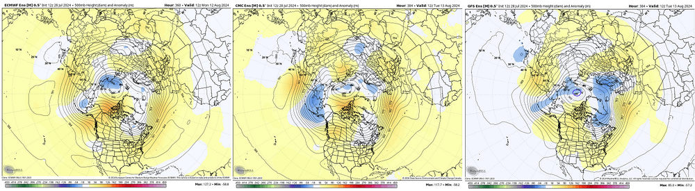
Right on schedule ... does this every year about a month past the solstice ... It's the same thing going the other direction in late April. The front side of summer the model behaves as though spending the two week's worth of frames trying to scrub the added seasonal warmth out of the atmosphere - like ... I dunno, the sun must be an error? About mid way through summer it starts hurrying autumn onto the scene. I noticed it begin doing this about 7 or 8 years ago. Not sure why it does this, but I suspect it is related to why it is always the cooler of the three model systems, GGEM, EPS ...etc. By D4 or 5 it's around 1 to 2 ( almost imperceptibly so ...) cooler with these non-hydrostats below, on the polar side of the ambient jet, and from there it ends up around D12 sometimes 10 colder within the SPVs and general PV well. Euro cluster left, GGEM middle... GEFs mean is on the right. You can see just eye-ball test-wise that we are integrating a cooler PV template at the far end of the model run Summer's not the best season to point this out, but there is slightly more cold in the GEFs there above. - but it begins effecting pattern morphology sooner then 300 hours, particularly so during the winter. If we make this comparison on January 15 it's a bit more noticeable. Winter probably gives some sort of harmonic feed-back between the model's gradient production, on top of the fact that we are in faster velocity soaked state of winters already, anyway, due to the big C-squared. The GFS just has a speed bias man, one which really should be there if there is even modestly too much gradient between 70N and 30N around the globe - creating a surplus cool height on the polar side of the ambient jet seeds that circumstance. No one's seeing it ( maybe?) because we're setting air-land speed records with intercontinental flights and observing 200mph jet cores as it is. Which I wonder if that circumstance is masking matters... Or perhaps even an emergent error quotient because the model tech, despite advances, is up against it when balloons go around the globe at 1/3 the speed of sound in the winter... i.e. fast is error prone
-
Occasional Thoughts on Climate Change
Typhoon Tip replied to donsutherland1's topic in Climate Change
What most know to be true already but yup - https://www.science.org/doi/10.1126/science.adp0212 -
things are on par in the tropics right now. god lol
-
It’s an unusual behavior actually, relative to 500mb summer climo. That aspect’s under the radar. Its a February ‘hook in latter’ weird
-
Yeah I was just gonna say ... we've had some other gems this summer ( definitely more than that abysmal summer, last year..) but this is right up there with the very best.
-
Not sure if this was mentioned but Monday was the new 'hottest Earth day' ever measured/calculated continuing along a string of such days. ( https://phys.org/news/2024-07-monday-warmest-day-earth-scientists.html )
-
That cut off low looks worse than it really is… I mean it’s only about 582 at nadir and because it’s happening at a very elevated ambient height field. In fact, that may not even represent below the middle levels and even if it does, it’s probably gonna be more east and south of it 18z gfs looked weaker yet
-
I don’t think we spent any time in the 60s and 70s… We went right from the 50s to the 80s this year Oh… You meant those decades
-
sorta odd looking. models are attempting a warm if not hot lower troposphere during a pattern whose geometric layout/orientation is somewhat inconsistent at a glance. I guess the 850 mb is just warm regardless


