Harry Perry
-
Posts
1,173 -
Joined
-
Last visited
Content Type
Profiles
Blogs
Forums
American Weather
Media Demo
Store
Gallery
Everything posted by Harry Perry
-

Nov 28-30th Post Turkey Day Winter Storm
Harry Perry replied to Chicago Storm's topic in Lakes/Ohio Valley
For real. I’d like to think the overnight shift would come in and hoist a warning for their entire area with the exception of maybe Huron, Tuscola and Sanilac counties. EDIT: Actually after checking over that way, nah.. warning area wide would be wise. 6-8” all the way up to Port Austin. -
Nov 28-30th Post Turkey Day Winter Storm
Harry Perry replied to Chicago Storm's topic in Lakes/Ohio Valley

- 711 replies
-
- 15
-

-

-

-
Nov 28-30th Post Turkey Day Winter Storm
Harry Perry replied to Chicago Storm's topic in Lakes/Ohio Valley
Ensembles have been juiced and most of the short range guidance (18z) is increasing qpf as well. Also trending better for the eastern side of the state. -
Nov 28-30th Post Turkey Day Winter Storm
Harry Perry replied to Chicago Storm's topic in Lakes/Ohio Valley
Must be contagious. First it was GRR for several years, now DTX too. I agree with you 100%. Second busiest holiday travel day in conjunction with 5-8” of snow and 30+ mph winds… just issue the warning. For many it’s the difference between waiting a day or two and just hunkering down vs. in the ditch with a wrecked vehicle or worse. Who cares if the amount of snow doesn’t specifically meet “warning” criteria, it’s irrelevant when it comes to life & safety IMO. -
Nov 28-30th Post Turkey Day Winter Storm
Harry Perry replied to Chicago Storm's topic in Lakes/Ohio Valley
I did read somewhere in one of the previous AFD’s that ratios would be as high as 16-17:1 which would be pretty impressive by November standards. -
Nov 28-30th Post Turkey Day Winter Storm
Harry Perry replied to Chicago Storm's topic in Lakes/Ohio Valley
Ironically enough I was going to mention this myself as well. Definitely some similarities. -
Nov 28-30th Post Turkey Day Winter Storm
Harry Perry replied to Chicago Storm's topic in Lakes/Ohio Valley
Winter storm watch for the entire GRR CWA. Local P&C showing 8” and still snowing by Sunday. Looks like gusty winds in the 30-40 mph range, so blizzard conditions at times. Still some time for the rug to get yanked but I feel pretty confident in a solid 6-10”+ throughout the sub.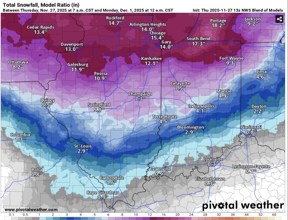
-
Until Saturday. Looks like we’re headed back to the hills with high heat indices for the weekend into the beginning of next week.
-
Generally speaking from heat-waves in the past with dews that high, the temps seem to under-perform a bit around here. Be interesting to see if that will happen this time around, especially after this deluge.
-
Yeah, it’s getting that 06z HRRR messy look. Have a couple of cells that have popped to the SW of here, but they’re behaving. Also another weakening sign, infrequent intra-cloud lightning with soft thunder. Sounds like one of those noise makers for sleeping.
-
We’re on the compression stroke. It’s coming. Heavy sun here and 85°
-
Wouldn’t be surprised by a trim of the northward most ENH based off MOST of the short range guidance. Just looks messy (with some embedded rotating updrafts) Better environment south of the MI/IN/OH border this afternoon.
-
Especially after Friday and we get into the heat-dome with nocturnal MCS. Cue some Johnny C.
-
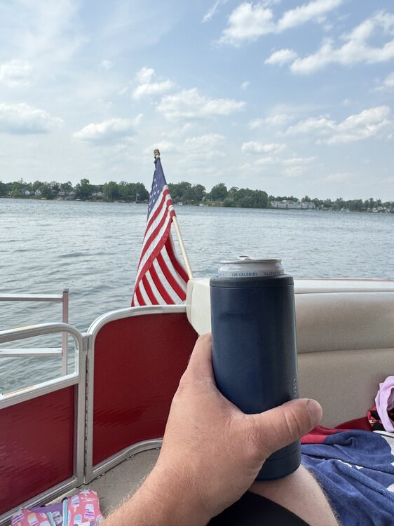
Goguac Lake in Battle Creek. All-sport lake. Good fishing. Little bit of everything and walking distance from home.
-
I don’t know about all of that, but I do know that I’m enjoying one above normal day on the lake today before the weather turns to shit for the rest of the foreseeable future.
-
Frosty start here this morning at 35°. Coldest I remember for the start of met summer. Also see the high temps backed down several degrees for this week. One 80° day looks likely Tuesday now. Should stay pretty comfortable for the first week of June.
-
Spring 2025 Medium/Long Range Discussion
Harry Perry replied to Chicago Storm's topic in Lakes/Ohio Valley
How. The entire state has had SO much rain, especially mid Michigan. The ground is literally saturated. Next weeks “heat-wave” getting shorter and shorter per some guidance. Would end the week into the weekend with mid 50’s, rain and another upper level low lol. Even some Saharan dust (more mud rain). -
This shit is for the birds. Hopefully Memorial Day turns out.
-
Yeah I feel like it’s going to be way more scattered this way. 23z HRRR vs. actual imagery is no where near the same. Everything is further north and south. Granted there will be outflows that will probably blow some storms overhead (which could be more of a bad thing really, just less coverage). There’s a tongue of mid level moisture working in from the southwest right now that might also fire some storms around the Gary/South Bend area, along the LLJ with available cape should blossom, but time will tell.
-
Trends between 20z and 22z would also agree, the tail is further and further north with each run. May end up with nothing here as well. Big bust potential.
-
Not sure if I ever recall this for MBY. Impressive to say the least.
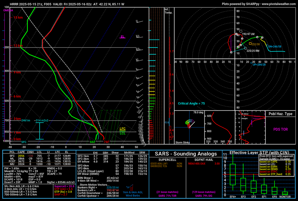
-
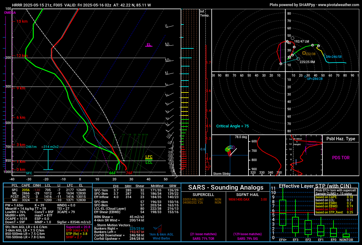
Yikes, going to be a wild ride this evening. Someone’s going to end up with monster hail out of this setup.
-
High-end enhanced. Surprised they didn’t go moderate, but makes sense.
-
Yeah, kinda looks like good bust potential here. If the 12z HRRR comes to fruition, and there is little/no storm action off to the southwest allowing decent venting/tapping warm moist air riding along the tail of trailing convection, there could be a monster sup somewhere in the area. Big IF. But the potential is there.
-
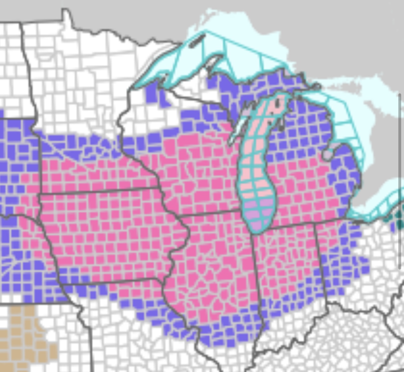
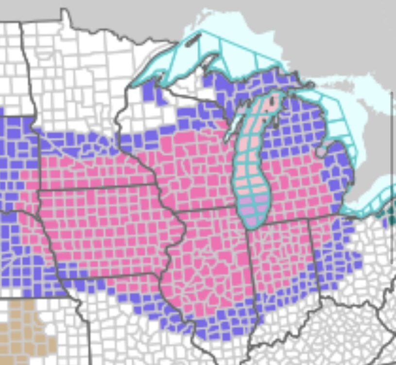
I’d usually complain about this pattern, but we need the rain incredibly bad. This should at least help the southern portion of lower Michigan and much of Indiana and Ohio with drought conditions.