Harry Perry
-
Posts
1,173 -
Joined
-
Last visited
Content Type
Profiles
Blogs
Forums
American Weather
Media Demo
Store
Gallery
Everything posted by Harry Perry
-

Winter 2025-26 Short Range Discussion
Harry Perry replied to SchaumburgStormer's topic in Lakes/Ohio Valley
Make that three! -
Winter 2025-26 Medium/Long Range Discussion
Harry Perry replied to michsnowfreak's topic in Lakes/Ohio Valley
Outside of a couple decent hitters early on, the majority of them were mood flakes to a dusting. It wasn’t all that active in Michigan despite all the talk about it, especially outside of the lake belts. -
Winter 2025-26 Short Range Discussion
Harry Perry replied to SchaumburgStormer's topic in Lakes/Ohio Valley
Less than an inch here. -
Yeah, pretty much emphasizing how severe the storms are expected to be in a given area.
-
Was just looking at that too. Won’t be too bad to remember really. Dashes - going to be hefty. Lines - going to be rowdy. Hatched - Oh shit.
-
It’s coming quick with temps this cold.
-
1/24-1/25 Major Winter Storm - S. IL, IN, and OH
Harry Perry replied to A-L-E-K's topic in Lakes/Ohio Valley
This snow reminded me of the sand in Siesta Key. Impossible to clean up. Like powder sugar. -
1/24-1/25 Major Winter Storm - S. IL, IN, and OH
Harry Perry replied to A-L-E-K's topic in Lakes/Ohio Valley
Storm total just under 3” here. No complaints as it originally looked to be about 200 miles south of here. Happy for the Chicago crew. Even the sun shines on a dogs ass some days. -
1/24-1/25 Major Winter Storm - S. IL, IN, and OH
Harry Perry replied to A-L-E-K's topic in Lakes/Ohio Valley
Sitting just under 2” here. 100% dust. Might squeeze out another dusting to a half inch before all is said and done. -
1/24-1/25 Major Winter Storm - S. IL, IN, and OH
Harry Perry replied to A-L-E-K's topic in Lakes/Ohio Valley
Take it to the bank. -
1/24-1/25 Major Winter Storm - S. IL, IN, and OH
Harry Perry replied to A-L-E-K's topic in Lakes/Ohio Valley
Snow started here in the last half hour. Dusting on everything. 3° with a dewpoint of 0° so I guess you could say it’s pretty humid out. -
1/24-1/25 Major Winter Storm - S. IL, IN, and OH
Harry Perry replied to A-L-E-K's topic in Lakes/Ohio Valley
Brown from IWX must be in here lurking… lol -
1/24-1/25 Major Winter Storm - S. IL, IN, and OH
Harry Perry replied to A-L-E-K's topic in Lakes/Ohio Valley
Hey we still have the new (but old) 00z RRFS on our side…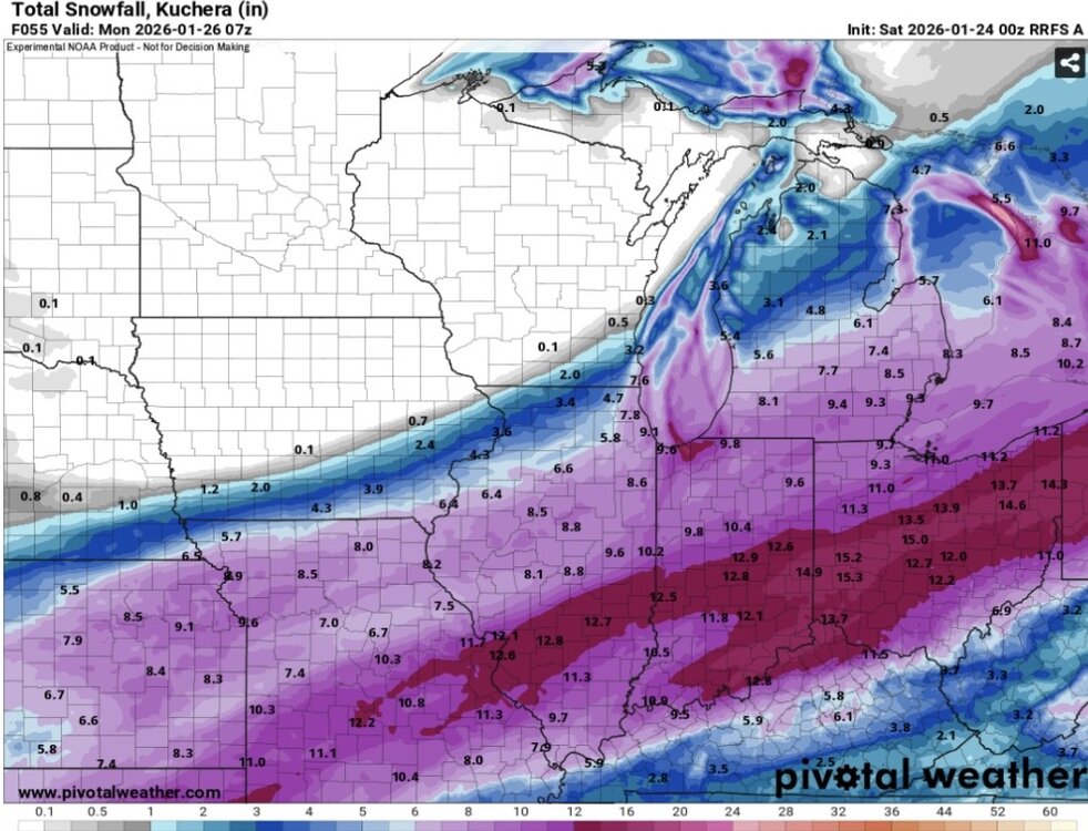
-
1/24-1/25 Major Winter Storm - S. IL, IN, and OH
Harry Perry replied to A-L-E-K's topic in Lakes/Ohio Valley
1-3” call looking money. -
1/24-1/25 Major Winter Storm - S. IL, IN, and OH
Harry Perry replied to A-L-E-K's topic in Lakes/Ohio Valley
It’s not over til it’s over. -
1/24-1/25 Major Winter Storm - S. IL, IN, and OH
Harry Perry replied to A-L-E-K's topic in Lakes/Ohio Valley
00z Euro trending drier on the NW fringes. Precip shield is shrinking. My guess is from the cold. -
1/24-1/25 Major Winter Storm - S. IL, IN, and OH
Harry Perry replied to A-L-E-K's topic in Lakes/Ohio Valley
Also RGEM spitting out 0.4 to 0.6” with 25-30:1 ratios would be pretty damn nice. -
1/24-1/25 Major Winter Storm - S. IL, IN, and OH
Harry Perry replied to A-L-E-K's topic in Lakes/Ohio Valley
Movies nowadays just aren’t the same. Mid 90’s were prime. -
1/24-1/25 Major Winter Storm - S. IL, IN, and OH
Harry Perry replied to A-L-E-K's topic in Lakes/Ohio Valley

-
1/24-1/25 Major Winter Storm - S. IL, IN, and OH
Harry Perry replied to A-L-E-K's topic in Lakes/Ohio Valley
Feeling a solid 1-3” here but it’s way too early to say for sure. That arctic high might eliminate any meaningful snow this far north/west. I’d feel better being south of M59 and East of 23. -
Winter 2025-26 Medium/Long Range Discussion
Harry Perry replied to michsnowfreak's topic in Lakes/Ohio Valley
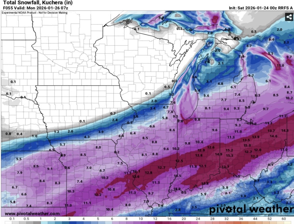
00z Euro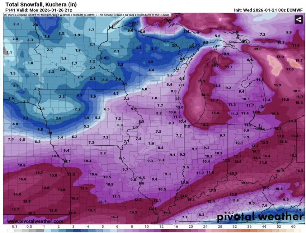
-
Winter 2025-26 Medium/Long Range Discussion
Harry Perry replied to michsnowfreak's topic in Lakes/Ohio Valley
00z Ukie. Some lake effect interference around here but what a mood changer.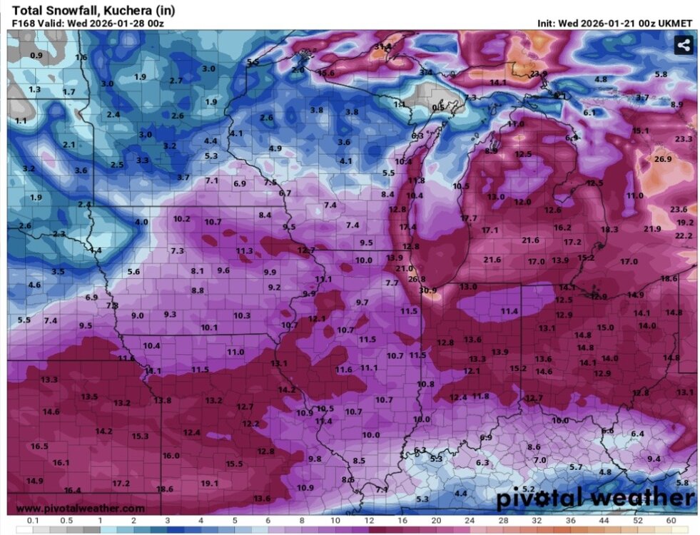
-
Winter 2025-26 Medium/Long Range Discussion
Harry Perry replied to michsnowfreak's topic in Lakes/Ohio Valley
Ironically I was just comparing some 18z and 00z data
-
Winter 2025-26 Medium/Long Range Discussion
Harry Perry replied to michsnowfreak's topic in Lakes/Ohio Valley
Looks like the Hurricane Hunter is going to make a special flight for some data over the Pacific to ingest into the models. Pretty cool.
-
Winter 2025-26 Short Range Discussion
Harry Perry replied to SchaumburgStormer's topic in Lakes/Ohio Valley
My wife just said “This is what happens when the field is mostly men talking about inches - man math.” Ended up with 2.5” here. (An inch or less was expected).