Kevin Reilly
-
Posts
3,419 -
Joined
-
Last visited
Content Type
Profiles
Blogs
Forums
American Weather
Media Demo
Store
Gallery
Everything posted by Kevin Reilly
-
Feb Long Range Discussion (Day 3 and beyond) - MERGED
Kevin Reilly replied to WinterWxLuvr's topic in Mid Atlantic
Clearly showing the blocking NE of Baltimore -
Feb Long Range Discussion (Day 3 and beyond) - MERGED
Kevin Reilly replied to WinterWxLuvr's topic in Mid Atlantic
Here’s are only things we know: 1. The sun angle is increasing every day. 2. We are gaining 1-3 minutes of day light. 3. Ocean water temps are still above normal where they have been for the past 5-10 years. -
Feb Long Range Discussion (Day 3 and beyond) - MERGED
Kevin Reilly replied to WinterWxLuvr's topic in Mid Atlantic
Speed up that 1032 high up north and you got something big -
Feb Long Range Discussion (Day 3 and beyond) - MERGED
Kevin Reilly replied to WinterWxLuvr's topic in Mid Atlantic
Well one thing for sure is from that snowfall map you can see there is a split flow northern branch and southern branch of the jet stream. -
Feb Long Range Discussion (Day 3 and beyond) - MERGED
Kevin Reilly replied to WinterWxLuvr's topic in Mid Atlantic
It's just not that the oceans are warming over time. The largest body of water on Earth is the Pacific Ocean and its warmth is overwhelming the North American climate system. While you have blocking like a -EPO, -AO, -NAO you would think it would be very cold and forcing cold out of Canada, but reality is that we instead get the relative warmth off the Pacific Ocean not allowing the normal cooling effects from land and radiational cooling. Like you said though Arctic ice melt is also probably at play as well and that is melting because the lower latitudes are on fire along with the oceans too. -
Feb Long Range Discussion (Day 3 and beyond) - MERGED
Kevin Reilly replied to WinterWxLuvr's topic in Mid Atlantic
Also to piggy back the Pacific has now ruined our winters now for the past few years with overwhelming our entire North American Continent with relative warmth no matter the state of El Niño or La Niña states. Could it be our warming Earth? Could it be dumping worldwide warmth into our oceans which is changing the overall climate system? It takes longer to warm the oceans and cool them down hence winters in some areas are shorter and shorter windows to produce what we want snow! I have honestly not seen too many times where you have a -epo, -ao, -Nao and can’t find cold air?? Temperature wise we are above normal for January again. Just frustrating to see nothing even in a suppose good look that the Pacific overwhelms anyway. Now that I said all of this it will snow lol? -
Feb Long Range Discussion (Day 3 and beyond) - MERGED
Kevin Reilly replied to WinterWxLuvr's topic in Mid Atlantic
Well we are basically tracking blocking with zero cold air makes you wonder what’s going on? Guess the cold air is on the other side of the poles. -
January Storm Term Threat Discussions (Day 3 - Day 7)
Kevin Reilly replied to WxUSAF's topic in Mid Atlantic
That got “real fast” lol -
E PA/NJ/DE Winter 2020/2021 OBS Thread
Kevin Reilly replied to Rtd208's topic in Philadelphia Region
Only could muster a car topper white Christmas Yay!!! 26 here in Media -
E PA/NJ/DE Winter 2020/2021 OBS Thread
Kevin Reilly replied to Rtd208's topic in Philadelphia Region
Long time!!! Just shows you how negatively tilted that storm got oh what blocking can do!! -
E PA/NJ/DE Winter 2020/2021 OBS Thread
Kevin Reilly replied to Rtd208's topic in Philadelphia Region
Media light rain winds 30-65 mph power outages in the area 1.96” so far 64 -
E PA/NJ/DE Winter 2020/2021 OBS Thread
Kevin Reilly replied to Rtd208's topic in Philadelphia Region
Moderate to heavy rain in Media winds have like vanished weird. -
E PA/NJ/DE Winter 2020/2021 OBS Thread
Kevin Reilly replied to Rtd208's topic in Philadelphia Region
Winds here in Media clicking 50-60 at least power flashes -
E PA/NJ/DE Winter 2020/2021 OBS Thread
Kevin Reilly replied to Rtd208's topic in Philadelphia Region
Think we need this record breaking event outta here before we can see our next snow threat. While the ducks (teleconectors) look just about right I’m not seeing the sustained cold for us to score at this time crazily still looks too progressive. -
E PA/NJ/DE Winter 2020/2021 OBS Thread
Kevin Reilly replied to Rtd208's topic in Philadelphia Region
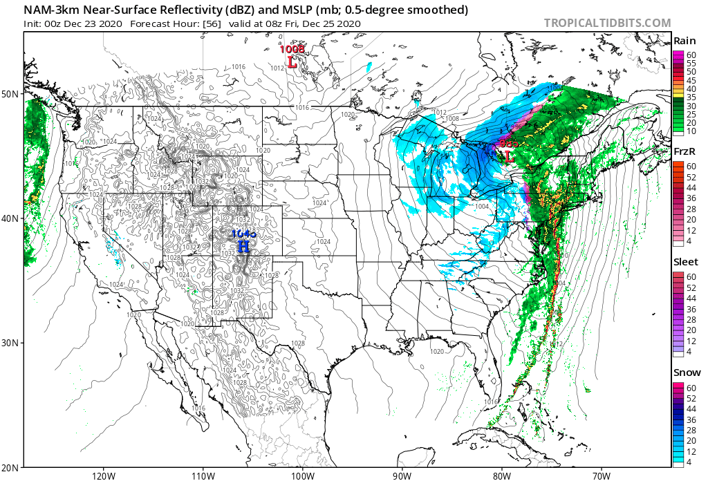
That’s quite a squall line wow!!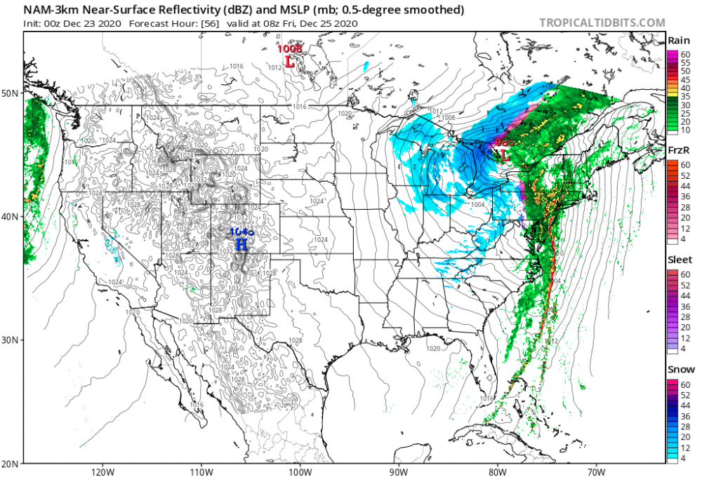
-
Looking at this Eta is definitely on the eastern side of the track and strengthening. I got a friend in Cape Coral told him to batten down the hatches. Naples to Cape Coral Fort Myers up to Sarasota needs to pay very close attention. I would say Tropical Storm Warnings could be replaced by Hurricane warnings at 11 pm.
-
The models have it a weak system that eases out to sea off the Carolina coast.
-
At this point we look for signals but what is a bit troubling not only is the East Coast open to a hurricane strike a major ingredient to this scenario is a blocking high showing up in the Canadian Maritimes and its been there quite a few times now in the long range. I think we need to give it some credibility because up here in the northern latitudes there are definitely hints of changes to a fall like pattern with fairly large mid latitude storms just north of the Canadian border. Here is the system here crashing into extreme northeastern NC Virginia Beach 938-945 mb then to a position over Cheasepeak Bay at 964 mb then to the Eastern Great Lakes. Do I think its overdone maybe but we shall see.
-
Yea here is your next threat September 12th take it with a grain of salt for now, but keep it in the back of your mind.
-
These models are folding their arms and throwing them up in the air and saying there is no way 2 systems can be in the Gulf at the same time and tries seeing which one becomes the dominant feature. Depression 14 right now is getting awfully close to the northern coast of South America and Depression 13 is being sheared pretty good. I see no agreement on models and think the most likely outcome is rapid development right at landfall which in most cases happens in a moments notice without much warning. I’d be prepared in Florida and entire Gulf Coast.
-
95L. Has a vigorous mid level low but low level and mid level lows pretty far apart maybe it can get to the islands and pull an Isaias and relocate its centers. You can clearly see the mid level circulation tuck under the thunderstorms at sun down out there. https://tropicaltidbits.com/sat/satlooper.php?region=95L&product=vis
-
Here’s a question to ponder. How does the Coronavirus affect climate change? The burning of fossil fuels has been dramatically cut since January till today. How will this affect short term weather patterns over the next year or two? Thoughts?
-
Ahhh yes you struck a cord now I remember him you are so right he did!!!
-
-
I post here Im a relative newbie but honestly I like the folk here and are highly knowelegable. Irishbri and Tombo brought me in here to read posts but frankly those that are still here I enjoy reading with and experiencing weather with and are somewhat in the local ball park with me geographically. Ie hey Redsky tremendous thunderstorm line just rolled through me and Kamu get ready!! Also love reading Rays post Famaritin he keeps the snow weenie in me grounded. I vote to keep things as is. I will certainly be here to support and read the fine ladies and gents here respectully. I have learned to keep all views and to listen to other weather enthusiasts lesson learned from Tombo.