Kevin Reilly
-
Posts
3,090 -
Joined
-
Last visited
Content Type
Profiles
Blogs
Forums
American Weather
Media Demo
Store
Gallery
Everything posted by Kevin Reilly
-
brighter blue south of DCA is fronto forcing… north of DCA is likely your overrunning which gfs always has a hard time with. I suppose subsidence could be an issue between bands but that like the other things noted above is now casting stuff.
-

1/6 snowstorm - nuisance event or something bigger?
Kevin Reilly replied to LVblizzard's topic in Philadelphia Region
It’s all keeping it very interesting at least. Let’s just say this wasn’t really happening lately. -
1/6 snowstorm - nuisance event or something bigger?
Kevin Reilly replied to LVblizzard's topic in Philadelphia Region
Yep liquid available
-
1/6 snowstorm - nuisance event or something bigger?
Kevin Reilly replied to LVblizzard's topic in Philadelphia Region
18z Nam changes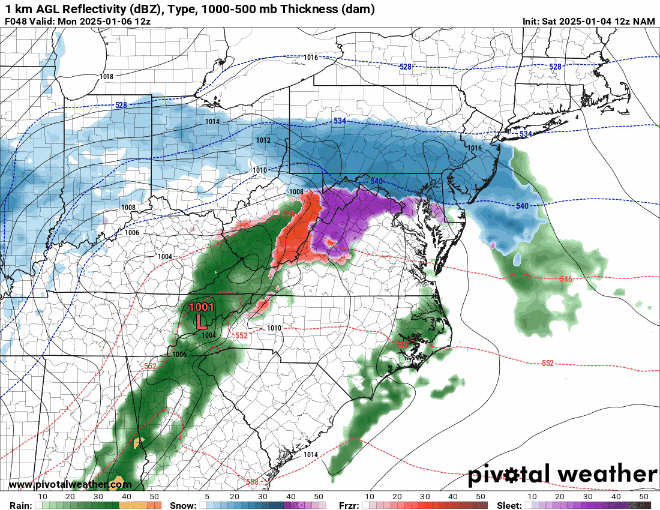
-
confluence is clearly up here weakening and leaving stage right to my NNE over to Long Beach Island NJ.... The winds here in Media Delaware County were gusting past 40 mph about an hour ago and now have dramatically diminished.
-
1/6 snowstorm - nuisance event or something bigger?
Kevin Reilly replied to LVblizzard's topic in Philadelphia Region
HRRR the “Farmers Almanac” does have support from the NBM and SREF lol FWIW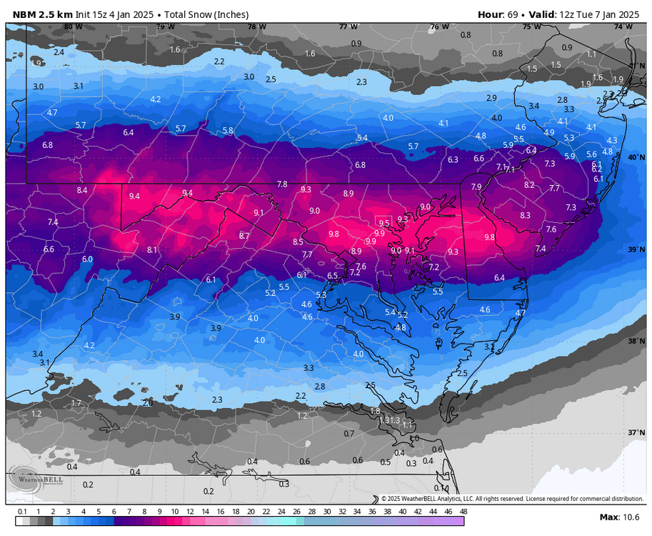
-
1/6 snowstorm - nuisance event or something bigger?
Kevin Reilly replied to LVblizzard's topic in Philadelphia Region
Now that's funny!! -
1/6 snowstorm - nuisance event or something bigger?
Kevin Reilly replied to LVblizzard's topic in Philadelphia Region
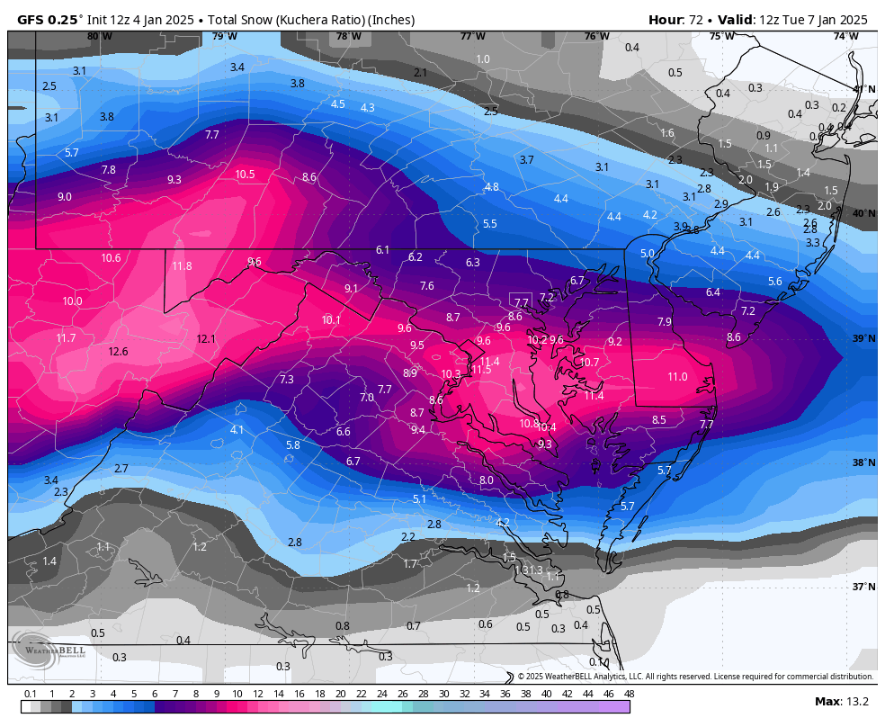
Very happy!!! I am so glad that DT put that 3" snowfall map out for Delaware County! Thank you! -
1/6 snowstorm - nuisance event or something bigger?
Kevin Reilly replied to LVblizzard's topic in Philadelphia Region
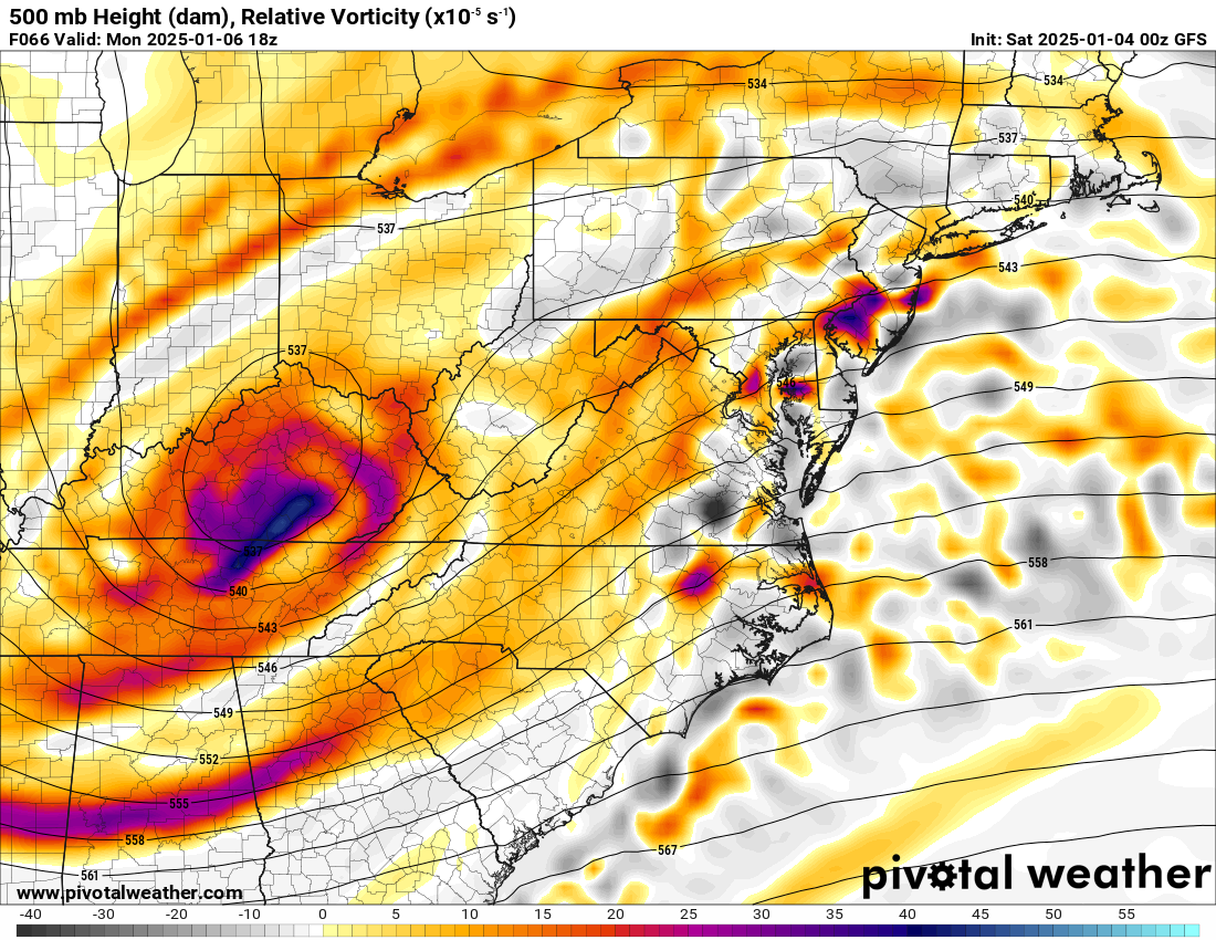
I sure hope the other models follow suit! Let's do this!!! The north trend has commenced, and the confluence is leaving Quakertown to Langhorne, PA to Long Beach Island NJ off to the NE. -
1/6 snowstorm - nuisance event or something bigger?
Kevin Reilly replied to LVblizzard's topic in Philadelphia Region
I am sure it shows 1-3" down here in Delaware County which at this time will not be far off outside of cold snow ratios that we don't know about yet. -
1/6 snowstorm - nuisance event or something bigger?
Kevin Reilly replied to LVblizzard's topic in Philadelphia Region
Currently 31f Looks like on the water vapor map the confluence is now slowly pulling away to the northeast. Looks like the back edge of that very strong confluence is lifting ne in a line from Pottstown over to say Langhorne, PA. I will notice here that the winds have died down dramatically here in Media last 30 minutes or so we are no longer getting those strong gusts past 30-35 mph now. -
E PA/NJ/DE Winter 2024/25 Obs/Discussion
Kevin Reilly replied to JTA66's topic in Philadelphia Region
Damn confluence! -
E PA/NJ/DE Winter 2024/25 Obs/Discussion
Kevin Reilly replied to JTA66's topic in Philadelphia Region
Currently 32f been holding steady at 32f for some time now. Episodes of sun and clouds with passing snow showers quite windy too gusting to 35-40 mph at times (dam confluence!) Snowfall today: Trace Total Snowfall Year: 1.88" -
Could it be because the air is drier and colder that the storm is running into?
-
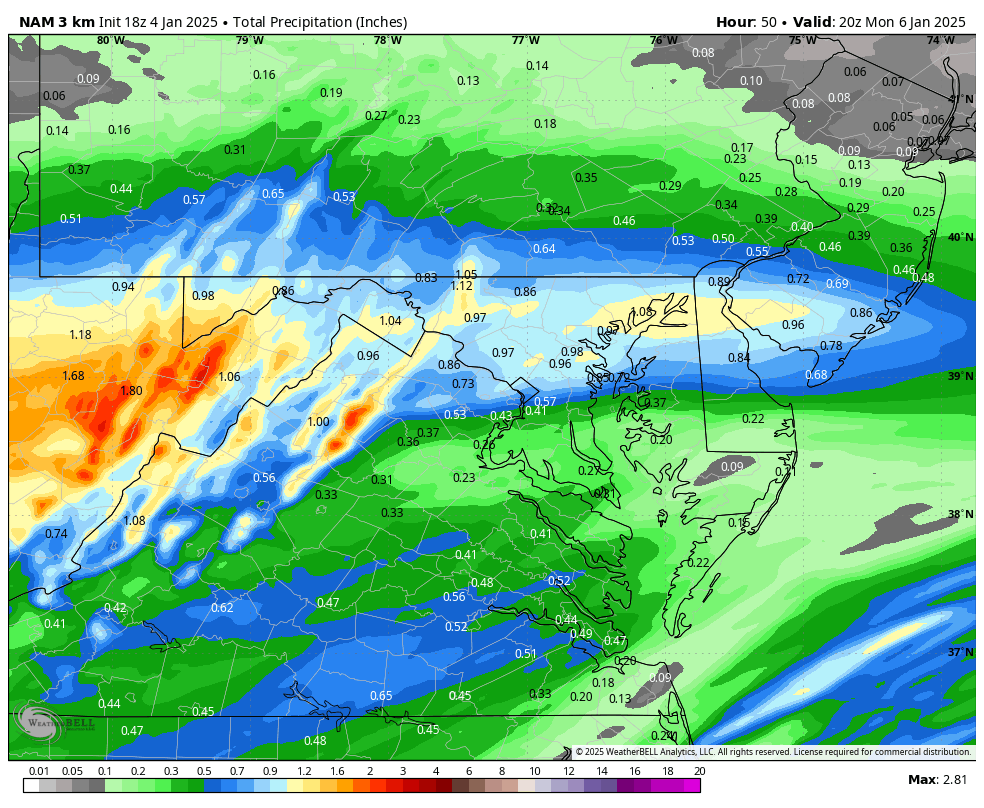
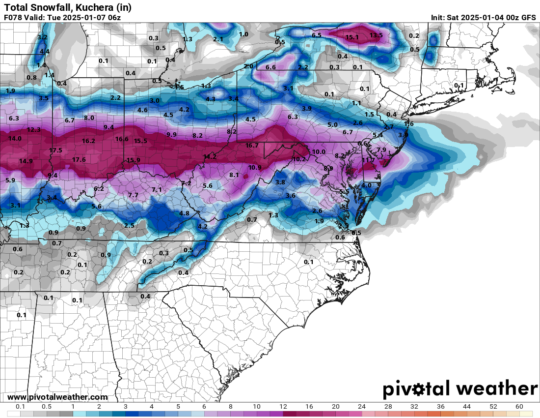
Hmmm how about those higher ratios in southern PA over to southeast PA with .30" liquid I would think 4-6" of snow.
-
1/6 snowstorm - nuisance event or something bigger?
Kevin Reilly replied to LVblizzard's topic in Philadelphia Region
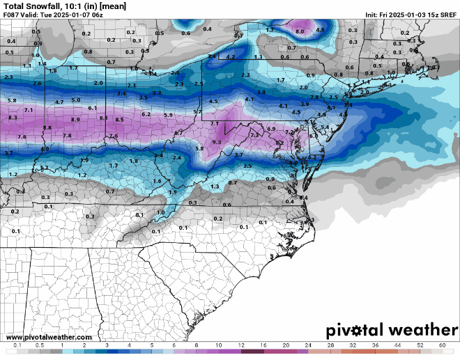
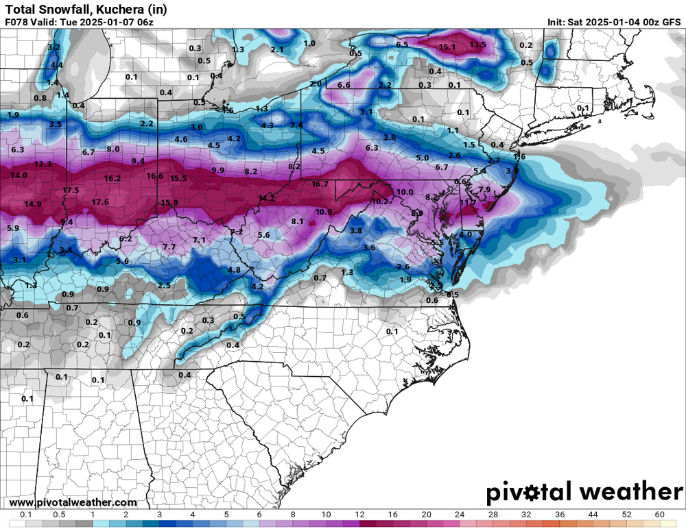
12z gfs I would say down here in Delaware County looks like a 4-6” event not 100% sure what ratios will do but it’s probably in the teens and snowing! We take! Thoughts?
-
1/6 snowstorm - nuisance event or something bigger?
Kevin Reilly replied to LVblizzard's topic in Philadelphia Region
Only problem it's on an island by itself for now. -
E PA/NJ/DE Winter 2024/25 Obs/Discussion
Kevin Reilly replied to JTA66's topic in Philadelphia Region
Currently 31f Cloudy with snow flurries flying: Looks like a pretty good snow shower moving rapidly southeast on the back side of our blocking low pressure that needs to leave like now in order to get out of the way for Monday if we want appreciable snow. Total Snowfall in Media This snow season: 1.88" -
1/6 snowstorm - nuisance event or something bigger?
Kevin Reilly replied to LVblizzard's topic in Philadelphia Region
I mean this thing is just getting crushed south. Hope this confluence helps us with the big one later!! -
1/6 snowstorm - nuisance event or something bigger?
Kevin Reilly replied to LVblizzard's topic in Philadelphia Region

-
January 3, 2025 Light Snow Event Observations
Kevin Reilly replied to ChescoWx's topic in Philadelphia Region
That's what happens when you train a great network of trained NWS spotters. -
To me isn’t this what the gfs and other models showing lobe up north moving further away. I really have a tough time trusting 18z runs there not called off runs for nothing. I’ll be patient until 0z to see real lasting changes or trends as I wave good bye to this little pesky storm stage right and get outta the way of the more important storm on Monday.
-
January 3, 2025 Light Snow Event Observations
Kevin Reilly replied to ChescoWx's topic in Philadelphia Region
30f currently dew point 21f wind NNE 7 mph Total Snow: Coating 0.35" or so underwhelming You can see the low developing to our SE rapidly moving ENE and away....>>>>> That's it leave get out of the way get outta here for and out of the way for our Monday storm. -
You forgot one where the best snow ratios set up in the coldest air on the northern side of the precipitation field.
-
1/6 snowstorm - nuisance event or something bigger?
Kevin Reilly replied to LVblizzard's topic in Philadelphia Region
Actually, those higher amounts in DCA Baltimore and across Delaware into South Jersey very well could be that warm nose aloft causing sleet.